Standardized Precipitation Index Valuation of Seasonal Transitions and Adaptation of Pastoralist to Climate Variability in Rangelands of the Bamenda Highlands of Cameroon
The pastoral community in the Bamenda Highlands of Cameroon continues to face multi-faceted stresses related to climate and the environment. Previous studies have focused more on climate variability in relation to agriculture and water resources, with little or no insights into highland rangeland ecology. These shocks add to the common pool rangeland security issues with unsecure pastoral tenure, land grabbing, rangeland degradation, poor land use planning, dwindling range resources, amongst others. Rainfall data was collected from 13 stations covering the region to understand the climate trend. The Standardized Precipitation Index (SPI) was used to the recurrence of meteorological droughts, vis-Ã -vis transhumance. Results show discernable impacts of climate variability on the pastoral landscape especially related to prolonged dry seasons, pasture scarcity, poor land use practices notably seasonal bush fires, stocking densities and overgrazing. Indigenous knowledge identified pasture scarcity, weed invasion, poor range products, cattle mortality, degradation, land use conflicts, dwindling water resources as related effects. Due to these growing difficulties within the grazing landscape, pastoral communities have resorted to growing partnerships with development agencies to develop more resilience as a result of past challenges grappling with the nefarious effects of climate change. Cultivating improve pastures, fodder crops, developing water schemes and adjusting the grazing calendar are some adaptation measures. Technical and financial resources need to be transferred for risk mitigation and building capacities to reduce the vulnerability of pastoral communities for a sustained future.
Introduction
The effects of climate change on pastoralism are increasingly discernable in Sub-Saharan Africa, World Meteorological Organization 2020 [1], especially in Cameroon and the North West Region in particular. Pastoralism is most affected by seasonal transitions. Climate variability and change poses particular and difficult policy challenges from higher temperatures, intensifying rains and increasingly frequent extreme weather events that exacerbate the problems of agro-pastoral development (Intergovernmental Science Policy Platform on Biodiversity and Ecosystem Services-IPBES 2018 [2]. Pastoralism functions well in the present context of seasonal rhythmic exploitation of the resource base. Land use policy can better be harness and the adaptive capacity of pastoralists improved upon to reduce the vulnerability of land users (Intergovernmental Panel on Climate Change-IPCC 2019 [3]. While grazing takes place in hills and plateau summits during the wet season, it is tilted towards inter-montane inland valleys, plains and lowland edaphic units during the dry season for fresh pasture [4]. Prolonged dry seasons and other extreme events has its toll on pastoralism during seasonal transitions, while other environmental stresses like overstocking aggravate rangeland degradation [5, 6]. One of such debilitating changes is invasive species. Mairomi [7] noted that invasive species, bush encroachment, altered fire regimes, and climate variability are sources of ecological complexity within the region. Again, posited that social complexity is increasing due to land conversion, rising land values, changing demographics and character of rural communities and shrinking producer profit margins. While the inherent autonomous grazing strategies of pastoralist can be improved upon to ameliorate adaptive capacity, risk mitigation through planning and investment with the right polices can reduce vulnerability to shocks [8].
The Bamenda Highlands of Cameroon is dominated with remnants of gallery forests under the threat of overgrazing and unsustainable agricultural practices. This stunted highland vegetation is very resistant to prolonged droughts. Slash and burn farming method the destruction of soil organic matter which often leads to bush fires during the dry season. Bushfires can cause severe consequences for the environment including loss of vegetation and wildlife [9]. These fires also cause changes to the atmosphere such as increased levels of CO2 in the air through large volumes of smoke and ash in the atmosphere during the dry season. The impact of bushfires is devastating on rangeland ecology [8]. Some of the effects are lasting health problems, poverty resulting from loss of livelihood, rural exodus, social displacements, intra-and inter-community conflicts from competition over scarce natural resources and many other negative effects such as insufficient pasture for cattle [10]. Again, the recurrence of seasonal bush fires is a self- inflicted maladaptation by pastoralists themselves. As early as November, they start burning hills as a form of primitive pasture regeneration in some places. Their animals end up suffering due to lack of fodder. Cattle grazing is not only an environmental unfriendly activity because it triggers more pressure on stunted vegetation. Animals also destroy crops, thereby intensifying cultivator-grazier conflicts. This makes the Bamenda Highlands highly vulnerable to climate change like most areas in Sub-Sahara Africa [11].
This paper evaluates the impact of historical rainfall changes on pastoralism and proposes adaptation strategies to such changes. It falls within the context of two key Sustainable Development Goals (SDGs), that is, SDG-13: take urgent action to combat climate change and its impact and SDG-15: protect, restore and promote sustainable use of terrestrial ecosystems, sustainably manage forests, combat desertification, and halt and reverse land degradation and halt biodiversity loss [12]. It also attempts to bridge the research gap from previous studies which focused more climate variability and change and its impact on food and water security [13, 10], and bring new impetus into one of the most sensitive issues in the Bamenda Highlands (seasonal adaptation of pastoralism). The magnitude of cropper- grazier conflicts have increased in the past 15 years in the Bamenda Highlands as a result of uncertainty in seasonal weather patterns. Pastoralists are compelled to move cattle earlier to the frontier zones (when dry season crops have not been harvested), and in the same light, prolonged dry seasons and the prevalence of long dry spells after the onset of first rains again compels pastoralists to stay longer in the frontier zones since uphill pastures have not been regenerated [4, 6]. This creates a wave is disproportionate agro-pastoralist conflicts due to weak adaptive capacity to seasonal changes on the part of cattle graziers.
Study Area and Methodology
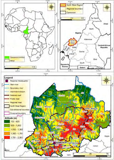
The Bamenda Highlands is chosen for this study and constitutes a major segment of the Western Highlands of Cameroon. Administratively it covers seven divisions of the North West Region: Mezam, Bui, Momo, Donga Mantung, Mechum, Ngoketunjia and Boyo. It is located between latitudes 6°63’ and 7°50’ North and longitudes 6°11’ and 7°16’ East (Figure 1). The topographic zonation of this area provides micro agro-ecological zones with raining grazing sites at high altitudes (˃1500m), mid-altitude (1000- 1500m) and low altitude areas (˂1000m) mostly rainy season grazing grounds in intermontane plains and valleys. Two distinct seasons characterize the area; the dry season from November to mid-March and the wet season from mid- March/April to October.
The interview guide had 11 key items focus on issues related to climate variation impacts, manifestations, adaptations of pastoralist, institutional actions and prospects. Eleven interviews targeted key resource users like elderly pastoralists, heads of grazing units, Delegates of the Ministry of Livestock, Fisheries and Animal Industries, and non-state actors involved in rangeland exploitation and management. Also focus group discussions were organized in grazing communities of the Bamenda Highlands. The FGDs had 5-9 participants with 11 open-ended questions for them to carefully clarify. The FGDs were distributed as follows (Table 1):
| Division | Ardorates | Number of participants | Focus |
|---|---|---|---|
| Boyo | Baigom | 7 | Grazing management, pasture availability, water, institutions, indigenous governance strategies, manifestation of climate variability, adaptations strategies, role of state and non-state stakeholders, participation, prospects |
| Boyo | Achain-Fonfuka | 9 | Grazing management, pasture availability, water, institutions, indigenous governance strategies, manifestation of climate variability, adaptations strategies, role of state and non-state stakeholders, participation, prospects |
| Ngoketunjia | Ndawara | 6 | Grazing management, pasture availability, water, institutions, indigenous governance strategies, manifestation of climate variability, adaptations strategies, role of state and non-state stakeholders, participation, prospects |
| Ngoketunjia | Ntaba | 8 | Grazing management, pasture availability, water, institutions, indigenous governance strategies, manifestation of climate variability, adaptations strategies, role of state and non-state stakeholders, participation, prospects |
| Bui | Berlem | 7 | Grazing management, pasture availability, water, institutions, indigenous governance strategies, manifestation of climate variability, adaptations strategies, role of state and non-state stakeholders, participation, prospects |
| Bui | Ntunir | 8 | Grazing management, pasture availability, water, institutions, indigenous governance strategies, manifestation of climate variability, adaptations strategies, role of state and non-state stakeholders, participation, prospects |
| Menchum | Upkwa | 8 | Grazing management, pasture availability, water, institutions, indigenous governance strategies, manifestation of climate variability, adaptations strategies, role of state and non-state stakeholders, participation, prospects |
| Menchum | Bouru | 5 | Grazing management, pasture availability, water, institutions, indigenous governance strategies, manifestation of climate variability, adaptations strategies, role of state and non-state stakeholders, participation, prospects |
| Mezam | Ndzong | 7 | Grazing management, pasture availability, water, institutions, indigenous governance strategies, manifestation of climate variability, adaptations strategies, role of state and non-state stakeholders, participation, prospects |
| Mezam | Sabga | 8 | Grazing management, pasture availability, water, institutions, indigenous governance strategies, manifestation of climate variability, adaptations strategies, role of state and non-state stakeholders, participation, prospects |
| Donga Mantung | Dumbo | 8 | Grazing management, pasture availability, water, institutions, indigenous governance strategies, manifestation of climate variability, adaptations strategies, role of state and non-state stakeholders, participation, prospects |
| Donga Mantung | Akwintoh | 6 | Grazing management, pasture availability, water, institutions, indigenous governance strategies, manifestation of climate variability, adaptations strategies, role of state and non-state stakeholders, participation, prospects |
| Momo | Ngamunguh | 6 | Grazing management, pasture availability, water, institutions, indigenous governance strategies, manifestation of climate variability, adaptations strategies, role of state and non-state stakeholders, participation, prospects |
Table 1: ** Distribution of Focus Group Discussions.
Source: Fieldwork, 2016 Table 1: Distribution of Focus Group Discussions.
Organised in the mornings and facilitated by Ardors (Fulani-grazier leaders), it focused on early pastoralists who have practiced for long to make appreciation over spatio-temporal changes in resource use and climate. Pidgin English and the Fulbe language were used and a translator to interpret. The data obtained was transcribed and categorized for retrievals through narratives, thematic and framework analysis. This touched climate impacts, adaptations strategies, institutional related aspects and prospects related to participation, empowerment and rangeland management.
Rainfall data was collected for 13 stations across the Bamenda Highlands. These include Bamenda (1963-2019), Kumbo (1975-2016), Ndu (1957-2018), Menchum Valley (2001-2017), Oku (1986-2018), Ndop (1990-2018), Santa (1981-2018), Mbaw Nso (1975-2018), Tubah (1963-2018), Jakiri (1961-2018), Takui (1997-2016), Fundong (1999- 2017), Ndawara (2004-2019). The data was analysed using the Standardized Precipitation Index (SPI). The SPI is a tool which was developed primarily for defining and monitoring drought (Table 2).
SPI allows for the determination of the rarity of a drought at a given time scale (temporal resolution) of interest for any rainfall station with historic data. It can also be used to determine periods of anomalously wet events. Conceptually, SPI is the number of standard deviations by which the precipitation values recorded for a location would differ from the mean over certain periods. In statistical terms, the SPI is equivalent to the Z-score. It is generated as follows:
…………… McKee, et al. (1993) [14]
Where: Z-score expresses the x score’s distance from the mean (µ) in standard deviation (δ) units.
Statistically, the SPI is based on the cumulative probability of a given rainfall event. A meteorological, agricultural or hydrological drought occurs when SPI values fall below zero (0). Such episodes have severe repercussions for rangeland ecology and pastoralism. All graphs generated from the data were fitted with trend lines and linear equations. The trend lines indicate increase or decrease in rainfall.
| Category | Probability (%) | Freq. in 100 years | Severity of event | |
|---|---|---|---|---|
| >2.00 | Extreme wet | 2.3 | 100 | 1 in 1 year |
| 1.5 to 1.99 | Severely wet | 4.4 | 70 | 1 in 1.1 years |
| 1.00 to 1.49 | Moderately wet | 9.2 | 50 | 1 in 1.3 years |
| 0 to 0.99 | Mildly Wet | 34.1 | 45 | 1 in 1.5 years |
| -0.1 to -0.99 | Mild dryness | 34.1 | 33 | 1 in 3 years |
| -1.00 to -1.49 | Moderate dryness | 9.2 | 10 | 1 in 10 years |
| -1.50 to -1.99 | Severe dryness | 4.4 | 5 | 1 in 20 years |
| <-2 | Extreme dryness | 2.3 | 2.5 | 1 in 50 years |
Table 2: ** Drought probability of recurrence.
Source: McKee [14, 15]; World Meteorological Organization [16] Table 2: Drought probability of recurrence.
Results and Discussion
Early Wet Season Rainfall Manifestation
Pastoralists complained of climate variability and declared that they are mostly affected during the months of March and April due to prolonged dry seasons. This claim corroborates the rainfall amounts and erratic pattern of rainfall during this period of transition from the dry to the rainy season in the recent past. It is noticed that the dry season either extends, thereby stretching the period of meteorological drought or the rains start earlier like late February or early March than mid-March when it is often expected and is followed by an early abortive start. A concise examination of rainfall for the past forty years spanning from 1981 to 2019 demonstrates this tendency. The decades during the 1980s, 1990s and 2000 to 2019 saw an alternating number of days of rainfall for the month of March between 11 and 12 days. From 2011 to 2019, this number of days has reduced to between 7 and 10. Though the height of rainfall has not varied much, its rhythm is experiencing a high frequency in concentrated heavy episodes over shorter time lapsed. The pattern, again, is more erratic or variable for the months of March and April. For example, in 2006, there were rains from the 1st to the 3rd of March, observed a break and only continued on the 24th of March in Kumbo (Figure 2).
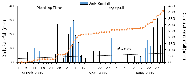
Data source: Tertiary Sisters of St. Francis, Shisong Convent Weather Station Figure 2: The early abortive start of rainfall during March, April and May for Kumbo, 2006
The situation for 2014 was more difficult especially in Wum as pastoralists’ and farmers experience indescribable stress because it involved the month of April. It was a two weeks’ dry period from the 7th to the 22nd resulting to untold difficult conditions to crops and livestock especially as graziers were just returning to the hills after transhumance compounded by water scarcity and pasture scarcity (Figure 3). After constant rainfall in early April, there was a dry spell from the 14th of April to the 17th of May 2006 seriously complicating grazing and farming processes.
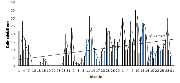
Data source: Regional Service of Meteorology for the NWR, Ministry of Transport Figure 3: Rainfall variation early rainy season for Wum, 2014
Climate Variability Using Standardized Precipitation Index
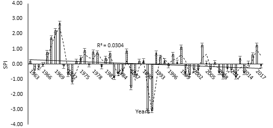
The Standardized Precipitation Index (SPI) is one of the highly rated climatic indices that is used for climate variability and long-term climate change, and it is highly recommended by the World Meteorological Organization. The oldest rainfall data records for this study date back to 1957 for the Ndu Tea Estate. The general trend here shows a slight decrease in rainfall (Figure 4).
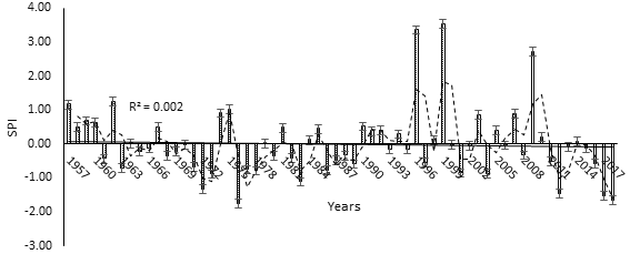
Data source: Cameroon Tea Estate, Ndu Plantation Figure 4: SPI trend for Ndu, 1957-2018.
The SPI events here are distributed as follows: 3 episodes of extreme wet (1996, 1999, 2009), 1 severely wet condition (1975), 2 moderately wet incidents (1962, 1975), 20 mildly wet conditions (1958, 1959, 1960, 1964, 1967, 1974,1979,
1981, 1984, 1985, 1990, 1991, 1992, 1994, 1998, 2003, 2005, 2007, 2010, 2014), 30 mild dryness (1961, 1963, 1965, 1966, 1968, 1969, 1970, 1971, 1973, 1977, 1978, 1980, 1982, 1986, 1987, 1988, 1989, 1993, 1995, 1997, 2000, 2001, 2002,
2004, 2006, 2008, 2011, 2013, 2015, 2016) and 6 conditions of severe dryness (1972, 1976, 1983, 2012, 2017, 2018).
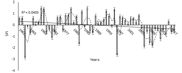
The rainfall trend has been decreasing in Jakiri (Figure 5).
Data source: National Meteorological Service, Bonanjo Douala Figure 5: SPI trend for Jakiri (1961-2018).
It has been marked by 4 severely wet conditions (1969, 1970, 1980, 1986), 3 moderately wet incidents (1984, 1993,1996), 25 mildly wet episodes (1961, 1962, 1966, 1967, 1968, 1975, 1976, 1978, 1979, 1981, 1982, 1989, 1990, 1991, 1992, 1994, 1998, 1999, 2000, 2001, 2002, 2003, 2004, 2005, 2016), 17 incidents of mild dryness (1964,
1965, 1971, 1972, 1977, 1985, 1987, 1988, 1995, 2006, 2008, 2011, 2012, 2014, 2015, 2017, 2018), 7 episodes of severe dryness (1973, 1983, 1997, 2006, 2009, 2010, 2013) and two conditions of extreme dryness (1963, 1997).
Rainfall has also been decreasing for Kumbo (Figure 6).
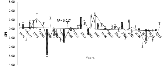
Figure 6: SPI trend for Kumbo (1975-2016). Data source: Tertiary Sisters of St. Francis, Shisong Convent Weather Station Here, there were 3 severely wet incidents (1980, 1996, 1997), 2 moderately wet conditions (1984, 1993), 16 mildly wet incidents (1975, 1976, 1978, 1979, 1982, 1989, 1992, 1994, 1998, 1999, 2000, 2002, 2003, 2005, 2007, 2016), 13 episodes of mild dryness (1981, 1985, 1986, 1990, 1991, 1995, 2001, 2004, 2006, 2008, 2010, 2013, 2015), 6 severely dryness conditions (1977, 1987, 1988, 2011, 2012, 2014) and 1 extreme dryness (1983).
Rainfall trend has been decreasing in Tubah (Figure 7).
It has been characteristics by 2 extreme wet episodes (1969, 1970), 1 severely wet condition (1968), 3 moderately wet incidents (1999, 2004, 2017), 19 mildly wet conditions (1963, 1967, 1974, 1975, 1976, 1978, 1979, 1981, 1982, 1986, 1989, 1990, 1993, 1994, 1995, 1997, 1998, 2007, 2016), 26 mild dryness (1964, 1965, 1966, 1971, 1972, 1977, 1980, 1983, 1984, 1985, 1988, 1996, 2000, 2001, 2002,
2003, 2005, 2006, 2008, 2009, 2010, 2011, 2012, 2014, 2015, 2018), 2 severe dryness (1973, 1987) and 2 extreme dryness (1991, 1992).
Like other stations, rainfall has been decreasing in Mbaw Nso (Figure 8).
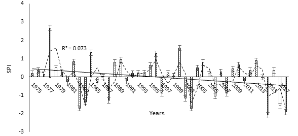
2009, 2010, 2012, 2013, 2016), 7 mild dryness (1981, 1986, 1991, 1997, 2008, 2011, 2014), 8 severe dryness (1983, 1984, 1988, 2001, 2002, 2006, 2017, 2018) and 1 extreme dryness (2015).
Takui, a highland location has also been experiencing declining rainfall (Figure 9).
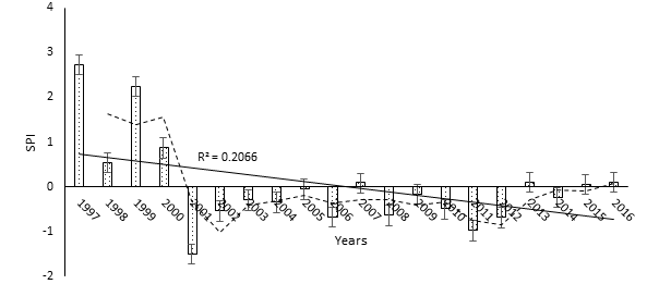
The rainfall has been characterised by 2 extreme wet conditions (1997, 1999), 5 mildly wet (1998, 2007, 2013, 2015, 2016), 11 mild dryness (2002, 2003, 2004, 2005, 2006, 2008, 2009, 2010, 2011, 2012, 2014) and 1 severe dryness (2001).
Santa, another highland location has also experienced a decline in rainfall (Figure 10).
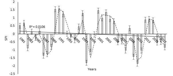
Figure 10: SPI trend for Santa (1981-2018). Data source: Regional Delegation of Transport, Northwest Rainfall here has been characterised by 2 severely wet incidents (1990, 1991), 4 moderately wet (1992, 1997, 2001, 2003), 13 mildly wet (1981, 1982, 1984, 1986, 1993, 1996, 2002, 2004, 2005, 2009, 2013, 2014, 2015), 11 mild dryness (1983, 1985, 1989, 1994, 1995, 2000, 2006, 2007, 2016, 2017, 2018) and 8 severe dryness (1987, 1988, 1998, 1999, 2008, 2010, 2011, 2012).
In Bamenda, the headquarters of the Northwest Region, rainfall has also been decreasing (Figure 11).
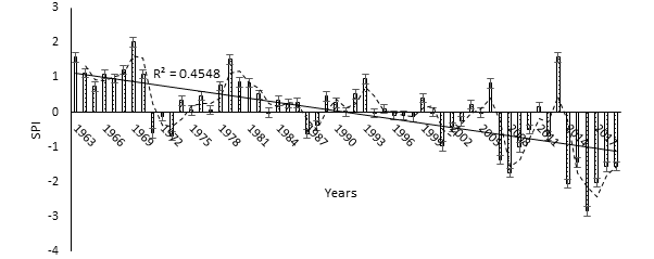
Figure 11: SPI trend for Bamenda (1963-2019). Data source: Regional Delegation of Transport, Northwest It has been characterised by 1 extreme wet (1969), 2 severely wet (1979, 2013), 4 moderately wet (1964, 1966, 1968, 1970), 22 mildly wet (1967, 1974, 1975, 1976, 1977, 1978, 1980, 1981, 1982, 1984, 1985, 1986, 1989, 1990, 1991, 1992, 1993, 1995, 1999, 2004, 2006, 2011), 19 mild dryness (1971, 1972, 1973, 1983, 1987, 1988, 1994, 1996,
1997, 1998, 2000, 2001, 2002, 2003, 2007, 2008, 2009, 2010, 20120, 6 severe dryness (2007, 2008, 2009, 2015, 2018, 2019) and 3 extreme dryness (2014, 2016, 2017).
Ndop, located in a plain has experienced almost stable rainfall (Figure 12).
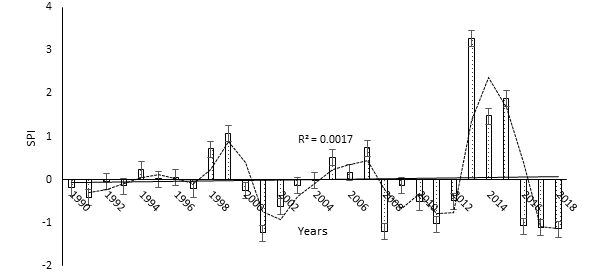
Rainfall here has been characterised by 1 extreme wet episode (2013), 3 moderately wet (1999, 2014, 2015), 7 mildly wet (1994, 1995, 1996, 1998, 2005, 2006, 2007), 12 mild dryness (1990, 1991, 1992, 1993, 1997, 2000, 2002, 2003, 2004, 2009, 2010, 2012) and 6 severe dryness (2001, 2008, 2011, 2016, 2017, 2018).
Oku, located more than 3000 m above sea level has been experiencing declining rainfall (Figure 13).
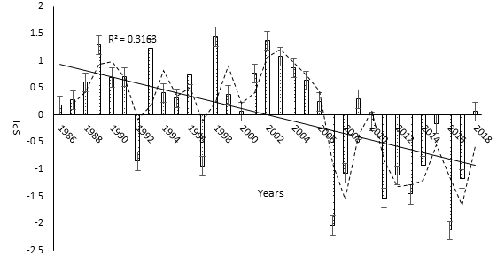
Precipitation here has been characterised by 5 moderately wet (1989, 1993, 1998, 2002, 2003), 16 mildly wet (1986, 1987, 1988, 1990, 1991, 1994, 1995, 1996, 1999, 2000, 2001, 2004, 2005, 2006, 2009, 2018), 5mild dryness (1992, 1997, 2010, 2014, 2015), 5 severe dryness (2008,
2011, 2012, 2013, 2017) and 2 extreme dryness (2007, 2016).
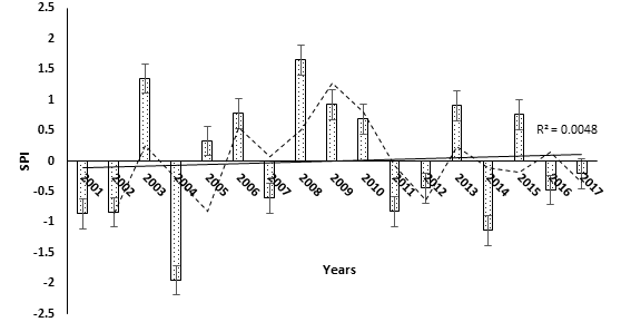
The rainfall trend for the Menchum Valley has been fairly constant, with a slight increasing trend (Figure 14).
Rainfall has also been fairly stable in Fundong (Figure 15).
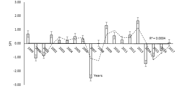
Figure 15: SPI trend for Fundong (1999-2017). Data source: Divisional Delegation of Agriculture and Rural Development, Boyo The SPI episodes have been as follows: 2 moderately wet (2009, 2013), 11 mildly wet (1999, 2002, 2003, 2004, 2005, 2006, 2008, 2010, 2011, 2012, 2017), 2 severe dryness (2000, 2014) and 1 extreme dryness (2007). Ndawara, another highland location is the only station where there is decreasing rainfall above the average (Figure 16).
Figure 16: SPI trend for SPI Ndawara (2004-2019). Data source: Cameroon Tea Estate, Ndawara Plantation The SPI incidents have been as follows: 3 severely wet (2004, 2005, 2019), 3 mildly wet (2006, 2007, 2008), 8 mild dryness (2009, 2010, 2011, 2014, 2015, 2016, 2017, 2018) and 3 severe dryness (2009, 2010, 2011). The rainfall and SPI characteristics are summarized (Table 3).
| Station | Mean annual rainfall | Period | Data size (years) | R2 | SPI trend |
|---|---|---|---|---|---|
| Ndu | 166.17 | 1957-2018 | 62 | 0.002 | Slight decrease |
| Jakiri | 164.99 | 1961-2018 | 58 | 0.0405 | Decrease |
| Kumbo | 173.3 | 1975-2016 | 42 | 0.017 | Decrease |
| Tubah | 184.98 | 1963-2018 | 56 | 0.0304 | Decrease |
| Mbaw Nso | 158.06 | 1975-2018 | 44 | 0.073 | Decrease |
| Takui | 184.21 | 1997-2016 | 20 | 0.2066 | Decrease |
| Santa | 178.46 | 1981-2018 | 38 | 0.0106 | Decrease |
| Bamenda | 182.51 | 1963-2019 | 57 | 0.4548 | Steep decrease |
| Ndop | 153.42 | 1990-2018 | 29 | 0.0017 | Increase |
| Oku | 171.3 | 1986-2018 | 33 | 0.3163 | Steep decrease |
| Menchum Valley | 195.52 | 2001-2017 | 17 | 0.0048 | Slight increase |
| Fundong | 218.01 | 1999-2017 | 19 | 0.0004 | Near stable |
| Ndawara | 187.95 | 2004-2019 | 16 | 0.0181 | Decrease above average |
Table 3: ** Summary of rainfall and SPI characteristics Majority of the stations have decreasing rainfall, with the exception of
Source: Authors’ computation Table 3: Summary of rainfall and SPI characteristics Majority of the stations have decreasing rainfall, with the exception of the Menchum Valley and Fundong. A summary of all the SPI categories and incidents is also presented (Figure 17).
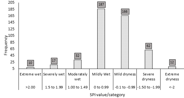
Figure 17: Summary of SPI episodes in the Bamenda Highlands. Source: Authors’ computation The episodes have been distributed as follows: 10 extremely wet, 17 severely wet, 32 moderately wet, 187 mildly wet, 166 mild dryness, 62 severe dryness and 12 extreme dryness. Despite the dominance of more wet periods, rainfall has been declining all over the Bamenda Highlands, with negative consequences on rangeland ecology and agro- pastoralism.
Deteriorating Pastures and Weed Spread
A common effect of climate variability is the fact that pastures wither, thereby weakening plant vigour. The situation is aggravated by unexpected increases in diurnal temperatures and increase in insolation still with hydrophobic nuclei in the atmosphere which causes rainfall decline. Coupled with the poor water retention capacity of most soils in the region, there is rapid exhaustion of soil moisture content especially around the top root horizon by intense evapotranspiration. Thus, pastures are deteriorated with more difficult situations created in the highlands as intermittent rivers take much time (delayed resumption) to start flowing after the dry season, an indication of drought conditions. Rainfall variability in this tropical rain-fed system ushers’ reduction in ground water inputs during this period with liable impacts on pastures and water. Pastoralists and their cattle have to trek longer distances searching for pastures and for water. The wilting that takes place in young crop seedlings after the planting period and germination is enormous in the region and also affects farmers as well as their output. With an early abortive start of rains, pastures start greening up and pastoralist coming from transhumance resume grazing uphill but with drought conditions introduced again, germinating and sprouting pastures suffer wilting compounded by grazing up to tussock removal due to scarcity degrading pastures especially for preferred species.
One important aspect in the grasslands during this period of inconsistence is the noticeable resilience of rangeland weeds to dry spells. Weeds dispose of rhizomes that store more water than grasses. As such, weeds maintain their vigor and growth than the adjacent grasses that instead experience more pressure, overgrazing and stress from grazing or stocking units in this period of adversity. In relation to seasonal development of pastures, some plants have their development slowed down or hastened depending on rainfall consistency because they are so reliant on first rainfall for germination and growth. This is the case of seed reproducing plants. With the early abortive start of rainfall, pasture growth is affected and slowed down due to this inconsistency. On the contrary, those plants that are equipped with well-built underground bulbs, rhizomes and tillers have accumulated resources that enable them start off their cycles earlier and at times even before the start of rains. This is the case of Pteridium aquililium an ‘ecological terrorist’ in rangelands in the region. It develops vegetation in the dry season after bush fires especially during the last half of February and early March just before the start of the rainy season using stored water in their organs or water reserves stored deep down the soil layers. Shoots of this weed readily sprout out from the soil from rhizomes and give them a competitive advantage over the other grasses to spread and grow especially with the coming of rainfall in March. ‘agogo’ (Fulani term for Pteridium aquililium) ensures renewed and faster growth rates compared to adjacent grass with the coming of rainfall and now spreads faster than hitherto invading close to 60% of rangelands in the region (Berlem-Kumbo, Fungom, Ndawara, Ndzong-Santa, Ntunir- Jakiri, Kukube-Nkambe). With inconsistency increasingly noticed in the abortive start of rainfall, Pteridium aquililium shows more resilience given that it is not prone to grazing pressure during this difficult period. The agricultural and grazing calendar prescribes that transhumance ends by the end of March, and that cattle be back to the hills by April which corresponds to this period of uncertainty. Cattle reproduction, milking as well as fattening processes are all enormously affected and reduced during these harsh conditions.
Adaptation Strategies
Nature gives protection against the mounting impacts of climate change that is of incalculable value and irreplaceable. This level of ecosystem damage most acutely affects indigenous peoples, rural communities, and others who depend directly on healthy ecosystems for their livelihoods [17]. Capacity to adapt may be especially limited for those with insecure land tenure and for pastoralists who often lack a voice in how natural resources are managed [18]. In the Bamenda Highlands of Cameroon, pastoralists adapt to climate variability through seasonal rhythmic exploitation and adjustment of agricultural calendars, fodder and hay preparation, agroforestry, water management and zero grazing.
Participatory Inclusive Communal Grazing Adaptations
Through the wealth of pastoral heritage and experience, grazing communities through informal indigenous community-based rangeland management are evolving in grazing strategies and adapting to social and environmental circumstances [7]. Community based management have nursed process-based local adaptations through collective choice arrangements. From open ranging in the past, pastoralist now practice herd split in grazing rotation to optimize pasture use, reduce environmental quality declines and vulnerability. Key areas are reserved for sick and lactating animals during these difficult transitions since such animals don’t go for transhumance. Smaller ruminants like goats and sheep are grazed especially in higher altitudes like in Mt Oku (1800-2800m). In fact, most pastoralist highlight changing local rules with more responsible behavior on timing, place and zoning. During the 20th century, pastoralism was hitherto marked by self-inflicted maladaptations by pastoralists themselves through seasonal bush fires applied haphazardly at different moments by the end of the rainy season. As early as November, they start burning hills as a form of primitive pasture regeneration. Their animals end up suffering due to lack of fodder. With the growing informal institutional norms, there are still factors that demotivates pastoralist to flaw communal principles and such incongruence is reducing with participation. Due to some problems like tenure security, failures bring indiscriminate burning. But pastoralist in collaboration with state (MINEPIA, local councils) and non-state actors (Netherlands Development Association SNV, Association pour la promotion de l’elevage en Savane, APESS), compliance in organize burning has gained ground coordinated by heads of grazing units “Ardors”. Fire is now applied especially in late January and early February to clear old rank grass, eliminate animal pest and regenerate pastures in preparation for the rainy season. There is patchy burning according to sections with instructions from the Ardorate that reduces environmental destruction, protects fences and ensures fire mastery.
Indigenous grazing communities “Ardorates” operating in consensus-based community participation in rangeland settings have evolved in their local management and adaptation strategies. Water is communal owned and, in the past, pastoralist took animals to different locations at different moments with marked destruction of river banks and water catchments. With pasture and water scarcity as growing discernable impacts of climate variability, grazing communities have resorted to more inclined community- based attitudes in managing water. First in some grazing units, there is herd split and distribution of herds and locations where watering is carried out, second, there is respect of turns with given number of herds having access at a time and others later, third, from an environmental perspective, the protection of water catchments and fourth, collaboration with development partners like the local councils, GP- DERURDEP, USAID United State Agency for International Development in modifications of water regimes and realizing water schemes to have perennial water supplies that obviate the need for migration. The perception of pastoralist in locally led adaptions is changing from individualistic tendencies to community target objectives and collaboration with different stakeholders to build resilience.
In as much as local adaptations are driven by endogenous forces, it was noticed that they are hardly achieved without support from development agencies that bring technical and financial support. Field empirical evidence underlines this complementarity of indigenous pastoral communities and development agencies. Though the contributions of these agencies are fragmented, not well coordinated and tend to overlap in function of their interest, their modest support is enormously assisting pastoralists in sensitization and realization of some local adaptations.
Seasonal Rhythmic Exploitation and Adjustment of Agricultural Calendars
Essentially, the idea is that environment factors are all- powerful and determine what happens. The physical milieu has a great role to play in so far as the rhythmic exploitation of resources in the area is concern. This is because the physical elements of relief, soils and geology, climate flora and fauna are not homogenous over the region. They thus exist great spatial variations of physical phemomena throughout the area which has given a flora and fauna zonation. The relief zonation gives rise to high lands and lowlands which together with the annual rhythm of rainfall and temperature determine land use in terms of pastoral activity. Grazing activity is carried out in the uplands during the rainy season and the seasonal rhythmic change in climate to the dry season directs grazing activities towards the wet flood plains and wet inland valleys (Table 4).
| Transhumance zones | Topographic site | Number of cattle |
|---|---|---|
| Inland valleys | Katsina Ala Basin | 5700 |
| Inland valleys | Bui-Lip valley | 5200 |
| Inland valleys | Munduni-Upper Menchum | 9000 |
| Inland valleys | Njimikimbi | 10800 |
| Inland valleys | Menchum Valley | 5400 |
| Inland valleys | Kumbi-Ijim, Kom | 9500 |
| Plains | Ndop | 36000 |
| Plains | Dumbo-Misaje | 40000 |
| Plains | Mbaw Nso, Sabongari, Ngu | 34000 |
| Plains | Mfumte-Ako, Mayo Binka | 42000 |
| Other edaphic units | Bamti lowlands-Noni | 2650 |
| Other edaphic units | Nyos | 320 |
Table 4: ** Dry season grazing sites and cattle reception during transhumance.
Source: Compiled from field inquires and MINEPIA reports, 2015 Table 4: Dry season grazing sites and cattle reception during transhumance.
With scorching pastures in upland areas during the dry season comes the period of transhumance; a seasonal movement of pastoralists with their cattle during the dry season to plains and valleys in search of fresh pastures. It is worth noting that transhumance in Bamenda Highlands is tilted towards low altitude (˂1000m) or lowland areas. These areas include the Bamti lowlands in the Noni area and Misaje lowlands (Dumbo cattle ranch, Kimbi and Katsina valleys), the Mbaw-Tikar plain recieving cattle from Dzeng- Mbiami Plateau, Ndu and Nwa highlands, the Ndop plain with cattle from the Sabga-Santa stretch to the Jakiri plateau and the Menchum valley receiving cattle from neighbouring highlands of Wum, Esu, Bafmeng and Nyos hills (Figure 18, Table 5). Due to difficult conditions uphill owing to rainfall irregularities and pasture scarcity, graziers delay to stay in lowland areas a little more till when uphills are greening up. As such, there are distortions in the agricultural calendar. This delay causes destruction of germinating crops causing conflicts with farmers. The over 200000 herds of cattle that go on transhumance are in a delicate period. The situation is getting worse in Menchum valley with increasing infestation of this area by C. odorata.
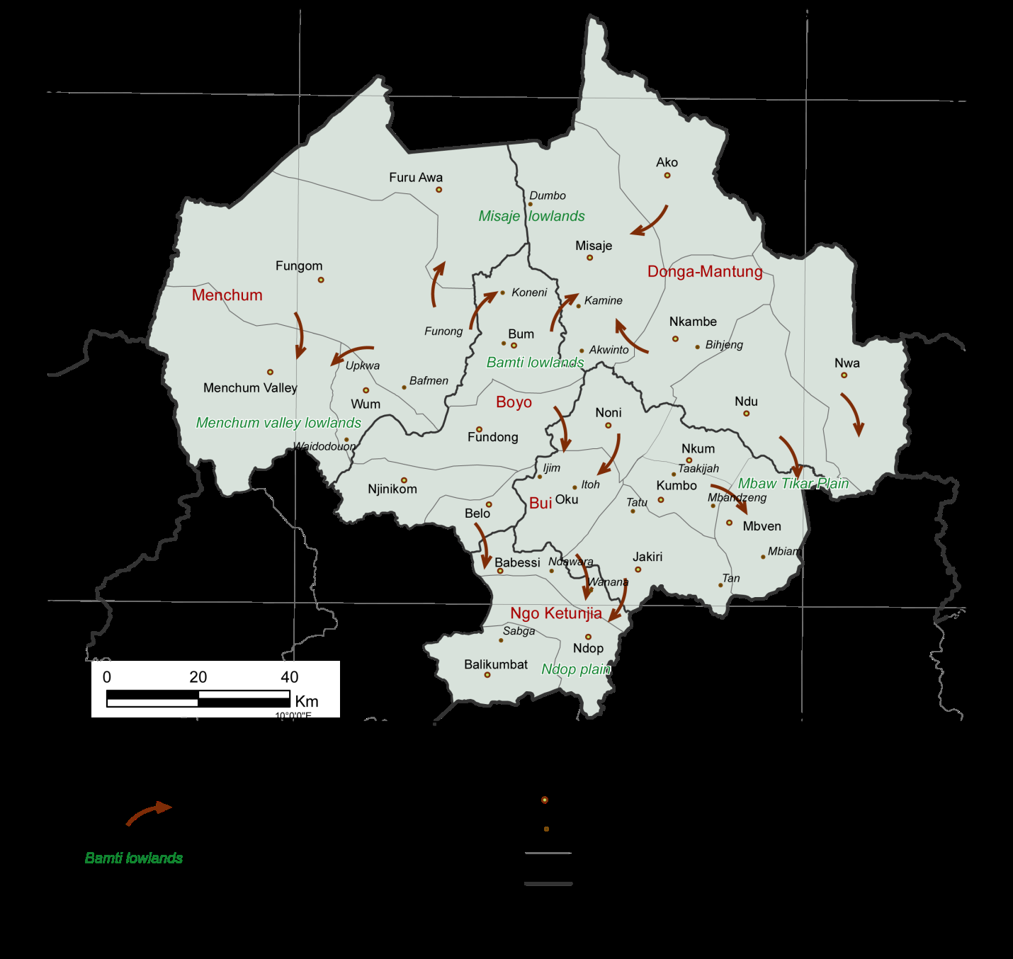
Figure 18: Cattle movement during transhumance in the Bamenda Highlands. Source: Fieldwork 2015 The periodicity of land use activities looks well map out according to the seasonal rhythm but there is no clear delimitation for transhumance as well as climatic variations that cause distortion in the agricultural calendar either hastening or delaying periodic activities. An important aspect is finding the right balance between pasture regeneration and grazing. Delegates from the ministry of Agriculture and Rural Development and that of Livestock, Fisheries and animal Husbandry have concerted over the years and the consensus arrived at has been that two weeks after the arrival of rainfall, pastoralist should move cattle back to rainy season grazing grounds. This corresponds to the time most crops are germinating after planting to avoid conflicts with farmers.
| Activity | Periodicity of activity | |||||||||||
|---|---|---|---|---|---|---|---|---|---|---|---|---|
| Oct | Nov | Dec | Jan | Feb | Mar | Apr | May | Jun | Jul | Aug | Sep | |
| Forage manufacture | ||||||||||||
| Milking | ||||||||||||
| Processing & marketing of milk | ||||||||||||
| Land preparation | ||||||||||||
| Planting of crops/pasture | ||||||||||||
| Irrigation | ||||||||||||
| Weeding | ||||||||||||
| Crop/hay, pasture seed harvesting | ||||||||||||
| Grazing in the rainy season | ||||||||||||
| Forage preservation | ||||||||||||
| Transhumance | ||||||||||||
| Burning & Regeneration |
Table 5: Periodicity of grazing/dairying activities in the Bamenda Highlands.
Source: Mairomi, 2012 Table 5: Periodicity of grazing/dairying activities in the Bamenda Highlands.
Fernandez Gimenez [19] describes the mobile pastoral system as the “paradox of pastoral land tenure” in that pastoralist need secure access to pasture and water but also flexibility in resource use, that is, the ability to move elsewhere because of spatio-temporal variation in resource availability [20]. Flexibility in adaptation and reducing the vulnerabilities of communities by adjusting the agricultural calendar has not been easy. Nevertheless, farmers and pastoralist are improving their perception and understanding of variations thus adapting better to contentious circumstances for their resource base at the beginning of the wet season.
Fodder and Hay Preparation
With some minimum institutional structures, some pastoralists are building their resilience by cultivating hay and preparing for the dry season. In the SODEPA state ranch in Jakiri, it is native stand of Hyparrhenia rufa (Photo 2) often prepared against the adverse period. Other pastoralist in the area also negotiate to have access to hay. In other private ranches like the Elba ranch in Ndawara, Tadu dairy ranch, Philomon yang ranch, Achidi Achu ranch in Santa, it is the cultivation of improve pastures like Brachiaria ruziziensis (Photo 3). Nevertheless, with tenure problems as most rangelands are communal in nature, pasture improvement is only seen where there are some appreciable institutional frameworks like the Itoh community graziers in Oku. Individuals with small enclosures and ranches do modify the landscape, not only to increase the yield of a particular species, but to breed varieties which will withstand less favourable physical conditions and so make it possible to extend their habitat. Such is the case of cultivated vegetation which forms an important part of a predominant land- use map that distinguishes such categories as improved pastures. Such landscapes are identified in Jakiri, Tadu, Santa and Upkwa-Wum areas notably with Brachiaria ruziziensis, Pennisetum clandestinum, Trypsacum laxum. Improving the forage available for grazing requires a whole lot of effort. Bracharia grass is one the most palatable species today that most ranchers have embarked upon. It does relatively well especially when cultivated as a forage crop in ploughed fields. It is best cultivated in the months of May and June when there is ample rainfall. Seeds are spread after the fields most have been ploughed. Cattle graze on it in the fields and by the month of November when the seeds are ready for harvest. Seeds of most of these grasses or shrubs are obtained by hand harvesting from wild land stands or from cultivated stands for seed multiplication. Seeds can be stripped or flailed directly into canvas hoppers, tubs, boxes, trash cans or other appropriate receptacles [21]. These are the most widely used harvesting procedures especially cutting with knives. Freshy fruits are beaten or handpicked. Bracharia is one of the most important species of grass that is used during the dry season when there is acute forage shortage. It is particularly graze by cattle in the early parts of the dry season especially the months of December and January. It is harvested and stored in shades when it attains maturity. When well stored, it retains all its nutrients content. Cattle feed on it when spread with salt and used in the dry season.
Agroforestry
Pastoralists are being sensitized on the use of forage legumes to reduce feed deficiencies and improve the quality of available feed during the dry season. The use of high yielding legumes as a sole crop or in mixture with grasses is a way of achieving year-round quality forage. Stylosanthes guianensis, Leucaena leucocephala or Calliandra calothyrsus have emerged among the best forage legumes and are the most widely diffused though still very limited. However, seed production remains a major constraint due to lack of appropriate structures. Stylosanthes guianensis has been recommended for sown pastures while Leucaena leucocephala or Calliandra calothyrsus are recommended for fence lines to be used as forage during the dry season. The latter is highly recommended protein forage that is encouraged for paddocking. An evaluation of variation in nutritive levels reveals that crude proteins levels are higher for leaves of leguminous plants than grass species throughout the year. This has been revealed for Leucaena leucocephala, Calliandra calothyrsus, Bracharia ruziziensis and Pennisetum purpureum. As such this is the more reason why TDCS is encouraging its member to embark on these trees to be used as supplements in the diets of ruminants to reduce aggregate live weight losses in animals. Guatemala-Trypsacum laxum (Photo 1) and other harvested hay are therefore used as a standing fodder crop to buffer seasonal fluctuations (dry seasons). Fodder crops are useful as they reduce grazing pressure on degraded areas, serve as a protein supplement for livestock in poor native or low quality roughage, a means of soil erosion control and as an emergency feed during the dry seasons. Thus, livestock is grazed on native pastures such as Sporobolus africanus, Pennisetum purporeum and Melinis multiflora and improve planted grasses, legumes and multipurpose trees (MPT) (Table 6).
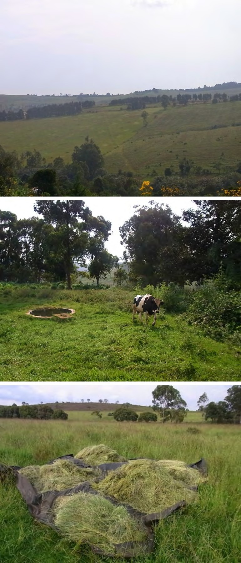
Photo 1: Typsacum laxum cultivated as a buffer Photo 2: Hay preparation in Jakiri Photo 3: Brachiaria ruziziensis cultivated for seed propagation and hay Photo 4: Water ponds Source: Mairomi, 2016 [7]
| Importance | |
|---|---|
| Brachiaria riziziensis | Protein and carbohydrate pasture, propagated both by seed and vegetative |
| Pennisetum clandestinum (Kikuyu grass) | Noted for resilience in the dry season, especially good and recommended for ruminant grazing in dry season. Mostly vegetative propagation and controls erosion |
| Guatemala (Trypsacum laxum) | Carbohydrate forage crop with coarse leaves. Good for use in dry season and is transplanted through suckers |
| Stylosanthes guianensis | Browse forage, leaves |
| Stylosanthes scrabra | Multipurpose leguminous trees (MPLT) |
| Calliandra calothyrsus | High protein forage all year round, facilitates nitrogen fixation biologically |
| Leucaena leucocephala Acacia sp | Used for fencing or paddocking especially with fire tracing. Keeping animal live weight during dry season. Propagated by seed and limited in use |
Table 6: Some pasture and forage species and their importances. Source: Field inquires with delegates of Livestock
Water Management
Spatio-temporal variability of water resources due to seasonality expresses the need for mobility. Intermittent streams get dry during the dry season and with climatic anomalies at the start of the rainy season resumption in flow retards causing difficulties for cattle and pastoralist. In some grazing communities, a number of water projects have been conceived and some realized with the aid of the local councils and development partners. This does not only improve the living conditions of the grazing communities but goes a long way to improve grazing because it reduces the health complications of animals and inland valley search of water. The added advantage is that stream bank trampling is avoided and better community strategies for grazing can be earmarked upon. Equally cattle no longer trek for long distances in search of water in some areas. In areas where water projects have been realized, graziers confirmed that animal fattening can now be ensured with renewed hope since energy wasted in search of water can now be reserved. Moreover, since animals will reduce inland valley movements in search of water, farmer grazier conflicts are greatly reduced. Most of the inland valleys in the study area have been cultivated. When animals go to drink there is always a likelihood of crop destruction. With water supplied in the grazing fields, encroaching farmers would cultivate their crops in neighbouring slopes and inland valleys without much threat from grazing. The two land use practices would then be developed with better harmony.
With the aid of community participation, a number of grazing areas among the dairy districts of the Tadu Dairy Cooperative Society have benefitted from water development schemes. Among these can be sited Tan, Tadu, Tashem, Farkuuy with huge assistance from the Jakiri council. Similar initiatives were noted in Kukube in Nkambe, Waidodown in Wum and in state and private ranches in the region. The only caution required here is to provide disperse water supplies to livestock. But it’s important to bear in mind that any measures to disperse and to protect water sources must be complemented by efforts to control access to them. Left to themselves, cows will tend to congregate around water, and therefore trample the vicinity, so water tanks and fencing tend to go together.
Water management is thus considered as a tool for rangeland rehabilitation. Planning of water management should revolve around optimum location and spacing of water points and their capacity, in terms of the number of stocking units they can water as well as avoiding environmental degradation. However, it requires precaution to prevent cases of poorly constructed water points and their ineffective management. This is to avoid situations where a few years after construction, some of these water points are no longer in use. Experienced can be drawn from the Mindif- Moulvoudaye agropastoral project of North Cameroon where non out of four stock ponds dug in 1984 were in operation by 1993 Pamo [22]. Capacity and spatial distribution influence productivity per animal and the nature and intensity exerted on soil and the vegetation. Customary watering schedules, human organization and management of livestock and grazing resources can only be realized through community- based rangeland management (CBRM) in the grazing zones.
Zero Grazing
Zero grazing is only adopted for sick and lactating animals that are stall-fed on spot. It also involves improve breeds of cattle like Holstein Friesian mostly found in ranches and some individuals mostly working with NGOs
like HEIFER Project and dairy societies for milk collection. Other beef species are brahma and sementa. This system obviates the need for field grazing but intensifies the need for pasture and fodder cultivation and preparation that sustain the system during the dry season especially during periods of climatic anomalies. A good number of pastoralists practice this system in Santa, Wum, Jakiri and Tadu. Nevertheless, the scale of this system remains very small and insignificant.
Conclusion
Throughout the region livestock production has been intensified through the application of new technologies and practices, such as insemination, the seeding of high-yielding grass and legume species, modifications to the natural water regime, and heavy grazing through high stocking rates. The principal problem of intensive grazing is to provide enough high quality fodder during the dry season to adapt to climate variability. Pastoralist and livestock agents are readjusting their activities to adapt and mitigate the impacts of climate variation especially during transhumance at the transition to the rainy season. Much needs to be done to improve the adaptive capacity of pastoralist through collaboration with the local councils and development agencies. Governance of rangelands need to recognize tenure and access rights and pastoral mobility and facilitate the adoption of the Cameroon pastoral code to enhance investment to build on autonomous or inherent indigenous strategies to mitigate risk and adapt to extreme climatic variability. Strengthening the adherence and commitment of pastoralist institutions or grazing groups through community base management in stepping up engagement in improving pastures, adopting agroforestry and improving water regimes. Knowledge can be developed and shared on climate change adaptations from national institutions and pastoralists groups. With the present adaptation strategies, it will be a herculean task for this sector to meet the targets of SDGs 13 and 15. A more robust and inclusive adaptation plan should follow the World Bank [23] adaptation principles, viz, adapt land use plans and protect critical assets and ecosystem services, help people (pastoralists) manage risks and natural disasters, prioritization, implementation and monitoring progress in rangeland ecosystems management [24, 25, 26, 27].
References
-
World Meteorological Organization (2020) State of the Climate in Africa, 2019. WMO (1253), Geneva, pp: 1-33.
-
Intergovernmental Science Policy Platform on Biodiversity and Ecosystem Services (IPBES) (2018) The IPBES assessment report on land degradation and restoration. IPBES, Bonn, pp: 1-40.
-
Intergovernmental Panel on Climate Change-IPCC (2019) Global Warming of 1.5°C. An IPCC Special Report on the impacts of global warming of 1.5°C above pre-industrial levels and related global greenhouse gas emission pathways, in the context of strengthening the global response to the threat of climate change, sustainable development, and efforts to eradicate poverty. IPCC Secretariate, Bonn, 35-40.
-
Tume SJP, Fogwe ZN (2018) Standardised Precipitation Index Valuation of Crop Production Responses to Climate Variability on the Bui Plateau, Northwest Region of Cameroon. Journal of Arts and Humanities (JAH), Faculty of Arts, The University of Bamenda 1(2): 21-38.
-
Intergovernmental Panel on Climate Change-IPCC (2019) Special Report on Climate Change, Desertification, Land Degradation, Sustainable Land Management, Food Security, and Greenhouse gas fluxes in Terrestrial Ecosystems. IPCC Secretariate, Bonn: 1-35.
-
Tume SJP, Nyuykighan MD, Kongnso ME, Dzeaye BA, Mairong F, et al. (2019) Food Crop Vulnerability to Climate Variability and Change at the Household Level in Bui Division, Northwest Cameroon. In Kuwornu JKM (Ed.), Climate Change and Sub-Saharan Africa: The Vulnerability and Adaptation of Food Supply Chain Actors. Vernon Press, Wilmington, Delaware, pp: 61-82.
-
Mairomi HW (2016) Weed invasions in rangelands, tracking system dynamism in the Western Highlands of Cameroon. PhD Thesis, Department of Geography, University of Yaounde I, pp: 422.
-
Banuri T, Prates FF, Martino D, Murthy IK, Park J, et al. (2019) Global Environment Outlook GEO-6: Healthy Planet, Healthy People. Cambridge University Press, Cambridge, pp: 1-40.
-
Tume SJP, Mbilam SJ, Ndze AN, Ngoran DN, Lawong JY, et al. (2018) Role of the Media in Climate Change Communication in the Northwest Region of Cameroon. In: Filho WL, Azeiteiro U, Manolas E (Eds.), (2018): Handbook of Climate Change Communication, Volume 2: Practice of Climate Change Communication. Springer, Cham.
-
Tume SJP, Zetem CC, Nulah SM, Ateh EN, Mbuh, et al. (2020) Climate Change and Food Security in the Bamenda Highlands of Cameroon. In Squires VR, Mahesh Gaur MK, (Eds.), Food Security and Land Use Change under Conditions of Climate Variability: A Multidimensional Perspective. Springer Cham, pp: 107-124.
-
Tume SJP, Kongnso ME, Nyukighan MB, Dindze NE, Njodzeka GN (2018) Stakeholders in Climate Change Communication in the Northwest Region of Cameroon. In: Tume S.J.P., & Tanyanyiwa, V.I., (Eds.), (2018): Climate Change Perception and Changing Agents in Africa & South Asia. Vernon Press. Wilmington, Delaware. First Edition, ISBN 978-1-62273-308-8, 97-116.
-
Sachs J, Schmidt-Traub G, Kroll C, Lafortune G, Fuller G, et al. (2020) The Sustainable Development Goals and COVID-19: Sustainable Development Report 2020. Cambridge: Cambridge University Press, 5.
-
Tume SJP, Kimengsi JN, Fogwe ZN (2019) Indigenous Knowledge and Farmer Perceptions of Climate and Ecological Changes in the Bamenda Highlands of Cameroon: Insights from the Bui Plateau. Climate 7(12): 138.
-
McKee TB, Doesken NJ, Kleist J (1993) The Relationship of Drought Frequency and Duration to Time Scales. Proceedings of the Eighth Conference on Applied Climatology 17-22.
-
McKee TB, Doesken NJ, Kleist J (1995) Drought Monitoring with Multiple Time Scales. Proceedings of the Ninth Conference on Applied Climatology. American Meteorological Society, Boston.
-
World Meteorological Organization (2012) Standardized Precipitation Index User Guide. WMO (1090), Geneva, pp: 50.
-
Cooper PJM, Dimes J, Rao KPC, Shapiro B, Shiferaw B, et al. (2006) Coping better with current climatic variability in the rain-fed farming systems of Sub-Saharan Africa: A dress rehearsal for adapting to future climate change? Global theme on Agroecosystems, Report No. 27, International Crop Research Institute for the Semi-Arid Tropics, ICRISAT, pp: 18.
-
Kapos V, Wicander S, Salvaterra T, Hicks C, Dawkins K (2019) Role of Natural Environment in Adaptation: Adapt Now: A Global Call for Leadership on Climate Resilience. Global Commission on Adaptation, Global Centre on Adaptation and World Resources Institute, pp:
-
Fernandez-Gimenez ME (2002) Spatial and social boundaries and the paradox of pastoral land tenure: A case study from pastoralist Mongolia. Human Ecology 30: 49-79.
-
Turner MD (1999) The role of social networks, indefinite boundaries and political bargaining in maintaining the ecological and economic resiliency of the transhumance systems of Sudano-Sahelian West Africa. In Managing mobility in African rangelands, M. Niamir-Fuller, London, IT, pp: 97-123.
-
Bayemi PH, Bryant MJ (2005) Participatory Rural Appraisal of Dairy Farms in North West Province of Cameroon, pp: 22.
-
Pamo TE, Pamo TC (1991) An evaluation of the problems of open range use system in Northern Cameroon. Tropicultura 9(3): 125-128.
-
World Bank (2020) Adaptation Principles: A Guide for Designing Strategies for Climate Change Adaptation and Resilience_._ Washington, D.C., pp: 1-5.
-
Arthur SB, Adam Blench (1998) Fundamental Ecology. Intext Educational Publishers. University of California, Irvine, pp: 222.
-
Maryam N (1990) Traditional African Range Management Techniques: Implications for rangeland Development, pp: 21.
-
Moritz M, Bebisse L, Drent A, Kari S, Mouhaman A, et al. (2013) Rangeland in an open system: Protecting transhumance corridors in the Far North Region of Cameroon. Pastoralism: Research, Policy and Practice 3: 26.
-
Patt AG, Gwata C (2002) Effective seasonal climate forecasts applications: Examining constraints for subsistence farmers in Zimbabwe. Global Environmental Change 12(3): 185-195.
- Lessons to Learn: Trees are More than the Lungs of the World
- Community Forestry Enterprises as a Model for Sustainable Forest Development: The Case Of The "Baja Tarahumara" in Chihuahua, Mexico
- Ecological and Socio-Economic Impacts of Chromolaena odorata and Mesosphaerum suaveolens, Two Invasive Alien Species in Central and Southern Benin, West Africa
- Epigenetic Sustainability: Modeling the Human Factor as a Natural Resource through Science 4.0 and the NR3C1 Biological Pilot
- Growth-at-Risk: A Framework for Assessing Economic Vulnerability
- The Rural Territory as a Socioecological System for the Management of Public Policy for Sustainable Rural Development