Land use Pattern in Coastal Areas of Lagos State: Issues and Challenges
An explosion in population, economic development in coastal cities worldwide lead to severe issues and challenges. One reason is that physical planning faces diverse social, economic and political challenges which hinder an organized and planned urban development, therefore leading to issues. This paper examines land use pattern in the coastal area of Lagos state: issues and challenges using both primary and secondary data. The result of the remote sensing analysis of google earth exposed that urban development was stronger in the study area (3.6% increase between 2011, 4.7% increase between 2017, and 12.5% between 2020). Also, the study showed that land-use planning flops due to the lack of implementation of legal regulations, laws, population surge. The study recommends the development of strategies that discourage the disturbance of swamp habitat and funding of more research on the implication of land use, health and life expectancy, and wetlands.
Introduction
Coastal areas are highly dynamic and undergoing rapid change [1]. Globally, urban sprawl is one of the key drivers of unsustainable development [2]. Natural hazards and extreme weather patterns impose risks on coastal areas that inland areas seldom encounter [3]. North Africa’s increasingly populous cities face tangible risks today, but these will be amplified as the impacts of global climate change further manifest themselves over the decades to come [4]. In the 1960s and 70s, after the colonial rule, new bureaucracies, infrastructure, and companies employed coastal urban centres [5]. This led to rapid immigration to urban areas in coastal areas of Anglophone Africa.
This makes it attractive because of the diverse opportunities available, improved social care and/or escape from armed conflicts and non-dependency on agriculture and diversify household income [6]. Africa’s coastal cities have long benefited from their ready access to commerce and culture, also face distinct vulnerabilities due to their location [7]. The coastal zones in West Africa were fast-growing, for examples during the colonial era’s commercial activities channel strategically along the sea coast [8]. Its negative impacts are particularly visible and crucial in the settlement of developing countries cities such as Lagos, Nigeria, where unplanned land-use change obstructs sustainable management efforts.
In most developing economies, sustainability challenges emanating from the sprawling expansion of cities are synonymous with informal land use and tenure. Disorderly subdivision layout patterns, lack of public infrastructure and services, poverty, informal livelihood, increased social and economic costs, environmental degradation, loss of agricultural land and diminution of natural resources like forest and high-biodiversity wetlands are also obvious problems [9, 10]. Several studies on the growth of the Lagos Megacity documented the general consequences of spatial expansion and peri-urbanization. This reflects in the challenges and incompetence of physical planning at a megacity scale and the dominance of unsustainable land use planning decisions [9].
The notion of Land-use change has been central to the sustainability debate because it a main driving force of global environmental change and it affects the earth systems as seen in the literature [9]. The Impacts of land use/land cover change are felt from global to local scales; there is worldwide biodiversity loss, global deforestation, global climate change via carbon circle, soil degradation and the ability of the biological systems to support human needs [3, 11, 12, 6, 2]. The sea‐level changes will likely continue for centuries even if greenhouse gas (GHG) emissions concentrations were to be stabilized owing to the time scales associated with climate processes and feedbacks [13]. In Lagos megacities, being the prominent manufacturing and port city in West Africa.
Lagos is the heart of the business and economic development in Nigeria, accommodating about 65 per cent of the country’s industrial establishments, more than 65 per cent of all commercial activities and around 60 per cent of Nigeria’s non-oil economy; it is also home to four of the country’s eight seaports [14]. The study also, affirmed that Lagos has been categorized as one of 50 cities most exposed to extreme sea levels, and is projected to experience a more than 800 per cent increase in population exposure by the 2070s. All this, coupled with other factors, lead to altered landscape patterns of urban areas due to substantial growth experienced by these areas over the years. The change in the landscape pattern is substantially caused by natural and human factors, through human activities such as population increase, urban sprawl, and agriculture which can affect the ecosystem and alter the relationships between people and their natural environment [15].
The expansion of urban areas and continued sprawl is negatively affecting developing countries, the residential and industrial intrusions of growing urban areas lead to a constant decrease of high-quality agricultural land and forests in the marginal areas of cities and rural areas. This higher population pressure in Lagos has led to extreme pressure on natural resources [7]. For example, in the past four decades, urban expansion in Lagos triggered deforestation processes. Land use planning is key to meeting increasing demands for human needs and at the same time maintaining the natural environment. Land use denotes the uses of land for different purposes, which includes wildlife habitat, forest-agriculture, industrial, tourism, and settlement etc [16]. It is important in planning and management activities concerned with the surface of the earth [6].
The trend of land uses in coastal areas of Lagos is remarkable over the last half-century [17]. However, much still need remains to be done in implementing the new urban Agenda (2030); Coastal Zone Policy (2005) and the establishment of Integrated Coastal Zone Management (ICZM)- coordination, demarcation of land zoning, mangrove afforestation through community participation, better preparedness against disaster and the introduction of modern land management systems [3, 18]. In light of this, the study intends to understand the pattern, trends and their consequences of land-use pattern in the study area [19]. In light of the above, this paper examines the land use pattern in coastal areas of Lagos State.
Methods and Materials
This study was conducted using a mixture of primary and secondary data. The primary data was source through the use of a questionnaire which was systematically administered in a selected area within Lagos megacities (peri-urban areas). The secondary data were source from scholarly published works. The results of the data were analyzed and presented in a table.
Results of Findings and Discussion
Integrative Analysis of Interviews, Google Earth and literature
In the following, we present a comparative and integrative analysis of our three different data sets. Table 1 and 2, to which we refer throughout the text, provide information on integrative analysis of interviews explored to assess how reliable the observed or assumed trends and patterns of urban development in the study area.
| Pattern of Changes | Confidence | |
|---|---|---|
| Urban sprawl | Very High | Very Low |
| Land fragmentation | Very High | Very Low |
| Scattered small settlement unit | Very High | Very Low |
| Scattered large settlement units | Very High | Very Low |
| Drivers of Change | ||
| Population growth | Yes | No |
| Roads | Yes | No |
| Markets (trade and economy) | Yes | No |
| Agriculture | NO | Yes |
| Infrastructural development/ | Yes | No |
| Tradition landowner Educational facilities | No | No |
| Challenging | ||
| Changing lifestyle | Very High | Very Low |
| Lack of participation by people | Very High | Very Low |
| Lack of law enforcement | Very High | Very Low |
| Environmental Degradation | Very High | Very Low |
| Pollution | Very High | Very Low |
Table 1: ** Spatial Analysis of Changes
Source: Author Field Survey, 2020 Table 1: Spatial Analysis of Changes
The result of the finding found that population growth is a driving force of urban development in both study areas (Table 2). Also, 60% of the literature reviewed confirmed this fact and provided many statements with a high agreement. Expert interviews and literature analysis with professional in the built sector within the study area indicate that natural population growth and migration were the main drivers of land use in the study area, population growth is mainly based on migration due to employment opportunities in the industry and the servicing sectors within the drive radius.
| 2011 | 2017 | 2020 | |
|---|---|---|---|
| Area [ha] | 91 | 118 | 312 |
| Area | 3.6 | 4.7 | 12.5 |
| Settlement units [No.] | 873 | 1156 | 201 |
| Average settlement unit size in m2 | 1036 | 1021 | 15,554 |
| Source: Author Field Survey, 2020 |
Table 2: Comparison Of The Development of Settlement Pattern In The Study Area.
Issues connected to Land Use Pattern in Coastal Areas of Lagos
Lagos megacities continue to grow in population density and urbanization [5]. Presently, it stands as the 14th largest urban area in the world and is on the cusp of becoming a primary coastal megalopolis. Lagos urban area is home to approximately 33% of the Lagos State population [20].
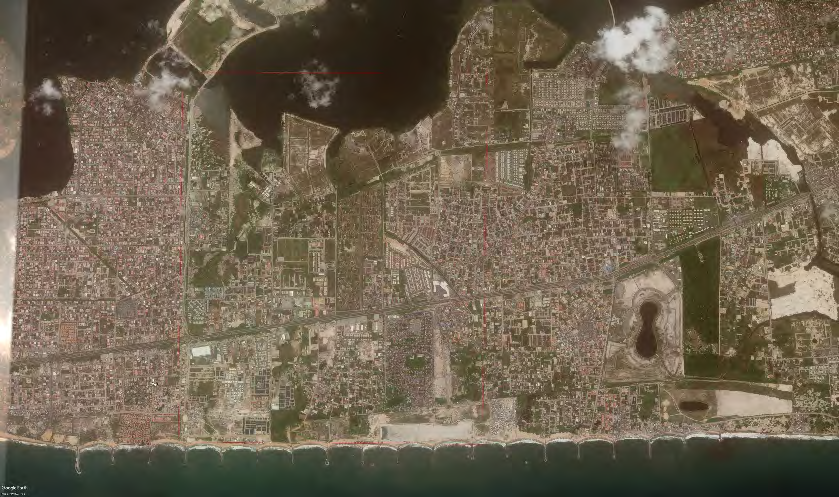
Urban development in Lagos is taking place by the conversion of coastal wetlands into urbanized communities which is a direct result of urban spraw [9]. If this rate of growth of urbanization remains, the community will be forced to confront impacts on soil erosion, biodiversity, infrastructure demands, polarized demographics, and public health. As of 1978, the city had a population of 4, 300 people (see table 3).
| Metropolitan Lagos in thousands | Implicit Annual Growth Rate percent | Non-Metropolitan Lagos in thousands | Total of Lagos State | Metropolitan Lagos as a percentage of Lagos State population | |
|---|---|---|---|---|---|
| 1978 | 3,779 | 9.3% | 521 | 4,300 | 87.88% |
| 1988 | 7,580 | 5.56% | 812 | 8,392 | 90.32% |
| 1994 | 9,975 | 4.3|% | 1,026 | 11,001 | 90.67% |
| 1998 | 11,842 | 4.48% | 1,147 | 13,039 | 90.87 |
| 200012,9494.481,2383 | 14,232 | 90.98 |
Table 3: Population of Lagos State and Metropolitan and Non-Metropolitan Lagos 1978-2000.
Source: Called from Lagos Regional Plan (1980-2000) Table 3: Population of Lagos State and Metropolitan and Non-Metropolitan Lagos 1978-2000.
Lagos experienced an influx of over 7 million people from 1990 to 2004. In 1990 the population was 7.74 million, which increased to 13.4 million in 2000, and in 2004 the population reached up to 15 million. With an urban area population of an estimated 11.7 million, Lagos is the 14th largest urban area in the world. By 2010, the population is projected to surpass 20 million [15].
From 2006-2008, the annual projected growth rate stood at 4.44%, which had a ranking of the 7th fastest growing urban area in the world [20]. The grown spatially from a traditional core settlement of about 3.85 sq km in 1881 to a metropolis of over 1,183 sq km. The metropolitan area constitutes about 33% of Lagos State, with 455 sq km [19].
Causes of Land Use Pattern in Coastal Areas of Lagos
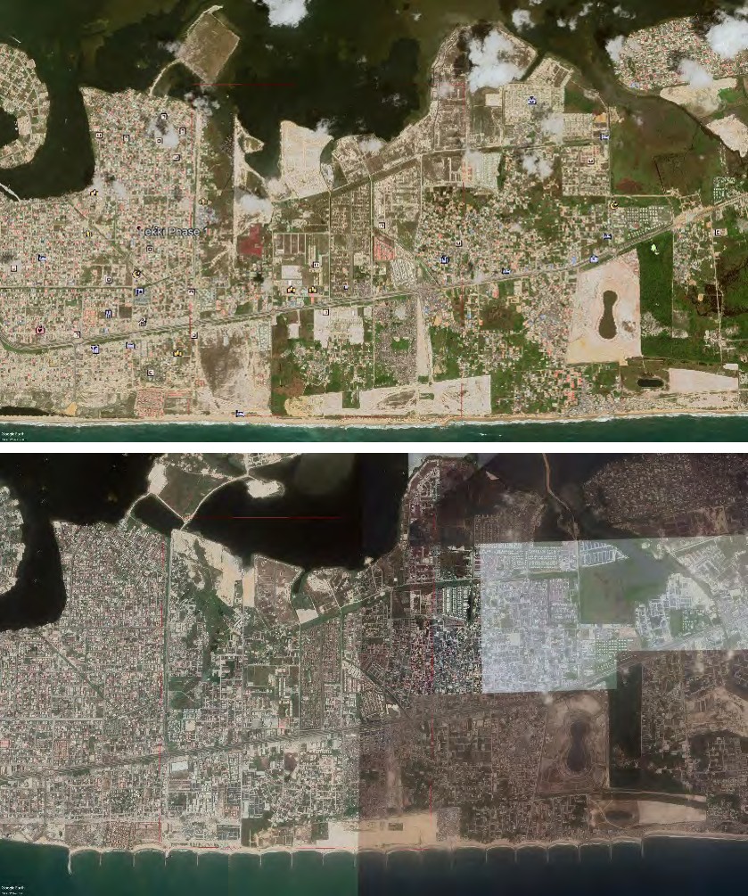
According to a World Bank Renewal Project, since 1981, the total estimated number of ‘blighted slum communities has grown from 42 to almost 100, due to a lack of social services and housing development projects [6]. Conversion from rural to urban area accounts for approximately 75% of the population growth of Lagos’ metropolitan area [15]. Between 1986 and 2002 the developed area in Lagos Coastal Area increased by 13% (from 43% in 1986 to 56% in 2002), while swampland decreased by 11% and water area decreased by 3% [20].
Patterns of Land Use in the Study Area
Considerable urban development rates and land fragmentation trends were observed in areas. This trend was confirmed by all three methods (very high confidence, Table 1). Analysis of google earth (Figure 1) shows that in the area, the built-up area increased in the period between 2011, 2017 to 2020, the number of settlement units (SUs) increased from 3.6% in 2011 to 4.7% in 2017 to 12.5% in 2020 respectively (Table 2).
Causes/Driving forces for Land Use Change in the Study Area
In general, present good roads was identified as a strong driver of urban development. This has given rise to increasing demand for settlement areas for industrial employees and workers [21, 22].
Zoning regulation was reported to be less strict, leading to mixed land uses, which were considered less desirable than separated land uses. In the study area, there is spill- overs from already congested areas were assumed to drive migration and informal urban sprawl.
Apart from roads, other infrastructural development such as electricity, schools, hospitals and water provision appears uncorrelated with urban development. Oduwaye [7] showed that in the past, the government had focused less on infrastructural development in fast-growing urban areas, which in turn caused immigration from rural areas where public services are non-existent [23].
Recommendations and Conclusion
Based on the finding of this study, it was observed that the study area is undergoing series of transformation in the pattern of land use due to informal urban expansion with small settlement units, historical development, strategic- geographical location and related economic priorities has led to a different speed and pattern of urban development in the study area. For example in the Lekki axis is faster than other parts of the state area, which is with high confidence due to its economic vibrancy and markets. The expansion of scattered large settlement units in the study area was due to economic advantage. Population growth remains an important driver of urban development with high confidence in both areas [24].
Based on the above, the following are recommended:
- Future land-use plans must be framed by firm wetland conservation strategies that discourage the disturbance of swamp habitat. Additional research must be performed to forecast the health and life expectancy of the Lagos wetlands.
- Future land use plans must take into account potential impacts on the transportation of natural resources as well as foreign trade products. sound, practical waste management regulations would decrease the rate and severity of waterway pollution, as well as the risk of exposure to toxic chemicals in drinking water and stormwater drainage.
- Smart growth would prove economically beneficial to the food market, tourism, resource consumption, and wealth diversity/equity.
- Mixed-income housing in urban areas would strive to improve city-wide quality of life.
- The implementation of equal-access housing markets, educational resources, and employment services would decrease the occupancy of low-income, informal living standards that currently have negative impacts on water quality, public health, and biodiversity.
References
-
Arunachalam S, Maharani K, Chidambaram S, Prasanna M, Manivel M (2011) A study on the Land use pattern change along the coastal region of Nagapattinam, Tamil Nadu. International journal of geomatics and geosciences 4(1): 700-720.
-
Kleemann J, Inkoom JN, Thiel M, Shankar S, Lautenbach S, Fürs C (2017) Peri-urban land use pattern and its relation to land use planning in Ghana, West Africa. Landscape Urban Plan: 1-17.
-
Zhi D, Fenzhen S, Junjue Z, Yu Z, Shuchang L, et al. (2019) Clustering Coastal Land Use Sequence Patterns along the Sea–Land Direction: A Case Study in the Coastal Zone of Bohai Bay and the Yellow River Delta, China. Remote Sensing 11(17): 1-19.
-
Jinliang H, Zhenshun T, Jie L (2009) Land-use dynamics and landscape pattern change in a coastal gulf region, southeast China. International Journal of Sustainable Development & World Ecology 16(1): 61-66.
-
African Development Bank (AfDB) (2005) Integrated urban development policy and urban development strategy paper: Revision of the african development bank group’s urban development policy and preparation of an urban development strategy paper. draft report. African Development Bank (AfDB).
-
Akinluyi FO, Adebola AO, Adeseko AA (2018) Assessment of Shoreline and Associated Landuse/Land cover Changes along Part of Lagos Coastline, Nigeria. Contemporary Trends in Geoscience 7(1): 59-71.
-
Oduwaye L (2013) Urban Planning Implications of Changing Land Use Structure of Metropolitan Lagos, Nigeria. REAL CORP 2013 Tagungsband 20-23 May 2013, Rome, Italy, pp: 1055-1065.
-
Jianzhu W, Ikechukwu NM (2018) Spatio-temporal urban growth dynamics of Lagos Metropolitan Region of Nigeria based on Hybrid methods for LULC modeling and prediction. European Journal of Remote Sensing 51(1): 251-265.
-
Dekolo SO, Dupe NO (2013) Monitoring peri-urban land use change with multi-temporal Landsat imagery. London: Conference: Urban and Regional Data Management.
-
Elias P, Dekolo S, Babatola O (2013) Land use Change Modelling in Developing Countries : Issues and Prospects. International Journal of Geography and Geology 1(1): 23-41.
-
Eresanya E, Daramola M, Durowoju O, Awoyele P (2019) Investigation of the changing patterns of the land use land cover over Osogbo and its environs. Royal Society open science 6(12): 1-12.
-
Adetunji MA, Oyeleye OI (2018) Land and use land cover change and hazard occurence along coastline of Nigeria. International Journal of Geography and Regional Planning Research 3(1): 1-8.
-
Robert JN, Susan EH, Jason AL, Richard AW, Xianfu L, et al. (2014) Sea‐level scenarios for evaluating coastal impacts. WIREs Climate Change 5(1): 129-150.
-
Adelekan I (2010) Vulnerability of poor urban coastal communities to flooding in Lagos, Nigeria. International Institute for Environment and Development 22(2): 433- 450.
-
Onilude OO, Vaz E (2020) Data Analysis of Land Use Change and Urban and Rural Impacts in Lagos State, Nigeria. MDPI data journal 5(72): 1-19.
-
Asib A (2011) Some of the major environmental problems relating to land use changes in the coastal areas of Bangladesh: A review. Journal of Geography and Regional Planning 4(1): 1-8.
-
Babalola O, Akinsanola A (2016) Change Detection in Land Surface Temperature and Land Use Land Cover over Lagos Metropolis, Nigeria. Journal of Remote Sensing GIS 5(3): 171-179.
-
Pan S, Li G, Yang Q, Ouyang Z, Lockaby G (2013) Monitoring Land-Use and Land-Cover Change in the Eastern Gulf Coastal Plain Using Multi temporal Landsat Imagery. Journal Geophysic Remote Sensing 2(1): 1-7.
-
Nwokoro II, Dekolo SO (2012) Land use change and environmental sustainability: the case of Lagos Metropolis. WIT Transactions on Ecology and The Environment 7(1): 157-167.
-
Sunday O, Ajewole A (2006) Implications of the Changing Pattern of Land cover of the Lagos Coastal Area of Nigerian. American-Eurasian Journal of Scientific Research IDOSI Publications 1(1): 31-37.
-
Adelekan I (2009) Vulnerability of Poor Urban Coastal Communities to Climate Change in Lagos, Nigeria. Fifth Urban Research Symposium. 2009 (p. nd). Ibadan, Nigeria: Department of Geography University of Ibadan.
-
Braimoha A, Onishib T (2006) Spatial determinants of urban land use change in Lagos, Nigeria. Land Use Policy 24(2): 502-515.
-
Lagos State of Nigeria (1981) Lagos State Regional Plan (1980-2000). Lagos State Secretariat, Ikeja: Ministry of Economic Planning and Land Matters, Urban and Regional Planning Division.
-
Okwuashi O, Ofem B (2014) Historical Perspective of Urbanization and Urban Planning of Lagos, Nigeria. International Journal of Science and Research 3(8): 1994-1998.
- Lessons to Learn: Trees are More than the Lungs of the World
- Community Forestry Enterprises as a Model for Sustainable Forest Development: The Case Of The "Baja Tarahumara" in Chihuahua, Mexico
- Ecological and Socio-Economic Impacts of Chromolaena odorata and Mesosphaerum suaveolens, Two Invasive Alien Species in Central and Southern Benin, West Africa
- Epigenetic Sustainability: Modeling the Human Factor as a Natural Resource through Science 4.0 and the NR3C1 Biological Pilot
- Growth-at-Risk: A Framework for Assessing Economic Vulnerability
- The Rural Territory as a Socioecological System for the Management of Public Policy for Sustainable Rural Development