Range Mapping of Brown Bears Using Sighting information in Persian Oak Forests, Western Iran
Aims: this study aims at range mapping of brown bears using sighting information in the province of Kohgiluyeh and Boyer Ahmed(K&B) in southern Zagros region, western Iran as one of the most important habitats for brown bears in Iran. Material and methods: Brown bear sightings were obtained through interviews using the snowball sampling method from mid-September to the end of September 2018 in K&B, western Iran, one of the most important habitats for brown bears. Based on this information, brown bear occurrence areas in the provinces were mapped. The created map was divided into two density categories generated buffers by the home range size of adult brown bears in a similar habitat. Findings: Overlaying the density maps produced with the land cover use maps and protected area maps, brown bears occupied approximately 38% of the total area of K&B. Forests and low-density forests occupied approximately 99.8% and 50% of bear habitat within and outside the protected areas, respectively. Protected areas accounted for only 20% of the bear habitat. Conclusion: Most of the distribution of the brown bears in K&B is situated in the woodland and low-density forests and the conservation of Persian oak forests as a habitat and food source for brown bears has an effective and major role on conservation of brown bears.
Alireza Salehi*1 and Arya Shafaeipour2
Introduction
Iran is one of the southernmost extents of distribution of brown bears (Ursus arctos) in the world [1]. The occurrence of the brown bears in Iran is restricted to the mountain forest areas of Alborz in north, Zagros in west [2, 3, 4, 5] and Caucasia in northwest [6, 7, 8]. The brown bear is the largest carnivore of Iran [1, 9, 10] and its population is at high risk. The main factors threatening the survival of this species in the region are retaliatory hunting due to attacks on gardens, beehives, and other assets of villagers; capturing of cubs for smuggling to other countries; and hunting [2, 11]. The brown bear in Iran is declared as a protected species by the Department of Environment (DoE) Gutleb B, Nezami B [2, 9] and protected areas are the core areas for brown bear conservation [2]. A protected area (PA) is defined as ‘‘a clearly defined geographical space, recognized, dedicated and managed, through legal or other effective means, to achieve the long term conservation of nature with associated ecosystem services and cultural values’’ [12, 13]. In Iran PAs are under the management and authority of DoE.
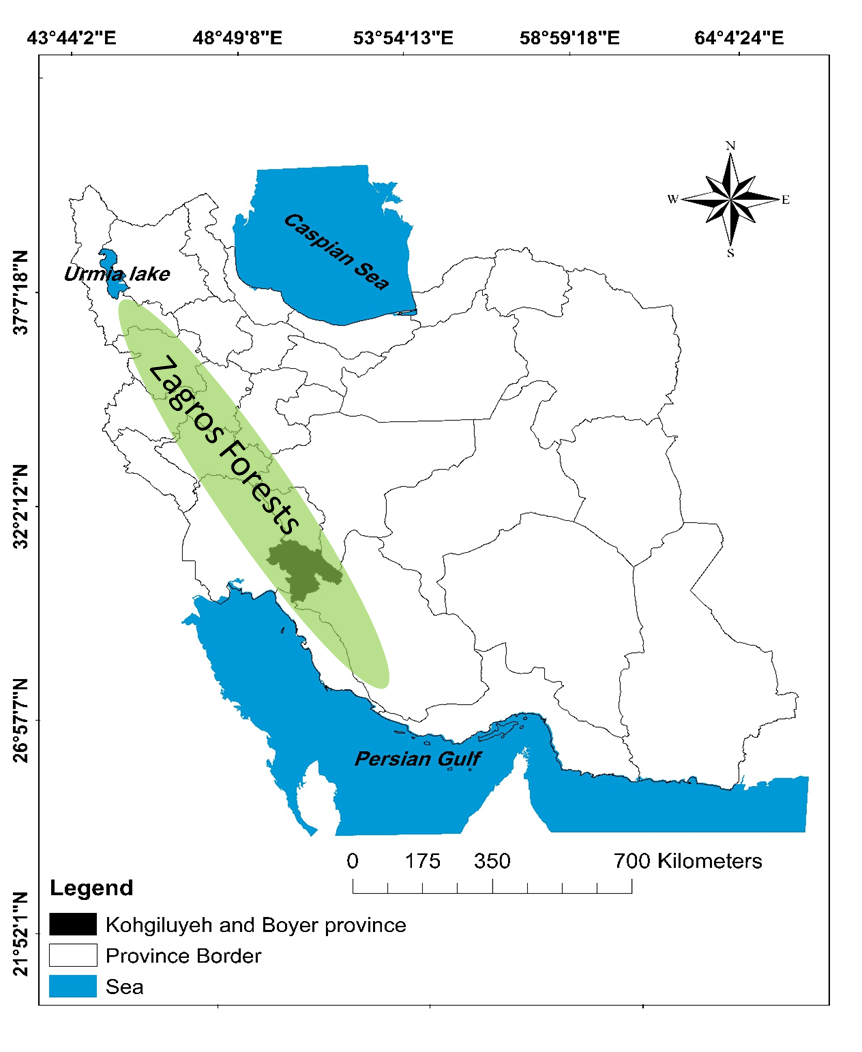
Kohgiluyeh and Boyer-Ahmad Province (hereafter K&B) with an area of approximately 16,000 km2 is located in southwest of Iran within the Zagros Mountains (including the Dena Mountains subrange) (Figure 1). Due to large available habitat in K&B, it is thought to be one of the most important areas for brown bear in Zagros region.
In this study, we will present a brown bear occurrence map to determine the distribution ranges and overlay it to protected areas, land cover and land use in the province of K&B. It will be useful to determine important areas for research, management, and protection of the species in the province as well as the Zagros region.
Material & Methods
Study Area
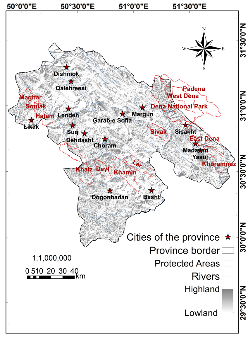
The province of K&B is located in the south-west of Iran (Figure 1) and about three-fourths of this province is mostly mountainous, part of the Zagros range, and the remainder is plains [14]. In the province of K&B, elevation, rainfall, and humidity decrease while the average temperature increases from NE to SW along the main Zagros Mountain Range; in general, this gradient creates two separate climates, cold and subtropical regions. Elevations of the province range from 4,435 m on Mount Dena to 170 m in CherehZan plain; the annual precipitation in this region varies between 300 mm and approximately 1000 mm and its annual average temperature varies of 11°C in cold regions up to 21°C subtropical regions [15].
Various types of forest including of 7% dense forests, 29% semi-dense forests, 53% sparse forests, 9% shrublands, and 2% hand-planted forests cover about 53% of the total area of the province of K&B. This forest area makes up about 20% of the forest cover in Zagros, the highest share of any Zagrosian province [16]. The main woody species of these forests are Quercus brantii, Q. infectoria, Q.libani, Amygdalus scoparia, Pistacia mutica (P. khinjuk), Acer cinerasence, Crategus spp, Cerasus spp and Pyrus spp. [15, 17, 18, 19]. There are seven protected areas (PAs) in K&B: Western Dena, Eastern Dena, Khaeiz - Sorkh, Khamin, Sivak, Deyl and Soulak, four no hunting areas: Maghar, Hatam, Lar, Khoramnaz and one national park: Dena national park. Surface of PAs span between 940 km2 and 25km2 (Figure 2).
Methods
To create a map of relative density of presence of brown bears in the province of K&B, the seven following steps were conducted; 1) a clearly visible, 1: 250,000 map of the province was provided by GIS software and printed. The printed map displayed the borders of the counties, names of the villages and the layers of the land use-cover, hilshades, roads, rivers, main streams and the PAs of the province. The data layers for producing the 1: 250,000 map were obtained from DoE of the province. DoE provided these data layers in 2008. 2) Informative people who were aware about the presence of brown bears in different parts of the province were identified for interview. 3) The objectives of this study were explained to the interviewees and their final opinion about the presence only of brown bears in different parts of the study area were marked on the printed map. 4) The distincted and marked points of visual sightings of the brown bears on the printed map were transferred into a GIS map. 5) Two home range sizes of female and male brown bears were defined as two assigned distances to explain, respectively, the high and low relative density of the occurrence of the brown bears in the province. 6) The defined home range sizes were used as radii to buffer the marked points by ArcMap 10.7.1 to create the high and low relative density maps for presence of the brown bears in the region. 7) To investigate the conservation status of the brown bears in the province of K&B, the map of the relative density of the presence of the brown bears in the province were overlaid and compared with vector maps of PAs and land cover-use of the province.
Data collection was accomplished from the Mid- September to the end of 2018. The exponential non- discriminative snowball sampling (chain-referral sampling) method Goodman LA [20] was used to find the interviewees who were aware about the presence of the brown bears in different parts of the province. The snowball sampling method is extensively used where a population is unknown and rare and it is tough to choose subjects to assemble them as samples for research. In snowball sampling method, the first subject is recruited and then he/she provides multiple referrals; Each new referral then provides with more data for referral and so on [21]. In snowball sampling technique, samples are selected based on the subjective judgment of the researcher rather than random selection and there is a fear of sampling bias when this technique is used; this sampling method depends heavily on the expertise of the researchers [22]. The extent of distribution of the sample points in the printed map of the province, consideration to the historical reports of ranger stations about observation of brown bears in different parts of the province and consulting with experienced rangers could be an enough proof for consistency of the sampling throughout the area. Annual reports from ranger stations of each county of the province of K&B about wildlife observations and individuals who observed the brown bears during the 2016 to 2018 were the starting points (the first respondents) for the snowball method sampling. Each ranger station is responsible for a patrol section within the study area.
In total 96 points for observations of the brown bears were reported and marked on the printed map by 35 interviewees. The interviews were completed during one month by the end of autumn 2018. Efforts were made to meet and interview all addressed interviewees in the region and the respondents were asked to mark their observations on the printed map only of sightings of the adult brown bears during the last three years between 2016 and 2018. The cubs and the sex of the bears were not considered. In each interview, to avoid duplication of markings in a specified area some information about the marked points including time of the observations of the bears and the profiles of the former respondents were explained to each respondent. The respondents were all male with an age range between 25 to 70 years old, with different professions consist of rangers and individuals of the environmental protection guard of the province’s DoE (22 persons), local villagers (six persons), gardeners (three persons), ranchers (two persons), and members of the environmental NGOs (two persons). The most of the respondents (around 60%) were inhabitants of the villages either in edge or within the PAs and the rest were from villages out of PAs and even cities (one case). Some of the respondents had marked their observations more than one points on the map. All of the respondents with multiple observations were rangers or members of the environmental protection guard. Three rangers contributed the most observations [4, 19] since they had a lot of experience (in years) patrolling in PAs and areas outside of PAs and were experienced with maps.
The primary point data obtained was converted to areal information by drawing a buffer of the radius of the brown bear’s home range size, approximated by a circle around the point data to use as the distribution area map. Reliable data on the size of brown bear home ranges in Iran do not exist. Therefore, we referred the home range size of adult brown bears (≥3 years old) in the Caucasus and southeastern Europe [8], which habitat would be similar to that of the study area. Two types of buffers around the marker point with a radius of 5020 m (female home range: 79.2 km2) and 13077 m (male home range: 537.3 km2) were generated to create a distribution map, considering that the former being the area of relative high-density area and the latter being the low- density area. To study the spatial distribution of the brown bears in land cover- use types in the province, the two maps of high and low densities of the presence of the brown bears were overlaid on a vector land cover- use map of the study area. Then, the relative density of the occupied brown bear habitats in the province were compared with land cover- use map of the province.
Findings
Table 1 depicts the numbers of observed brown bears by the respondents. The highest number of the observed brown bears (21) (Table 1) was reported by a member of the environmental protection guard, who had a good enough skill in working with maps from different parts of Dena region. The reported observation times were mostly in the end of the summers or the beginning of the autumns (14 cases) for all the three years of data collection period.
| N. of the observed brown bears | N. of respondents | Sum |
|---|---|---|
| 1 | 13 | 13 |
| 2 | 12 | 24 |
| 3 | 6 | 18 |
| 4 | 1 | 4 |
| 5 | 1 | 5 |
| 11 | 1 | 11 |
| 21 | 1 | 21 |
| Total of the marked points | 96 |
Table 1: The frequency table of observed brown bears by respondents in different parts of the province during 2016 to 2018.
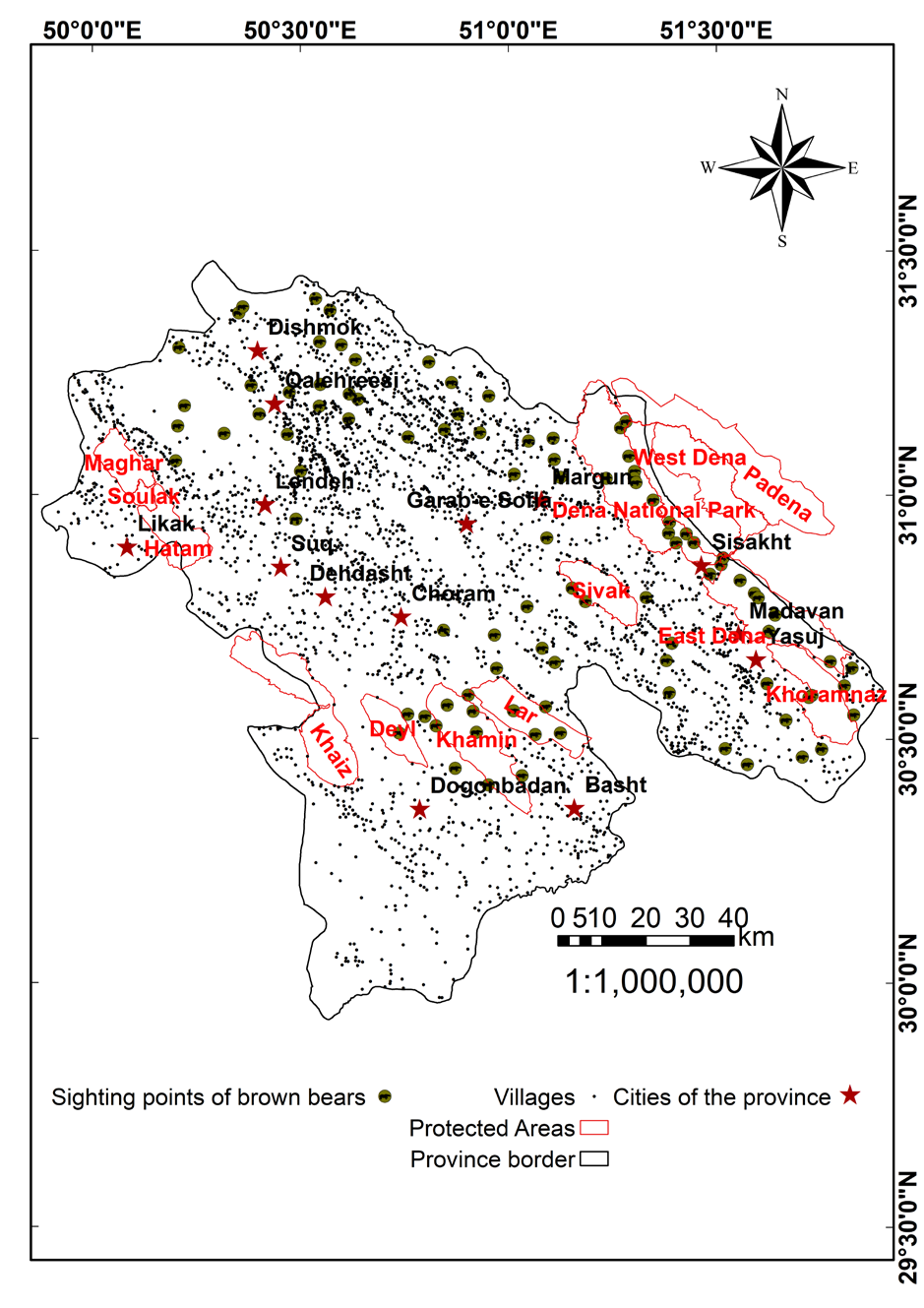
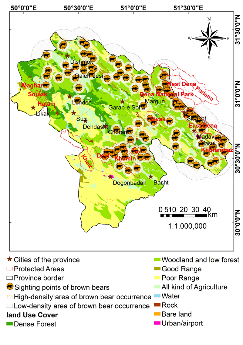
Figure 4: The ranges of brown bears in two levels of high and low density in different land covers-uses of the province of Kohgiluyeh and Boyer-Ahmad. Good range (rangeland) and poor rang (rangeland) are two combined terms issued by evaluation of different ecological factors such as type of plants, density of vegetation covers and soil characteristics, based upon the Iranian range evaluation model.
Figure 3 shows the distribution map of the sighting points of the brown bears in the province. Most of the observation points of the brown bears were located in the north, northeast, and the east of the province (Figure 3). Only 29 out of the 96 sighting points (30%) are located in PAs (30 %), while the bears also could be found widely in the areas out of the management (protection) of DoE. Western and Eastern Dena protected areas and Dena National Park located in the northeast part of the province have the most quota of this portion (20 observations).
The map of the bear sightings in two classes of high and low density was overlayed on the land cover-use map of the province (Figure 4). The high density map of brown bears occupied approximately 38% of the total area of the province, while only about 20% of this extent is located within PAs, this means that, the extending range of brown bears in the province is much more than the extent of PAs (Figure 4). The ranges of brown bears in different land covers and land uses are compared in table 2 for PAs and the areas out of PAs. The majority of bear range in PAs is located in woodland and low- density forests (99.8%) (Table 2). In the areas out of PAs, after woodlands and low forests (49.6%), poor rangelands (18.9%) and all kind of agricultural activities (15.7%) are respectively most common land-cover types associated with the bear range (Table 2).
| Land use- cover | Protected areas | Out of the protected areas | ||||
|---|---|---|---|---|---|---|
| N. of land use patches | Area (ha) | % | N. of land use patches | Area (ha) | % | |
| Woodland/ low forest | 5 | 32800 | 99.8 | 91 | 211648 | 49.6 |
| Poor Range | 0 | 0 | 0.0 | 150 | 80658 | 18.9 |
| All kind of Agriculture | 6 | 21 | 0.1 | 231 | 66914 | 15.7 |
| Dense Forest | 0 | 0 | 0.0 | 55 | 44475 | 10.4 |
| Good Range | 0 | 0.0 | 0.0 | 36 | 20165 | 4.7 |
| Rock | 2 | 47 | 0.1 | 10 | 1222 | 0.3 |
| Residential | 0 | 0 | 0.0 | 11 | 754 | 0.2 |
| Bare land | 0 | 0 | 0.0 | 7 | 528 | 0.1 |
| Sum | 13 | 32868 | 100 | 591 | 426364 | 100 |
Table 2: Comparison of the areas (ha) and numbers of land cover- use patches located in the high density range of brown bears in
According to the information obtained from the interviews, the residential and rural areas located in Dena Protected Area and the outskirts of Dena National Park have the highest claims (five cases) of bear damages on gardens, domestic livestock, honey hives, fish farms and agricultural lands.
Discussion
The presented map in Figure 4 could be used as a thematic map for conducting more comprehensive and detailed studies about occurrence of brown bears and their home range sizes in the province. The map of distribution of the sighting points of the brown bears in K&B shows a good agreement with the map of distribution of the dense and semi-dense Persian oak forests in the mainly mountainous areas of the province (Figure 4). The mismatching between PAs and the identified range for brown bears could be as an obstacle for protection of brown bears in K&B Province.
No reports were received about the presence of brown bears in the south and west parts of the province, where a subtropical climate is dominated. As found by Parchizadeh J, et al. [14], his respondents did not report any observation of brown bears in the protected areas of Khaeiz – Sorkh, Deyl and Soulak located in the west of the province, but unlike [14], we received a single report of the presence of brown bear in the protected area of Deyl.
The majority of bear range in PAs is located in woodland and low-density forests and Persian oak is the dominant woody species of these forests [17]. Thus, as the main habitat for brown bears, conservation of Persian oak forests could have an important role on conservation of brown bears in the province. Carnivorous mammals are a key to the health and species richness of ecosystems and play a key role in the biodiversity of ecosystems [23]. Brown bears as the largest carnivores in the Zagros region play a role of an umbrella species and could be considered as key species indicating the conservation status of its habitats [24, 25]. Oak forests, in addition to providing habitat for the brown bears, provide habitats for other animals that brown bears feed on them. Moreover, oak trees provide an important food for bears by producing hard mast (acorns) [26, 27]. Reporting the bear sightings in autumn were possibly because of bear searching for fall foods.
By feeding on insects, worms and larvae in the roots and trunks of trees, bears contribute to forest health and support of these forests [26]. Cavities in the trunks of old trees also provide a safe place for the animal to hibernate; Also, bears scatter seeds and thus play a role in sowing plants and helping maintain the genetic diversity of the species [24, 26]. Mohammadi A [28] mention that forest density is one of the most influential variables for the habitat of brown bears.
Kernel Density Estimation (KDE) technique Silverman BW [29] in ArcGIS could be used to estimate a home range size of the brown bears Adjaye TA, Pop IM [30, 31] and Persian leopard [32]. Nevertheless, the home range sizes of 79.2 km2 and 537.3 km2 as the home range sizes of female and male brown bears, respectively, were preferred. This preference was considered firstly because a relative similarity of brown bear habitat in Caucasus region in northwest of Iran with its habitat conditions in Zagros [3, 4, 5]. Secondly, producing a density map by KDE technique covers a large extent of the region, including many villages and roads that does not correspond to the reality.
This study is a cursory first look at where brown bears may be distributed in the province of K&B and it is possible that multiple observation points could be the same individual brown bears. In a study from the Romanian Eastern Carpathians, using the 95% minimum convex polygon method, [31] suggested for a home range size of brown bears (~630 km2) that is larger than the used home range size in this study (537 km2). Many environmental factors such as terrain and topographic condition, forest type, accessibility to water and food source, road and residence could influence on the home range size of the brown bears [31]. The study of Moqanaki EM, et al. [8] to estimate bear density in Arasbaran Biosphere Reserve and comparing the results with rangers’ perceptions as collated through interviews, shows that the perceived abundance of bears by local rangers was between 3 and 5 times higher than their applied method to estimate the population of bears in the study area. There is a need for the further research to better quantify the home range size, number and distribution of brown bears in the area by using relevant technologies e.g. motion-activated wildlife cameras or hair snares to obtain DNA samples [4, 8].
The bear damages reported in this study also were reported in the province of K&B by Parchizadeh [14, 33], these kinds of damages also reported from Fars province, in the eastern adjacent of K&B Province [4].
Due to the growing trend of economic and social development such as construction of roads, power lines, gas pipelines, dams etc. and a lack of a proper supervision and control on sustainable development of the region, the survival of brown bears is under threatened. Fragmentation of brown bear home ranges by agricultural lands in the region could be interpreted as a clear sign of human encroachment on territory of the brown bears. To decrease the negative impact of human-wildlife interactions and to achieve a sustainable conservation and management on wildlife, having a participatory conservation in context of an adaptive management on forests and brown bears by inhabitants and wildlife management sector is needed [34].
Conclusion
The survival of the brown bear population in K&B province is at risk. K&B could be considered as one of important habitats for this at risk animal species in Zagros region in Iran. Most of the distribution of the brown bears in the province is situated in the woodland and low-density forests. Therefore, the conservation of Persian oak forests as a habitat and food source for brown bears has an effective and major role on conservation of this species. The mismatching between PAs and areas identified as being occupied by the brown bears could be an obstacle for conservation of the brown bears in the province. To enhance conservation of the brown bears, engagement of local residents to conservation of oak forests and brown bears is needed. This study is a rough estimation about the distribution of brown bears and a relative density of their occurrence in the province. To have a better conservation on brown bears in the province, more accurate and precise researches about these issues are needed.
Acknowledgements
I am grateful to Mr. Pakbaz and Mr. Hosainpoor, the staffs from the bureau of natural environment of Department of Environment of the Province of Kohgiluyeh and Boyer- Ahmad, for their helpful helps in data collection for the project of ‘’Conservation of brown bear to manage protection of the under risk species’’. This paper used some parts of these collected data. None declared by Authors.
Ethical permissions: The authors of this study approve sending it to ECOPERSIA journal and declare that this study is not un-der revision in any other scholarly journals at the time of submission to the journal and will not be sent to any other scholarly journal during the revision at the journal until the definite answer about it. The authors chose Dr. Alireza Salehi (the first author) as the corresponding author and delegated all the responsibility of the article to his regarding following the relation with ECOPERSIA.
Conflicts of Interest: The authors declare that there is no Conflict of Interest regarding the publication of this study.
Authors’ Contribution: Alireza Salehi (First author), Introduction author/ data analysis and Methodologist/ Original researcher/Findings and Discussion author (75%); Arya Shafaeipour (Second author), Methodologist and Discussion author (25%).
Funding/Support: There is no financial support for this manuscript.
References
-
Ansari M, Ghoddousi A (2018) Water availability limits brown bear distribution at the southern edge of its global range. Ursus 29(1): 13-24.
-
Gutleb B, Ziaie H (1999) On the distribution and status of the Brown Bear, Ursus arctos, and the Asiatic Black Bear, U. Tibetans, in Iran. Zool Middle East 18(1): 5-8.
-
Karami P., Shayesteh K, Esmaeili M (2019) Investigation of Brown Bear (Ursus arctos Linnaeus, 1758) Distribution in the Sephid-Koh protected area of Lorestan Province. J Anim Environ 11(2): 1-10.
-
Gholamhosseini A, Ansari M, Ebrahimi M, Esmaeili HR (2020) Using signs to Document the Distribution of Brown Bear, Ursus arctos (Linneaus, 1758), Kind of Damages and Conflict with Humans in Fars Province, Southern Iran. Exp Anim Biol 8(3): 111-119.
-
Hosseini SP, Jafari R, Esfahani MT, Senn J, Hemami MR, et al. (2021) Investigating habitat degradation of Ursus arctos using species distribution modelling and remote sensing in Zagros Mountains of Iran. Arab J Geosci 14(21): 2179.
-
Moqanaki EM, Bensch S (2014) Assessing the status of Syrian brown bears in the Iranian Caucasus: research for conservation.
-
Nezami B, Eagdari S, Barkhor M, Sasanfar Z (2014) Sexual dimorphism of Cranial shape in Iranian Brown Bear Ursus arctos Linnaeus, 1758 using Geometric Morphometric approach. Bull Env Pharmacol 3(3): 329- 335.
-
Moqanaki EM, Jiménez J, Bensch S, López-Bao JV (2018) Counting bears in the Iranian Caucasus: remarkable mismatch between scientifically-sound population estimates and perceptions. Biol Conserv 220: 182-191.
-
Nezami B, Farhadinia M (2011) Litter sizes of brown bears in the Central Alborz Protected Area, Iran. Ursus 22(2): 167-171.
-
Hosseini SP, Amiri M, Senn J (2022) The effect of environmental and human factors on the distribution of Brown bear (Ursus arctos isabellinus) in Iran. Appl Ecol Environ Res 20(1): 153-70.
-
Qashqaei AT, Karami M, Etemad V (2014) Wildlife conflicts between humans and Brown Bears, Ursus arctos, in the Central Zagros, Iran. Zool Middle East 60(2): 107-110.
-
Dudley N (2005) Towards effective protected area systems: An action guide to implement the Convention on Biological Diversity Programme of Work on Protected Areas.
-
Kolahi M, Sakai T, Moriya K, Makhdoum MF (2012) Challenges to the future development of Iran’s protected areas system. Environ Manag 50(4): 750-765.
-
Parchizadeh J (2017) A Quick Survey of Brown Bears in Kohgiluyeh and Boyer-Ahmad Province, Southwestern Iran. Int Bear News 26(2): 24-25.
-
Jazirehi MH, Ebrahimi M (2003) Silviculture in Zagros, 1 edition, University of Tehran Press.
-
FRWMO (2001) Forest database of natural resources management Headquarter of K&B, Iran.
-
Sagheb-Talebi K, Sajedi T, Yazdian F (2004) Forest of Iran. R.I.F.R. Iran.
-
Menitsky YL, Fedorov AA, Komarova VL (2005) Oaks of Asia (NH. Enfield). Scie. Publish.
-
Panahi P, Jamzad Z, Pourmajidian MR, Fallah A (2014) Taxonomic revision of the Quercus brantii complex (Fagaceae) in Iran with emphasis on leaf and pollen micromorphology, Acta Bot Hung 54(4): 355-375.
-
Goodman LA (1961) Snowball sampling. Ann Math Stat 31(1): 148-170.
-
Brace-Govan JV (2004) Issues in snowball sampling: the lawyer, the model and ethics. Qualit Res J 4(1): 52-60.
-
Basu S (2020) Do you know any sample size calculation for nonprobability (snwoball) sampling technique?
-
Sergio F, Caro T, Brown D, Clucas B, Hunter J, et al. (2008) Top predators as conservation tools: ecological rationale, assumptions, and efficacy. Annu Rev Ecol Evol Syst 29: 1-19.
-
Kanellopoulos NI, Mertzanis GE, Korakis GE, Panagiotopoulou MA (2006) Selective habitat use by brown bear (Ursus arctos L.) in northern Pindos, Greece. J Biol Res 5: 23-33.
-
Zarei A, Mahmodi M, Hosinzade MH, Bandali M, Mahmodi F (2017) To survey factors influencing the spatial and temporal ecological niche brown bear (Ursus arctos syriacus) on the southern edge of its distribution range in Fars province. J Anim Environ 9(1): 39-48.
-
Pasitschniak-Arts M (993) Important food for bears. 439: 1-10.
-
Johnson PS (1994) How to manage oak forests for acorn production. US Department of Agriculture, Forest Service, NCFES.
-
Mohammadi A, Almasieh K, Nayeri D, Ataei F, Khani A, et al. (2021) Identifying priority core habitats and corridors for effective conservation of brown bears in Iran. Sci rep 11(1): 1-3.
-
Silverman BW (1986) Density Estimation for Statistics and Data Analysis. New York: Chapman and Hall.
-
Adjaye TA (2011) Maxent modelling of the apennine brown bear using incidental presence records: a comparison of raw records and a kernel density in southern Majella NP (Master’s thesis, University of Twente).
-
Pop IM, Bereczky L, Chiriac S, Iosif R, Nita A, et al. (2018) Movement ecology of brown bears (Ursus arctos) in the Romanian Eastern Carpathians. Nat Conserv 26: 15-31.
-
Moradi AS, Ahmadi A, Toranjzar H, Shams-Esfandabad B (2022) Modeling the habitat suitability of Persian Leopard (Panthera Pardus Saxicolor) in the conservation areas of Kohkiloye-and-Boyer-Ahmad, Iran. ECOPERSIA 10(2):109-119.
-
Parchizadeh J, Belant JL (2021) Brown bear and Persian leopard attacks on humans in Iran. PloS one 16(7): e0255042.
-
Pătru-Stupariu I, Nita A, Mustăţea M, Huzui-Stoiculescu A, Fürst C (2020) Using social network methodological approach to better understand human–wildlife interactions. Land Use Policy 99: 105009.
- Lessons to Learn: Trees are More than the Lungs of the World
- Community Forestry Enterprises as a Model for Sustainable Forest Development: The Case Of The "Baja Tarahumara" in Chihuahua, Mexico
- Ecological and Socio-Economic Impacts of Chromolaena odorata and Mesosphaerum suaveolens, Two Invasive Alien Species in Central and Southern Benin, West Africa
- Epigenetic Sustainability: Modeling the Human Factor as a Natural Resource through Science 4.0 and the NR3C1 Biological Pilot
- Growth-at-Risk: A Framework for Assessing Economic Vulnerability
- The Rural Territory as a Socioecological System for the Management of Public Policy for Sustainable Rural Development