A Contribution to the History and Paleobiology of Harput/Elazığ Türkiye and Its Surroundings
The brief history of the development of Harput and its surroundings is discussed. Harput, which also controls the Chalcolithic settlement areas, includes settlements comprising both the villages of the Altınova and Baskil regions. The rich mineral resources of the region attracted the attention of many neighbouring countries as early as the Neolithic period. This must have been the reason why Harput and its surroundings were subjected to numerous invasions throughout history. In addition, it was one of the most important centres for agricultural activities such as farming and livestock breeding in Eastern Anatolia since early times. The importance of Harput during this period and the reasons for its dominant position in the region it encompasses are well known. During this period, Harput was also an important military and commercial centre. In addition, the town is located on the most important road connection of the past era. For these and similar reasons, the city has attracted the attention of various powers in each era and has been the subject of various sieges. In the process, nearly fifty civilisations settled in the region. Surface and deep explorations of the important hills of the region, which are inundated by the Keban and Karakaya reservoirs, are also significant for the history of Harput. By analysing some of the data obtained from these excavations, an attempt has also been made to determine the palaeobiological values of the region. Important findings and opinions are presented with regard to the historical significance of Harput and the relief of Harput, which bears the traces of a lived culture.
Introduction
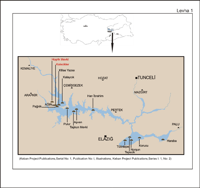
One of the oldest settlements in the region of Eastern Anatolia is Harput and its surroundings [1, 2, 3, 4]. Settlement in this region has been shown to date back to the Neolithic period (Maps 1 and 2) [5, 6, 7]. Göbekli Tepe and Nevali Çori, which are adjacent to this region, were established 12-13 thousand years ago as a resting place for the oldest settlers in human history with the end of the last Ice Age and the beginning of the Warm Period [8, 9, 10, 11, 12, 13]. There are many social, demographic, i.e. population characteristics of Harput and its surroundings, Chalcolithic and Early Bronze Age of Eastern Anatolia, Harput and its region in the Early Iron Age, its geographical structure and historical geography, historical, religious and other issues related to general and specific periods [1, 2, 3, 4, 14, 15, 16, 17, 18, 19, 20]. In this study, some information is given to contribute to the biodiversity of Harput and its surroundings in the historical process. Thanks to the archaeological rescue excavations before the construction of the Keban and Karakaya dams, the most important investments in the region, very important historical information was oktakinde [21, 22, 23, 24, 25]. Thus, the fact was uncovered that the history of Harput and its surroundings goes back to the time before the known period [26, 27, 28, 29, 30, 31].
![Figure 1: The horse at the entrance gate of the city, holding the entrance gate of the city, indicates the importance attributed to the horse. The Harput Relief is 2.72 metres high and 2.25 metres wide and is divided into five parts. It is in Elazığ Archaeological and Ethnographic Museum. The Harput Relief and the epic narrative with elements of imagery; the resistance and capture of the attackers who used a tower that could move with wheels to overcome the city walls and capture the city [31,103].](/fulltextimages/13938/fig_1.jpeg)
Map 1: The core region where the Neolithic lifestyle was formed, from [5].
Map 2: Main Neolithic sites researched in Türkiye, from [5].
Examples of the first settlements in Anatolia
The Neolithic period is a period roughly between 10 000 and 5 800 BC. It is divided into three periods. The ceramic- free Neolithic period is dated to between 10 000 and 7 000 BC. This period is divided into three sub-phases: A, B and C. Between 7 000 BC and 5 800 BC lies the pottery-free Neolithic (New Stone Age). The Harput/Elazığ, Palu, Bingöl and Malatya plains on the north side of the southeastern Taurus arc and above 800-1000 m are also part of the Neolithic Formation Zone (Map 1). In other words: Not only plains and mountain slopes, but also high-altitude areas can be included in the Neolithic settlement region. The excavations at Caferhöyük and Çayönü in the Kharpert geography include the first finds of rectangular architecture of the Pottery Neolithic Period-B (7600-7200 BC), as well as the advances in growth, relief and craftsmanship during the transition from the Pottery Neolithic Period-A to the Pottery Neolithic Period-B. Pottery Neolithic - Middle Period (7200-6500 BC) [12, 13, 30, 32, 33, 34, 35, 36, 37, 38, 39, 40].
Both in Göbekli Tepe and in the surrounding areas, a very complex social construction, a settlement order, is not the beginning of a new development. For in this geography there may have been a long period of development and a way of life with rules and principles. Only 5 per cent of the archaeological site of Göbekli Tepe has been uncovered (oral report by Prof. Schmidt). This site also shows the evolutionary change of the oldest settlement in the world. Human communities living within a radius of 200-300 km came to this great settlement to perform their religious rituals. The people who built and used it must have lived in periods that can be dated much earlier [8, 9, 10, 12, 13, 36, 41].
Sites such as Cafer Höyük (Malatya), Boytepe (Elazig) and Çınaz III (Elazig) in the geography of Harput and its surroundings have proven that the view that the Neolithic period was not suitable for hunter-gatherers and the first agricultural communities to live due to harsh winters is not correct [36]. Moreover, it is found that the highest number of settlements in the pottery-free Neolithic period is 38 per cent in the Southeast Anatolia region and 10 per cent in the East Anatolia region, including Harput. In other words, despite the steep geography and harsh climate in Eastern Anatolia, settlements have been found there [30, 34, 36]. Harput is also a region with similar climatic effects. New systematic, deep archaeological excavations being carried out here may lead to much new information. Cafer Höyük and Çayönü are near Malatya and Çınaz III is in Elazığ. The data obtained at these sites, especially the rock paintings, prove that agriculture and agricultural production were practised in these regions. In particular, the Çınaz III mound can be dated to layer B of the pottery-free Neolithic. This could date the history of Harput to 7600-7200 BC [5, 35, 42, 43, 44].
The excavations at Makaraztepe in the Tepecik village of Elazig led to the dating of the site to the end of the Old Hittite period and the beginning of the Middle Hittite period [42, 43, 45, 46]. Various Hittite finds have also been made in İmikuşağı, Tülintepe [47, 48, 49] and Korucutepe [50] near Aşağı İçme, providing important information about the history of the region [39, 51, 52, 53]. As can be seen in Map 3, Chalcolithic layers were found during the rescue excavations in the region of the Keban and Karakaya reservoirs. These are Norşuntepe, Tepecik, Pulur (Sakyol), Han İbrahim Şah, Kamikli, Gemibaşı Maltepe, Habibuşağı, Körtepe, Üyücektepe, Şentepe, İmikuşağı, Şemsiyetepe, Korucutepe, Değirmentepe and Ağın Kalaycık [36, 54, 55, 56, 57, 58, 59, 60, 61, 62, 63, 64, 65, 66, 67, 68]. The district of Maden in the geography of Harput is rich in copper mines. Copper was mined as early as 7000 BC [69].
Map 3: Keban Project excavation locations map from [5].
The C14 analyses of excavated objects from Çayönü, one of the settlements in the region, show that the natural copper and metal industry dates back to 7250-6750 BC [36, 70, 71]. The excavations at Tulintepe, dated to the end of 6000 BC, found copper slag, filings and ingots, as well as furnaces, crucibles and moulds in which they were smelted [72, 73, 74]. This proves that metal smelting techniques were known in this region. Information was given about the Karaz culture in and around Harput, as well as about the civilisations that lived in the different eras [6, 7, 69, 75, 76, 77, 78, 79, 80, 81, 82, 83].
Palaeobiological Diversity of Harput and its Surroundings
The analysis of the remains of prehistoric, Myocene mammals from the Muğla-Yatağan Formation and the animal reliefs depicted on the obelisks at Göbeklitepe, for example, are related to the richness of hunting in the strata of society that were hunters. In this context, all kinds of insects, scorpions, reptiles, birds (goose and crane figures) and predators provide valuable information about the biodiversity of that time [5, 69]. These creatures, very realistically rendered in relief, have survived to this day and give us important clues about the ecosystem of the time. This is an indication that even in prehistoric times people developed a belief system centred on “nature” [10, 11, 12, 13, 84]. In the excavations in Harput and the surrounding area, wheat, millet, lentils, barley and grapes stand out as specific cereal finds from the Chalcolithic period.
The excavations in Tepecik also yielded records of food culture. Bones of domestic animals such as cattle, sheep, goats, pigs, dogs and donkeys were found during the excavations carried out between 1970 and 1973 [5]. In the excavations at Pulur in the Harput region, representations of birds of prey, snakes, deer and turtles, symbols of goddesses and gods, which are rare in Anatolia, were found. Besides bones of domestic animals such as cattle, sheep and goats, bones of wild animals such as deer, wild sheep, wild goats, wild horses, lions and bears were also found. Most of the animal bones found at Körtepe are from domestic animals and a few from wild animals. However, the remains of wild animals recovered from other mounds of Altinova are more diverse and widespread [21, 22, 23, 24, 25, 47, 63, 72, 85, 86].
During the excavations carried out as part of the rescue work at Keban Dam, more remains of wild animals have been found than in other settlements in the region. This fact gives important clues about the biodiversity in this geographical structure. Accordingly, the following vertebrate classes (Vertebrata) were found during the evaluation of the skeletal remains in the region.
A-Mammals (Mammalia)
• Rabbits (Lagomorpha): I-Rabbits (Leporidae): a-Rabbits (Lepus europaeus) • Rodentia: I-Squirrel family (Sciuridae): a-Squirrel (Sciurus anomalus); II-Beaver family (Castoridae): a-Beaver (Castorfiber); • Predators (Carnivora): I-Dogaceae (Canidae): a- Wolf (Canis lupus); b- Red fox (Vulpes vulpes); III-Sansaraceae (Mustelidae): a- Weasel (Mustela nivalis); III-Bearaceae (Ursidae): a- Bear (Ursus arctos); IV-Hyenas (Hyaenidae): a- Striped hyena (Hyaena hyaena); V-Feline (Felidae): a- Wild cat (Felis silvestris); b- Anatolian panther (Panthera pardus tulliana); • Dual ungulates (Artodactyla): I-Pigs (Suidae): a- Wild boar (Sus scrofa); II-Deer (Cervidae): a- Red deer (Cervus elaphus), the most common species; b- Fallow deer (Dama dama); c- Roe deer (Capreolus capreolus); III- Horned deer (Bovidae): a- Wild goat (Capra aegagrus); b- Wild sheep (Ovis gmelini anadolica); c- Wild cattle (Bos primigenius); d- Wild ox (Bos taurus); e- Bison (Bison bonasus).
B- Birds (Aves)
1. Nonpasserine birds (Nonpasseres):
I-Anseridae: a-Greylag Goose (Anser anser), b- Mallard (Anas plathyrhynchos); II-Raptors (Accipitridae): a- Long- legged Buzzard (Buteo rufinus); III- Phasianidae: a- Chukar Partridge (Alectoris chukar); IV- Otididae: a- Great Bustard (Otis tarda); V-Strigidae: a- Eurasien Eagle Owl (Bubo bubo); VI- Columbidae: a-Rock Pigeon (Columba livia); b-Eurasien Collared Dove (Streptopelia decaocta)
2. Passerine birds (Passeres):
I-Crows (Corvidae): a-Elster (Pica pica), b- Eurasien Jackdaw (Coleus monedula); c- Carrion Crow (Corvus corone); II-Old World Sparrows (Passeridae): a- House Sparrow (Passer domesticus); III-Starlings (Sturnidae): a- (Sturnus vulgaris)
C- Reptiles (Reptilia)
1. Tortoises (Testudinidae): a- Tortoise (Testudo graeca) The remains of these species provide important information on the biodiversity of the region.
The excavations at the settlement of Ergani Çayönü, which has similar characteristics to the geography of Harput and is considered an example of the transition to the first production activities, have revealed that the bones of red deer (Cervus elaphus), which were found in large numbers in four of the five layers, date to around 7400-6600 BC. This indicates that the settlement in question was forested at that time [22]. Although these archaeozoological and palynological results seem to contradict each other, the faunal data obtained from the salvage excavations in Altınova, which will be flooded by the Keban Dam, were evaluated in accordance with the surface formation and climate of that time [24]. The results of the faunal data from the rescue excavations of the settlements that will be flooded under the waters of the Keban Dam are in complete and accurate agreement with the surface formations and climate of the region in question [22, 23]. Small number of partridges (Otis tarda) indicates the existence of steppe areas in Altinova since the Chalcolithic period and also today. The area where the Chalcolithic partridge bones were found is a sparse and degraded oak lowland forest, which has preserved its similar structure until today. The ecosystems inhabited by wild sheep and wild goats in the Chalcolithic and today were found to be similar, and these two species preferred to live in mountainous and steep areas outside forested areas, then as now. The number of bones of wild goats (Capra aegagrus) and wild sheep (Ovis ammon) found in the excavations is similar. Anatolian wild sheep, living mainly in steppe areas, preferred to graze on the dry steppe strips in the region. The wet areas in the lower parts of the valleys indicate the presence of coastal forests suitable for red deer and wild boar. A gazelle bone found in the Early Bronze Age layers of Norşuntepe, one of the hills of Altinova, suggests that this steppe animal species may have been introduced to Altinova instead of the forested areas, unless it was brought from other regions [25]. In the Late Chalcolithic, the red deer frequently found in the EBA layers of Korucutepe also indicates that forested areas existed here. While the Chalcolithic and Early Bronze Age settlement of Tulintepe has the lowest proportion of faunal finds and wildlife data, the faunal remains from Habusu Körtepe, one of the burial mounds of Altinova, show that wild animals were much more diverse and widespread in the Chalcolithic than domestic animals. 95 per cent of the animal bones from Tulintepe [47, 48, 49, 72, 74] belong to domestic animals. Among them, cattle (Bas taurus) take the first place. Sheep (Oris aries) and goat (Capra hircus) are in second place with 50 percent. The wild animal maral (Cervus elaphus maral) accounts for more than half of the wild animal bones. The ancestors of domestic animals such as wild sheep (Ovis ammon), Bezoar goat (Capra aegagrus) and wild boar (Sus scrofa) were rarely found. A single roe deer bone (Capreolus capreolus) might have been brought to Tulintepe from outside, or it might have lived in Altinova, considering the specimens from Tepecik and Norşuntepe. Predators include brown bear (Ursus arctos), red fox (Vulpes vulpes), hare (Lepus eurapaeus) and beaver (Castor fiber). Apart from the goose (Casarca cerniginza, Anas platyrhynchos), which winters only in Altınova, all the native birds are white vulture (Neophron parcnopterus), crested lark (Otis tarda) and hooded crow (Corvus corone cornix). It is known that at the time of the settlement of Altınova in the Chalcolithic period, the Heringet stream, which irrigated the plain, flowed more slowly than it does today, and mussels, water turtles and ducks lived on its banks. Besides the water turtle (Clemmys caspica caspica), the land turtle (Testudo graeca ibera) is also common in the region [21].
The identifiable tree species found in Korucu Tepe are helpful for the Chalcolithic vegetation in the Altinova region. The charred samples found in the quarries, which were used for both construction and burning purposes, show that the tree species in the forest on the humid ground of the plain are mainly poplar (Populus sp.), ash (Fraxinus sp.) and elm (Ulmus sp.). In the forest belt in the mountains around the plain, oak (Quercus sp.) is the predominant species. Oak is followed by eucalyptus, pistachio (Pistachia sp.), maple (Acer sp.) and juniper (Juniperus sp.) in much smaller and insignificant numbers. For poplar, ash and elm one does not have to go far, while for oak one has to go to the surrounding mountains [87, 88]. Besides cultivated plants, marsh and wasteland plants form the plant remains that help explain the vegetation of the area. These plants were found in the Korucutepe strata between 4500 and 3500 BC. They are marsh and wetland plants such as Carex spp., Cyperus spp. (buckthorn); Eleocharis spp. (dwarf sedge), Potentilla spp. (cinquefoil), Ranunachis spp., Cucumis spp. (melon);
Amaranthus spp., Adonis dentata, (partridge eye); Fumaria spp. (hawthorn) [87]. Looking at the results of the pollen analysis of Lake Van in comparison with the results of the excavations, we find that the palynological results indicate a cold and dry climate ten thousand years ago, while woody vegetation prevailed in the Diyarbakır/Ergani region at the same time. The results from Lake Van indicate that in the 5th millennium BC, i.e. in the Chalcolithic period, the amount of moisture and precipitation sufficient for the spread of trees was reached, while in the Keban region at the same time an expansion of forested areas and a diversification of tree species can be observed. However, in the years 7000 and 6000, steppes and sparse trees on the slopes are also observed in the Keban region [89].
Harput-Relief
The most interesting thing about the excavations in Göbekli Tepe is that the animal reliefs, which provide information about the biodiversity [10, 11, 13, 90, 84] of the region at that time, have been preserved until today, as if they were made only yesterday. The Anatolian population of that time lived by hunting and gathering and used the area as a place of worship. In the course of development after this time, people in and around the region settled down and began to engage in writing and administration, the production of art objects and trade. In 2006, the oldest human figure in the world was found here [91]. The first settled hunters of prehistory/prehistoric times lived in Nevali Çori. The inhabitants of Göbekli Tepe depicted various creatures on obelisks as divine analyses; however, plants and fish were not found on these stones. The relief at Harput, on the other hand, depicts people travelling in boats on the river, and it can be seen that water systems were used [10]. It is possible that the inhabitants of the Harput/Elazig region were engaged in fishing and river transport during the Neolithic period (Figure 1). Finds from the excavations in the Keban and Karakaya reservoirs show that agriculture was highly developed in this region during the ancient Bronze Age. Grain wells are located next to the houses; grain processing tools such as dibek and grinding stone mortars have been found [63, 85, 92].
The Harput relief, which was accidentally caught in the excavator during the reforestation of Kurey Tepe in Harput, is of great importance for illuminating the history of Harput and the region: “With the Harput relief it will be possible to date Harput to an even earlier period than the previously known and assumed history of Harput, e.g. to a period of 2700 BC, perhaps to 7600-7200 BC, i.e. to even earlier years, see Çınaz III, Cafer Höyük, Boytepe and Çayönü. The Harput relief is stylistically and iconographically dated at first glance between 2300-2150 BC. It bears the palpable influence of the Akkadian school, which established a powerful kingdom in Mesopotamia [31, 93, 94, 95, 96].
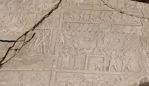
Figure 1: The horse at the entrance gate of the city, holding the entrance gate of the city, indicates the importance attributed to the horse. The Harput Relief is 2.72 metres high and 2.25 metres wide and is divided into five parts. It is in Elazığ Archaeological and Ethnographic Museum. The Harput Relief and the epic narrative with elements of imagery; the resistance and capture of the attackers who used a tower that could move with wheels to overcome the city walls and capture the city [31, 103].
The historical events depicted on the relief take place around the city walls that border the city. The depiction in Figure 2 shows a horse standing guard at the entrance gate of the city wall. In other words, the horse was assigned the most important role in the defence of the fortress. The palaeozoological significance of this horse is very great. In this context, the evolutionary history of the wild horse goes back to 50 million years ago. The wild horse, which lives in forested areas, is 20 cm tall and has many fingers. It eats mainly plant leaves. Its fingers are sharp. Over the next 40 million years, the size of the horse increases and the time begins when it feeds on meadow plants. With the increase of steppes and the decrease of forested areas about ten million years ago, the horse’s feet gradually acquired a hoof structure and resembled today’s horse. It spread mainly in the grasslands of North America and reached a size of 120 cm. The precursors of today’s horse can be traced to Eurasia only 1.5 million years ago [97, 98, 99, 100]. The horse has been man’s closest friend for thousands of years. It is an indispensable helper, making his life easier and assisting him at every stage. According to some DNA analyses, the horse was domesticated 5500 years ago in Central Asia, Asia Minor, Kazakhstan, the Caucasus steppes, Ukraine, Egypt and Romania (a thousand years earlier than the date assumed before these studies). About 12 000 years ago, i.e. during the last Ice Age, the colour of the horse was brown and black, but with the intervention of man, different horse colours emerged [31, 96, 97, 98, 99, 100].
The fact that no horse reliefs were carved on the T-shaped, 5m high and 12-15 Ton stone blocks at Göbekli Tepe, considered the sacred site of the oldest civilisation in Mesopotamia, shows that the horse was still unknown there [10, 11]. Until two thousand years BC, the fate of wars was determined by heavily equipped infantry; from two thousand years BC, however, the horse was harnessed in front of chariots in Asia Minor and Egypt and played a role in changing the fortunes of war. The first use of the horse was not in Mesopotamia, but in the remote mountainous regions and the steppes beyond. For this reason, the Sumerians called the horse “mountain donkey”. The horse, which became involved in the social life of Mesopotamia around 3500 BC, was a very rare and precious animal that was only ridden on the chariots of royal officials [101]. The horse breed at the gate (Figure 2), which resembles today’s horse and is one of the most important figures in the events depicted on the Harput relief because of its importance, could be a steppe horse breed best suited for cold conditions, war, carrying loads and other purposes. It is believed that this breed gained prominence when tribes from Central Asia, South Asia, Mesopotamia and the Northeast came to Harput and settled here. This steppe horse breed, which has an upright shoulder and a straight neck, can gallop without tiring and is very successful over long distances. Another characteristic of this breed is that it is good-natured and hardy and can easily adapt to difficult climatic conditions; it tolerates drought and is very frugal when it comes to food (tierfreunde). For this reason, the steppe horse that waits in front of the gate of the city wall in the relief of Harput is the most important element of the relief. The tame horse was first used by the Hurri (a tribe said to have originated in the North Caucasus) to pull two-wheeled carts. This horse breed is probably the “steppe horse breed”, as it resembles the one depicted on the relief. The same study states that the Hurrians are also called “warrior tribes with chariots” for this reason. The diverse excavations to be carried out in the region of the Harput relief will provide a far more satisfactory archaeological interpretation.
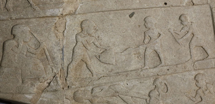
The relief in Harput is said to be 4000 years old [31, 102]. The Hittite and Assyrian representations of war and especially the depiction of the use of the wheel tower as a war material are extremely significant and important. The goddess with a serpentine body from the waist down and an eagle’s claw as a symbol of power stands over two naked enemy soldiers above the entrance gate of the city wall, lifting an enemy soldier whom she has defeated. The figure of the goddess with the serpentine body from the waist down is also found in the Old Babylonian period and is actually considered to be an underground goddess with Egyptian artistic features [103]. It is believed that the goddess, who is the main iconographic element of the relief, played an important role in winning the war. She is also associated with the powers of the underworld and is said to bring wealth and prosperity. The snake, which has been assigned this role, has been symbolised since prehistoric times [31, 102, 103, 104, 105]. The relief found by chance on Kurey Hill, named the Harput Relief, gives us important clues about Harput and its surroundings. The information and documents obtained from the systematic and palaeozoological studies to be carried out in this region will perhaps trace the history of Harput much further back. In the temples of the air god Tessup Arrapka (Kirkuk) and Haleb (Aleppo), chariots drawn by two bulls called Seris and Huris, representing the gods of day and night, also refer to the concept of time. Chepat, the sun god, and Kumarbi, the father of the gods, are also depicted. In the clay tablet inscriptions at Boğazköy, the capital of the Hittites, around 1600 BC, Kumarbi, the time god of the Hurrians, appears in the myths as Alalu, the god of the king of heaven. Alalu sits on his throne and Anu, the first of the gods, stands before him. Later Anu started a war against Alalu, defeated him, chased him deep into the black earth and sat on the throne. Anu was provided with water and food by the mighty Kumarbi; after nine years Anu served as god of the sky; then he went to war against Kumarbi, the chief god of the Hurrians and Hittites, but could not prevail against Kumarbi and flew into the sky as a bird. Probably one of these bulls points to the gods called Night (Huris) and the other to Day (Seris). We can say that the representation of these two bulls is important to express the Hurri or Hittite god Tessup/Tesup, who is responsible for weather events and the concept of time. The same god is also known to be depicted in the temples of Kirkuk and Aleppo. In the cuneiform and clay tablets of the Hittite capital Hattusa (Boğazköy), Kumarbi, the god of time from the myths of the Hurrians, expresses the god of heaven in early Anatolian times [98, 106, 107, 108, 109]. The bulls, considered by the Hurrians to be the gods of day and night, were used to pull the chariot. The free depiction of these two bulls on the Harput relief can be seen as a small contribution to the presence of the Hurrians here.
The upper part of the Harput relief shows snapshots of war and booty. The Hurrians, perhaps the first tribe in Kharpert, not only fight but also depict the settlement of the people, as can be seen in the lower part of the relief. It is clear that agriculture as well as water management and animal husbandry were practised here. The relief of Harput shows the traces of the settlement of Catalhöyük, which represents the first agricultural and hunting society of Anatolia and dates from the time when the sedentary order was introduced, possibly even covering a history of at least 8,000-9,000 years. Due to the extensive and systematic archaeological investigations being carried out on the Kurey mound of Harput, it will be possible to date Harput to a much earlier period [110, 111, 112, 113].
Conclusions
An attempt has been made to provide some historical information on the chronology of the civilisations that ruled Harput and the Elazığ region based on the source data. The
importance of Harput and its surroundings in the historical process has been highlighted. In addition, summary information on the settlement and archaeological history of Harput and its immediate surroundings from thousands of years ago to the present is presented in this study.
Especially before the formation of the Keban and Karakaya reservoirs, very rich information about the history of Harput and its surroundings was collected through rescue excavations in the neighbouring regions in the immediate vicinity of Harput. These excavations have brought to light much that is unknown about the history of the region. However, it is to be noted that much more important information and documents can be obtained if systematic and regular excavations are carried out in the region.
In this study, it was found that the history of Harput can be traced back to the Pottery-free Neolithic Period. Before the construction of Keban and Karakaya dams, important historical information was obtained through archaeological paleobiological rescue excavations [21, 25, 26, 27, 28, 29, 30, 31, 89]. The faunal and floristic biodiversity of Harput and its surrounding ecosystem was also determined through the analysis of bone and plant remains of the animals that lived in the Pottery-free Neolithic Period. Information about the historical and palaeobiological richness of Harput and its surroundings is given [5, 83]. These are respectively Rabbit (Lepus europaeus), Squirrel (Sciurus anomalus); Wolf (Canis lupus); Red fox (Vulpes vulpes); Weasel (Mustela nivalis); Bear (Ursus arctos); Striped hyena (Hyaena hyaena); Wild cat (Felis silvestris); Anatolian panther (Panthera pardus tulliana); Wild boar (Sus scrofa); Red deer (Cervus elaphus), the most common species; fallow deer (Dama dama); roe deer (Capreolus capreolus); wild goat (Capra aegagrus); wild sheep (Ovis gmelini anadolica); wild cattle (Bos primigenius); wild ox (Bos taurus); bison (Bison bonasus) [49, 73, 74]. Greylag goose (Anser anser), Mallard (Anas plathyrhynchos), Long-legged Buzzard (Buteo rufinus), Chukar Partridge (Alectoris chukar), Great Bustard (Otis tarda), Eurasien Eagle Owl (Bubo bubo); Rock Pigeon (Columba livia); Eurasien Collared Dove (Streptopelia decaocta); Carrion Crow (Corvus corone); Black-billed Magpie (Pica pica), Eurasien Jackdaw (Coleus monedula); House Sparrow (Passer domesticus); Starling (Sturnus vulgaris) and Tortoise (Testudo graeca) were found [22, 23, 25, 30, 63].
Some information on the representation of the relief of Harput is also given and suggestions are made.
Declaration of Competing Interests
The authors declare no competing interests.
References
-
Sunguroğlu İ (1958) Harput Roads C.1. Elazığ Culture and Promotion Foundation Publications No: 2. İstanbul, pp: 376ss.
-
Sunguroğlu İ (1959) Harput Roads C.2. Elazığ Culture and Promotion Foundation Publications No: 2. İstanbul, pp: 552ss.
-
Sunguroğlu İ (1961) Harput Roads C.3. Elazığ Culture and Promotion Foundation Publications No: 2. İstanbul, pp: 384ss.
-
Sunguroğlu İ (1968) Harput Roads C.4. Elazığ Culture and Promotion Foundation Publications No: 2. İstanbul, pp: 355ss.
-
Ozdoğan M (2018) The Changing Definition of Neolithic Nomenclature from Yesterday to Today. Azərbaycan Arxeologiya. Cild 21(1): 12-39.
-
Kiziroğlu İ (2022) History of Kharput and its Surraundings. Tarih Araştırmaları Dergisi 72(41): 31-53.
-
Kiziroğlu İ (2023) History of Harput and Surroundings. Elazig Culture and Promotion Foundation Journal 33(58): 7-17.
-
Schmidt K (1998) Early Neolithic temples: A research report on the preceramic Neolithic of Upper Mesopotamia. Mitteilungen der Deutschen Orientgesellschaft 130: 17- 39.
-
Schmidt K (2000) First came the temple, then the city. Report on the excavations at Gürcütepe and Göbekli Tepe 1996-1999. Istanbuler Mitteilungen 50: 5-40.
-
Schmidt K (2016) They built the first temples: The mysterious sanctuary at Göbekli Tepe (German), Hardcover CH Beck.
-
Kiziroğlu İ (2019) Ekolojik Potpouri II. Sarıyıldız Mat. Ankara, 425ss.
-
Luckert KW (2019) Göbekli Tepe. Çev Basmacı LT . ALFA Basımevi Yay. Istanbul, pp420 pp.
-
Dietrich O, Nortreff J, Schmidt K (2015) Göbekli Tepe. An exceptional archaeological site from the earliest Neolithic period on the way to becoming a World Heritage Site. In: Tagungsband des Internationalen Symposiums, Anatolien – Brücke der Kulturen“ in Bonn vom 7. bis 9. Juli 2014. Ed. Ünsal Yalçın & Hans-Dietert Beinert, Bochum, Bonn, Anatolien-Brücke der Kulturen, pp: 91-109.
-
Hayli S (1989) Functions and Field of Harput City in terms of Historical Geography. Harput with its Past and Present 24-27 September 1988, Elazığ.
-
Ünal MA (1989) Harput Sanjak in the XVIth Century. Turkish Historical Society Press Office. Ankara, pp: 276.
-
Aksın A (1999) 19th Century Kharpert. Ceren Ofset, Elazığ, pp: 319ss: s.29-35.
-
Sevin V (1991) The Early Iron Age in the Elazığ Region and the Problem of The Mushkians. Anatolian Studies 41: 87-97.
-
Akyel S (2015) An Evaluation on the Demographic Structure of Kharpert Sanjak in the XIXth Century. An Evaluation on the Demographic Structure of the Sanjak of Harput, in the 19th Century. 57: 199-220.
-
Gaspak A (2015) Historical and Religious Structure of Harput in Antiquity. İlahiyat Fakültesi Dergisi 20(1): 143-164.
-
Uzun C (2016) Harput in the 17th Century. Doctoral Thesis. Fırat Üniv, Sosyal Bil. Enst, Tarih ABD, pp: 398.
-
Boessneck J Driesch A (1975) Animal bone finds from Korucutepe near Elazığ in eastern Anatolia. Korucutepe. Vol. l, (Yayl. M.N.van Loon), North -Holland Publishing Company, Amsterdam, Oxford, New York, pp: 120
-
Boessneck J, Driesch A (1976a) Prehistoric Wild Animals of Altinova According to Bone Finds from Norşuntepe and Other Mounds. Keban Project 1972 Studies. ODTÜ Keban Projesi yayınlan, TTK Basımevi 1(5): 60-69.
-
Boessneck J, Driesch A (1976b) Tülintepe 1971-1972 Excavated Animal Bones. Keban Project 1972 Studies. ODTÜ Keban Projesi yayınlan 1(5): 145-146.
-
Boessneck J, Driesch A (1979) Tülintepe 1971-1972 Excavated Animal Bones. Keban Project 1972 Studies, Ankara, pp: 95-96.
-
Bökönyi S (1982) The Climatic lnterpretation of Macrofaunal Assemblages in Near East. Palaeoclimates, Palaeoenvironments and Human Communities in the Eastem Mediterranean Region in Later Prehistory. BAR Int Series, 133, part ii, Oxford, H9, pp: 163.
-
Hauptmann H (1976) Norşuntepe Excavations, 1972. Keban Project 1972 Works. Orta Doğu Teknik Üniversitesi Keban Projesi Yayınları, Seri I-No: 5, Ankara, pp: 41-60.
-
Esin U (1982) Tepecik Excavation, 1974. Plates 53-78.’, Keban Project 1974- 1975 Studies. ODTÜ Keban Projesi Yayınları Seri 1(7): 71-118.
-
Di Nocera GM (1998) Arslantepe VIII, The Middle Bronze Age settlement of Arslantepe, Roma.
-
Frangipane M (2000) The Late Chalcolithic/EB I Sequence at Arslantepe. Chronological and cultural remarks from a frontier site. Chronologies des pays du Caucase et de l’Euphrate aux IVe-IIIe millénaires. From the Euphrates to the Caucasus: Actes du Colloque d’Istanbul, pp: 439-471.
-
Atlı NB, Binder D (2007) Kömürcü - Kaletepe Obsidian Workshop, In: M Özdoğan, N Başgelen (Eds.), The East of Civilisation in Anatolia and its Spread to Europe - Neolithic Period in Turkey - New Excavations, New Finds. Arkeoloji ve Sanat Yayınları, İstanbul, pp: 217–222.
-
Demir B, Abay E, Sevin V (2016) Harput Relief: A New Contribution to Anatolian Civilisations. Arkeoloji ve Sanat 153: 7-16.
-
Alpman A (1981) ‘Hurries’. Ankara Üniversitesi Dil Tarih Coğrafya Fakültesi Tarih Araştırmaları Dergisi 14(25): 283-313.
-
Rollefson GO (2000) Synthese: The Late Aceramic Neolithic of the Levant: A Synthesis. Paleorient 1989: 168-173.
-
Harmankaya S (1997) An Evaluation on Neolithic Research in Turkey. In: S Harmankaya; O Tanındı; M Özbaşaran (Eds.), TAY – Türkiye Arkeolojik Yerleşmeleri-2: Neolitik, Ege Yayınları, İstanbul, pp: 13- 20.
-
Özdoğan M (2007) Some Generalisations – Insights. In: M Özdoğan, N Başgelen (Eds.), The Birth of Civilisation in Anatolia and its Spread to Europe – Neolithic Period in Turkey - New Excavations, New Findings, Arkeoloji ve Sanat Yayınları, İstanbul, pp: 441-455.
-
Çoksolmaz E (2011) Distribution of Pottery-Free Neolithic Period Settlements in Anatolia Selçuk University Institute of Social Sciences Department of Archaeology Division of Prehistory Archaeology Master’s Thesis. Konya, pp: 273.
-
Alparslan M (2014) Cultural Heritage and Tourism Open Education Programme, pp: 277.
-
Aslantür N (2014) A Study on the Hometown of Isuva. Ankara Üniversitesi Sosyal Bilimler Dergisi 5(1): 59-133.
-
Coşkun N (2018) Keban Project: A New Look at the Aggin Hoşrik Mevkii and Kalecikler Rescue Excavations. Anadolu Araştırmaları 21: 124-153.
-
Ağırsoy ZB (2019) Chipped Stone Industries in the Late Pottery Neolithic to Pottery Neolithic Transition in Southeastern Anatolia. Anadolu/Anatolia 45: 169-195.
-
Schmidt K (2013) Eagle and snake: ‘Great images’ of Göbekli Tepe and their reception”, Anatolian Metal VI (Hrsg.Ü. Yalçın), Bochum, pp: 145-152.
-
Özdoğan M (1977a) Lower Euphrates Basin 1977 Survey. Lower Euphrate Project Publications I, 2. Istanbul, Middle East. Technical University.
-
Özdoğan M (1977b) Lower Euphrates Basin 1977 Surveys. Middle East Technical University Lower Euphrates Project. İstanbul.
-
Özdoğan M (2019) From Raw Materials to Craftsmen: Prehistory, Arkeoloji ve Sanat Yayınları.
-
Goetze A (1955) Hittite Myths, Epics, and Legends, Ancient Near East Texts Relating to the Old Testament =ANET), ed. James Pritchard, PrincetonPrinceton University Press), 120f; Meriggi, Athenaeum 31(1953): 110.
-
Sevinç F (2008) The Economic and Social System Established by the Hittites in Anatolia. SDÜ Fen Edebiyat Fakültesi Sosyal Bilimler Dergisi, p. 17, Isparta, pp:11-32
-
Esin U (1976b) Tulintepe Excavation, 1972. Plates 76-
-
Keban Project 1972 Studies. ODTÜ Keban Projesi Yayınları 1(5): 119-133.
-
Esin U, Arsebük GMA (1974) Tulintepe Excavation, 1974. Plates 112-123. Keban Project 1971 Studies. ODTÜ Keban Projesi Yayınları 1(4): 137-141.
-
Esin U, Arsebük GMA (1982) Tulintepe Excavation, 1974. Plates 79-98. Keban Project 1974-1975 Studies. ODTÜ Keban Projesi Yayınları 1(7):119-125.
-
Ertem H (1979) Korucutepe Excavation, 1973. Keban Project 1973 Studies, Orta Doğu Teknik Üniversitesi Keban Projesi Yayınları, Ankara 1(6): 33-43.
-
Loon van, MN (1968-1970) Conclusions: in m.n. van loon (Edn.), Korucutepe. Final Report on the Excavations of the Universities of Chicago, California (Los Angeles) and Amsterdam in the Keban Reservoir, Eastern Anatolia 1968-1970. Vol. 3, Amsterdam, New york, Oxford, pp: 271-277.
-
Griffin EE (1980) The Middle and Late Bronze Age Pottery. In: MN Van Loon (Ed.), Korucutepe 3, Amsterdam, pp: 3-109.
-
Umurtak G (1996) Hittite Age pottery found during the excavations of Korucutepe II. 1973-1975 Period, Ankara.
-
Hauptmann H (1970) Norşun-Tepe Historical geography and results of the 1968/69 excavations. Istanbuler Mitteilungen 19(20): 21-78.
-
Hauptmann H (1974) Norşun Tepe Excavation, 1971. Keban Project 1971 Studies, Orta Doğu Teknik Üniversitesi Keban Projesi Yayınları, Ankara 1(4): 71-83.
-
Serdaroğlu Ü (1969) Ağın and Kalaycık Excavations. Turkish Journal of Archaeology 17(2): 185-210.
-
Serdaroğlu Ü (1970) Ağın and Kalaycık Excavations Preliminary Report. 1968 Summer Studies, Text, Middle East Technical University Keban Project Publications 1(1): 29-40.
-
Serdaroğlu Ü (1971) Ağın ve Kalaycık Kazıları, 1969. Keban Projesi 1969 Çalışmaları, Orta Doğu Teknik Üniversitesi Keban Projesi Yayınları 1(2): 23-26.
-
Serdaroğlu Ü (1972) Ağın and Kalaycık Excavations 1970. Keban Project 1970 Studies, Middle East Technical University Keban Project Publications 1(3): 7-23.
-
Esin U (1979a) Tepecik Excavation, 1973. Plates 46-
-
Keban Project 1973 Studies. ODTÜ Keban Projesi Yayınları 1(6): 79- 94.
-
Ertem H (1972) Khan Ibrahim Shah Excavation, 1970. Keban Project 1970 Studies. Orta Doğu Teknik Üniversitesi Keban Projesi Yayınları 1(3): 75- 79.
-
Ertem H (1982) Korucutepe Excavation, 1974, 1975. Plates 1-12 ’Keban Project 1974-1975 Studies. ODTÜ Keban Projesi Yayınları 1(7): 1-5.
-
Koşay HZ (1976) Keban Project Pulur Excavation 1968- 1970. Middle East Technical University Keban Project Publications 3(1): 35-37.
-
Sevin V (1986) Malatya-Elazig-Bingol Provinces Survey, 1985. Research Results Meeting 4(1): 279-300.
-
Sevin V (1988a) Imikusagi Excavations, 1986 Excavation Results Meeting 9(1): 299-333.
-
Sevin V (1988b) Eastern Anatolia Early Iron Age and the Mushkiler Problem. Höyük I, Türk Tarih Kurumu, pp: 51- 63.
-
Sevin V (1998) The Northern Distribution of the Khabur Ceramics in the Light of the Excavations at Imikushagi. Uluslararası Assiriyoloji Kongresi Bildiriler, Ankara 34: 383-393.
-
Konyar E (2006) Old Hittite Presence in the East of the Euphrates in the Light of the Stratigraphical Data from İmikuşağı (Elazığ). In: DP Mielke, UD Schoop, J Seeher (Eds.), Strukturierung und Datierung in der hethitischen Archäologie, Voraussetzungen-Probleme-Neue Ansätze, Internationaler Workshop Byzas 4, İstanbul, pp: 333- 349.
-
Kunç Ş, Gül Ş (1983) Trace Element Analyses of Old Mineral Deposits and Natural Copper in Turkey. TÜBİTAK ARÜTOB 3: 85-102.
-
Yiğit T (1995) İşuva Region in the Prehistoric and Hittite Period. Journal of Historical Research 17(28): 233-251.
-
Yiğit T (2005) First Records of the Hurris in Hittite Cuneiform Documents. Ankara Üniversitesi DTCF Tarih Araştırmaları Dergisi 24(38): 55-69.
-
Esin U (1976a) Tepecik Excavation, 1971. Plates 97-
-
Keban Project 1972 Studies. ODTÜ Keban Projesi Yayınları 1(5): 109-121.
-
Esin U (1979b) Tulintepe Excavation, 1973. Plates 66-
-
Keban Project 1973 Works. ODTÜ Keban Projesi Yayınları 1(6): 115-119.
-
Esin U (2000) Tulintepe Rescue Excavations. Archaeology of Turkey and Istanbul Universityi, pp: 87-90.
-
Arsebük GMA (1974) The Problem of the Relationship between the Dark Faced Burnished and Karaz Type Pottery at Altınova, Istanbul University (Unpublished PhD Thesis), İstanbul.
-
Arsebük GMA (1979) The Relationship between Dark Faced Burnished and Karaz Type Pottery at Altinova (Elazig). Türk Tarih Kongresi 8: 81-92.
-
Arsebük GMA (1986) The Problem of Culture and Social Stratigraphy from the Beginning to the End of the Early Bronze Age in Altinova (Elazig). IX. Türk Tarih Kongresi Bildirileri 1: 67-72.
-
Ökse AT (1988) Middle Iron Age pottery of Central East Anatolia with a focus on the Karakaya dam area on the Euphrates River, Berlin.
-
Yalçın Ü, Yalçın HG (2003) On the Karaz pottery of Tepecik Eastern Anatolia’ Archaelogical Essays Honour of Homo Amatus: Zur Karaz Keramik von Tepecik Ostanatolien. Archaelogical Essays Honour of Homo Amatus: Güven Arsebük, İstanbul, pp: 321-342.
-
Işıklı M (2007) The Beginning of Karaz Culture in Erzurum Region: A General Evaluation of Recent Researches. In: B. Can, M. Işıklı (Eds.), Doğudan Yükselen Işık Arkeoloji Yazıları, İstanbul, pp: 325-350.
-
Yalçın HG (2012) The Karaz pottery of Tepecik Eastern Anatolia. Die Karaz Keramik von Tepecik Ostanatolien, İstanbul.
-
Akçelik SS (2018) Karaz Culture in Aşkale and Surroundings in the Light of Surface Researches. Kafdağı 3(2): 94-129.
-
Geraads D, Güleç E, Kaya T (2002) xZ Sinotragus (Bovidae, Mammalia) from Turkey, and the Late Miocene Middle Asiatic Province. Neues Jahrbuch für Geologie und Paläontologie Monatshefte 8: 477-489.
-
Schmidt K (2007) The stone circles and reliefs of Göbekli Tepe. The most ancient monuments of mankind. Die Steinkreise und die Reliefs des Göbekli Tepe, Die aeltesten Monumente der Menschheit. Badisches Landesmuseum Karlsruhe vor 12000 Jahren in Anatolien, pp: 83-91.
-
Esin U (1970) Tepecik Excavation 1968 Preliminary Report. 1968 Summer Work. ODTÜ Keban Projesi Yayınları 1(1): 147-172.
-
Arslantaş Y (2014) General Situation of Harput and its Surroundings in the Chalcolithic Age. Fırat Üniversitesi Harput Araştırmaları Dergisi 1(2): 87-110.
-
Zeist W, Bakker-Heeres JAH (1975) Prehistoric and Early Historic Plant Husbandry in the Altınova Plain, Southeastern Turkey, Korucutepe. Vol. I, (Yayl. M.N.van Loon), North-Holland Publishing. Company, Amsterdam, Oxford, New York, pp: 222-257.
-
Kiziroğlu İ (2015) Pocketbook for Birds of Türkiye. Türkiye Kuşları Cep Kitabı. (Türkçe & İngilizce; renki resimli). Sarıyıldız Ofset ve Matbaacılık, Ankara, pp: 577.
-
Özbaşaran M (1992) The Place of Tulintepe Settlement in the Chalcolithic Architecture of Eastern and Southeastern Anatolia. PhD Thesis, Mart; TC İstanbul Üniversitesi Sosyal Bil. Enst. Prehistorya Bilim Dalı, Metin, pp: 173.
-
Hauptmann H, Schmidt (2000) Early temples - early gods? In: German Archaeological Institute, Archaeological Discoveries. The research of the German Archaeological Institute in the 20th century. Frühe Tempel - frühe Götter? In: Deutsches Archäologisches Institut, Archäologische Entdeckungen. Die Forschungen des Deutschen Archäologischen Instituts im 20. Jahrhundert. Zaberns Bildbände zur Archäologie, pp: 258-266.
-
Zick M (2008) Turkey - the cradle of civilisation. Türkei – Wiege der Zivilisation. Konrad Theiss Verlag, Stuttgart, pp: 167.
-
Hauptmann H (1982) Norşuntepe Excavations, 1974. Keban Project 1974-1975 Studies. Orta Doğu Teknik Üniversitesi Keban Projesi Yayınları 1(7): 15-71.
-
Orthmann W (1985) The Ancient Orient. Der Alte Orient. Propylaen Kunstgeschichte Band 18, Berlin. Yayınevi.
-
Foster BR (1985) The Sargonic Victory Stele from Telloh. Iraq 47: 15-30.
-
Nigro L (2003) La Stele di Rimush da Tello: E L’Indicazione del Rangodei Vintinel Rilievo.
-
Nadali D (2009) Representations of Battering Rams and Siege Towers in Early Bronze Age Glyptic Art. Historiae 6: 39-52.
-
Kiziroğlu İ (2010) Science of Living Things. General Biology. Baskı. Ankara. Okutman Yayıncılık, pp: 607.
-
Ludwig A, Pruvost M, Reissmann M, Benecke N, Brockmann GA, et al. (2009) Hittites and Anatolia in the Hittite Age. (Çev) Esra Davutoğlu, İstanbul.
-
Outram AK, Stear NA, Bendrey R, Olsen S, Kasparov A, et al. (2009) The Earliest Horse Harnessing and Milking. Science 323(5919): 1332-1335.
-
Abay E, Demir B, Sevin V (2021) The Relief of Harput. A New Page in the Art History of Ancient Anatolie. De Gruyter.
-
Usta S (2018) The Role of the Horse in the Development of Civilisation. Science and Future.
-
Loral A (2025) 4,000-Year-Old Harput Relief Discovered by Chance Sheds Light on History. Anatolien Archaeology.
-
Dönmez S (2017) An Evaluation on the Cult of the Serpent Goddess in the Ancient Near East. Tarih İncelemeleri Dergisi 32(2): 407-426.
-
Dönmez S (2019a) 2017 Malatya Archaeological Survey. 36th Research Results Meeting. 3. Cilt. T.C.Kültür ve Turizm Bakanlığı, Kültür Varlıkları ve Müzeler Gn.Md., 07-11 Mayıs 2018, Çanakkale, pp: 371-390.
-
Dönmez S (2019b) 2017 Malatya Archaeological Survey. 37th Research Results Meeting. 3. Cilt. T.C.Kültür ve Turizm Bakanlığı, Kültür Varlıkları ve Müzeler Gn.Md., 17-21 Haziran 2019, Diyarbakır, pp: 349-366.
-
Güterbock HG (1946) Kumarbi. Myths of the churritic Kronos. Kumarbi. Mythen vom churritischen Kronos, Zürich/ New York (Europaverlag), pp: 6-28.
-
Otten H (1950) Myths of the god Kumarbi. New fragments, Mythen vom Gotte Kumarbi. Neue Fragmente, Berlin (Akademie-Verlag), pp: 6.
-
Otten H (1961) The Hittite Empire. In: Hartmut Schmöckel (ed.), Cultural History of the Ancient Near East. Das Hethiterreich. In: Hartmut Schmöckel (Hrsg.),Kulturgeschichte des Alten Orients Stuttgart. Kröner, pp: 311-346.
-
Lüdge M (2008) Heaven as the home of the soul. Visionary ascension practices and constructs of divine worlds among shamans, magicians, Anabaptists and Sethians. Iranian traces in the Zostrianos of Nag Hammadi. Der Himmel als Heimat der Seele. Visionäre Himmelfahrtspraktiken und Konstrukte göttlicher Welten bei Schamanen, Magiern, Täufern und Sethianern. Iranische Spuren im Zostrianos von Nag Hammadi. Habilitation an der Georg August Universität Göttingen im Fachbereich Evangelische Theologie 1092: 51
-
Yalçın Ü, Yalçın HG (2009) The hoard find from Tülintepe, Eastern Anatolia, The incision. Anatolia. Der Hortfund von Tülintepe, Ostanatolien, Der Anschnitt. Anatolien Metal IV. Beiheft 21: 101-123.
-
Nadali D, Verderama L (2008) The Akkadian ‘Bello Stile’. RD Biggs vd (yay) Proceedings of the 51st Rencontre. Assyriologique Internationale, pp: 309-320. Chicago. Realle Accadico”, Scienze dell’Antichita Storia Archeologia Antropologia 11: 7
-
Ludwig A, Pruvost M, Reissmann M, Benecke N, Brockmann GA, et al. (2009) Coat Color Variation at the Beginning of Horse Domestication. Science 324(5926): 485-485.
-
(2024) The history of horses. tierfreund.de.
- The Indispensable Role of Informal Caregivers in Supporting the Aging Population
- Socio-Religious Significance of Kamakhya Temple in Guwahati, Assam
- Is Anthropology Possible?
- A Study on the Cowrie Shells of the Dimasas in Assam
- The Significance of International Organizations Cooperation in the Efficient Resolution of Global Conflict
- Sketch about the Hagiographic Universe in the Cult of San La Muerte in the Northeast of the Argentine Republic