An Engineered and Sustainable Solution for Flood and Sediment Management in Kosi River, India
Introduction
Bihar is one of the most severely affected state due to the floods in India and it has nearly 6.88 million hectares of flood prone area which is about 73.06% of its total geographical area. The Ganges River, popularly known as the Ganga River is the main river of Bihar which flows across the state from the west to the east by traversing a distance of 445 km and divides the state into two unequal halves namely North Bihar plains and South Bihar plains [1, 2, 3]. Figure 1 shows the major river basins of the plains of North Bihar and South Bihar.
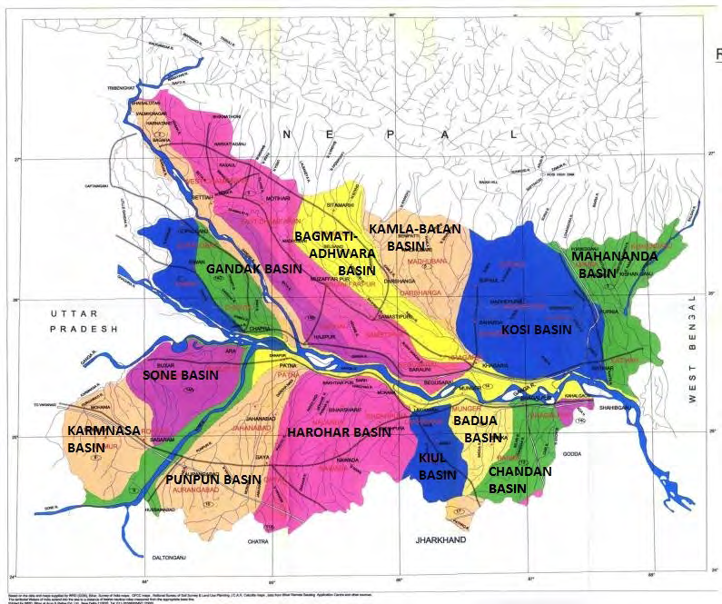
(Source – NDMA, 2013) [1] Figure 1: Map showing major river basins in Bihar.
North Bihar is more prone to floods than South Bihar. The major rivers of North Bihar are the Gandak, the Burhi Gandak, the Bagmati-Adhwara, the Kamla-Balan, the Kosi and the Mahananda. Except the river Burhi Gandak, most of the rivers of the North Bihar are originated in the Himalayas in Tibet or Nepal and the significant portion of the catchment area of these rivers lie in the glacial region of Himalayas [4]. These rivers are responsible for the devastating floods in the plains of North Bihar and cause enormous loss of lives, property, agriculture and infrastructure. The recurrent flooding has been damaging the socio-economic life of the region for a very long time.
Among all of the rivers of the North Bihar, the Kosi river is the most unstable river in Bihar. It is one of the largest tributary of the river Ganga originating from Himalayas in Tibet and joins the Ganga in Bihar after flowing through Tibet and Nepal. Majority of the drainage area of this river lies in Tibet and Nepal which is almost 85%, and only 15% lies in Indian Territory. The Kosi river has been known for its course changing tendency. The river has shifted its course in a westerly direction and it has laterally moved nearly 150 kilometers during last two centuries [5, 6]. However, during Kusaha breach in 2008, the river moved eastward of the course and the total movement was of the order of ~120 km [7]. The lateral movement of this magnitude was much higher than any single movement recorded in historical times. The lateral movement of the Kosi river has never been gradual one, as it has been taking sudden shifts from one course to another. Such sudden and large spatial shifts of river channels are termed as ‘avulsion’ Smith [8] which commonly originates from a nodal point. The avulsion is significantly different from slower lateral movements through meander migration or lateral tilting. Due to frequent migration, the Kosi river has caused a lot of destruction and widespread human suffering by extensive flooding in the past. It has caused heavy loss of agricultural land in the plains of North Bihar. For this reason, it is also known as the “Sorrow of Bihar”. The ‘Kosi project’ was formulated in 1954 aiming flood control, irrigation and hydropower generation in the Kosi basin under a bilateral agreement between Nepal and India. Under this project, the Kosi Barrage was built at Bhimnagar, Sunsari District in Nepal near Indo-Nepal border. To confine the westward movement of the river, the embankments on both sides downstream of the barrage for a length of about 387 km have been constructed under the ‘Kosi project’. The embankments on both sides of the river are kept at about 12 to 16 km [9]. Although the embankments have checked the lateral movements of the river, the flooding in the Kosi river still occurs almost every year at a different scale and has continued its havoc in the North Bihar.
Silent Features of Kosi River
The river Kosi originates at an altitude of over 7000 m above MSL in Tibet in the Himalayas and flows through Tibet, Nepal and India. It has very large portion of catchment area, nearly 85% in Tibet and Nepal. The upper catchment of the river system consists the Mount Everest and the Kanchenjunga. In Nepal, the river Kosi is known as Saptakoshi for its seven upper tributaries. Out of its seven tributaries within the Himalayas, the Sun Kosi, the Arun and the Tamor are the three major ones. These tributaries join together at Tribeni about 10 km above Chatra in Nepal. Thereafter the much enlarged Saptakoshi flows through the Barahkshetra gorge for about 15 km and then debouches into the plain at Chatra [10]. Downstream of Chatra, the river flows some 50 km in Nepal and then it enters the Indian Territory through North Bihar near Hanuman Nagar in Nepal and joins the Ganga river near Kursela in Katihar district in Bihar. The basin in India Territory extends over areas of districts Saharsa, Purnea, Khagaria, Madhubani, Sitamarhi, Muzaffarpur and Darbhanga in Bihar state. The catchment area of the Kosi river including the catchment areas of its tributaries in plains is about 95156 sq. km, otherwise it is about 74030 sq.km [9]. The salient features of the Kosi river basin are presented in Table1.
| 74030 | |
|---|---|
| Drainage Area in India (sq. km) | 11410 |
| Surface water resources, (million cubic metre) | 52219 |
| Average annual rainfall (mm) | 1456 |
| Total length of main river (km) | 260 |
| Cropped area in Bihar(sq. km) | 8694 |
| Origin point | the Himalayas in Tibet |
| Tributaries in the plains | Bagmati, Kamla-Balan, Bhutahi-Balan, Trijuga, Fariani dhar and Dhemama dhar. |
Table 1: Salient Features of the Kosi river.
The entire catchment area of the Kosi river can be categorised into three zones: (a) Upper catchment zone (b) Mid area zone (c) Lower reach zone. The upper catchment zone lies completely in the mountainous region whereas the mid area zone comprises the area between the mountainous and plain portion of the catchment at the foothills of the Himalayas. The lower area zone lies completely in the plains and comprises large inland delta formed by the huge sandy deposit of the Kosi River [9]. On the plains of lower catchment area, the Kosi megafan has formed having general slope from north to south and west to east. A ‘megafan’ has been defined as “a large (103 –105 km2), fan-shaped (plan view) mass of clastic sediment deposited by a laterally mobile river system that emanates from the outer point of a large mountainous drainage network” [11]. The entire Kosi megafan is split into numerous “dhars” (small channels) representing paleo channels of the river. There are also innumerable depressions called “Chaurs” in the lower catchment of the river which remain waterlogged almost for the whole year. The lateral shifts of Kosi river have been avulsing in nature. Figure 2 depicts the overlay of different positions of Kosi River, Kosi megafan boundary and its lobe boundary as depicted in historical maps on LANDSAT image [12].
![Figure 2: Overlay of different positions of Kosi River as depicted in historical maps on LANDSAT image (Source: Chakraborty, 2010) [12].](/fulltextimages/7852/fig_2.png)
Historical Breaches in Kosi River Embankments
After the construction of embankments under the ‘Kosi project’, there have been many flooding events in the Kosi river basin due to the breaches of embankments. Any breach in upstream embankments causes huge destruction in the downstream basin. That is exactly what happened in the Kusaha breach in 2008. The upstream breach devastated the downstream regions protected by the embankment. Some of the past historical breaches in embankments of the Kosi river have been enlisted in Table 2 [10, 13].
| Year | Breached Places |
| 1963 | West embankment, Dalwa, Nepal |
| 1968 | West embankment, Jamalpur Darbhanga, Bihar (breached at five places) |
| 1971 | Near east embankment Matniyabandha, Bihar |
| 1980 | Near east embankment Baharawa Bihar |
| 1984 | East embankment, Hempur, Navahatta Block, Bihar |
| 1987 | Gandaul and Samani, Bihar |
| 1991 | West embankment, Joginiyan, Nepal |
| 2008 | East embankment, West Kusaha, Nepal |
Table 2: Summary of historical breaches in embankments of the Kosi river.
Problems Associated with the Kosi River
Excessive Rainfall
The Kosi river basin receives abundant amount of rainfall during southwest monsoon from June to September. The orographic effect and cloudbursts cause large temporospatial rainfall variation in the catchment area. About 500 mm of rainfalls in a single day are common in a large area of the catchment. The upper catchment is mainly responsible for the hydrological behaviour of the river. The impact of flooding in the Kosi river basin due to its smaller tributaries becomes widespread if magnitude and duration of the accompanying rainfall is higher. The glacial lake outburst in the upper Himalayas also contributes the flood water of great magnitude in downstream river reaches. The climate change affects these phenomenon and the extreme events have been intensified in the past decades [14].
Slope
The three major tributaries of the Kosi river above Chatra gorge flow along very steep slope (Fig. 3) and it greatly affects the flow in the Kosi river below Chatra [15]. The extensive plain of Kosi megafan is steeper in the north (55-75 cm/ km) and flatter in the south (6 cm/km) [16]. The average bed slopes of Kosi river from Chatra to Barrage, Barrage to Dagmara, Dagmara to Mahesi and Mahesi to Kursela are 1.4 m/km, 0.716 m/km, 0.45 m/km and 0.11 m/km respectively [9]. The lower reach zone of the river comprises large “inland deltas” formed by heavy siltation.
![Figure 3: Slopes of Sunkosi, Arun and Tamor rivers (Source: Zollinger 1979) [15].](/fulltextimages/7852/fig_3.png)
![Figure 4: The Kosi River megafan and its upland to plains area ratio (u/p). (Source: Sinha and Friend [17]; Sinha [7]](/fulltextimages/7852/fig_4.png)
Sediments
The Kosi river carries huge amount of sediment with its flow from hilly areas and deposits the sediments on the “inland deltas” in plains. It causes the lateral movement of the river. The excessive rainfall, cloudbursts, glacial lake outbursts and the steeper bed slope of the river lead to extensive soil erosion and landslides in the upper catchment and triggers the sediment flow in the river. The tributaries of Kosi in the plains also contribute in floodwater as well as sediments of the river. The Kosi river transports about 120 million cubic meter (MCM) sediment load every year which is one of the highest in the world, and 95% of the sediment flows during the month of monsoon [10]. Kumar [9] reports that the average annual sediment load of the river is about 95 million cubic meter at Barahkshetra. The Kosi river accommodates its exceptionally high sediment yield of 0.43 million tonnes/year/km2 in a very narrow alluvial plains (Fig. 4) which is almost one-fifth of the upland area [17, 7]. This has resulted in predominantly aggrading channels of the Kosi and building up of a very large positive topography called ‘megafan’. Gole and Chitale [5] related the lateral shifting of the Kosi river with the cone (megafan) building activity. They also explained that other Himalayan rivers are not so dynamic because they have built longitudinal valleys whereas Kosi is building up a conical delta. The lateral shifting of the river was explained as a result of conical delta building, sediment deposition and rise of bed levels.
Embankment Breaches
For a very long time, the structural measures like embankment and dam constructions have been considered as a primary solution for the flood control. The high dams were seen as the preferred method for the flood control of the river while embankments were seen just as a temporary measure. The reliance on structural solutions like embankments has promoted a false sense of security, particularly in the case of Kosi river. Table 2 summarizes the flood events due to the historical breaches in embankments of the Kosi river. Correlating the problem of breaches and sediments, suggested that unless the sedimentation between the Kosi embankments was reduced, breaches in the embankments was inevitable. Most analysts agree that the confinement of the Kosi within the embankment has further worsened the situation rather than solving the problem and it has caused significant aggradation within the channel belt [18]. The poor management of embankments and conventional technological choices for siltation control are making the embankments more prone to breach. In 2008 the Kusaha breach occurred for the discharge 1,44,000 cusecs much below the designed capacity of embankments 9,50,000 cusecs. On an average, the colossal damage to properties was of the order of about Rs. 150 billions in that event [19].
Trans-Boundary Dimension of the River and Nepal-India Treaty for the Kosi project also contributed to the disaster. The revised Kosi Treaty entrusts the responsibility of maintaining the project and its appurtenance with India. The treaty is vague about the need to maintain the barrage and embankments regularly. It does not accord any responsibility to the upstream stakeholder Nepal in the operation and management [10].
Need of Innovative and Sustainable Approaches for Flood and Sediment Management
The Kosi river has seen many breaches in the past which caused huge devastation in both India and Nepal. In the Kosi flood 2008 due to Kusaha breach, the population of about 3.3 million in India (Bihar) and 0.1 million in Nepal got affected, about 500 persons lost their lives and the colossal damage to properties was of the order of about INR 150 billion [19]. The present study has highlighted the major causes of flooding in Bihar like heavy rainfall, breaching of embankments, siltation of riverbeds, climate change etc. As it has been discussed in the previous section that the Kosi river flowing in the plains of North Bihar is a transboundary river with majority of its catchment area lying in the hilly regions in Tibet and Nepal. The sedimentation in the Kosi river has been its inherent problem. It is evident from figure 2 that the avulsion in the river was occurring even in the 18th century, when the minimal human activities in the vicinity of the river floodplain can be assumed. Human settlements, deforestations and conventional farming methods in the flood plains of the river both in Nepal and Bihar also affect the flooding and sediment problem. Though a lot of efforts have been made for flood management in Bihar including the Kosi project under bilateral Indo-Nepal agreement, the disasters due to floods keep on happening and still making the state suffer. The recurrent floods create a serious setback to the development of the region and make the life of the people very miserable in the affected region.
The flood management measures in the state have been primarily focused on ‘Grey Infrastructures’ (like dams, barrages, embankments, dykes etc.) which seems to be insufficient because the downstream catchment of the river in Bihar gets flooded almost every single year. Although these engineered structures have saved many lives and served many purposes, this approach has also resulted in many unintended negative consequences including the decline of freshwater ecosystems and the loss of productive floodplain and lead to the alteration of natural characteristics of rivers and floodplains.
The paradigm of flood management is changing with continued sustainable and innovative approaches in different parts of the world. The countries like the United States, the Netherlands and other European countries have successfully managed their severe flooding problems by the integration of innovative approaches like “Green Infrastructure” (GI) with conventional approaches. Green Infrastructure is a strategically planned network of high quality natural and semi-natural areas with other environmental features, which is designed and managed to deliver a wide range of ecosystem services and protect biodiversity in both rural and urban settings [20]. “Green infrastructure” encompasses natural features, such as forests and wetlands that provide similar or complementary flood-management benefits as engineered infrastructure [21]. Integration of grey infrastructure with green measures and especially floodplain restoration have been practiced in the case of the Mississippi river (US), the Sacramento river (US), the Rhine river (the Netherlands), the Elbe river (Germany) and many other rivers of western countries. Table 4 represents Green Infrastructure measures for flood risk reduction based on European Union’s Natural Water Retention Measures (NWRM) [22] catalogue [23]. These countries have successfully managed the flooding problems. It’s high time to adopt a sustainable and integrated approach for flood management which must address social, economic, institutional and ecological aspects to yield overarching benefits.
| NWRM code | Name of GI measure (based on the NWRM catalogue) | Flood risk reduction | Take adequate and coordinated measures to reduce flood |
| N01 | Basins and ponds | High | High |
| N02 | Wetland restoration and management | Medium | Medium |
| N03 | Floodplain restoration and management | High | High |
| N04 | Re-meandering | High | High |
| N05 | Streambed re-naturalisation | Medium | Medium |
| N06 | Restoration and reconnection of seasonal streams | Medium | High |
| N07 | Reconnection of oxbow lakes and similar features | Medium | High |
| N08 | Riverbed material re-naturalisation | Medium | High |
| N09 | Removal of dams and other longitudinal barriers | Low | Low |
| N10 | Natural bank stabilisation | Medium | Medium |
| N11 | Elimination of riverbank protection | High | Medium |
| N12 | Lake restoration | Medium | Medium |
| N13 | Restoration of natural infiltration to groundwater | Low | Low |
| N14 | Re-naturalisation of polder areas | Medium | High |
Table 3: Green Infrastructure (GI) measures for flood risk reduction.
A Green and Engineered Infrastructure Solution for the Flood and Sediment Management in the Kosi River
In the present study, it has been found that the Kosi river flooding is primarily associated with the problem of sediment. Any solution which will not address the sediment management of the river, will ultimately lead to the unexpected and catastrophic shifts in the river. It means that hard engineering solutions, such as the barrage and embankment scheme, are doomed to fail in the case of such a dynamic river system. It is the need of the hour to work with the river to allow some degree of dynamic behaviour, but in a controlled way. A combination of green infrastructure and grey infrastructure, engineered to specific challenges and objectives will be a sustainable and resilient approach to flood and sediment management in the Kosi river basin.
A solution was conceptualised in the form of high storage dam in 1950s with reservoir of 8.5 billion m3 gross storage and 4.08 billion m3 of dead storage for design life of 35 to 40 years, considering annual sediment inflow of 120 million cm [10]. Instead of high storage dam, a barrage (also referred as ‘Bhimnagar barrage’ or ‘Kosi barrage’) at Hanuman Nagar in Nepal and embankments along river banks were built. Even after the adoption of several measures, mostly grey infrastructure for the flood management in the Kosi river, the flood devastation in the region is still continued. The basic problem of sediment load was not addressed. The grey infrastructure approach gives a false sense of security and it also results in many unintended negative consequences.
Taking a cue from innovative practices used in flood management in the countries like the United States, the Netherlands and other European countries; a “detention cum siltation pond” may be an appropriate strategy for sediment and flood management. The detention cum siltation ponds at different places in the Kosi drainage area (about 74030 km2) are proposed to solve its flooding as well as sediment problem. These ponds will be designed to detain the floodwaters and sediments inflow during floods. The gross storage of the ponds are proposed on the basis of previously estimated gross storage of reservoir 8.5 billion m3 [10]. To find out the gross area required for the detention cum sedimentation ponds, the maximum depth corresponding to highest flood level (HFL) of the river is to be estimated. The riverbed level at Bhimnagar barrage was found to be 1126.5 m and HFL at the barrage as 1131.75 m, the maximum pond level (MPL) as 1135 m and top of wing walls as 1135.6 m [24]. This gives a general depth of flow 5.25 m corresponding to HFL, 8.5m corresponding to MPL and 9.1 m with the free board. This gives an idea about approximate depth of the proposed ponds which may vary from 5.5 m to 9.5 m. It has been estimated that the gross area for detention cum siltation ponds may vary from 894.74 km2 to 1545.45 km2 corresponding to 7.84 to 13.54 percent of drainage area of Kosi in India. Table 5 presents the estimated gross area and % of drainage basin of the Kosi river required by the proposed ponds for the maximum depths of 5.5 m 7.5 m and 9.5m. The estimated gross area will be divided into 10-20 ponds of different areas. To get an idea about the economic feasibility, considering ten equal square ponds corresponding to the maximum estimated gross area 1545.45 km2, the size of the pond will be about 12.5 km. The total cost of the all ponds will be approximately INR 5000 million (cost of embankment @ INR 10 million per km; NIDM [25]. For execution of the associated components of the ponds, it is enhanced to INR 10,000 million which is hardly
6.67% of the total damage caused by a single flood of 2008. These detention cum siltation ponds will be constructed at different places between the Kosi barrage in Nepal to Kursela in Bihar where the river confluences with the Ganga river. Most of the sediment flow (95%) in the river occurs during the south-west monsoon [10]. Floods due breaches, high discharge and lateral shifts also occur during the monsoon. These ponds detention cum siltation ponds will be designed to accommodate the floodwaters and sediments inflow during floods. The cleaning of the ponds will be done during non-monsoon season. Along with the construction of the ponds, some green infrastructure measures with grey infrastructures are also suggested as sustainable and integrated approach in the present study. These measures include: (a) creation of green rives, or ‘flood bypasses’ (b) connecting isolated water bodies (c) Stream bed re- naturalisation (d) restoration of vegetation (e) removal or setting-back of embankments wherever necessary (f) change in land use and land cover (LULC) pattern promoting retention of water. The selection of green infrastructures measures has been done on the basis of hydro-morphological characteristics of the basin.
The proposed detention cum siltation ponds with other GI measures for the flood and sediment management in the river basin have overarching benefits like fisheries, biodiversity preservation, water storage, groundwater recharge, erosion control, filtration of pollutants, recreational opportunities around the ponds etc. The environmental sustainability aspect adds a great value to feasibility of the proposed measures.
| Maximum Depth of Proposed Ponds (m) | Estimated Gross Area of the ponds (km2) | % of Indian drainage basin of the Kosi river required by the ponds | % of total drainage basin of the Kosi river required by the ponds |
| 5.5 m | 1545.45 km2 | 13.54 | 2.09 |
| 7.5 m | 1133.33 km2 | 9.93 | 1.53 |
| 9.5 m | 894.74 km2 | 7.84 | 1.21 |
Table 4: Estimated gross area and required % of drainage basin for the maximum depths.
Discussion
As it has been seen globally those floods cannot be absolutely controlled but with the help of proper flood management, their negative impacts can be minimized to a greater extent [26]. The present study has highlighted the major causes of flooding in Bihar like heavy rainfall, breaching of embankments, siltation of riverbeds, climate change, increased human intervention in floodplains etc. The poor maintenance of the embankments, the conventional flood management approaches and trans-boundary dimension of the north Bihar rivers are making the flood problem more severe in the state. Floods hit the state almost every year and cause huge damages to lives, property, agriculture and infrastructure; making the life of the people very miserable in the affected region. Apart from the total damages in billions during floods, the government spends billions in rescue and relief operation every year in the state. The recurrent floods in the Kosi and other rivers of north Bihar have become serious setback to the development of the region [27, 28].
In case of the Kosi river or any other rivers in Bihar, the flood management approach only by construction of embankments is too simplistic and this ignores the fundamentally related problems such as interfering the natural flow of river and heavy silt load transported by river. This leads to significant aggradation within the channel and increases the bed level of rivers which makes the embankments progressively more prone to overtopping and breaches. Water Resource Department (WRD) (http:// wrd.bih.nic.in/) itself agrees with the fact that the existing embankments are under increasing pressure due to rise in the bed level of rivers due to heavy silt loads brought by the Himalayan Rivers to the plains of North Bihar. Since these rivers have abnormal tendency to change their courses, it is very important to understand the dynamics of these rivers and the characteristics of floodplains. The adopted flood management measures in Kosi river basin are mostly engineered-grey infrastructure measures and do not effectively address the sediment management of the river. This results in frequent failure of the system and flooding in the basin area [29, 30, 31]. The engineered-grey infrastructure approach has also resulted in many unintended negative consequences including the decline of freshwater ecosystems and the loss of productive floodplain and lead to the alteration of natural characteristics of rivers and floodplains.
Therefore, there are two options left for flood risk management (FRM) in the Kosi river basin; either to rely on the current approach for FRM or spend billions almost every single year on the recurrent floods or to find a sustainable and innovative solution for the river basin. In order to find the solution of flood and sediment problems in the Kosi river, it is necessary to work with the river to allow some degree of dynamic behaviour, but in a controlled way. A sustainable and integrated approach for flood and sediment management in the Kosi river is proposed in the present study; taking the cue from the countries like the United States, the Netherlands and other European countries which have successfully managed their severe flooding problems by the integration of innovative approaches like “Green Infrastructure” with conventional approaches [32]. The detention cum siltation ponds is proposed at different locations between Bhimnagar barrage in Nepal and Kursela in Bihar to accommodate the floodwaters and sediments inflow during floods. The estimated gross area and % of drainage basin of the Kosi river required by these ponds for the maximum depth of pond of 5.5 m 7.5 m and 9.5 m are presented in Table 5. There are other GI measures also suggested along with this detention cum siltation ponds for the flood and sediment management in the river basin. The environmental sustainability aspect and inclusionary benefits like fisheries, biodiversity preservation, water storage, erosion control, filtration of pollutants, recreational opportunities around the ponds, groundwater recharge etc. add a great value to feasibility of the proposed measures. The use of the regions for purposes like fisheries, recreational activities, innovative farming etc. will also generate decent revenue for the state.
Conclusion
Flooding is the most common and recurrent natural disaster in Bihar. Flood occurs and causes great damages to the state almost every year during monsoon. With nearly three-fourth (73.06 %) area of the state as flood prone area, Bihar has suffered a lot. The flood problem is more severe in the North Bihar due to presence of Himalayan originated rivers. The Kosi, Bagmati, Adhwara, Kamla Balan are very unstable rivers of the North Bihar due to their course changing tendency. Among all of these rivers, the Kosi River, the “Sorrow of Bihar” is the most unstable and dynamic in nature. Majority of the drainage area of this river lies in Tibet and Nepal which is almost 85%, and only 15% lie in Indian Territory.
The present study is carried out to analyse the flood scenario in the Kosi River basin and the flood management measures adopted. The study highlighted the hydrological, geomorphological, trans-boundary and socio-economic factors for the flood disasters in the Kosi river basin. It is concluded that the problem of flooding in the river is implicitly governed by the huge amount of sediment inflow (about 120 million m3/Year) which is a major cause of the avulsing change in the morphological behaviour of the river. The historical breaches in the Kosi river embankments are also enlisted in the study. The ‘Kosi project’ was formulated under a bilateral agreement between Nepal and India to control the floods. Under this project, the Kosi Barrage was built and embankments were constructed. Even after the adoption of several measures, mostly grey infrastructure for the flood management in the Kosi river basin, the devastation due to floods in the region is still continued. There is no focussed approach for the high sediment inflow of the river which is an implicit cause of flooding in the Kosi river. The grey infrastructure approach gives a false sense of security and it also results in many unintended negative consequences. Further, a sustainable and integrated flood management approach using green infrastructure approach is emphasized as a solution to the flooding problem in the Kosi river basin. Many developed countries in American and European continents have successfully managed their floods through the integration of engineered grey infrastructure solutions with green infrastructure. Therefore, as a sustainable solution for the river basin, the detention cum siltation ponds are proposed to construct at different places between the Kosi barrage in Nepal to Kursela in Bihar where the river confluences with the Ganga river. The depths of ponds have been considered as 5.5m, 7.5m and 9.5m on the basis of data available in literature. It has been estimated that the gross area for detention cum siltation ponds may vary from 894.74 km2 to 1545.45 km2 corresponding to 7.84 to 13.54 percent of drainage area of the Kosi river in India. The detention cum siltation ponds will be supplemented along with the other proposed green infrastructure measures such as creation of green rives, or ‘flood bypasses’; connecting isolated water bodies; Stream bed re-naturalisation; restoration of vegetation; and removal or setting-back of embankments wherever necessary and change in LULC pattern promoting retention of water. The proposed measures for the flood and sediment management in the river basin have overarching environmentally sustainable benefits like fisheries, biodiversity preservation, water storage, groundwater recharge, erosion control, filtration of pollutants, recreational opportunities around the ponds etc. The environmental as well as economic sustainability aspects add a great value to feasibility of the proposed integrated measures. Further, a detailed study is needed to implement the concept in the river basin.
References
-
National Disaster Management Authority (NDMA) (2013) “Flood Hazard Atlas for Bihar State - A Geospatial Approach Disaster Management Support Division”, National Remote Sensing Centre Indian Space Research Organisation Dept. of Space, Govt. of India.
-
Kansal ML, Kishore KA, Kumar P (2016) Flood Impacts and Its Management in Bihar, 32nd National Convention of Civil Engineers on Role of Civil Engineers in Sustainable Development of India, Goa.
-
Kansal ML, Kishore KA, Kumar P (2017) Impacts of Flood and its Management-A Case Study of Bihar. Int J Adv Res 5(3): 1695-1706.
-
Sinha R, Burton M, Tiwari G (2012) Strengthening the Institutional Framework for Flood and Water Management in Bihar Developing a Strategy for Reform (Phase I). International Growth Centre, University of Oxford, United Kingdom.
-
Gole CV, Chitale SV (1996) Inland delta building activity of Kosi river. Journal of the Hydraulics Division, American Society of Civil Engineers 92(2): 111-126.
-
Wells NA, Dorr JA (1987) Shifting of Kosi River, northern India. Geology 15: 204-207.
-
Sinha R (2009) Dynamics of a River System- the Case of the Kosi River in North Bihar. e-Journal Earth Science India 2(1): 33-45.
-
Smith ND, Cross TA, Dufficy JP, Clough SR (1989) Anatomy of avulsion. Sedimentology 36(1): 1-23.
-
Kumar D (2015) Flood and Sediment Management in Kosi River, IWRA World Water Congress Proceedings, World Water Congress, Edinburgh, Scotland.
-
Dixit A (2009) Kosi embankment Breach in Nepal: Need for a paradigm Shift in responding to Floods. Economic and Political Weekly 44(6).
-
Goudie AS (2004) Encyclopedia of Geomorphology. Routledge Publishers, New York, pp: 1156.
-
Chakraborty T, Kar R, Ghosh P, Basu S (2010) Kosi megafan: Historical records, geomorphology and the recent avulsion of the Kosi River. Quaternary International 227(2): 143-160.
-
Mishra DK (2006) Dui Patan ke Bich: Kosi Nadi Ki Kahani, 1st (Edn.), People’s Science Institute, Dehradun.
-
Vittal H, Ghosh S, Karmakar S, Pathak A, Murtugudde R (2016) Lack of dependence of Indian summer monsoon rainfall extremes on temperature: an observational evidence. Scientific Rep 6(1): 1-12.
-
Zollinger F (1979) The Sapta Kosi Unsolved Problems of Flood Control in the Nepalese Terai (Nepal: HMG).
-
Sinha R, Bapalu GV, Singh LK, Rath B (2008) Flood risk analysis in the Kosi river basin, north Bihar using multi- parametric approach of Analytical Hierarchy Process (AHP). J Indian Soc Remote Sens 36: 335-349.
-
Sinha R, Friend PF (1994) River systems and their sediment flux, Indo-Gangetic plains, northern Bihar, India. Sedimentology 41(4): 825-845.
-
Sinha CP (2008) Economic & Political Weekly, Management of Floods in Bihar, New Delhi.
-
Singh DP (2017) Kusaha Breach Closure of Kosi River: A Case Study. In: Sharma N (Eds.), River System Analysis and Management. Springer, Singapore.
-
European Commission (EC) (2013a) Building a Green Infrastructure for Europe, European Commission Directorate-General of the Environment, Brussels.
-
Opperman JJ (2014) A Flood of Benefits: Using Green Infrastructure to Reduce Flood Risks. The Nature Conservancy, Arlington, Virginia.
-
Natural Water Retention Measures (NWRM) catalogue (http://nwrm.eu/catalogue-nwrm/benefit-tables).
-
European Commission (EC) (2017) “Green Infrastructure and Flood Management- Promoting cost-efficient flood risk reduction via green infrastructure solutions”, EEA Report No 14/2017, European Environment Agency, Denmark.
-
IWAI (2019) “Final Report On Hydrographical Survey Of Kosi River, Bihar”, Inland Waterways Authority Of India, Noida.
-
National Institute of Disaster Management (NIDM) (2007) BIHAR FLOOD 2007-A Field Report. Ministry of Home Affairs, Government of India.
-
Alcoforado FAG (2018) Flood Control And Its Management. Journal of Atmospheric & Earth Sciences 1: 005.
-
Sinha R, Gupta A, Mishra K, Tripathi S, Nepal S, et al. (2019) Basin-scale hydrology and sediment dynamics of the Kosi River in the Himalayan foreland. Journal of Hydrology 570: 156-166.
-
European Commission (EC) (2007) Directive 2007/60/ EC of the European Parliament and of the Council of 23 October, 2007 on the assessment and management of flood risks, Official Journal of the European Union, L288, pp: 27-34.
-
(2016) Bihar State Disaster Management Authority (BSDMA) A Report on Bihar Flood.
-
Flood Management Improvement Support Centre (FMISC)-Flood Report 2013. Water Resource Department, Bihar.
-
Flood Management Improvement Support Centre (FMISC), Water Resource Department, Bihar. (http:// fmis.bih.nic.in)
-
India-WRIS (Water Resources Information System), Central Water Commission, Ministry of Jal Shakti, Government of India. (https://indiawris.gov.in)
- Lessons to Learn: Trees are More than the Lungs of the World
- Community Forestry Enterprises as a Model for Sustainable Forest Development: The Case Of The "Baja Tarahumara" in Chihuahua, Mexico
- Ecological and Socio-Economic Impacts of Chromolaena odorata and Mesosphaerum suaveolens, Two Invasive Alien Species in Central and Southern Benin, West Africa
- Epigenetic Sustainability: Modeling the Human Factor as a Natural Resource through Science 4.0 and the NR3C1 Biological Pilot
- Growth-at-Risk: A Framework for Assessing Economic Vulnerability
- The Rural Territory as a Socioecological System for the Management of Public Policy for Sustainable Rural Development