The Phreatic Aquifer In The Coastal Dunes Of Southwestern Buenos Aires Province, Argentina. Factors Conditioning Groundwater Quality
Introduction
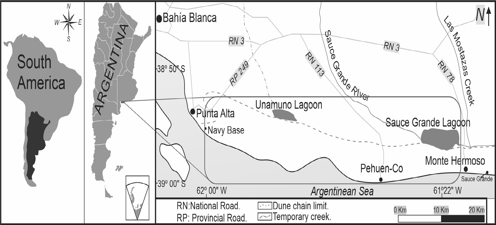
The present study is carried out in the coastal dune chain of Buenos Aires that is developed over the Atlantic coast of Argentina, between the city of Monte Hermoso and Naval Base Baterías (Punta Alta) in the southwest of the province of Buenos Aires. They are part of the coastal hydrogeological environment [1] which also warns that in Argentina; about 50% of the drinking water supply is of subterranean origin. The urban centers settled in this coastal sector are the seaside towns of Pehuen Có and Sauce Grande and the city of Monte Hermoso all of which have a stable population of about 11,000 inhabitants combined [2], although it increases significantly during the summer period.
This study deals with the lithostratigraphic and hydrogeological conditions of the phreatic aquifer of the region and the anthropic activities that condition the quality of water and its potential uses. Impacts of anthropogenic origin are identified and differentiated from those associated to the natural origin of water quality. The objective is to contribute to hydrogeological knowledge to support proper groundwater management and sustainable use of the resource.
Following Foster [3], who defines the natural threats to water quality, the presence of Fluorine and Arsenic is recognized, linked to the depth of the catchment and to vertical changes of the lithological and hydrodynamic conditions of the system. Soluble trace elements such iron and manganese have also been detected, which give the water undesirable organoleptic properties (odor and color) leading to social rejection of the supply source. In addition, potentially contaminating activities are identified on the surface, such as the presence of farmpens, cesspools and privately owned groundwater catchments, without adequate sanitary protection. Factors that condition water quality must be considered in a rational and sustainable exploitation of the resource and reliability of water supply.
Methodology
Field work included measurement of depth of the phreatic level, physico-chemical characteristics of water in-situ with a portable multiparametric sensor and water sampling for hydrochemical analysis. Background information and lithological registries of drillings were analysed. Another field activity consisted in the execution of electrical resistivity tomographies (ERT) with an automatic resistivity meter model ARES, GF Instruments. Wenner and Schlumberger type arrays were chosen in order to obtain a better horizontal and vertical resolution of the underground. The ERTs were made with lengths between 129.6 m to 235 m with an electrode separation of 2.7 m to 5 m. RES2DINV inversion software was used.
Study Area
The study area is located on the Atlantic coast of the province of Buenos Aires, Argentina. It extends from the city of Monte Hermoso at 38º59’44” S and 61º12’2” W to 38º55’37” S and 62º 3’37” W, Punta Alta to the west. It includes the towns of Pehuen Có and Sauce Grande covering an approximate surface of 500 Km2 (Figure 1).
Physical Environment
The zone of interest has a temperate climate, typical of mid-latitudes. Precipitation data from the rural area of Pehuen Co indicate an average precipitation value of 732 mm/year and an average annual temperature of 15.5 ºC (59.9 ºF). The inter-annual distribution of rainfall indicates that it occurs mainly in early autumn and early spring, while winter and summer are the dry seasons. The potential evapotranspiration calculated by the Thornthwaite method [4] gives a value of 779.88 mm/year, which indicates a predominance of hydric deficit.
In the coastal area of the southwest of Buenos Aires, the main geoform is a coastal dune chain with an east-west orientation. It is bordered to the north by the Pampean plain and to the south by the Atlantic sea. In the northern limit (plain), flooded sectors are generated, related to the rise of the water table. The sector is characterized by altitudes ranging from 0 to 40 meters above sea level and presents an important dune chain or coastal dunes, mobile or active, semi-fixed and fixed by vegetation.
The dune chain develops behind the beach zones. The sand dunes have variable shape and height and the frequent width of the chains varies from 3 to 5 km from the coast. It is a sandy relict generated by the action of the sea on the “Pampean Sediments” and subsequently exposed to the action of the wind [1]. Presence of water in the interdune areas is a characteristic of these environments. This situation generates wetlands that have been hydrologically typified by Ruffo, et al. [5].
Geology and Hydrogeology
The existing deposits are genetically linked to the variations in sea level that occurred during the Neogene period, with deposits of both continental and marine origin [6]. The extensive sand cover limits the oldest outcrops to sectors of coastal cliffs or fluvial terraces, which have been analysed by several authors [7, 8, 9, 10]. Two aquifers are recognized at a shallow depth. The deepest of them corresponds to the Monte Hermoso Formation [10], composed mostly of clayey siltstones, sandy siltstones and fine sandstones, that can be correlated with the “Pampean Sediments” [9]. This last formation presents an aquiferous/ acuitard behaviour, hosting fresh to brackish water with average electrical conductivities of 2000 µS/cm, of good to regular chemical quality, with high Fluorine and Arsenic tenors. Hydrodynamically, a regional flow of north-south direction is recognized, which ends its path discharging into the sea. The recharge occurs both in the Pampean plain due to excess water from rainfall and in the coastal chain by hydraulic connection with the upper sandy sediments.
Overlying the above, there is an aquifer, lodged in sediments and psamitic rocks belonging to the Puerto Belgrano (Upper Pleistocene) and Punta Tejada (Upper Pleistocene-Middle Holocene) formations [10] and to the modern deposits that form the coastal dunes. It houses fresh water (average electrical conductivity is 700 µS/cm) suitable for human consumption, constituting the main source of supply for the sector’s seaside localities. The recharge depends on the excess water generated by rainfall. The water table smoothly follow the topographic features, locally recognizing domes with divergent radial flows towards the inter-dune sectors (Figure 2). According to the information obtained in the well census, the unsaturated zone has an average thickness of 5 m, with maximums between 15 m and 16 m at the top of the dunes. Regionally, two groundwater flows are recognized, towards the northern sector (plain) and the other towards the south (sea). Thus two interfaces are generated: freshwater-brackish water in the northern sector and freshwater-saltwater in the southern sector.
![Figure 2: Hydrogeographic scheme. From Ruffo [5].](/fulltextimages/7964/fig_2.png)
Stratigraphic Factors That Condition the Hydrochemistry of Groundwater
Monte Hermoso Formation (Upper Miocene – Lower Pliocene)
The stratigraphic position and lateral relations of the geological units are related to changes in sea level and the progressive migration of the ancient valleys of the Sauce Grande River.
The oldest sediments considered, correspond to the sandy and clayey silts of the Monte Hermoso Formation [10] of the Upper Tertiary, informally called “Pampean Sediments”. They have aquifer-acuitard behaviour; carry waters with salinity between 2 and 10 g/L and variable natural contents of F and As [1]. Drilling for water supply is interrupted when this formation is reached and water for human consumption is extracted from the saturated zone hosted in the overlying sediments.
Hydrochemical analysis of drillings that reach the first meters of the Monte Hermoso Fm. indicate that they carry freshwater with fluoride and arsenic tenors typical of the “Pampean Sediments”. The depth at which these sediments appear is variable. They outcrop in the Farola Monte Hermoso cliffs, deepening towards the east and west, as a result of the sedimentary processes that originated the more modern sedimentary cover.
Post-Pampean Sediments (Lower Miocene – Holocene)
Overlying the above, there is a phreatic aquifer, hosted in sediments and psammitic rocks of the Puerto Belgrano and Punta Tejada formations and in modern deposits that form the coastal dune chain. The sedimentary column has been recognized based on cutting analysis of drillings conducted at the site. Above the “Pampean Sediments” it is common to identify marine levels of sand with fossilized shell remains, which are assigned to the Holocene [11]. This package of conchiferous sands is hydraulically connected with the sands of the dunes that cover it and are carriers of low salinity water, suitable for human consumption.
Fixed, Semi-fixed and mobile dunes (Upper - Middle Holocene)
Under this denomination, the most recent sandy deposits are grouped. In general two types of dunes are recognized:
the oldest ones, fixed-semifixed by vegetation and the mobile ones currently active. These units have high permeability and effective porosity, which gives them great capacity to absorb rainwater, which characterizes them as preferential sectors for recharging on the coastal environment. They are carriers of low salinity water, suitable for human consumption, but its lithological characteristics determine a high intrinsic vulnerability to groundwater contamination.
A particularity of these deposits is the presence of rich levels of Iron and Manganese in areas of Monte Hermoso and Sauce Grande. The maximum measured Fe content is 11.2 mg/L (maximum allowed according to CAA being 0.30 mg/L), while Mn is 1.91 mg/L (0.10 mg/L allowed).) The drillings that exploit these levels extract colored water with an unpleasant odor and taste.
Exploration of Aquifer Levels
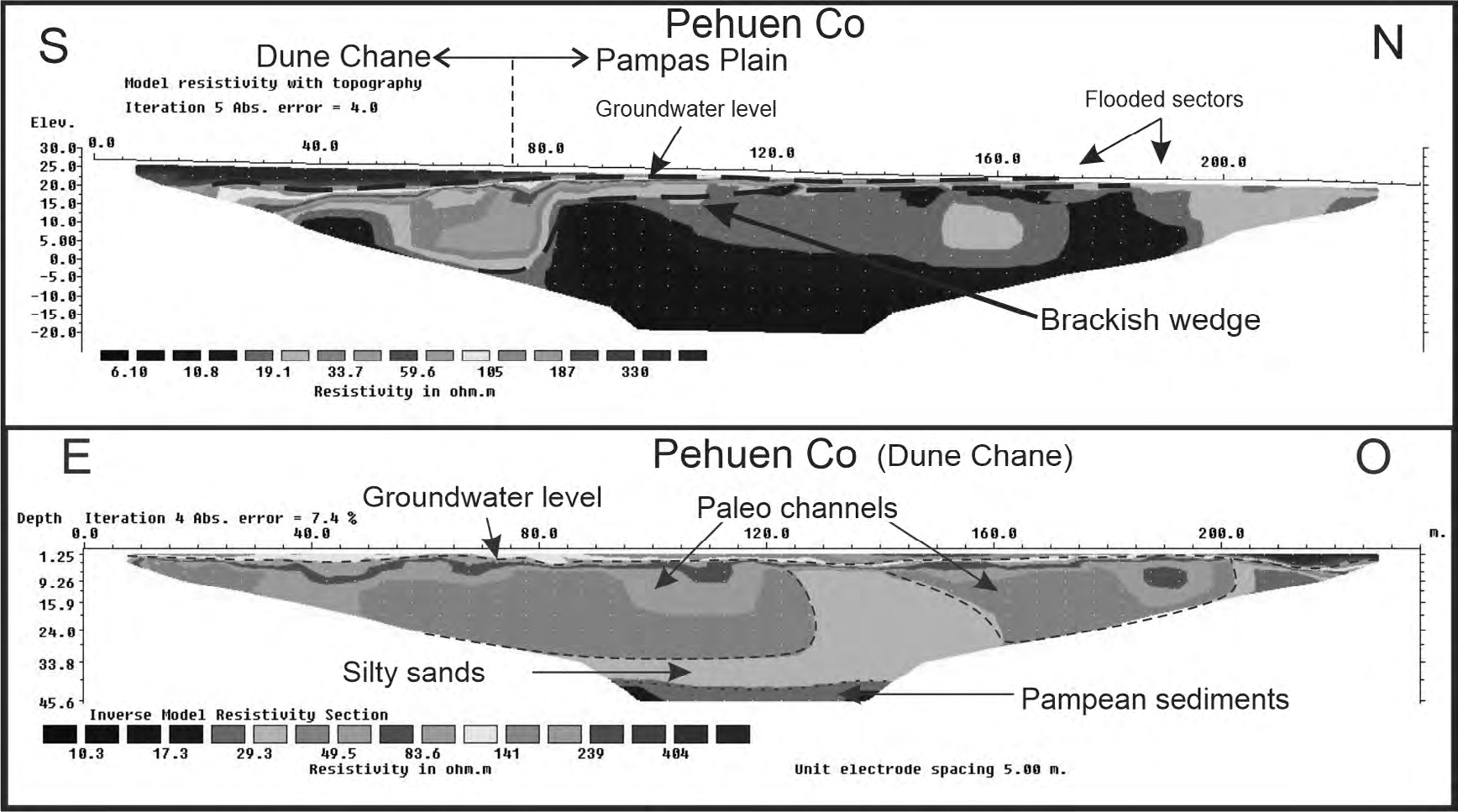
As it has been already mentioned, the presence of the “Pampean Sediments” represents a conditioning factor in the quality of the groundwater. Drillings that reach a few meters into them are affected by an increase in Fluoride and Arsenic compared to the water hosted in the psamitic aquifer. That is why, determining in an indirect way the top of these sediments, before drilling a well, is of the utmost importance for an adequate and sustainable exploitation. In this sense, the resistive contrast, product of the lithological and salinity differences of the hosted water, between the Pampean sediments and the sandy package that overlies it, is ideal for the application of geophysical methods (Figure 3).
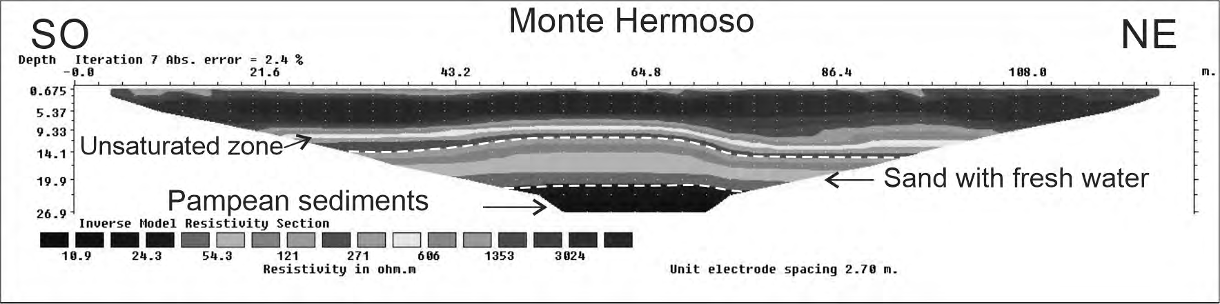
The electrical resistivity tomography (ERT), has not only allowed the identification of the “Pampean Sediments” top, but also lateral variations, saline levels and zones with paleochannel are evidenced with this technique (Figure 4).
Anthropic Factors
The presence of anthropogenic activities can lead to a degradation of the natural characteristics of water. In the study area only the impact of domestic activity (not industrial, agricultural or livestock) is recognized.
The city of Monte Hermoso is the most important urban area in the sector. It has a stable population of 6494 inhabitants [2] and increases that number to approximately 70,000 during the summer season. It has 70% of its urban area covered by sewage service, while 30% uses cesspits or absorbent wells for the discharge of domestic effluents. Sewage is derived to decanting pools and then dumped into the Sauce Grande River [12]. Urban solid waste is deposited in a sanitary landfill, which has geo-membranes to prevent leachates from affecting the aquifer. Pehuen Co town has less than 600 permanent inhabitants, reaching 10,000 during the summer [13]. Lacking sewage services, 100% of the houses dump their liquid waste into the subsoil. The urban solid waste is deposited in an open-air dump, on the sands of the dune chain and without any protection to prevent leachate migration.
These two sectors are located entirely on the coastal dune chain and use the phreatic aquifer in the sands as their only source of water supply. Agriculture is an almost absent activity in the dune chain. Certain activities identified in the area could be classified as “human-pollutant threats” these activities are those related to contamination processes derived from sewage effluents or open air dumps and spills, which leach and contaminate aquifers, as well as liquid and solid waste deposits of domestic origin.
The dominant lithology type, the unconfined character of the aquifer and the depth to the water table classify it as an aquifer with a high vulnerability index [14]. The analysis of the pollutant loads identified in the city of Monte Hermoso [15] added to the intrinsic vulnerability of the groundwater; show a high pollution risk [14]. The influence of household liquid waste is evidenced by the presence of total coliforms and pseudomonas bacteria in the groundwater extracted from urban wells (Table 1). Although no analytical data is available, the nitrate content should be high because of its direct link to the degradation of organic matter. The seasonal increase of the population, in sectors without sanitation works, undoubtedly influences the quality of the water resource. Thus, during the summer, the wells in the central area of Pehuen Co have an unpleasant smell and taste.
| Maximum allowed | Maximum measured | |
|---|---|---|
| Total Coliforms | ≤ 3 MNP /100 ml | > 2400 /100 ml |
| Pseudomonas | Absence in 100 ml | Pseudomonas Positive |
Table 1: Bacteriological analysis in the town of Pehuen Co (Source: Municipality of Coronel Rosales).
The results of groundwater sampling allow us to affirm that, in general, the values of nitrates measured in the phreatic aquifer of the dune chain, do not exceed the maximum established by the C.A.A (45 mg/L), averaging a value of 3 mg/L.
Another anthropogenic activity that could affect the quality of the groundwater is the intensive extraction of large volumes of water during the summer period. Hypothetically, the exploitation of groundwater in coastal sectors could induce contamination by marine intrusion, resulting from the displacement of the freshwater-saltwater interface towards the continent. This situation is not observed in the area.
Discussion and Conclusion
The lack of access to drinking water is considered one of the main causes of disease in the country and the world [16] and its availability is closely related to the quality of life of the population [17].
One of the most extended aquifers in the province of Buenos Aires is the phreatic one hosted in the “Pampean Sediments”. Its main problem in terms of chemical quality is the presence of Fluorine and Arsenic. These elements, of natural origin and intimately linked to the lithology of the deposit, condition the quality of the groundwater for human consumption [18]. These sediments constitute the floor of the sands of the coastal dunes, which have a phreatic aquifer, carrying fresh water and with low to zero fluoride and arsenic content [14]. Lack of knowledge or disclosure about the configuration of the coastal aquifer system has led to inappropriate drilling. These go through the sands and reach the “Pampean Sediments”, with the consequent mixing of water and increase of the already mentioned trace elements, to the detriment of the chemical quality and its suitability for human consumption. In this sense, electrical resistivity tomographies allowed identifying preferential sectors for the drilling of wells, due to lateral variations related to changes in the hydrological characteristics of the sediments.
Active dunes, favors the burying of vegetated sectors. The decomposition of organic matter in reducing conditions would be associated with the presence in the groundwater of high concentrations of Iron and Manganese such as those detected in sectors of Monte Hermoso and Sauce Grande. A high concentration of these metals in groundwater alters its organoleptic characteristics, causing social rejection of the resource.
In the study area, point contamination due to the discharge of organic domestic effluents into cesspools or absorbent wells was detected.
The high intrinsic vulnerability of the phreatic aquifer requires adequate land use planning to minimize the risk of groundwater contamination. Total or partial lack of adequate sanitation works (sewage system, disposal of urban solid waste in controlled sites and conditioned for this purpose, effluent pools) in urban areas of the sector results in a “High” contamination risk. [14].
The significant increase in the demand for fresh water during the summer season and the consequent increase in waste, both liquid and solid, make it necessary to have a management plan according to the sector, with a view to preserving the quality and quantity of water resources. In this way, management strategies must take into account not only the controlled occupation of the territory, but also the hydrogeological characteristics of the area.
Hydrogeological knowledge of the subsoil and groundwater is essential for the proper design of well fields and for generating protection strategies. The sustainability of groundwater resources in coastal urban areas will depend on proper water management.
References
-
M Auge (2004) Regiones Hidrogeológicas, República Argentina y provincias de Buenos Aires, Mendoza y Santa Fe. Buenos Aires, Universidad de Buenos Aires.
-
INDEC (2010) Censo Nacional de Población, Hogares y Viviendas. https://www.indec.gob.
-
Foster S, Kemper K, Tuinhof A, Koundouri P, Nanni M, et al. (2006) Amenazas naturales a la calidad del agua subterránea. Evitar problemas y formular estrategias de mitigación. Gestión sustentable del agua subterránea. Banco Mundial, programa asociado de la GPW. Serie de notas informativas, nota 14. DIN 18910, Wärmeschutz geschlossener Ställe, Deutsches Institut für Normung e.V.
-
Thornthwaite CW (1948) An approach toward a rational classification of climate. Geologic Rev 38(1): 55-94.
-
Ruffo G, Albouy R, Bastianelli N, Carrica J (2019) Humedales en la franja de médanos costeros entre Monte Hermoso y Pehuen Có, provincia de Buenos Aires, Argentina. Tipificación hidrológica. Boletín Geológico y Minero de España (en prensa).
-
Aramayo SA, Schillizi RA, Gutiérrez Téllez BM (2002) Evolución paleoambiental del Cuaternario en la Costa Atlántica del sur de la provincia de Buenos Aires, Argentina. Revista de la Sociedad Geológica de España, 15(1-2): 95-104.
-
Ameghino F (1889) Contribución al conocimiento de los mamíferos fósiles de la República Argentina. Actas de la Academia Nacional de Ciencias de Córdoba, Bay. StMWi, Energie-Atlas, 6: 1-1027. http://www.energieatlas. bayern.de/index.html.
-
Ameghino F (1898) Synopsis geológico-paleontológica. Segundo Censo Nacional, Tomo I, pp: 113-225.
-
Fidalgo F, De Francesco FO, Pascual R (1975) Geología superficial de la llanura bonaerense. Relatorio del VI Congreso Geológico Argentino. Bahía Blanca pp: 103- 108.
-
Zavala C (1993) Estratigrafía de la localidad de la Farola de Monte Hermoso (Plioceno- Reciente). Provincia de Buenos Aires. XII Congreso Geológico Argentino y II Congreso de Exploración de Hidrocarburos Actas Tomo II pp: 228-235.
-
Farinati E, Spagnuolo J, Aliotta S (2002) Bioerosión en micromoluscos holocenos del estuario de Bahía Blanca, Argentina. AMEGHINIANA, Rev Asoc Paleontol Argentina 43(1): 45-54.
-
Di Martino C, Albouy R, Cifuentes O, Marcos A (2014) El acuífero costero de Monte Hermoso, Argentina. Generalidad. Recurso y reserva. Revista de Geología Aplicada a la Ingeniería y al Ambiente 33: 43-51.
-
Revista Hábitat (2014) Hábitat. Publicación anual de la Sociedad de Fomento “Amigos de Pehuen-Có”, pp: 42.
-
Ruffo G, Lafont D, Carbajo M, Albouy R, Lexow C (2019) Peligro de contaminación del acuífero freático en la localidad balnearia de Monte Hermoso (provincia de Buenos Aires). Revista de Geología Aplicada a la Ingeniería y al Ambiente 42: 15-22.
-
Di Martino LC, Lafont D, Albouy R, Marcos A (2016) Caracterización de la carga contaminante al acuífero freático, fuente de abastecimiento de la localidad de Monte Hermoso. IX Congreso Argentino de Hidrogeología y VII Seminario Hispano- Latinoamericano Sobre Temas Actuales de la Hidrología Subterránea. Catamarca, Argentina.
-
Peranovich (2019) Enfermedades transmitidas por el agua en Argentina y Brasil a principios del siglo XXI. Saude soc., São Paulo, Brasil, 28(2).
-
UNESCO. WWAP (Programa Mundial de Evaluación de los Recursos Hídricos de la UNESCO) (2019) Informe Mundial de las Naciones Unidas sobre el desarrollo de los recursos hídricos 2019: No dejar a nadie atrás. París.
-
Puntoriero MA, Volpedo A, Fernández CA (2014) Riesgo para la población rural en zonas con alto contenido de arsénico. Acta Toxicológica Argentina 22(1): 15-22.
- Lessons to Learn: Trees are More than the Lungs of the World
- Community Forestry Enterprises as a Model for Sustainable Forest Development: The Case Of The "Baja Tarahumara" in Chihuahua, Mexico
- Ecological and Socio-Economic Impacts of Chromolaena odorata and Mesosphaerum suaveolens, Two Invasive Alien Species in Central and Southern Benin, West Africa
- Epigenetic Sustainability: Modeling the Human Factor as a Natural Resource through Science 4.0 and the NR3C1 Biological Pilot
- Growth-at-Risk: A Framework for Assessing Economic Vulnerability
- The Rural Territory as a Socioecological System for the Management of Public Policy for Sustainable Rural Development