Land use/Land Cover Dynamics in Pioneer Fronts and Implications on Livelihoods: Insights from Nkuh and Nkuv on the Bui Plateau
Land use dynamics in pioneer fronts in Sub-Saharan Africa is recurrent; yet, stakeholder interests and the various changes in land-use practices are still to be fully mainstreamed in resource use practices. The implications for livelihood improvement are indicative of the attracting force of these areas to different stakeholders. This study sets out to: 1. Map land use and land cover change in Nkuh and Nkuv pioneer fronts in the Bui Plateau; 2. Identify stakeholders and interests in pioneer fronts; 3. Understand land use change practices and implications for livelihoods. The study used diachronic analysis accompanied by 7 focus group discussions, 9 key informant interviews across native authorities and some government delegations on thematic analysis and narratives. The results revealed that small agroplantations are the major land-use changes from the existing rangelands and remnants of natural forests. Farmers from neighboring villages have migrated and settled in pioneer fronts, practicing agriculture through expansion, stabilization and consolidation. Diversification and adoption of new techniques like agro-forestry, agro-plantations (oil palms, fruit trees, cocoa) is growing amongst farmers, especially among return migrants, bureaucrats and land-use change/ land-use practices have important implication for livelihood improvement for the population implicated with an increase in output. Further studies can focus on how local endogenous processes and power asymmetries can improve resource use outcomes.
Introduction
Pioneer fronts constitute a major phenomenon of land occupation dynamics. Pioneer fronts are not empty spaces as they were occupied in the past by societies that were not ‘modern’, sent away from their land of origin [1]. These are ways of freely appropriating land at the borders of already exploited lands where thousands of people occupy land in an organized or in a spontaneous manner; as such, creating new territories [2]. Pioneer fronts are put in place as a response to a genuine need expressed by populations who are the initiators or are aided by stakeholders. Most often, pioneer fronts are put in place to solve the problem of land scarcity, to unclog overpopulated zones, to access new fertile soils, new high yielding crops and new working conditions. Thales M, et al. [3] added that pioneer fronts can be classified as consolidated territories focused on the intensification of agricultural practices, or under expansion, through a strategy of occupation executed through expansion, stabilization and consolidation. Since 1893, the concept of the frontier was first used by Frederick Turner in defining American society’s expansion. It was been formulated by Pierre Monbeig with terminologies like the pioneer fringe, pioneer march and pioneer front Monbeig P, et al. [4]. Context-specific cases have been employed for space development with much relevance for land use/cover change. The spatial limits of land cover/use can be represented for different stages in evolution [3, 5, 6]. There is a relationship between population growth and land use/land cover changes [7]. Land use dynamics is a conversion of land from one form to another. These changes involve modifications that affect either directly or indirectly the natural habitat and this influences the environment [8]. Ellis E, et al. [9] expressed land use as a complicated term, where, natural scientists define it in terms of syndromes of human activities and social scientists and land managers define it more broadly to include the social and economic purposes and contexts for and within which lands are managed or not. Land-use changes involve the transformation of diverse land-use activities due to population increase and economic development [10]. Land use is denoted as any form of activity that the land is put to, such as building construction, forestry and agriculture, while land cover implies the physical or natural state of the Earth’s surface including water, vegetation, soil and /or artificial structures [9]. Land use dynamics are inevitable phenomena, which occur on a temporal and/or permanent basis. These changes are necessary for economic development and social progress but often come at a substantial cost to the environment and resources [11, 12].
Changes in land use and land cover are not a new phenomenon. It constitutes an important part of the spatio- temporal change. Land use and land cover dynamics/ changes have existed several years ago and are the direct and indirect consequences of human actions. Land use and land cover change also known as land change is a common term for the modification of the Earth’s terrestrial surface by human beings [9]. There is high variability in time and space in biophysical environments, socioeconomic activities, and cultural contexts that are associated with land-use change [13]. Land change refers to changes in land cover or land use; land change is measured by comparing land cover/land use at two or more points in time [14]. Transforming one land cover type to another is one of the most visible and rapid changes that the earth is experiencing and these transformations have intense social and environmental bearings at multiple scales [15]. Land use/land cover dynamics are very remarkable on pioneer fronts frequently caused by human actions. Population movement is the utmost imperative demographic factor causing land-use / land change for past decades [16, 17]. In Sub-Saharan Africa, changes in land use in pioneer fronts are largely driven by smallholder farmers for different ends to improve livelihoods. Natural resource frontiers attract a lot of interest. In tropical countries, they could be described as ‘natural resource battle fields’; they are characterized by competition and conflicts, arising from diverse actors’ interests [18]. While these changes have been characterized in Cameroon, in the Bui Plateau, we set out to identify land-use change, stakeholders, drivers of change and implications on livelihoods in pioneer fronts.
The main economic activity in the Bui Plateau is agriculture, which is mostly subsistence. The population depends on agricultural activities for livelihood; this implies that their main resource is the land. Nevertheless, with the fast-increasing population in this area, there is a scarcity of arable land to meet the demands of the increasing population. This major drive, caused populations to move from their original sites to the ‘new lands’ of Nkuh and Nkuv (pioneer fronts) within the plateau to occupy and put them into use. Anthropogenic activities instigate pressure on the ‘new lands’ leading to land use and land cover dynamics. Subsequently, this study aims to
- Map out land-use change,
- Identify key stakeholders and resource use practices and
- Bring out resource use implications for livelihood in the context of natural resource management.
Methodology
Study sites
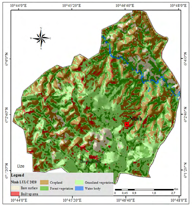
The study sites fall within Bui Division that forms part of the Western Highlands of Cameroon. It has high population densities of over 100 pers/km2 and agriculture remains the mainstay of the people. It has cool temperatures (21ºC on annual average but with distinct differences according to altitude, 800-3000m), and a moderate dry season of four to five months from November to March, which ensures a rich vegetation year-round [19, 20]. There are rich grasslands on the plateau, inter-montane plains and wooded valleys [21]. Nkuv and Nkuh are new agricultural areas situated at relatively lower altitudes (Nkuv-930m and Nkuh-780m) with warmer temperatures averaging 24ºC. While Nkuv a new farming zone is located southeast of Kumbo Sub- Division, Nkuh is located in the southeast section of Jakiri Sub-Division (Figure 1).
Nkuv is fast becoming the main agricultural pool for the population of Kumbo town and its environs while that of Jakiri town and neighbouring villages like Mbokam and Tan has found a new farming basin in Nkuh. Nkuv and Nkuh were dominated by less intensive activities like cattle rearing, hunting, harvesting and gathering, these areas have over time welcome growing numbers of temporal and permanent residents as well as land-use change with different implications on livelihoods in these areas.
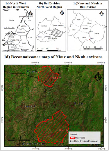
Source: National Institute of Cartography, NIC, 2017/ Landsat 8 (OLI/TIRS) 2020. Figure 1: Location of Nkuh and Nkuv on the Bui Plateau, North West Cameroon.
Methods
This study used qualitative data sources for data collection. A case study approach was used in this study with the choice of study areas predicated on the prominence and manifestation of pioneer front activities within the Bui Plateau. The selection of Nkuv and Nkuh sites was based on suggestions of land users and field manifestations gotten from preliminary field inventory. The design, test and readjustments of the research instruments took place in the months of January 2021 when preliminary studies were carried out to identify study sites and make first field contacts. The data collection phase took place during the months of June and July 2021. Seven focus group discussions (FGD) accompanied by 9 informant interviews provided first-hand field information. The FGD had 9 open-ended designed questions for group members to carefully respond to and elucidate. Seven focus group discussions were used, 4 in Nkuv and 3 in Nkuh (Table 1). Each FGD lasted for about 45 minutes to 1 hour thirty minutes and had between 8 to 12 members both women and men practicing various activities in these areas. While five of the FGD involved elderly men and women, two were composed of youths. The focus was on their land-use strategies, crop production, impacts and difficulties encountered. The FGDs were organized in Pidgin English and Lamnso languages and were facilitated by the first and second authors whose understanding of the native language eases the exchange within groups.
| Nature of Group | Location & Date | Number Present at Discussions | Focus of Discussion | |
|---|---|---|---|---|
| FGD1 | Adult men and women | Nkuv, 22/07/2017 | 9 | Land acquisition in frontier zones |
| FGD2 | Adult men, women & youths | Nkuv, 22/07/2017 | 8 | Motivations for frontier agriculture |
| FGD3 | Female & male youths | Nkuv, 22/07/2017 | 12 | Implications for frontier migration |
| FGD4 | Adult men, women & youths | Nkuv, 22/07/2012 | 9 | Motivations for frontier agriculture and impact of climate on crop production in frontier zones |
| FGD5 | Adult men & women | Nkuh, 30/07/2017 | 9 | Sources of frontier migrants |
| FGD6 | Adult men, women & youths | Nkuh, 30/07/2017 | 9 | Impact of climate on crop production in frontier zones |
| FGD7 | Female and male youths | Nkuh, 30/07/2017 | 10 | Crop diversity in frontier zones |
Table 1: Distribution of Focus Group Discussions.
From the FGD, key informants were suggested by group members for interviews. Three key informant farmers were interviewed in Nkuh and two in Nkuv on key themes such as land accessibility, reasons for such dynamics, implications of land use and challenges faced. Also, Delegates of the Ministry of Agriculture and Rural Development in Jakiri and Kumbo, as well as the Mayors for Kumbo and Jakiri municipalities. Through their narratives, detailed insights were gotten for analysis. Interviews lasted between 30 minutes to about an hour while keynotes and audio recorders were used in recording information. This information was transcribed into extracts for retrieval and analyzed following narratives, thematic and frameworks on key themes relating to motivations for interest in such areas, access to land, methods of cultivation, production and implications with the various challenges faced. Also, field photos were taken to complement primary data collected on empirical shreds of evidence of land-use changes and strategies. Satellite images: Landsat 4 Thematic Mapper ™1988 and Landsat 8 (OLI/TIRS)2020 were used for a diachronic analysis of over 30 years from 1988 to 2020, the 1990s chosen as the base
year because it was the period when farmers started moving to these areas, as a result of the economic crisis of the 1980s, information derived from FGDs.
Results
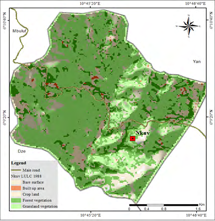
Land-use change in pioneer fronts in the Nkuv and Nkuh demonstrate evident change in land use functions, methods and diversification across the landscape. In the context of pioneer fronts in Bui plateau, the hitherto rangeland functions in grasslands have over the years ceded to agricultural land use practices notably food crop cultivation, market gardening and small agro plantations of cash crops. The change in land cover (Figures 2-5) (Table 2) for the area considered is vivid with cropland increasing over 100% in surface area from 1988-2020. There is significant dynamics in agricultural space with transformation and even modernization of the environment with increasing interventions by different stakeholders. It is appreciated on the improved practices implemented and management techniques.
Source: Landsat 4 Thematic Mapper ™1988 Source: Landsat 8 (OLI/TIRS) 2020. Figure 2: Land use/cover, Nkuv 1988.
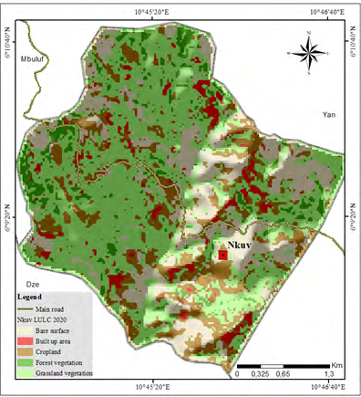
Source: Landsat 4 Thematic Mapper ™1988 Source: Landsat 8 (OLI/TIRS) 2020. Figure 3: Land use/Land cover, Nkuv 2020.
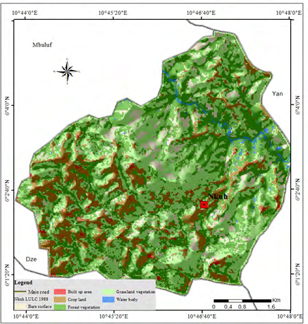
Source: Landsat 4 Thematic Mapper ™1988 Source: Landsat 8 (OLI/TIRS) 2020. Figure 4: Land use/cover classes, Nkuh, 1988.
Source: Landsat 4 Thematic Mapper ™1988 Source: Landsat 8 (OLI/TIRS) 2020. Figure 5: Land use/cover classes, Nkuh 2020.
| Nkuv (ha) | Nkuh (ha) | |||
|---|---|---|---|---|
| Land-use class | 1988 | 2020 | 1988 | 2020 |
| Bare surface | 152.1 | 312.6 | 292 | 212.3 |
| Settlement | 15.8 | 56.9 | 35.6 | 106.1 |
| Cropland | 136.4 | 257.2 | 606.8 | 1,097.10 |
| Forest | 241.2 | 86.8 | 1403.7 | 872.7 |
| Grassland | 827.8 | 659.7 | 1.401.5 | 1,437 |
| Waterbody | 28 | 28 |
Table 2: Land use change in Nkuv and Nkuh pioneer fronts (1988-2020).
Source: Landsat 4 Thematic Mapper ™1988 and Landsat 8 (OLI/TIRS) 2020. Table 2: Land use change in Nkuv and Nkuh pioneer fronts (1988-2020).
Land use/land cover change in pioneer fronts of Nkuv and Nkuh paints a picture of land-use change considered for the period 1988-2020. A vivid change in land use is the change of grassland and forest vegetation reducing and giving way to settlement and more importantly cropland. If the situation for cropland growth is considered mild for Nkuv, it is not the case for Nkuh with a rapid change in land use. In Nkuh, cropland increased from 606 ha in 1988 to 1097 ha by 2020 to the detriment of forest vegetation in inland valleys that retreated from 1403.7 ha to 872.7 ha. In Nkuv, settlement passed from 51.8 ha to 56.9 ha while it moved from 35.6 to 106.1 ha in Nkuh. Rangelands (grassland vegetation) reduced in Nkuv from 827.8 ha to 659.7 ha. Change in land use bears eloquent testimony of change in land use strategies with new land uses attributed and prioritized. It is considered as natural resource-based innovations driven by population growth, natural assets in the area embedded within social assets, institutions, land uses, cropping systems and commercialization. This trend is indicative of the new functions that land users take up considered to be more productive to respond to population pressure and land use strategies subsequently discussed.
Drivers of land-use Dynamics in pioneer fronts Agricultural Extensification
Agricultural extensification is the process of decreasing the use of capital and inputs like fertilizers, pesticides, machinery, relative to land area. From field findings, about 87% of farmers who move into Nkuh are crop farmers who farm on an individual basis. Due to lack of inputs (fertilizers, and insecticides) and capital, these farmers have that tendency to continually search for better fertile lands which increase the rate of agricultural extensification. Many farmers practise unsustainable farming methods like burning surface roughage amidst ridges (Ankara) wherein, after a few years of cultivation, loss of soil fertility forces them to move and clear additional farms elsewhere. People’s quest to acquire more farmland is substantially informed by fertile lands available in the pioneer areas in Nkuv and Nkuh. It is also fueled by reductions in crop production which farmers attribute to the declining soil fertility in old farm holdings. We found a significant influence coming from the ‘virgin’ fertile soils, population growth, land scarcity and even migration driving more people to these areas.
Different key informants explain their motivations to pioneer fronts that drive land-use dynamics. ‘… most of the farmlands we have around the villages are old and no longer produce as before. The soils are no longer fertile as before, it is difficult for us to have the means to purchase fertilizer whose price keeps increasing each year. We are bound to go to these new areas that offer new possibilities with fertile soils to acquire farms and produce greater quantities…’ FGD2/22/07/2017/Nkuv.
Productivity is derived in these areas. As affirmed by Arild A, et al. [22] many tropical farmers practice unsustainable farming methods where after a few years of cultivation, the loss of soil fertility, weeds force them to move on and clear additional forest elsewhere. Land scarcity especially fertile land is the main concern. ‘…with population growth, it increasingly becomes difficult to have access to good land for farming. When you need larger land to create bigger farms it is not easy. You have to go further, the new agricultural area of Nkuv provided an opportunity for people around and those coming right from Kumbo town to come and settle and cultivate in these areas because it is possible to acquire larger land parcels here. Those from Kumbo especially elites have the capital and they are the ones opening up large farms and small agro plantations where, over the years, they are doing trials with tree crops like fruit trees and even oil palms and cocoa …’ KII4/extension service/MINAGRI/Nkuv.
It is obvious from the views gathered in the field that scarcity of land around the major settlements and villages as well as declining productivity pushes people to these areas to acquire land for different agricultural purposes. Nkuh is situated furthest southeast of the Jakiri municipality just like Nkuv for Kumbo municipality. With population densities in the Bui Plateau generally above 100persons/km2, access to good fertile land and large landholdings is difficult. The opening of these pioneer fronts provided an excellent opportunity not only to acquire farms holdings but possibilities of migration and settlement subsequently discussed.
Migration (Farmhouses)
Migration over the years have brought new settlers; some temporarily, seasonal and later permanently. What is perceived is the fact that the more people settle, the more their land holdings are expanded upon. Most often, after new farms are open, they are visited occasionally; weekly or monthly routines and gradually farmhouses are constructed. With such new developments, farmers come and work like three days living in the farmhouses and go back to the neighboring villages. It permits farmers to invest more on land while these first seasonal settlers attract other social relations both relatives and friends to come to these pioneer fronts. Benefits from farms on livelihoods prompt some people to settle permanently with more proactive behavior and innovative strategies. This continues to fuel migration that accounts for land-use change with different livelihood implications. The population indicated the implications of migration for land use dynamics.
‘…Migration has greatly fueled land-use change in Nkuv. With the discovery of fertile cultivable land in the lowlands of Nkuv, so many migrated and settled in these areas and continue to settle. A majority of people in this area are migrants coming in from other villages…, after the first settlers, relatives and friends followed and more land is opened up. People especially elites from Kumbo have farms here, some have open integrated farms, agricultural land has attracted so many people here…’ FGD3/Nkuv/22/07/2017 ‘…very few farms existed when people started cultivating in this area, but the fertile soils cause so many people to migrate to this area to open up new farms. So many people have left Mbokam, Lip and Tan, the neighbouring villages and settled in Nkuh. Some come temporarily, some seasonal, and many have settled. With this increase in population, more farms are created and expanded upon …’ FGD5/Nkuh/July 30/2017 With the implication of major stakeholders like the Kumbo Council and the Jakiri Council in constructing roads leading to these newfound food crop basins, more people have migrated creating more cropland forming a significant part of a predominant land use map within the landscapes of Nkuh and Nkuv. Field investigation revealed that 77% of these movements cause changes in land cover and land use. Among these migrants; 70% are crop producers, 20% are rearers, 4% hunters, 7% elites and farm landlords.
According to oral narratives from 1990 till the present in Bui Division, migrants into Nkuv and Nkuh do so in search of fertile lands. There is the movement from upland villages into these lowlands (Nkuv and Nkuh). Here, land acquisition is easier than in any other area in Bui. Still on this page of oral narratives, in Bui Division, 80% of these lands are obtained from landlords (traditional chiefs with tenure rights), 20% inherited or given by friends to farm on temporarily. The different plots obtained by these farmers are used to carry out individual farm work or open group farms. According to Focus Group Discussion, Nkuv 22/7/2017, some elites from Kumbo have opened integrated farms with different crops produced; meanwhile, other migrants open up their plantations for cash crops such as palms, groundnuts, plantains and cassava. The farmhouses are set up by these farmers; thus, influencing settlement. Forest is cut for agriculture. Hunters in these lowlands are always the first to discover fertile lands. They set up traps during rainy periods and animals caught are sold fresh or rather dried up and sold in faraway markets. During dry periods, rearers set fires for pasture regeneration and hunters to facilitate trap setting. These motives of migration tie with that of FAO (2017) that is, the global goal of fighting hunger and achieving food security, reducing rural poverty and promoting the sustainable use of natural resources [23].
From findings, migration as the cause of land cover/land use dynamics in Nkuv and Nkuh shows a high volume in the movement of farmers from high elevation into lowlands. This volume decreases as distance increases from these lowlands. This has been caused by high cost, lack of information on the fertile nature of these pioneer fronts. More than 75% of land use and land cover have changed due to agricultural migration. More than 11% of forest cover has equally changed due to lumbering activities. Meanwhile, 60% of migrants into Nkuh come from villages such as Tan, Barare, Lip-Mbokam and Mbokam. Again, 20% come from Shiy, Kifom, Nsom Mantum, Ran, Koutaba, Mbo-Kijah, Mbo-Onge and Noi. The distances reduce drastically as 15% of these migrants comes from Ntseinbang, Sarkon, Waarin, Jakiri while 5% come from Mensai, Kinkahdze, Kimar, Sop and Nkarkui.
Fertile Lands for Agro-Plantations
Situated at relatively lower altitudes (900m) on gentler slopes compared to the rest of the Bui plateau (1500m), soils in these two localities present somewhat similar characteristics. Fertility is relatively higher constituting a huge potential for different types of crops produced in these areas. This has given rise to some sort of specialization in cropping than the traditional mixed cropping (maize, beans, potatoes) often found in the plateau. Some women have organized in groups and are practising farming activities like the Kira Destiny Sisters Mixed Farming Group in Nkuv
focused on the production of maize. These are a group of women that secured land and are producing maize as a cash crop with steady buyers. According to them through rural- urban linkages, they have been able to secure some steady buyers mostly poultry and piggery farmers, especially in towns like Bafoussam and some in Douala. They work in collaboration with the delegate of the Ministry of Agriculture to always get disease resistant and very productive species of maize.
The relatively low-lying topography gives a hot climate that favours the growth of smallholder cash crops (coffee, oil palms). The climate of these localities is somewhat similar to
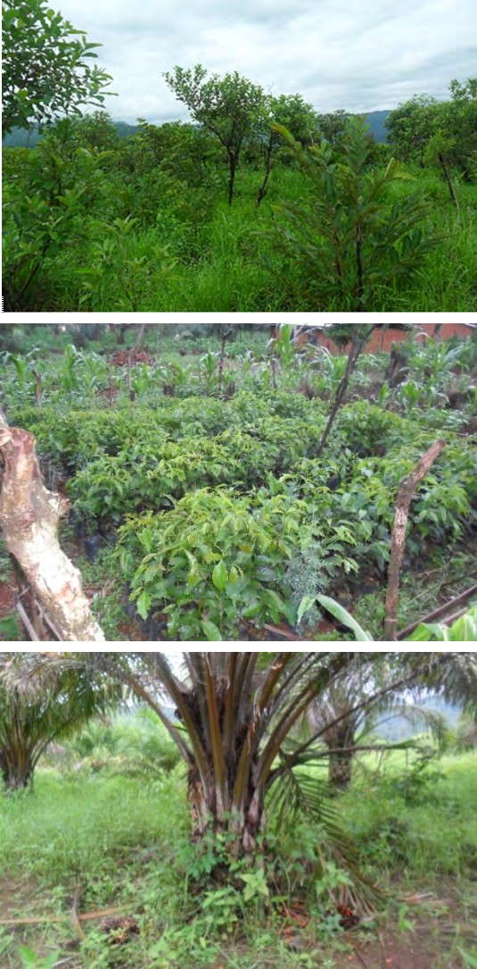
(a): Shrub savanna in the lowland of Nkuh.
(b): Coffee nursery preparation for plantations.
that which you will find in the warm low plateau of Cameroon. Unlike the rest of the Bui Plateau with cold climates, these two areas are undergoing trials and successful cultivation of smallholder cash crops like cocoa and oil palms. Key stakeholders in this rural landscape change mostly return migrants such as some rich bureaucrats and businessmen who acquire huge chunks of land ranging from 5ha to about 100ha to create these smallholder schemes. One implication of these farms on the landscape is the fact that they form a well-organized farm pattern in land use of predominant small farm holdings. These farms employ relatively more labourers around the neighbouring villages like Mbokam for the labor required in these farms (Figure 2).
(C): Small oil palm agro-plantations in Nkuh, land-use change from rangelands. Plate 1: Land use change in Nkuv and Nkuh pioneer fronts.
Pioneer fronts in the Bui plateau were areas that were before then shrub savannah used especially during the dry season as key grazing areas with some transhumance taking place, particularly for inland valleys. The opening of these areas as new agricultural grounds saw new land-use types like the case of small agro-plantations springing up. A combination of available fertile land, good climate and population demands have driven land-use change. Cognizant
of the climatic situation of these localities relative to the other areas in Bui, farmers cultivate twice (rainy season and counter season cultivation). Cereals such as Maize and beans are planted in March and April and harvested after 3 to 4 months in the months of July and August. Beans are particularly cultivated in the month of August and harvested in November and December. The high temperatures and rainfall provide for rapid maturing cycles. It was also noticed that irrigation is practised here, especially with the use of engine motor pumps for the cultivation of market gardening crops like tomatoes that are subsequently discussed under diversification taking place in these areas with different implications for livelihood.
Implications on livelihood
Through the transforming processes and changes in land use, livelihood assets and outcomes are well situated within the context of farmers’ strategies to improve existing patterns for their wellbeing. In Nkuh and Nkuv, household members use their awareness, skill and abilities to get the best of resources they access through different agricultural activities they practice meant to build sustainable livelihoods. The wealth of the natural resource base as the fertile lands constitutes a rich natural capital upon which different stakeholders invest. Farmers of all age groups are found in frontier zones: the aged in traditional food cropping systems, the youths in market gardening, and return migrants, bureaucrats and businessmen in agro-plantations. Both men and women are involved and family holdings are cultivated by household members including children. The physical capital spans across different tools from machetes, hoes to move to improve ones with the use of water pumps, tractors to improve production. The social networks and associations to which people belong also play a big role as some groups are specialized in the cultivation of maize. This is the case of the Kira Destiny Sisters, a women’s group in Nkuv. Financial capital constitutes an important asset in the livelihood framework with savings and credits made from land-use practices in these areas through thrift and loan groups (njangis) helping in input acquisition and basic needs. The implication of land-use change for livelihood is especially seen with diversification.
Diversification of Crop and Cropping Systems
It relates to the addition of new crops or the advancement of cropping systems to increase production within a particular farm. It provides an opportunity to expand production and lower the possible risk faction. Cultivation techniques/ methods refer to different ways farmers till/plough, plant, maintain, manure, mulch, irrigate, harvest and store crops. Food crop diversification into Nkuv and Nkuh has taken two dimensions; diversification from food crops to cash crops and diversification from local species into improved species. Crop diversification, which can be defined as increasing the number of crops or the varieties and hybrids of a particular crop, is a potential farm-level response to economic forces and climate variability. Food crop diversification is growing amongst farmers (note that unlike the rest of the Bui plateau where vegetables and potatoes are produced, beans, maize, sweet potatoes, soya beans, plantains, cocoyams, groundnut and especially cassava are produced in Nkuv and Nkuh and oil palm, of recent trials). Shift to cash crops is increasing cash earnings. These farm sizes are relatively very large as compared to the former production sites and output is equally high. Diversification has helped to increase their incomes; thus ameliorating the living standards of these rural dwellers. Different varieties of crops both food and cash crops are involved within these pioneer fronts. According to a farmer, ‘… cocoa was introduced in Nkuv only in 2010 but now it is being cultivated by so many farmers. Farmers are progressively integrating it in small plots while some are already harvesting from the small investments they made…’ Wirsiy Innocent, Farmer, KII, 22 July 2017.
‘… The climate of Nkuh permits us to do trials and grow crops reputed in warm areas of Cameroon. The first trials were made around 2006 by a certain Wirdzerem Elias and today, you can identify some individuals cultivating cocoa and oil palms. Some are already harvesting from those early efforts though they didn’t have very good species of hybrids of palms brought in with collaboration from the delegate of the Ministry of Agriculture and Rural Development are more promising taking less time to mature with better fruits…’ FGD6/Nkuh/ July 30/2017.
The new crops or hybrids are often introduced and cultivated in more improved cropping systems. About 87% of the population acknowledged that ‘… the opening of farms in Nkuh has brought a change in the way we used to cultivate. For us in Mbokam village, typical crop types were maize, beans and tubers like cassava and sweet potatoes. First, opening up farms in Nkuh permitted us to grow more tree crops notably fruit trees and shift to more oil palms and even cocoa. This has been facilitated by access to land and a hot climate in the lowlands. It is still easy to access hectares of land in Nkuh than in any other area around Jakiri…, the reason why many people from neighbouring villages and especially those having the means from Jakiri are acquiring huge lands or plots for farming. There are also elites like the former parliamentarian who is logging trees of economic value (like Mahogany) in the area. Land use in these areas is a bit different from the neighbouring areas…’ KII4/Shey Yensinvem Jean/July 2017/ Mangore.
Crop diversification in this subsistence farming system provides an alternative means of income generation for smallholder farmers, the majority of whom are vulnerable to climate change. Changes in resource use practices are a way of adapting to local varying instances and improving livelihoods. Crop diversification in these two localities; Nkuv and Nkuh has been a source of new hope, increasing and diversifying the sources of income to even more cash- oriented crops and tend to impact and improve livelihoods.
‘… Nkuh is the most recently opened agricultural area in Jakiri Sub-Division that just dates about some two decades ago, around the 2000s. before then, it was largely dominated by rangelands and in some areas forest, especially in some valleys. There has been a gradual opening up of farms in this area. One thing is peculiar, larger land holdings, opening up of small agro-plantations of tree crops like oil palms and cocoa and also people organizing in groups to cultivate notably maize and cassava. What has been difficult for the farmers is accessing high-quality seeds and seedlings. The delegation for the ministry of agriculture through its extension services to these areas has been working with farmers and in collaboration with some NGOs to acquire better seeds and seedlings from nurseries within and without the area …’ KII5/ Delegate /MINAGRI/Jakiri/ 27/07/2017.
From the ensuing discussion, it is clear that within the pioneer fronts, land-use change is quite evident with landmark prints in terms of change in land-use practices. Land use functions such as grazing and hunting continue to give way to farming. From grasslands, galleries and inland forests, land-use change is highly noticed with the creation of farms for maize cultivation, tubers like cassava and yams and most importantly cash crops notably oil palm and cocoa. Farmers are bound within these changing circumstances to introduce new methods as key stakeholders to accompany the new crops. Moving from seasonal crops to perennial cash crops require more land and more investment in terms of capital. Initially, some pioneers that started cultivating in these areas were people who practised hunting and discovered fertile grounds. Gradually, they informed fellow brothers and friends who followed them. Being distant with no roads, not everybody takes the risk, only a few with some elites coming in with substantial capital. Farmers go to work there and come back but because of the distance, they create farmhouses to spend at least some 3-4 working days out of the customary “country Sundays” that work is not allowed before coming back. Over the past few years, farmers have punctuated the Nkuh area with small farm huts and a few individuals have settled in this ground. In Nkuv, the situation is a little bit different; it is already a settled small village that keeps growing rapidly as it keeps attracting farmers. Here, farmers have made huge impacts on land use. It has attracted so many stakeholders whose interests even conflict over land use that is subsequently discussed.
According to responses obtained from FGDs notably by farmers on land-use strategies, a majority have made changes about soil improvement, while close to 80% of the farmers acknowledged having made changes on crop varieties and even on their cropping systems (Table 2). About half of the participants in our FGD made changes to agroforestry, planting more legumes and fruit trees. Virtually, mixed cropping is largely practiced by all the farmers. It is commonplace to see a mixed farm of tubers and cereals in the same plot. Most at times tubers like cassava are planted at the edges of ridges. Farmers also said they have changed their planting techniques in response to climate changes. These land-use changes are worth investing in because in these new areas when you apply the right techniques you get the best yields.
| Practices | Old System | New System |
|---|---|---|
| Home gardening | Low economic value & or variety trees like kolanuts | High economic value trees and or variety: mangoes, plums, apple, guava, pear, orange |
| Farm trees | Fuelwood trees | Legumes, Lucaena leucocephala |
| Hedges, live fencing & boundary markers | Cypress, eucalypts | Eucalypts, legumes |
| Forest farming | Indigenous trees | Small scale agro-plantations of oil palm, cocoa, pears |
| Land preparation techniques | Slash and burn, ‘ankara’, ridge formation, irregular planting in spacing | Slash and mulch, clearing, ridge formation, use of herbicides, pesticides, planting at regular intervals/spacing, irrigation and market gardening |
| Maintenance & inputs | Weeding | Weeding, mulching, moulding, compost manure, chemical fertilizers |
| Storage | Barns, bags | Storage houses, use of atelic powder, hermetic storage, maize barns, semi- transformation |
Source: Field inventory by Authors, 2017. Table 2: Evolving agricultural practices in cropping systems in pioneer fronts.
Mixed cropping is widely practiced where maize occupies the lower edge of the ridge this year and the upper edge the other year, and vice versa for beans. Cassava is fondly found in a mixed farm with beans and maize but after their harvest, cassava remains in the farms during the dry season. This technique, however, produces an increased farm yield as declared by many farmers. As a farmer narrates ‘… it produces an increased yield with healthy crops compared with that from haphazard planting of crops…’. Nonetheless, after maize is harvested in July, beans are cultivated in a sort of mono-cropping to be harvested in November.
Drought-tolerant fruit species such as Mangifera indica and Carica papaya were more commonly planted, while others such as Musa spp., Citrus spp., and guava are grown in areas with improved soil water regimes, either through runoff concentration or in large planting pits. Agroforestry has been more of adoption of locally propagated techniques consolidated by climate and continuous search for survival strategies by farmers. This has helped to catch up with the shortage of land, enhance soil fertility, provide income between farming seasons and cover-up food shortage.
The diversification from food crops into cash crops is carried out variedly and allows expanding cash crop production in Nkuv and Nkuh pioneer fronts. These newly introduced cash crops include; plantain, oil palm, banana, Arabica coffee, cocoa, yams and tomatoes. There has been massive diversification by farmers from local species to improved species. Some of these improved species include; Irish potatoes, maize, beans, cabbage, onions and tomatoes. These species are described by farmers as high yielding because of their ability to resist pests and diseases. From field data gathered from the delegation of the Ministry of Agriculture and rural development, some of the newly introduced improved crop species or hybrids are maize (Pannar), beans (MIDENO), cabbage (Gloria and African Cross), tomatoes (Heinz, Roma, VF, Tima), soybeans (Glycino max), watermelon (Black King f1, Kaolack) and onion (Persil, Red Creole Vikima, Gandiol, Seminis Red Creole). These improved species of food crops yield greater output thereby increasing the income and standards of living of these producers. There has equally been an abundance of food to eat thereby reducing issues of hunger and malnutrition in this study area.
The cultivation of trees notably fruits and legumes among food crops have remarkably increased. The sequence has been between fruit trees and cereals, legumes and cereals, fruits and vegetables during the dry season, and finally legumes notably Leucaena leucocephala and vegetables especially the cultivation of onions. Some farmers practise improved tree fallows with leguminous species like Sesbania macantha, Sesban and Crotalaria sp. Insights from focus group discussions with the farmers reveal that some indigenous species are allowed within the farms when they are creating their farms. It was reported that these trees maintained in farms perform several functions such as enhancement of fertility (when trees drop their leaves, which later decompose, and by the droppings of browsing animals and some are noted for nitrogen fixation), medicinal value, preventing water loss through evapotranspiration, provide shades and micro-climate suitable for particular crops. In addition to the trees maintained in farms, it was equally observed that some tree crops were planted in farms especially fruit crops such as avocado, orange, mango and guava and cash crops such as coffee. With the possibility of cultivating during the dry season, farmers have devised ways of bringing water to the farms. The change has been from not just canalizing water from streams to farms but conveying water to farms through the emic use of water pumps applying water in the farms. Farmers, therefore, canalize water with the use of pipes and sprinklers. The sprinkler is connected to the pipe that transports water over longer distances to the farms through gravity. The water may also be transported through the use of power pumps. The sprinklers attached to the pipes freely rotate thereby sprinkling water on the farm.
Improvements in Infrastructure
Land-use change and the stream of activities in pioneer fronts in Nkuv and Nkuh open a new page for infrastructural developments in these two agricultural areas. These two areas have turned out to be the new major food crop basins of Kumbo and Jakiri Sub-Divisions respectively. With this new status, given the agricultural potentials and realizations made after the opening of these areas, the major stakeholders in the area have made tremendous efforts in infrastructural developments to facilitate crop production and improve livelihoods. The first is the opening of new roads to these areas by the councils. The Kumbo Council in its development plan programmed and constructed the Kumbo-Nkuv road, a 26 km secondary farm-to-market earth road that is annually graded and maintained by the council. Similarly, the Jakiri Council has constructed the road leading to Nkuh via Mbokam. These roads facilitate access to these areas and evacuation of farm products to the market. Traders “Buyam Sellam” come to these localities to acquire goods (notably Gari, plantains, cocoyams, beans, maize, green spices and onions) that are taken to the urban centres. Views gathered from focus group discussions highlight important infrastructural developments.
‘… The increase in the number of people settling in Nkuv and its development as the major agricultural production area of Kumbo sub-division has attracted major developments; the Kumbo Council has opened the road to Nkuv, it has constantly graded the road and constructed culverts and improved water channels to facilitate transportation of food crops from this area to the markets …’ FGD3/Nkuv/23 July/2017.
‘… Nkuh was a very enclave area, only footpaths use to go to this area, but from 2014, the Jakiri Council opened up the road to facilitate transportation to and fro from this area. This has increased production in this area and attracted more people …’ KII6/Nkuh/29 July/2017.
In Nkuh for instance, footpaths and tracts created by cars to evacuate timber from the area facilitated the tracing and construction of roads from the area. Given the difficult physical landscape leading to the area from the hills in Tan through Mbokam to Nkuh, the construction and maintenance of roads is a new relief for farmers.
Improved Access to Basic Needs
The population of Nkuv stands at over 1462 (KCDP, 2013), with over 350 men, 462 women, over 500 youths and about 150 children. These are people who have continued to settle over the recent past practising agricultural activities in the area. The Kumbo Council Development Plan allocated the status of a strict agricultural area to Nkuv for people to produce maize, beans, cocoyam, groundnuts, sweet potatoes, banana and pepper to improve their livelihoods and access to basic amenities like healthcare. While there are constraints related to capacities of households to diversify, household assets, family size, education, age, gender and access to credit resources, increased assets, investments and diversification are proving to improve access to basic needs. This is facilitated by the community participation activities and other key stakeholders like the local councils. Efforts made by local councils in improving physical capital through the construction of roads are ameliorating the activities of farmers and other actors coming to the area. This has helped to improve production as transportation eases evacuation of foodstuffs from the area and ameliorates livelihoods.
Farmer-Grazier Conflicts
Given that pioneer fronts are not empty spaces, they are just ways of appropriating land at the borders of already exploited land, the interest of resource users (in this case farmers and pastoralists) tend to conflict as new land uses are created at the expense of others (farms taking up grazing space) [24]. Though needs are met on land, access to fertile grounds and new working conditions, when not well managed by key stakeholders (the council and local indigenous authorities), it poses a lot of problems. Despite the farming benefits, pioneer fronts have not always been a silver bullet but the interest in such resource settings breeds conflicts. Kimengsi JN, et al. [25] noted that natural resource areas could be described as natural resource battlefields that are characterized by competition and conflicts, arising from diverse actors’ interests. Much of the areas considered pioneer fronts were largely rangelands and giving them as new agricultural zones meant a reduction in grazing grounds for some. Some of these areas served as transhumant grazing sites especially the inland valleys of immense importance during the dry seasons. According to the Bui divisional report of MINEPIA (2013), between 2000 and 2012, there were about 96 land dispute cases of farmer grazer conflicts with 93 of them involved with crop damages in the Kumbo Sub-Division. Farmers in Nkuh noted that between 2015 and 2017, there were about 17 cases of boundary demarcation problems among farmers and pastoralists.
The causes of these encroachments are many and can be grouped under human and/or physical. The physical factors include; rugged relief, soils, unfertile soils, vegetation and climate variations, while the human and economic factors include; persistent increase in population, free-range, and bush fires. There are institutional problems in these resource areas or pioneer fronts. First, the local council recognizes these areas as new agricultural zones without good cartography of the extent and delimitation of the allocated areas. The indigenous authorities; traditional chiefs ‘Taa Ngven’ vested with customary rights to distribute land do so without the participatory involvement of pastoralists and other stakeholders. While state and customary tenure overlap, there is the failure of institutions in mapping and allocating land in a participatory manner to effectively manage interest and reduce conflicts. The first occupants amassed land but later distributed it to others. Nevertheless, concerted efforts are more or less present, land conflicts are recurrent as pastoralists see the creation of farms as incursions into grazing grounds as some key informants noted: ‘… farmer-grazer conflicts are common in Nkuv, we have had situations where pastoralists destroy crops with their cattle because they don’t want farmers encroaching into grazing land. In return, farmers attack, injure and kill cattle; at times, we have had open confrontations between people relating to these problems…’ KII3/Shey Wirsungnin Edward/22 July/2017 ‘… We also have issues of some people acquiring so much land, especially some people coming from the towns like a certain Modibo Saabo Yaya owning so much cattle and causing a lot of problems with farmers in Nkuv…’ FGD1/22 July/2017.
‘… The problems arise because the traditional chief allocates land to people without concerting with pastoralist; as such they are bound to agitate. More so, farmers tend to expand their farmlands because of their perception and convictions on land and land linked resources like the forest. Most of them know the native tribe-the Nso owns the land and pastoralist only came after and do not have the full tutelage overland, this brings conflict …’ KII8/Laisin Timothy Yuven/Nkuuh/28
July/2017.
It is important to note that farmer-grazier problems on land have been managed by dialogue platforms set up by the Netherlands Development corporation-SNV in the area. Efforts made by both administrative authorities, the council and local authorities have reduced conflicts between farmers and pastoralists. More impetus for stakeholders to managed land conflicts is drawn from these exertions to minimize causalities on resources.
Deforestation
Some parts of Nkuh area in Jakiri Sub-Division are still covered by tropical forests, especially along the inland valleys. But the population is rapidly cutting these forests and replacing them with crop farms. Some individuals exploit trees of high economic value like mahogany and saw to timber for the markets though highly regulated by the delegation for forestry and wildlife. Key informants noted: ‘… the inland valleys of Nkuh are still covered with remnants of the tropical forest. Some people exploit locally, especially for artisanal purposes, others are clearing the forest to create small agro plantations for oil palms. The former parliamentarian of Jakiri exploits important wood like Mahogany and some redwood…’ KII7/Nkuh/29 July/2017.
Rural Renaissance
Field investigations revealed that more than 89% of structures/equipment found in Nkuv and NKuh pioneer fronts are set up by elites who come from different towns to settle and farm either temporally or permanently. Some of these elites are retired workers or people who are residents in towns and have decided to farm in these milieus. Such structures identified in these villages included; farms, settlements, churches, roads, grinding mills, tractors, health units, improved agricultural inputs such as tools, seeds, ‘new’ knowledge, different means of transportation (vehicles, bikes, horses, donkeys), farmers stores, and provision stores. The availability of these structures/equipment leads to the amelioration of agricultural production, thus increasing income. The change in income contributes greatly to improving the livelihood of these rural dwellers. There has been improvement in eating habits, mode of dressing as well as the educational levels of these people.
Discussion
Land use dynamics is driven by different forces while pioneer fronts are ways of appropriating land at the borders of already exploited land [2]. While pioneer fronts integrate local communities in the process of meeting up needs of the growing population of land, fertile grounds and new ways of operation, the premium objective is better livelihood support. This is operationalized through significant transformations in land use in pioneer fronts especially from rangelands to different systems of cultivation. There are institutional support (both formal and informal) engaging arrangements to reorient land use in pioneer fronts in Nkuh and Nkuv. The drivers are natural (fertile land, low lying terrain, favourable climate) and human (agricultural activities, non- agricultural activities, population growth, modernization and diversification and other economic forces) [26, 27]. This is viewed in other circumstances across Sub-Saharan Africa. Human use of the tropical forest landscape is driven by social and economic forces that drive the ecological dynamics of the landscape system [28]. However, neither population nor poverty alone constitutes the sole and major underlying causes of land-cover change worldwide. Rather, peoples’ responses to economic opportunities, as mediated by institutional factors, drive land-cover changes [29].
Land-use change is always caused by multiple interacting factors originating from different levels of organization of the coupled human-environment systems. The mix of driving forces of land-use change varies in time and space, according to specific human-environment conditions. Land-use change is driven by synergetic factor combinations of resource scarcity leading to an increase in the pressure of production on resources, changing opportunities created by markets, outside policy intervention, loss of adaptive capacity, and changes in social organization and attitudes [13].
The transformations in pioneer fronts in Nkuv and Nkuh demonstrate an uplift in land-use practices, techniques, improved varieties of seed, and even the use of inputs such as fertilizers [25, 30]. With the support of structures like the Ministry of agriculture, farmers invest and manage better their land use and livelihood strategies. Rocha JC, et al. [31] note that land-use change is linked to the ‘technification’ of agriculture, which includes the use of heavy machinery, genetically modified varieties, supplemental fertilizers and pesticides evolves as well as standards for certification. This underlines the improvements made on land as a response to population growth and opportunities offered by economic forces.
Prevailing conditions have been fueled by the migration of significant indigenous populations notably farmers to provide innovative solutions for their rural development strategies. New socio-ecological systems have been built upon with dynamic interactions in Nkuv and Nkuh. Like elsewhere, migration plays an important role in land use/ land cover change [32, 33]. In the 21st century, rural dwellers have been noticed to be geographically more mobile than at any point in human history [34]. Population growth, migration into frontiers, and responses to national and international market forces result in a demand for land that produces food [28]. The unplanned migration of people and its impacts on natural resources may lead to food shortages and environmental degradation in the long run [32, 33]. This is visible in inland valley forest degradation in Nkuh. Expansion of cultivation can take place into the previously uncultivated areas or by migration into unsettled areas. The agricultural expansion thus leads to deforestation [35]. Agricultural expansion is by far the leading land-use change associated with nearly all deforestation cases [17]. Bhawana KC, et al. [32], in his study of land use and land cover change about internal migration and human settlement in the middle mountains of Nepal, revealed that there is no direct relationship between population growth and deforestation. Land-use change is accompanied by different infrastructural developments. Infrastructure development follows in the form of roads, electrification, health services and/or potable water, which attracts land seeking families, and consolidates occupation [29]. Nevertheless, Thales M, et al. [3], highlighted that strategies in pioneer fronts move from expansion, stabilization and consolidation. The socio-ecological systems in these two rural communities-Nkuv and Nkuh are subject to ongoing change and dynamics with the need for adjustment in innovative strategies and livelihood sustenance.
Conclusion
Land-use change should be rooted in institutional rules; rules that support the strategic development of targets, their implementation and the monitoring of ecological, social and economic standards. In recent decades, scientific investigations in land-use change especially when considering pioneer fronts in sub-Saharan Africa increased but lacked integration as to the constructs on land-use change. There is consensus on the drivers of change; population growth, migration, agricultural activities and other economic forces. The natural system, the social system, management as the interface of both, and the formal and informal regulations that provide the institutional framework must be well reconciled to reach defined objectives. Challenges on human population development and land-use change with a special emphasis on the implications on resource use practices and livelihoods are critical for key areas like pioneer fronts. Considering that these are areas witnessing a change from less intensive to more intensive ones, such changes should be well channeled with institutional support to ensure they successfully meet household population demands, reduce conflicts and effectively help in improving the livelihoods of resource users. Insights on natural resource exploitation in the Bui Plateau, notably in Nkuv and Nkuh pioneer fronts back the argument on the local institutional building process and adaptive management. Understanding the conditions of resource users and harnessing endogenous processes can improve resource management outcomes. Future research can investigate local power actors and land use in such areas.
References
-
Arnauld de Sartre X (2006) The Brazilian Amazon: rural world and dynamics of the pioneer fronts, FIG archives of Saint Die. Handout 3.
-
Moupou M (2010) Fronts pionniers et structuration de l’espace dans le Cameroun méridional: de nouveaux territoires en mutation rapide. Dynamiques des Campagnes Tropicales, pp: 72-96.
-
Thales M, Chapuis RP, Ruivo M (2021) Cartography of the Pioneer Fronts and Contribution to the Analysis of Deforestation in Para. Marcator 20: e20018.
-
Monbeig P (1981) Pioneer Movements in Latin America. In Frontier phenomena in tropical countries. Paris: Editions de l’IHEAL, pp: 49-57.
-
Arvor D (2009) Remote sensing study of soybean dynamics and the impact of rainfall on production in Mato Grosso (Brazil). HAL theses.
-
Arvor D, Vincent D, Margareth S, Agnes B (2013) Mapping and spatial analysis of the soybean agricultural frontier in Mato Grosso, Brazil, using remote sensing data. GeoJournal 78(5): 833-850.
-
Balgah SN (2005) Land Use and Land Cover Dynamics in Buea and Tiko Sub Divisions of Cameroon; Ph. D Thesis, Department of Geography, University of Buea, Cameroon.
-
Riebsame WE, Meyer WB, Turner BL (2006) Modeling Land Use and Land Cover as part of Global Environmental Change. Climatic Change 28: 45-64.
-
Ellis E (2007) Landuse and landcover change and climate change. The Encyclopedia of Earth pp: 1-4.
-
Zorrilla-Miras P, Palomo I, Gómez-Baggethun E, Martín- López B, Lomas PL, et al. (2014) Effects of land-use change on wetland ecosystem services: A case study in the Donana marshes (SW Spain). Landscape and Urban Planning 122: 160-174.
-
Balgah SN, Nformi BM (2017) The Implications of Land Use/Cover Dynamics on Resources Development in Tubah Sub-Division, Cameroon. Journal of the Cameroon Academy of Sciences 14(1): 71-85.
-
Balgah SN (2017) The implication of land use/land cover dynamics in Tubah Sub-Division, Cameroon. Journal of Archit Eng Tech 6(2): 204.
-
Lambin EF, Helmut J, Geist, Erika L (2003) Dynamics of land-use and land-cover change in tropical regions. Annu Rev Environ Resour 28: 205-241.
-
Hersperger AM, Gennaio MP, Verburg PH, Burgi M (2010) Linking Land Change with Driving Forces and Actors: Four Conceptual Models. Ecology and Society 15(4): 1-17.
-
Gilani H, Sohail A, Waqas AQ, Syed MA, Murtaza K (2020) Monitoring of Urban Landscape Ecology Dynamics of Islamabad Capital Territory (ICT), Pakistan, Over Four Decades (1976-2016). Land 9(4): 123.
-
Arild A, Kaimowitz D (1999) Rethinking the causes of deforestation: lessons from economic models. The World Bank Research Observer 14(1): 73-98.
-
Geist HJ, Lambin EF (2002) Proximate causes and underlying driving forces of tropical deforestation: Tropical forests are disappearing as the result of many pressures, both local and regional, acting in various combinations in different geographical locations. BioScience 52(2): 143-150.
-
Kimengsi JN, Aung PS, Pretzsch J, Haller T, Auch E (2019) Constitutionality and the co-management of Protected Areas: Reflections from Cameroon and Myanmar. International Journal of the Commons 13(2): 1003-1020.
-
Lambi C, Ndenecho EN (2010) Ecology and natural resource development in the Western Highlands of Cameroon. Issues in natural resource development. Langaa Research and Publishing Common Initiative Group, Bamenda, pp: 135.
-
Mairomi HW, Tume SJP (2021) Standardized Precipitation Index Valuation of Seasonal Transitions and Adaptation of Pastoralist to Climate Variability in Rangelands of the Bamenda Highlands of Cameroon. Journal of Ecology and Natural Resources 5(1): 1-20.
-
Mairomi HW, Ndzeidze SK, Mbih AR, Bongadzem CS (2017) Securing pastoralism rights and building participatory approaches for sustainable rangeland management in North West Cameroon. Proceedings of the World Bank Conference on Land Poverty, Protection Pastoral Production Systems. Washington, D.C.
-
Arild A (2001) Agricultural technologies and tropical deforestation center for international forestry research (CIFOR), Department of Economics and social science. Agricultural University of Norway AS, Norway, pp: 10.
-
Tume SJP, Zetem CC, Nulah SM, Ateh EN, Mbuh BK, et al. (2020) Climate Change and Food Security in the Bamenda Highlands of Cameroon. _In_: Squires VR, et al. (Eds.), Food Security and Land Use Change under Conditions of Climate Variability: A Multidimensional Perspective. Springer Cham, pp: 107-124.
-
Tume SJP, Nyuydine AR (2011) Conflicting Land Uses within the Kumbo Urban Space, Northwest Region, Cameroon. African Journal of Social Sciences 2(2): 39-53.
-
Kimengsi JN, Pretzsch J, Auch E, Balgah RA (2019) WWF’s Green Business Model in Protected area conservation and Livelihoods Sustenance in Cameroon: The need for a shift in approach?. Environment & Natural Resources Research 9(1): 9-24.
-
Tume SJP, Maghah JA (2021) Challenges to Climate Change Adaptation in the Agricultural Sector of Bui Division, North West Region, Cameroon. International Journal of Resource and Environmental Management 6(1): 55-68
-
Tume SJP, Kimengsi JN (2021) Indigenous and modern agro-based climate adaptation practices in rural Cameroon. International Journal of Environmental Studies 78(5): 1-10.
-
Fox J, Krummel J, Yarnasarn S, Ekasingh M, Podger N (1994) Land use and landscape dynamics in northern Thailand: assessing change in three upland watersheds since 1954. Ambio 24(6): 328-334.
-
Lambin EF, Turnerb BL, Helmut JG, Samuel BA, Angelsend A, et al. (2001) The causes of land-use and land-cover change: moving beyond the myths. Global Environmental Change 11(4): 261-269.
-
Tume SJP, Fogwe ZN (2018) Standardised Precipitation Index Valuation of Crop Production Responses to Climate Variability on the Bui Plateau, Northwest Cameroon. Environment and Ecology Research 7(2): 83-92.
-
Rocha JC, Baraibar MM, Deutsch L, Bremond A, Jordan S, et al. (2019) Toward understanding the dynamics of land change in Latin America: potential utility of a resilience approach for building archetypes of land systems change. Ecology and Society 24(1): 17.
-
Bhawana KC (2015) Land use and land cover change in relation to internal migration and human settlement in the middle mountains of Nepal. PhD thesis. University of the Sunshine Coast, pp: 1-67.
-
Bhawana KC, Digby R (2020) Outmigration and Land- Use Change: A Case Study from the Middle Hills of Nepal. Land 9(1): 2.
-
Mfewou A, Engwali FD, Lendzele SS (2017) From sustainable under-development in the pioneer fronts: The case of Benue agricultural production area, North Cameroon. International Journal of Research in Geography 3(1): 8-15.
-
Stéphenne N, Lambin EF (2001) A dynamic simulation model of land-use changes in Sudano-Sahelian countries of Africa (SALU). Agriculture, Ecosystems and Environment 85(1-3): 145-161.
- Lessons to Learn: Trees are More than the Lungs of the World
- Community Forestry Enterprises as a Model for Sustainable Forest Development: The Case Of The "Baja Tarahumara" in Chihuahua, Mexico
- Ecological and Socio-Economic Impacts of Chromolaena odorata and Mesosphaerum suaveolens, Two Invasive Alien Species in Central and Southern Benin, West Africa
- Epigenetic Sustainability: Modeling the Human Factor as a Natural Resource through Science 4.0 and the NR3C1 Biological Pilot
- Growth-at-Risk: A Framework for Assessing Economic Vulnerability
- The Rural Territory as a Socioecological System for the Management of Public Policy for Sustainable Rural Development