Carbon storage of Mangrove Sediments in Kibani, Eastern Niger Delta, Nigeria: Implications on the Environment
The amount of carbon stored in the mangrove sediments in Kibani area of Eastern Niger Delta was quantified. The objectives were to determine the sediment bulk density (SBD) and organic carbon concentration (%C), and estimate the amount of organic carbon stock in the top 100-cm depth of mangrove sediments and its carbon dioxide equivalent (CO2 e). A total of 312 sediment samples were collected from 24 different sampling points at seven locations. An open-cylindrical gouge auger of 100-cm length and 5-cm diameter was designed and fabricated for the purpose of sediment sampling. Field measurement, laboratory analysis, data presentation and result presentation followed the Guidelines for Forest Carbon Measurement, Monitoring and Reporting. The sediment type has a major control on the distribution of organic carbon. The lithology is a typical of mangrove forest and included peat and clay with pockets of sands. Sediment bulk density (SBD) and %C ranged from 0.95 g/cm 3 to 1.97 g/cm 3 (mean = 1.30 g/cm 3 ) and 0.9 % to 33.6 % (mean = 12.48 %) respectively. Carbon stocks ranged from 24.12 ± 15.18 Mg C ha-1 to 3245.76 ± 15.18 Mg C ha-1 (mean value = 39.80 Mg ha -1 ) while CO 2 e ranged 88.52 ± 15.18 Mg CO 2 ha-1 to 11,911.94 ± 15.18 Mg CO2 ha-1 (mean = 2,348.07 ± 15.18 Mg CO 2 ha-1). The total carbon stock of the study area was estimated at 947.78 ± 55.64 Gg C, equivalent to 3,478.36 ± 55.64 Gg CO 2 . The study revealed that 732,595.71 ± 55.64 Mg of carbon dioxide is stored in the sediments. This amount could either be removed or released to the atmosphere through forest management practices and/or degradation to exacerbate climate change and /or mitigate it. It is recommended that Niger Delta region of Nigeria should be protected against all anthropogenic-related degradation which influence the amount of carbon storage.
Introduction
Our climate is changing. This has become one of the global environmental issues. Carbon dioxide (CO2) is known to play a key role in climate change [1, 2]. Anthropogenic-related increase of greenhouse gases, CO2 in particular is the major cause of global warming, accounting for as much as three- quarters of greenhouse effect [3, 4]. Global warming drives the climate change and it has been predicted that global warming will continue for decades with its multiple negative effects being experienced by all and sundry [3]. Climate change has tremendous impacts on both humans and the environment.
Some of these impacts include severe water shortages, accentuated rise in sea level (with consequent destruction of the ecosystem, biodiversity and human economic activities), depletion of natural resources, increased occurrence of storm surges, decimation of wetlands and extreme weather events such as aggravated droughts and catastrophic floods (which cause crop damages and failure, low agricultural yields, increased desertification), higher temperature on land and sea and heat waves, variability of rainfall, shift in the geographical range of plant species, changes in the length of growing season, melting of ice sheets, snow and glacier, salt water intrusion, decreased water quality, increased sediment load, accentuated erosion, etc. [3, 4, 5, 6, 7]. Adaptation is required in order to cope with climate change. Although mitigation measures are to be pursued, attention should be given to adaptation techniques only if there is no progress in mitigation actions [8].
The mangroves are becoming relevant at the global level because of the role they play as natural carbon sinks with eventual climate change mitigation potentials [9, 10]. Researches have revealed that the mangrove sediments can play a key role in climate change mitigation [11, 12, 13, 14, 15, 16, 17, 18]. The amount of carbon that is stored in soils and/or sediments have been found to be twice the amount of carbon in the atmosphere [19]. This suggests that if carbon sequestration capacity of soils and/or sediments is enhanced, it can help to can ameliorate the effects of climate change.
Mangrove forests are among the largest organic carbon reserves which contain organic soils up to several metres deep [20]. They are a community of plant species which occupy fringy, shallow sandy or muddy areas and occur in the intertidal and shallow subtidal zones of tropical and subtropical tidal marshes [21]. Mangrove forests cover about 137,600 km2 of coastlines and span over 118 countries, contributing about 30 to 35 % to the global area of tropical wetland forest [22, 23, 24, 25]. About 20 % of the world’s mangrove forest is found in Africa which makes it the 3rd largest continent in terms of mangrove cover [14, 24, 26]. Nigeria’s mangrove forest lies within the coastal region of Niger Delta. It is the largest mangrove in Africa and the 4th largest in the world stretching along the coast and covering about nine states [23, 25, 27].
The mangrove sediments are highly vulnerable to change in land use and/or climate as significant amount of carbon stored in them could be released back to the atmosphere if the sediments are disturbed [18]. Such change in land use and/or land cover such as deforestation, conversion, degradation and afforestation are caused by land clearing, aquaculture expansion, overharvesting and development and could lead to loss of the entire belowground carbon pool of tidal wetland sediments [18, 28, 29, 30]. Deforestation is the second largest anthropogenic sources of atmospheric CO2 emissions, accounting for about 20 % of global anthropogenic CO2 [3, 4, 24, 31]. It has dual consequences in that it reduces the amount of carbon stored in mangrove sediments and releases significant amount of CO2 back to the atmosphere [26]. Owing to deforestation and other forms of forest degradation caused by oil and gas exploration/exploitation, developmental projects in coastal communities, unregulated lumbering for construction and wood carving, the mangrove forests of Niger Delta are being threatened [32, 33]. This threat can influence the amount of carbon storage and as well undermine its role in climate change mitigation [15]. The assessment of carbon storage of mangrove sediments is a key to determining the amount of CO2 released to the atmosphere via forest disturbances. It is pertinent to carry out this assessment in Niger Delta since exploration/ exploitation of crude oil and the activities of artisanal crude oil refinery have continued to release CO2 to the atmosphere while deforestation and other forms of forest degradation which have remained unabated in the region not only reduce CO2 intake but increase its release. Determining the amount of carbon stored in mangrove sediments remains the key to knowing the importance of mangrove sediments in climate change mitigation. This is important particularly in the mangrove sediments of Niger Delta where no such research has been carried out. This study assessed the carbon storage of the mangrove sediments in Kibani, Eastern Niger Delta, Nigeria. The objectives were to determine the sediment bulk density (SBD) and organic carbon concentration (%C), and estimate the amount of organic carbon stock in the top 100- cm depth of mangrove sediments and its carbon dioxide equivalent (CO2e).
Materials and Methods
Study Area
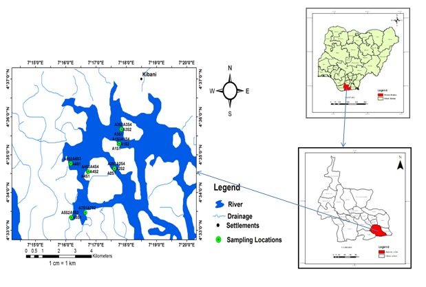
The study was carried out in Kibani tidal flats of Gokana Local Government Area of Rivers State. This area falls within the Mangrove Swamp Forest of Niger Delta, Nigeria which shares boundary with Bonny L.G.A to the west, Khana L.G.A to the north, Opobo/Nkoro L.G.A to the east and the Atlantic Ocean to the south. It lies between Latitude 40 33’ to 40 35’N and Longitude 70 16’ to 7017’E and stretches along the coastline. The tidal flat covers an area of 47.53 ha (Figure 1). The study area is characterized by a humid tropical climate with mean annual rainfall reaching 4000 mm during the peak of rainy season (July-September) while the salinity of water fluctuates seasonally reaching as high as 3.8 ‰ in the dry season and dropping to 0.5 ‰ in the rainy season [33]. The monthly temperature of air varies from 260 C to 300 C [32]. The soils are commonly referred to as “Chikoko mud” and are sandy, clayey and muddy with dark grey colour. The vegetation types include Rhizophora racemosa, Rhizophora harisona and Rhizophora mangle, Avicenia Africana and Nypa fruticans with Rhizophora genus being dominant [27, 34]. The mudflat is inundated with water during high tides.
In terms of lithology, the Niger Delta Basin contains sediments that reaches about 12,000 metres [35]. The sediments are grouped into three stratigraphic units on the basis of the ratio of sand to shale contained in the sediments and include continental (at the top), paralic and marine sediments [36, 37]. These stratigraphic units are known as Benin Formation, Agbada Formation and Akata Formation respectively [38]. Akata Formation is a basal marine shale unit deposited in prodelta environments and consists of clays and shales with minor intercalation of sands which is usually less than 30 % in composition [38]. Agbada Formation is a coastal marine sediment consisting of alternating sands and shales and represents sediments deposited in the transitional environment such as mangrove swamps, floodplain, marsh (that is, lower delta plain), coastal barrier and fluvio-marine zones. The percentage of sand in Agbada Fornation ranges from 30 % to 70 %. It is about 3000 metres thick and ranges from Paleocenee to Recent in age [38]. Benin Formation is the top layer of the depositional sequence of Niger Delta. It has a very high percentage of sand which varies from 70 % to 100 %. The coastal plain sands dominate. The sediments were deposited in the continental environment of the upper delta plain such as braided and meandering of fluvial systems.
Field Sampling
Field sampling was carried out between August 4 and 24, 2021. A total of 312 sediment samples was collected from 24 sampling points at seven locations (K1-K7; Table 1). Procedures for Forest Carbon Measurement and Monitoring specified by Kauffman JB [18] were followed. An open- cylindrical gouge auger of dimensions 100 cm long and 5 cm wide, specially designed for environmental research purposes was designed, fabricated and used in sampling (Plate 1). A systematic sampling approach was adopted. At each location, a rectangular plot was established. The number of sampling points depended on the size of the tidal flat. Sediments were sampled at depth of 100 cm. The organic litters were removed from the ground surface while the auger was inserted vertically into the ground by pushing until the top of the auger got to the level of the ground surface. The auger was turned in a clockwise direction a few times to cut through the sediment. The auger with sediment in it was gently pulled out of the ground while turning it to retrieve the sample. When pulled out, a measuring tape was used to measure the required depth intervals while a spatula knife was used to split the sample. At each sampling point, the samples were split into 13 subsamples with varying depth intervals (six 5-cm depth intervals and seven 10-cm depth intervals). The auger was disassembled and washed with water after each deployment. The sampling dates, coordinates, depth intervals, plot and sample numbers/ foil identification numbers were all recorded in the field notebook and later transferred to the field datasheet. All samples were put into pre-labelled aluminium foils, sealed and kept in core boxes in the field and were later transported to the Engineering Geology Laboratory of the Department of Geology at University of Port Harcourt, Nigeria for analysis.
| Location | Points Sampled | Sampling point ID | Latitude | Longitude | Number of Samples | |
|---|---|---|---|---|---|---|
| 1 | K1 | 4 | K1S1 | 4° 35' 17" | 7° 17' 45" | 52 |
| K1S2 | ||||||
| K1S3 | ||||||
| K1S4 | ||||||
| 2 | K2 | 4 | K2S1 | 4° 34' 38" | 7° 17' 36" | 52 |
| K2S2 | ||||||
| K2S3 | ||||||
| K2S4 | ||||||
| 3 | K3 | 4 | K3S1 | 4° 35' 40" | 7° 17' 49" | 52 |
| K3S2 | ||||||
| K3S3 | ||||||
| K3S4 | ||||||
| 4 | A4 | 4 | K4S1 | 4° 34' 33" | 7° 16' 44" | 52 |
| K4S2 | ||||||
| K4S3 | ||||||
| K4S4 | ||||||
| 5 | K5 | 3 | K5S1 | 4° 33' 20" | 7° 16' 08" | 39 |
| K5S2 | ||||||
| K5S3 | ||||||
| 6 | K6 | 3 | K6S1 | 4° 34' 45" | 7° 16' 09" | 39 |
| K6S2 | ||||||
| K6S3 | ||||||
| 7 | A7 | 2 | K7S1 | 4° 33' 28" | 7° 16' 39" | 26 |
| K7S2 |
Table 1: The Coordinates of Sampled Locations.
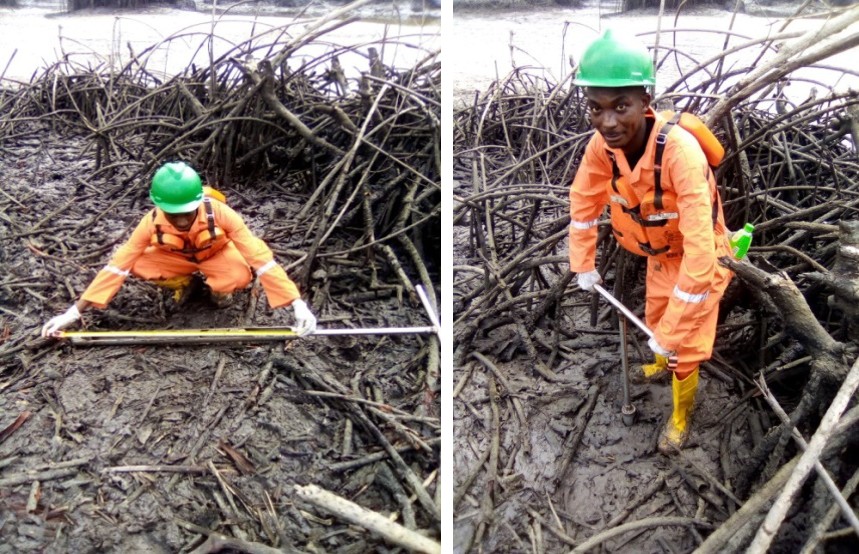
Plate 1: Field Sampling.
Data Analysis
The parameters needed to estimate the amount of carbon storage include the sediment bulk density and organic carbon concentrations at different depth intervals. The sediment samples were analysed based on standard laboratory procedures. Bulk density for each depth interval was determined standard density formula (equation 1).
Sediment bulk density = mass of sample/volume of sample ------ 1
The organic matter content in the samples was determined using the loss-on-ignition (LOI), which is a semi- quantitative method [39]. The sample was placed in a Lenton Furnace and heated to a temperature of 7500 C to destroy all the organic matter in the sediment as described by [40]. A conventional conversion factor of 0.58 was used to convert organic matter content to organic carbon concentration (%C) using equation 2 [18]. This is described by Paulsen HM [19].
%C = LOI * 0.58 --------------- 2
The carbon storage of each depth interval per hectare was estimated using equation 3 [14, 18].
Carbon stock = SBD * %C * D --------------- 3
(where SBD = sediment bulk density, %C = organic carbon concentration and D = sediment depth interval) The amount of carbon dioxide equivalent (CO2e) in different locations of the study area was estimated by multiplying the carbon stored in each location by a factor of 3.67 as described by Iticha B [41]. The factor was generated from the ratio of molecular weight of carbon dioxide (42) to carbon (12) as 1 Mg of sediment is equivalent to carbon 3.67 Mg of CO2 sequestered [42, 43]. Therefore, the equivalent CO2 (Mg) in Kibani area of Niger Delta was estimated based on the total carbon storage as shown in equation 4 [42, 43].
CO2e = 3.67 * carbon storage ------ 4
Results and Discussions
Two major parameters are important in the estimation of organic carbon stored in the sediment and they include sediment bulk density (SBD) and organic carbon concentration (%C). Sediment bulk density, %C and carbon storage significantly vary with depth and lithology; Tables 2a and 2b
| Depth interval (cm) | Average SBD (g/ cm-3) | Average %C | Average Carbon Storage (Mg C) | Average CO e 2 (Mg CO ) 2 |
|---|---|---|---|---|
| 0-5 | 1.23 | 18.40 | 122.88 | 450.97 |
| 5-10 | 1.19 | 16.20 | 191.69 | 703.50 |
| 10-15 | 1.20 | 15.10 | 268.34 | 984.81 |
| 15-20 | 1.18 | 14.60 | 338.81 | 1243.43 |
| 20-25 | 1.23 | 14.20 | 440.15 | 1615.35 |
| 25-30 | 1.22 | 13.60 | 490.97 | 1801.86 |
| 30-40 | 1.28 | 11.40 | 562.27 | 2063.53 |
| 40-50 | 1.28 | 10.80 | 669.88 | 2458.46 |
| 50-60 | 1.33 | 11.20 | 885.92 | 3251.33 |
| 60-70 | 1.37 | 11.40 | 1062.67 | 3900.00 |
| 70-80 | 1.39 | 9.40 | 1069.18 | 3923.91 |
| 80-90 | 1.44 | 8.10 | 1049.60 | 3852.03 |
| 90-100 | 1.46 | 7.30 | 1064.35 | 3906.16 |
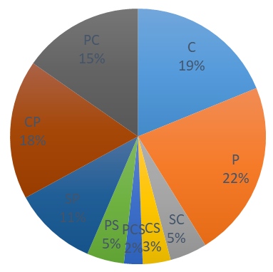
| Lithology | Average SBD (g cm-3) | Average %C | Average Carbon Stock (Mg C) | Average CO e (Mg CO ) 2 2 |
| Sandy Clay | 1.67 | 4.1 | 603.48 | 2214.77 |
| Clayey Sand | 1.49 | 2.8 | 326 | 1196.42 |
| Peaty Clayey Sand | 1.68 | 2.4 | 309.29 | 1135.09 |
| Peaty Sand | 1.47 | 3.7 | 164.85 | 605 |
| Sandy Peat | 1.3 | 8.6 | 226.56 | 831.48 |
| Clayey Peat | 1.23 | 14.9 | 614.48 | 2255.14 |
| Peaty Clay | 1.29 | 13.2 | 948.95 | 3482.65 |
cm= centimetre, g cm-3 =Gram per cubic centimetre, %C =organic carbon concentration, Mg C =Megagram carbon, Mg CO2 =Megagram Carbon dioxide equivalent, Table 2a: Variations of sediment bulk density (SBD), organic carbon concentration (%C) and Carbon Storage with Depth.
g cm-3 =Gram per cubic centimetre, %C =organic carbon concentration, Mg C =Megagram carbon, Mg CO2 =Megagram Carbon dioxide equivalent, Table 2b: Variations of sediment bulk density (SBD), organic carbon concentration (%C) and Carbon Storage with Lithology.
The values of SBD ranged from 0.95 g cm-3 to 1.97 g cm-3 with mean value of 1.30 g cm-3. The highest SBD value (1.97 g cm-3) was obtained in depth interval of 90-100 cm in location K2S2, while the lowest value (0.95 g cm-3) was obtained in depth interval of 5-10 cm in location K5S1. The mean SBD value is similar to 1.36 g cm-3 reported in Andoni flats by Ansa EJ [44]. This is consistent with the value of 1.4 reported by Eid EM [25]. However, SBD was highly affected by soil type. Sandy clay had the highest value while peat had the lowest value. Although SBD seemed to increase with depth, lithology is the main control as reported by Donato DC [24]. Variation of SBD across depth intervals of mangrove sediments can be attributed to the build-up of plant remains in the various layers of sediment [14]. SBD influences sediment’s porosity and compaction, thereby controlling the distribution of organic matter content [14].
The values of organic carbon concentration (%C) ranged from 0.9 % to 33.6 % with mean value of 12.48 %. The highest %C value (33.6 %) was obtained in depth interval of 60-70 cm in location K3S2 (peaty clay), while the lowest (0.9 %) was obtained in depth interval of 90-100 cm in K6S3 (peaty sand). The total average %C value was low in sand (12 %) but high in peaty clay (1,245 %) and clayey peat (1537 %) (Figure 2). Generally, %C decreases with depth (due to anthropogenic disturbances; Figure 3).
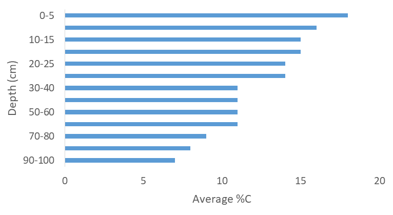
The highest %C in K3S2 could be attributed to depth, sediment type and SBD value. Variations of %C in mangrove ecosystem is dependent on forest composition and productivity, biomass, soil type, geographical and morphological settings, tidal range and anthropogenic effects [24, 45]. The variation of %C along depth intervals is consistent with the findings of [2, 14, 24, 25, 46, 47, 48]. It is clear that as depth increases, %C decreases due to variation in the ratio of organic matter obtained from the mangroves and allochthonous materials as well as from sources or organic carbon contained in sediments and organic material mineralization [26]. Also, decrease of %C with depth could result from decomposition, leaching, sediment regimes and biological cycling [17, 49]. The decrease of %C with depth in the study area could likely result from organic matter supply and its decomposition.
Carbon storage increases with depth (due to increase in SBD value and depth) and is consistent with the findings of [50]. (Table 2a and 2b; Figures 4). Carbon storage was highest in peaty clay (81,784 Mg C) and lowest in sand (970 Mg C) (Figure 5). The values ranged from 24.12 Mg C ha-1 in depth interval of 15-20 cm in location K1S3 (sandy peat) to 3,245.76 Mg C ha-1 in depth interval of 60-70 cm in location K3S2 (peaty clay) with mean value of 639.80 Mg C ha-1. The value is 1.49 times less than the global mean mangrove carbon storage of 956 Mg C ha-1[17]. The increase of carbon stock with depth could suggest the role of carbon cycling, decomposition and leaching enhanced by anthropogenic activities which are limited at higher depth [24, 50, 51]. Carbon dioxide equivalent (CO2e) ranged from 88.52 ± 15.18 Mg CO2 ha-1 to 11,911.94 ± 15.18 Mg CO2 ha-1 (mean = 2,348.07 ± 15.18 Mg CO2 ha-1)
![Figure 5: Variation of Total Carbon Storage with Depth in the Study Area. The sediment type played a significant role in the spatial distribution of %C and together with SBD, control the amount of carbon stock in the study area. Lithology varies along the sediment profile. The sediment type included peat, peaty clay, clayey peat, clay and sand. The total carbon stock of the study area was estimated at 947.78 ± 55.64 Gg C with total carbon dioxide equivalent (CO2e) of 3,478.36 ± 55.64 Gg CO2. The high value could be attributed to the mangrove cover of Niger Delta which is the largest in Africa [27,28,33].](/fulltextimages/9968/fig_5.png)
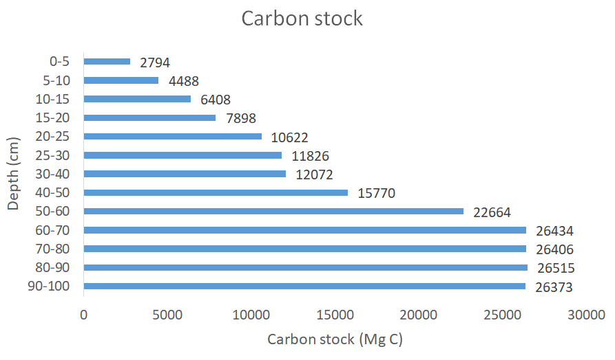
Figure 5: Variation of Total Carbon Storage with Depth in the Study Area. The sediment type played a significant role in the spatial distribution of %C and together with SBD, control the amount of carbon stock in the study area. Lithology varies along the sediment profile. The sediment type included peat, peaty clay, clayey peat, clay and sand. The total carbon stock of the study area was estimated at 947.78 ± 55.64 Gg C with total carbon dioxide equivalent (CO2e) of 3,478.36 ± 55.64 Gg CO2. The high value could be attributed to the mangrove cover of Niger Delta which is the largest in Africa [27, 28, 33].
Conclusion and Recommendation
This research has revealed the carbon storage mangrove sediments in Eastern Niger Delta, Nigeria. The values of SBD, %C and carbon storage significantly vary with soil type. Total carbon stock of study area was estimated at 947.78 ± 55.64 Gg C (equivalent to 3,478.36 ± 55.64 Gg CO2).
This implies that 3,478.36 ± 55.64 Gg of carbon dioxide could either be removed from the atmosphere by the mangrove forest of Niger Delta if sustainable forest management is pursued. This can help mitigate climate change and reduce its negative impacts. On the other hands, this same amount of carbon stored in sediments could be released back to the atmosphere if the current rate of deforestation and other forms of forest degradation in the study area remains unabated. This would exacerbate climate change impacts on both humans and the environment.
Therefore, the study recommends that the mangrove forest of Niger Delta region of Nigeria should be restored and protected against all anthropogenic-related degradation in order to preserve its carbon storage and ameliorate climate change issues. In addition, there is need for future research to determine the trend in carbon storage resulting from anthropogenic activities in the study area.
References
-
Shaltout KH, Ahmed MT, Alrumman SA, Ahmed DA, Eid EM (2019) Evaluation of the carbon sequestration capacity of arid mangroves along nutrient availability and salinity gradients along the Red Sea coastline of Saudi Arabia. Oceanologia 62(1): 56-69.
-
Eid EM, El Bebany AF, Alrumman SA (2016) Distribution of Soil Organic Carbon in the Mangrove Forests along the Southern Saudi Arabian Red Sea Coast. Rendiconti Lincei 27: 629-637.
-
Teme SC (2005) Effects of Domestic and Industrial Activities on Climate Change. Proceedings of Kyoto workshop of Rivers State Ministry of Environment on Minimizing Greenhouse Gas (GHG) Emissions in Rivers State. Port Harcourt Nigeria pp : 9-13.
-
Intergovernmental Panel on Climate Change IPCC (2007) The Fourth Assessment Report: Climate Change 2007.
-
Ibe AC (2017) Agricultural Practice in a Changing Climate: Beyond Infatuation to Devotion. A valedictory Lecture. University of Port Harcourt valedictory lecture series No 10.
-
Jiménez BEC, Oki NW, Arnell G, Benito JG, Cogley P, et al. (2014) In: Climate Change 2014: Impacts, Adaptation, and Vulnerability. Part A: Global and Sectoral Aspects. Intergovernmental Panel on Climate Change.
-
Peters EB, Wythers KR, Zhang S, Bradford JB, Reich B (2013) Potential climate change impacts on temperate forest ecosystem processes. National Research Council Canada Research Press 43(10): 939-950.
-
Robock A, Marquardt A, Kravitz B, Stenchikov G (2009) Benefits, Risks and Costs of Stratospheric Geoengineering. Geophysical Research Letters 36(19): 1-9.
-
Duarte CM, Middelburg JJ, Caraco N (2005) Major role of marine vegetation on the oceanic carbon cycle. Biogeosciences 2: 1-8.
-
Bouillon S, Borges A, Casteneda Moya E, Diele T, Dittmar T, et al. (2008) Mangrove production and carbon sinks: A revision of global budget estimates. Global Biogeochemistry Cycle 22(2): GB2013.
-
Ouyang X, Lee SY (2020) Improved estimates on global carbon stock and carbon pools in tidal wetlands. Nature Communications 317(2020).
-
Diesing M, Kroger S, Parker R, Jenkins C, Mason C, et al. (2017) Predicting the standing stock of organic carbon in surface sediments of the North-West European continental shelf. Biogeochemistry 135(2017): 183-200.
-
Diesing M, Thorsnes T, Bjarnadottir LR (2020) Organic carbon in surface sediments of the North Sea and Skagerrak. Biogeosciences 18(6): 2139-2160.
-
Eid EM, Arshad M, Khedher KM, Moatamed A, Ayed H, et al. (2019) Evaluation of carbon stock in the sediment of two mangrove species, Avicennia marina and Rhizophora mucronata, growing in the Farasan Islands, Saudi Arabia. Oceanologia 62(2): 200-213.
-
Kusumaningtas MA, Hutahaan AA, Fischer HW, Prez Mao M, Ransb D, et al. (2019) Variability in the organic carbon stocks, sources and accumulation rates of Indonesian Mangrove ecosystems. Estuarine Coastal and Shelf Science 218(2019): 310-323.
-
Stringer CE, Tretin CC, Zarnoch SJ (2015) Carbon Stock of Mangrove within the Zambezi River Delta Mozambique. Forests Ecology and Management 354: 139-148.
-
Alongi DM (2014) Carbon Cycling and Storage in Mangrove Forests. Annual Review of Marine Science, 6(2014): 195-219.
-
Kauffman JB, Donato DC (2012) Protocols for the Measurement, Monitoring and Reporting of Structure, Biomass and Carbon Stocks in Mangrove Forests. Center for International Forestry Research.
-
Paulsen HM (Eds.), (2020) Inventory of Techniques for Carbon Sequestration in Agricultural Soils. Thunen Institute of Organic Farming, North Sea Region.
-
Zhu Z, Bergamaschi B, Bernknop R, Clow D, Dye D, et al. (2010) A Method for Assessing Carbon Stocks, Carbon Sequestration and Greenhouse Gas Fluxes in Ecosystems of the United States under Present Conditions and Future Scenario. RestonVirginia: US Geological Survey.
-
Carraro C, Favero A, Massetti E (2012) Investments and Public Finance in a Green, Low Carbon, Economy. Energy Economics 34(1): 15-28.
-
Favero A, Mendelsohn R, Sohngen B, (2017) Using Forests for Climate Mitigation: Sequester Carbon or Produce Woody Biomass?. Climate Change 144(2): 195- 206.
-
Manyanda BN, Emmanuel F, Nzunda EF, Mugasha WA, Malimbwi RE (2020) Estimates of Volume and Carbon Stock Removals in Miombo Woodlands of Mainland Tanzania. International Journal of Forestry Research 2020: 4043965.
-
Donato DC, Kauffman JB, Murdiyarso D, Kurnianto S, Stidham M, et al. (2011) Mangroves among the most carbon-rich forests in the tropics. Nature Geoscience 14(201): 293-297.
-
Eid EM, Shaltout KH (2016) Distribution of soil organic carbon in the mangrove Avicennia marina (Forssk.) Vierh. along the Egyptian Red Sea Coast. Regional Studies in Marine Science 3(2016): 76-82.
-
Malunguja GK, Devi A, Kilonzo M, Rubanza CDK (2020) Climate change mitigation through carbon dioxide (CO2) sequestration in community reserved forests of northwest Tanzania. Archives of Agriculture and Environmental Science 5(3): 231-240
-
Onwugbuta Enyi J, Zabbey N, Erondu E (2008) Water quality of Bodo Creek in the lower Niger Delta basin. Advances in Environmental Biology 2(3): 132-136.
-
Essen C, Abuja (2020) Government Plans Niger Delta Mangrove Restoration Project. The Guardian.
-
Rome (2007) The World’s Mangroves 1980-2005. Food and Agriculture Organization of the United Nations pp: 153.
-
Giri C, Ochieng E, Tieszen LL, Zhu Z, Singh A, et al. (2011) Status and distribution of mangrove forests of the world using earth observation satellite data. Global Ecology and Biogeography 20: 154-159.
-
Van der Werf GR, Morton DC, Defries RS, Olivier JGJ, Kasibhatla PS, et al. (2009) Carbon dioxide (CO2) Emissions from Forest Loss. Nature Geoscience 2: 737- 738.
-
Nwobi C, Williams M, Mitchard ET (2020) Rapid mangrove forest loss and Nipa Palm (Nypa frutica) expansion in the Niger Delta, 2007-2017. Remote sensing 12(4): 2344.
-
Numbere AO (2018) Mangrove species Distribution and Composition, Adaptive Strategies and Ecosystem Services in the Niger Delta, Nigeria. Mangrove Ecosystem Ecology and Function.
-
Asuk SA, Offiong EE, Ifebueme NM, Akpaso EO (2018) Species composition and diversity of mangrove swamp forest in southern Nigeria. International journal of Avian and Wildlife Biology 3(2): 159-164.
-
Evamy BD, Harembourne J, Kamerling WA, Knapp WA, Molloy FA, et al. (1978) Hydrocarbon habitat of Tertiary Niger Delta. Bulletin of American Association of Petroleum Geology 62(1): 1-39.
-
Short K, Stauble A (1967) Outline of Geology of Niger Delta. AAPG Bulletin 51(5): 761-779.
-
Avbovbo AA (1980) Basement geology in the sedimentary basins of Nigeria. Geology 8: 323-327.
-
Obaje NG (2009) Geology and Mineral Resources of Nigeria. 1st (Edn.), Springer, New York, pp: 221.
-
(1990) British Standard methods of test for soils for civil engineering purposes. British Standard Institution London.
-
(2000) ASTM D 2974-87 Standard Methods for Moisture, Ash and Organic Matter of Peat and other Organic Soils. American Society of Testing and Materials.
-
Iticha B (2017) Ecosystem Carbon Storage and Partitioning in Chato Afromon-tane Forest: Its Climate Change Mitigation and Economic Potential. International Journal of Environment Agriculture and Biotechnology 2(4): 1785-1794.
-
Allen CD, Macalady AK, Chenchouni H, Bachelet D, McDowell N, et al. (2010) A global overview of drought and heat-induced tree mortality reveals emerging climate change risks for forests. Forest Ecology and Management 259(4): 660-684.
-
Siraj M (2019) Forest carbon stocks in woody plants of Chilimo-Gaji Forest, Ethiopia: Implications of managing forests for climate change mitigation. South African Journal of Botany 127: 213-219.
-
Ansa EJ, Francis A (2007) Sediment Characteristics of the Andoni Flats, Niger Delta, Nigeria. Journal of Applied Science and Environmental Management 11(3): 21-25.
-
Gao Y, Zhou J, Wang L, Guo J, Feng J, et al. (2019) Distribution patterns and controlling factors for the soil organic carbon in four mangrove forests of China. Global Ecology and Conservation 17(2019): e00575.
-
Schile LM, Kauffman JB, Crooks S, Fourqurean JW, Glavan J, et al. (2017) Limits on Carbon Sequestration in Arid Blue Carbon Ecosystems. Ecological Applications 27(3): 859-874
-
Almahasheer H, Serrano O, Duarte CM, Arias Ortiz A, Masque P, et al. (2017) Low Carbon sink capacity of Red Sea mangroves. Scientific Reports 7(2017): 9700.
-
Adame ME, Kauffman JB, Medina I, et al. (2013) Carbon stocks of tropical coastal wetlands within the karstic landscape of the Mexican Caribbean. PLoS ONE 8(2): e56569.
-
Sanderman J, Heng T, Fiske G, Solvik K, Adame M, et al. (2018) A global map of mangrove forest soil carbon at 30 m spatial resolution. Environmental Resources Letter 13(5) : 12.
-
Shaltout KH, Ahmed MT, Alrumman SA, Ahmed DA, Eid EM (2020) Evaluation of the carbon sequestration capacity of arid mangroves along nutrient availability and salinity gradients along the Red Sea coastline of Saudi Arabia. Oceanologia 62(1): 56-69.
-
Arshad M, Alrumman S, Eid EM (2018) Evaluation of carbon sequestration in the sediment of polluted and non-polluted locations of mangroves. Fundamental Applied Limnology 192(1): 53-64.
- Lessons to Learn: Trees are More than the Lungs of the World
- Community Forestry Enterprises as a Model for Sustainable Forest Development: The Case Of The "Baja Tarahumara" in Chihuahua, Mexico
- Ecological and Socio-Economic Impacts of Chromolaena odorata and Mesosphaerum suaveolens, Two Invasive Alien Species in Central and Southern Benin, West Africa
- Epigenetic Sustainability: Modeling the Human Factor as a Natural Resource through Science 4.0 and the NR3C1 Biological Pilot
- Growth-at-Risk: A Framework for Assessing Economic Vulnerability
- The Rural Territory as a Socioecological System for the Management of Public Policy for Sustainable Rural Development