Dynamics of Land Use Land Cover Change and Soil Erosion Rate in Chure Landscape of Sudurpaschim Province
Land use land cover, a dynamic process, has become a central component of current strategies in managing natural resources and monitoring environmental changes. This study adopts an integrated GIS and Remote Sensing approach to assess changes in land use, land cover (LU/LC), and soil erosion rates between 2001 and 2021. Land use maps were generated using supervised classification and the Maximum Likelihood algorithm, while RUSEL factors facilitated soil erosion mapping analysis. The findings underscore a remarkable decrease in 'agricultural land' and 'water,' accompanied by a simultaneous increase in 'settlement area,' 'forest area,' and 'bare land.' Agricultural land witnessed an annual decline of 2.5 percent, while water bodies decreased by 0.65 percent in 2021. Forest areas exhibited a 0.09 percent increment from 2001 to 2021, and settlement areas expanded at a rate of 0.41 percent annually. Notably, agricultural land reduction primarily contributed to the growth of settlement areas. Additionally, soil erosion rates rose from 3.82 (t/ha/year) in 2001 to 4.090 (t/ha/year) in 2021, indicating a correlation between land use change and soil erosion. Factors such as increased settlement, population growth, infrastructure development, riverbank cutting, and erosion were associated with the decline in agricultural land. Effective land use planning in the Churia region is imperative to address these changes. Government intervention and stakeholder cooperation are crucial to curbing forest degradation, unchecked human settlement expansion, and riverbank cutting. Furthermore, the study advocates for the intensified use of GIS and Remote Sensing technologies in monitoring and managing natural resources.
Introduction
Land is an essential natural resource in the world for the preservation of terrestrial ecosystems and the subsistence of humanity. Land is a crucial natural resource both in the developed and developing world. The livelihood of developing countries is directly linked to land resources, as agriculture is the primary economic activity for the overwhelming population [1].
Land use land cover (LU/LC) is the combined land use and land cover of the earth resources. Land use implies the people consumed the land resources, whereas land cover includes forest or water body. Hence, LU/LC is the earth environmental balance [2]. Land degradation is the product of many processes such as changes in land-use and global climate [3]. Changes in the land-use patterns due to deforestation, in relationship with the population growth, accelerate fertile land degradation processes [4].
Soil erosion is the output of the land use land cover change [5]. Soil erosion has become a global environmental disaster [6]. It causes extreme environmental troubles, inclusive of the loss of plant nutrients and other chemicals. Assessing soil erosion became particularly important in the last few years, and a serious interest has been paid to connect its rate to land use land cover change. Additionally, global climate change, intensification of agriculture, changing patterns of agricultural practices, and land degradation trigger soil erosion [7].
Nepal is divided into five physiographic regions, High Himalayan, High Mountain, Middle Mountation, Siwaliks, Churia, and terai (LRMP, 1986). Churia is a belt of hilly region stretching from East to West in the entire length of the southern part of Nepal. This region is ecologically diverse and provides several ecosystem services to the downstream area, directly influencing the environment’s quality. Since this area is the youngest Mountain range in the Himalayas and has a high potential for erosion hazard.
The Churia Hills, structurally weak and the youngest Himalayan range, face high erosion hazards from forest degradation and agriculture. Swift land use changes pose severe environmental threats, necessitating urgent assessment between 2001 and 2021. Multiple activities like migration, deforestation, and urbanization drive these changes, impacting the hills’ fragile nature. Due to the combined effect of these anthropogenic activities and climate change, future is going to be more devasting [8]. Strategic plans are vital to safeguard against debris flows, landslides, and soil erosion, given the region’s susceptibility to environmental challenges.
This study is specially designed to explain the changes in the magnitude of various land use, the behavior of transformation between land use and the severely transformed areas and degraded areas and soil erosion rate of the area within the Churia landscape of Sudurpachhim Pradesh. The quantitative assessment of land transformation and land degradation (soil erosion) becomes essential, which may be accomplished through several approaches using detailed and spatially distributed information.
The Multiple development activities like migration, deforestation, infrastructure development, urbanization, and so on are the main reason for land use land cover change in Churia region of Nepal [9]. The Churia hills are the most recent mountain system of the Himalayan orogeny and the slopes are dry with poor slope development [10]. Churia hills characterize the steep and dissected topography, which is underlain by highly deformed and complicated structures of sedimentary rocks [11].
Therefore, we wish to assess the dynamic of land use land cover change and soil erosion rate between 2001 to 2021. The impact of land cover change is likely more significant than climate change since it changes all the biophysical components of ecosystems [12]. Continuously studying and monitoring LU/LC changes and soil erosion rate are particularly important in understanding the dynamics and predicting the patterns and trend of changes in a natural landscape and associated ecosystems at local, regional, and global scales, and to provide evidence-based support to improve land management policies and practices [13].
There are various methods that can be used in the collection, analysis, and presentation of resource data, but the use of Geographic information system (GIS) and Remote Sensing (RS) technologies can greatly facilitate the process [14]. GIS and Remote Sensing are now providing an efficient tool for advanced ecosystem management. The collection of remotely sensed data facilitates the synoptic analyses of earth-system function, patterning, and change at local, regional, and global scales over time. Such data provides an important link between intensive, localized ecological research and regional, national and international conservation and management of biological diversity [15].
Therefore, the mapping of LU/LC and assessing soil erosion rate will be beneficial to predict possible changes that may take place in the near future by GIS and remote sensing. However, limited studies are carried out on mapping of LU/LC outside the protected areas especially in developing countries like Nepal. The study of LU/LC and soil erosion rate provides information about the status of natural resources and helps in monitoring, modeling, and environment change detection [10]. In Nepal, Satellite remote sensing data have been used for the past two decades in specific areas and its importance is still increasing [16]. Change information about the Earth’s surface is becoming more and more important in the monitoring of the local, regional, and global environment.
Materials and Methods
Study Area
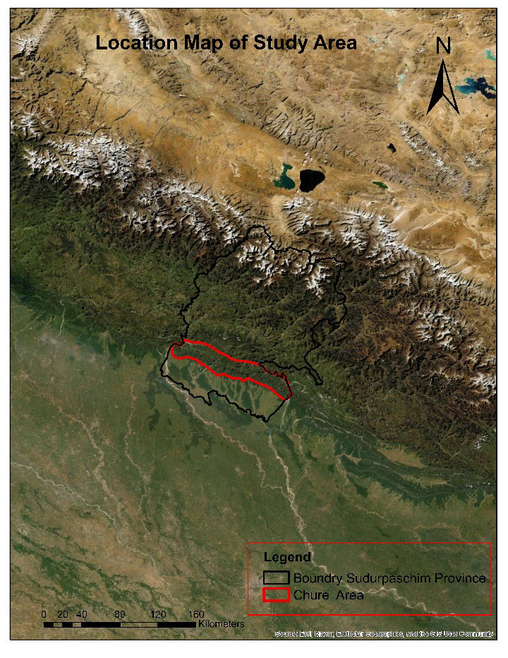
The Study area (Figure 1) lies in Sudurpaschim Province. It is located between 28.220 to 30.090 North latitude and 80.030 to 81.250 East longitude. It has an area of about 210,537.40 ha, which is about 11 % of the whole area of the Churia range of Nepal. It shares the boundary with the Inner Terai region in the south and northern boundary with the middle mountain region. It has 8% population of the whole chure region.
In terms of climate, the study area experiences distinct seasons of winter, spring, and monsoon with a tropical climate, featuring an average annual temperature of 30.5°C. Summer temperatures can peak at 44.5°C, while winter temperatures can drop to 2.5°C. The region receives maximum rainfall from mid-June to mid-September, with the highest intensity occurring from mid-June to mid-July. The average annual rainfall is approximately 1702 mm [17].
Biodiversity in the Churia range of Sudurpaschim
Pradesh encompasses tropical and sub-tropical forests. The flora is characterized by dominant Sal (Shorea robusta) forests and tropical mixed hardwood (TMH) forests, with Hill Sal and Chir-pine (Pinus roxburgii) forests prevalent in the northern part. Other forest types found in the study area include riverine forests (Dalbergia sissoo, Acacia catechu) along the rivers. The majority of the region’s forests are located within the Churia range.
Research Design
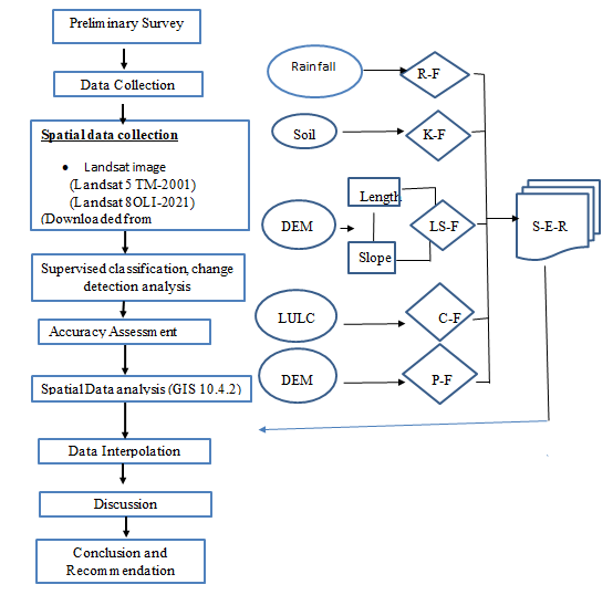
Data Collection
Primary data collection For Spatial analysis Basically, data were collected in two ways:
- Two temporal Landsat images were downloaded from the www.glovis.usgs.gov
- Data for training and validation samples of land cover classification were collected from the field using GPS.
| Satellite image | Sensor | Numbers of bands | Spatial resolution | Data of Acquired | Cloud cover (%) | |
|---|---|---|---|---|---|---|
| 1 | Landsat 5 | TM | 1-7 | 30 m | 2001-04-30 | 5 |
| 2 | Landsat 8 | OLI/TIR | 1-11 | 30 m | 2021-04-16 | 5 |
Table 1: Landsat image used for land use/land cover classification.
| Dataset | Data Source |
| DEM* | ASTER GDEM† version 2 (30 m) |
| DEM* | www.jspacesystems.or.jp/ersdac/GDEM/E/4.html |
| DEM* | A product of METI and NASA |
| Soil Map | Digital Soil Map of the World (2007) |
| Soil Map | www.fao.org/geonetwork/srv/en/metadata |
| Soil Map | Produced by FAO-UNESCO and (1:5,000,000 scale) |
| Land cover map | Land sate Image (www.glovis.usgs.gov) |
| Rainfall map | Map Mean Annual Precipitation of Nepal Produced by DHM |
Table 2: Soil Erosion data.
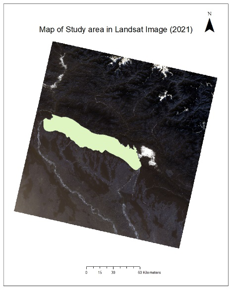
Satellite images These Landsat satellite images were Landsat Thematic Mapper (TM) and Landsat-8 (OLI) Landsat 8 OLI (2021-04-16)
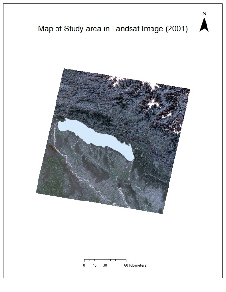
Landsat TM (2001-04-30)
Secondary Data collection
Secondary data and information were collected through Literature review. Collection and analysis of Secondary Data were done from Divisional forest office (DFO), Department of Metrology and Hydrology (DMH), Chure office, Topo sheets from department of survey, journals, magazines, etc. Various websites and documents through the internet were also studied during secondary data collection and literature review.
Software’s and equipment’s used in the study
| Functions | |
|---|---|
| ArcGIS 10.4.2 | Preparation of thematic map, Image classification, accuracy assessment |
| ERDAS-Imagine | Layer stack, Image sub-setting |
| Google Earth | Field verification |
| MS- Office package | Database comparison, Manifestation in Bar-diagram, Area computation |
| GPS | Tracking GPS co-ordinates for training samples |
Table 3: Software’s and equipment’s used in the study area.
Methods
Satellite Image processing
Two satellite images with minimal cloud cover were carefully chosen from the available dataset to analyze Land Use Land Cover changes between 2001 and 2021. Both images were projected into UTM Zone 44 using the WGS 1994 datum. Radiometric correction was not applied as all images were captured during the same season, albeit in different months. The Area of Interest (AOI) was delineated using the subset tool in ERDAS IMAGINE. Image enhancement, a standard practice to improve the visibility and interpretability of an image, involves techniques such as edge enhancement and resolution merging to enhance the apparent distinction between features in the scene.
Field Sampling Design
Training samples were collected with the help of GPS during field visit for land interpretations for the satellite image 2021. The GPS point of the training sample collection was carried out by Stratified random sampling technique and was proportional to each land use/land cover class area.
Land use land cover (LU/LC) classification Supervised classification was performed to classify the image into different land use change. The maximum likelihood classifier [18] was used in the supervised classification [19]. In this, an unknown pixel ‘x’ with multispectral value (n, ‘bands’) will be classified into class K that has the maximum likelihood. The likelihood (Lk) is defined as the posterior probability of a pixel belonging to class K (Japan Association of Remote Sensing). Data on the different land use and land cover obtained from the field survey (GPS location) was used as training samples for supervised classification. Land use land Cover are classified in following 5 classes:
- Forest
- Water Bodies
- Agriculture/ Cultivated land
- Bare Land
- Settlement/ Built Up Area
| Recorded land use/ land cover | Land use/ land cover in the field |
| Forest | An area covered with natural forest |
| Water Bodies | An area covered with rivers, lakes etc. |
| Settlement/Built Up Area | The area covered by settlements, infrastructure, road side etc. |
| Agriculture/Cultivated land | An area covered with agricultural land, grasses, shrubs and others |
| Bare land/Sandy land | An area covered with barren land, sandy area river bank |
Table 4: Description of land use/ land cover classes.
- Training samples were categorized respectively to the Land classes.
- A signature file was created with the help of a training sample using GIS 10.4.2
- Supervised classification was performed on both images feeding their respective signature life Accuracy assessment of the classified images was done by calculating producer accuracy, user accuracy, overall accuracy, and overall kappa coefficient in ArcGIS 10.4.2.
Change detection and analysis
The classified images prepared in ArcGIS 10.4.2 of two different dates were processed through a raster calculator to produce LU/LC change maps showing “From to” change in land use/ land cover between 2001 and 2021. The numerical analysis of land use dynamics was then done through Microsoft Excel.
The following formula was used to estimate the rate of land use/land cover change: Rate of change (%) = (UNDP, RFDTh and FAO Where, a1= base year data (e.g. 1995 LULC data for different classes) a2= end year data (e.g. 2018 LULC data for different classes) n= no. of years (i.e 23years) Rainfall and runoff factor (R) The rainfall erosivity aspect describes the variety of rainfall erosion index units that are measured through the erosive energy of rain expressed in tons meter per hectare hour or joule per square meter. It was calculated using a dataset of 20 years from different stations. In this study, the rainfall map produced by the International Center for integrated Mountain Development (ICIMOD) was used to generate a rainfall erosivity factor. The rainfall map represents the country’s mean annual precipitation, produced from the ground meteorological station. The equation integrated to generate the R-factor is given by Morgan [20]. R= 38.5+0.35P, R= Rainfall Erosivity, P= mean annual rainfaal in mm Soil erodibility factor (K) Soil erodibility is standard erosion in ton per hectare per unit of erosivity R, for a specific soil, is a quantity of the inherent susceptibility of soil particles to erosion; The k values are predicted using information about soil properties, which consist of soil texture, content of organic matter, soil structure and permeability [21]. An arithmetical approximation [22] of the nomograph was used to estimate the soil erodibility factor (K): K= [2.1*10-4 *(12-OM)*M1.14+3.25*(S-2)+2.5*(P-3)]/100 Topographic factor (LS) LS is the slope length factor, which expresses the soil loss ratio of a slope with a given length and the soil loss of a slope with a standard length of 22.13 m, with the same erodibility and slope gradient values. S is the slope steepness factor, which is a ratio of soil loss from the sector slope gradient to that from a 9% slope underneath otherwise same situation; define the slope effect of the gradient slope on soil loss in step with a unit region. An extensively used method for calculating LS derived from [23] equation is presented as follows: LS=(As/22.1)0.4* (sinb/0.09)1.4 Where As represents the accumulated flow of the unit’s stream, b is the slope in degree.
Cover Management Factor (C)
The cover-management factor (C) is used to reflect the effect of cropping and other management practices on erosion rates. Vegetation cover is the second most important factor next to topography that controls soil erosion risk. The land cover intercepts rainfall, increases infiltration, and reduces rainfall energy. In areas where land uses other than cropping dominate, as in the Himalaya, the C factor is normally assigned based on a simple assessment of vegetation cover, rather than close analysis of agricultural cropping patterns. In this study, Land Use/Land Cover (LU/ LC) was used for preparing a C-factor map. First, the raster map was converted to polygon and the attributes with same land use type were merged in ArcGIS. From this, eight types of land use were obtained For each land use type, C values were assigned through reference [24]. The C factor ranges from 0 to approximately 1, where higher values indicate no cover effect and soil loss comparable to that from a tilled bare fallow, while lower C means a very strong cover effect resulting in no erosion [25].
| C-factor | |
|---|---|
| Forest | 0.03 |
| Shrub land | 0.03 |
| Grass land | 0.01 |
| Agriculture land | 0.21 |
| Barren land | 0.45 |
| Water Body | 0.0 |
| Settlement/ Built up area | 0.0 |
Table 6: Cover Management Factor [24].
Conservation Practices Factor (P)
Support Practice Factor (P) indicates the rate of soil loss according to the various cultivated lands. Contours, cropping, and terrace methods are important factors that can control erosion [26]. The P values range from 0 to 1, where 0 represents a very good anthropic erosion resistance facility, and 1 indicates a non-anthropic resistance erosion facility. In Nepal, farming practices in sloppy agricultural land occur through the construction of terraces that closely resemble contour farmland, which is a means of conservation farming. Thus, we consider the contour farmland as an agricultural support practice.
| Slope % | Contouring |
|---|---|
| 0-7 | 0.55 |
| 7-11.3 | 0.60 |
| 11.3-17.6 | 0.80 |
| 17.6-26.8 | 0.95 |
| >26.8 | 1 |
Table 5: P factor values for slope as per agricultural practice [26].
Results and Discussion
Result
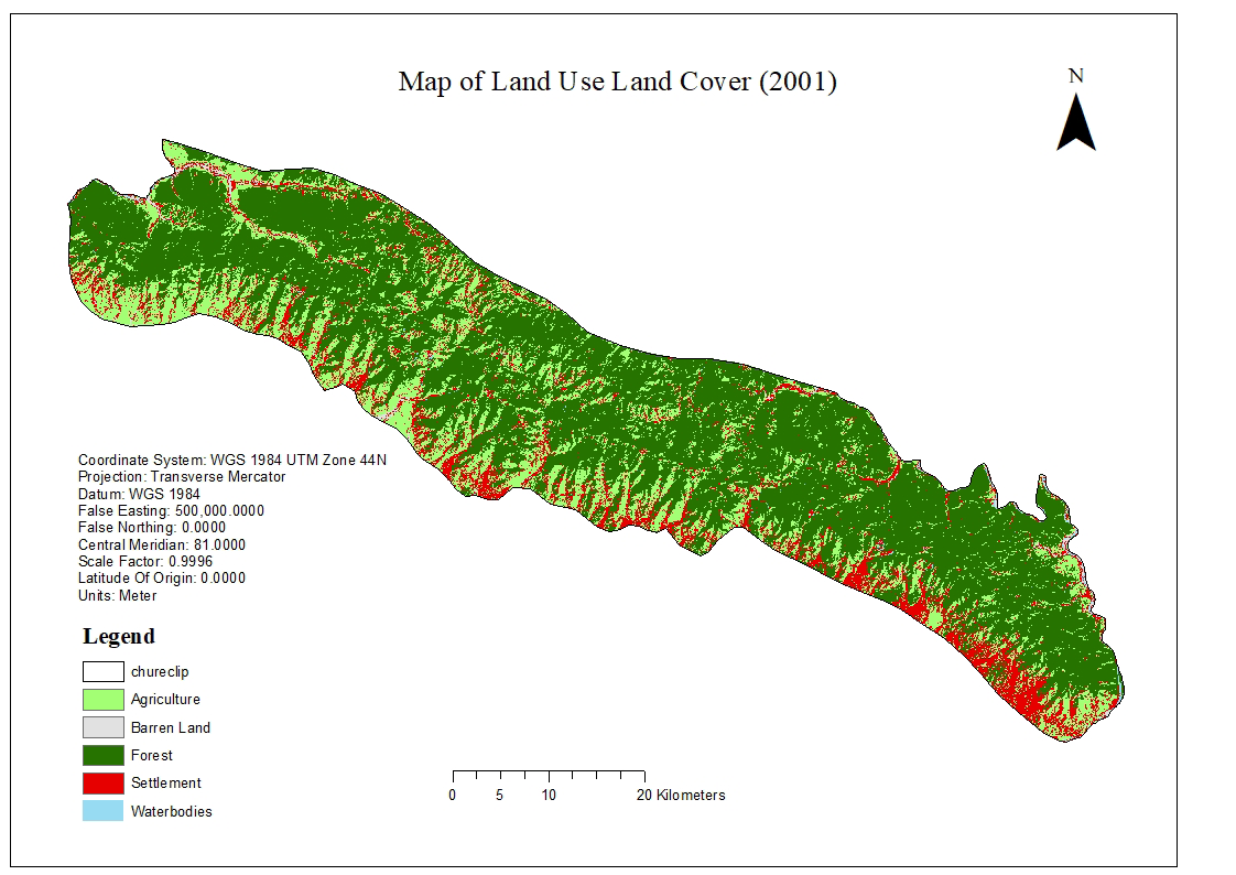
Land use Land cover in 2001
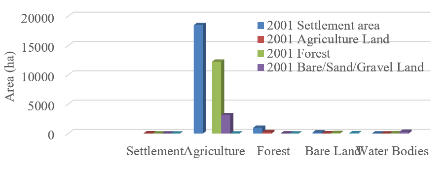
Five Land use land cover classes were classified in this period. The land use patterns included forest, cultivated land, settlement area, bare land and water bodies (Figure 5). Forest land covered 136409.39 ha which was 65.11 % of the total area. Agriculture land covered 47625.82 ha which was 22.73 % of the total area. Built up area covered 23424.58 ha which was 11.18% of the total area. Bare land covered 1271.44 ha which was 0.61% of the total area. Water bodies covered 782.68 ha which was 0.37 % of the total area (Table 7).
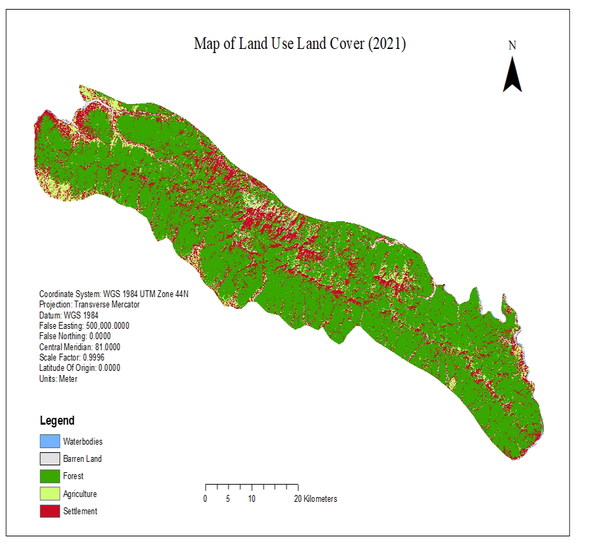
Land use Land cover in 2021
area. Agriculture land covered 14075.89 ha which is 6.72% of total area. Settlement area covered 39913.60 ha which is 19.05% of the total area. Bare land covered 5851.27 ha which is 2.79 % of total area. Water bodies covered 474.06 ha which is 0.23 % of total area (Table 7).
Similarly, five land use land cover classes were classified in this period. The use patterns include forest, agriculture land, settlement area, bare land and water bodies (Figure 6). Forest land covered 149203.34 ha which is 71% of the total
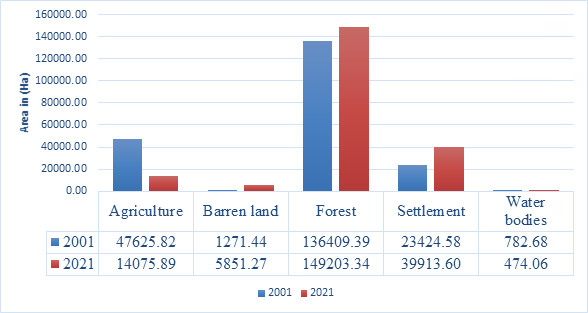
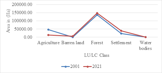
Land use land cover change in 2001 and 2021
The land use and land cover change in 2001 and 2021 was compared in Table 7. There was a fluctuation between total areas of different land use and land cover classes between 2001 and 2021. Forest area was increased by
6.1%; agriculture land was decreased by 16.01 %, whereas bare land increased by 2.79 %, settlement area increased by 7.87%, and water bodies decreased by 0.14 % by 2021. Table 8 shows the alteration in the major land use and land cover types within the Churia range of Sudurpaschim Pradesh.
| Land use Land cover types | 2001 | 2021 | Change | |||
|---|---|---|---|---|---|---|
| Area (ha) | % cover | Area (ha) | % cover | Area (ha) | % cover | |
| Forest | 136409.4 | 65.11 | 149203.3 | 71.21 | 12,793.95 | 6.1 |
| Agriculture land | 47625.82 | 22.73 | 14075.89 | 6.72 | -33549.9 | -16.01 |
| Settlement Area | 23424.58 | 11.18 | 39913.6 | 19.05 | 16,489.02 | 7.87 |
| Bare land | 1271.44 | 0.61 | 5851.27 | 2.79 | 4,579.44 | 2.18 |
| Water | 782.68 | 0.37 | 474.06 | 0.23 | -308.62 | -0.14 |
| Total | 138200 | 100 | 209518 | 100 |
Table 7: Status of Land use Land cover in 2001 and 2021.
| Land use Land cover types | 2001 | 2021 | ||
|---|---|---|---|---|
| Area (ha) | % cover | Area (ha) | % cover | |
| Forest | 136409.39 | 65.11 | 149203.34 | 71.21 |
| Agriculture land | 47625.82 | 22.73 | 14075.89 | 6.72 |
| Settlement area | 23424.58 | 11.18 | 39913.60 | 19.05 |
| Bare land | 1271.44 | 0.61 | 5851.27 | 2.79 |
| Water | 782.68 | 0.37 | 474.06 | 0.23 |
| Total | 209513.90 | 100 | 209518.16 | 100 |
Table 8: Land use land cover change in 2001 and 2021.
Area comparison of LU/LC in 2001 and 2021
Trend analysis of LU/LC Change in 2001 and 2001
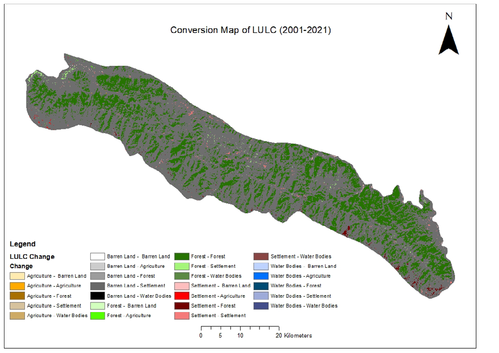
The research reveals that a considerable amount of forest, i.e. 1247.04 ha of forest was converted into other Land use land cover classes during the period of 2001-2021. However, 12392.42 ha of other Land use land cover classes transformed into forest, it shows a slight increase in the forest area. Similarly huge amount of agriculture land, i.e. 21583.33 ha was converted to other classes while 301.51 ha of land classes converted to agriculture land. In the same way 19702, 15 ha of other land cover classes converted to settlement area while 52.58 ha of built up area was transformed into other land classes and 4461.95 ha of other land classes converted to bare/sandy land while 370.46 ha of bare/sandy land converted to other land classes and 67.57 ha land classes to water while 351.1 ha of water converted to other land classes. Finally, resulting and decreased of 33549.93 ha of agriculture land, and increment of 12793.95 ha of forest area and 16489.02 ha of settlement/built up area. Decrease of 308.62 ha of water with an increment of 4579.59 ha of bare/sandy land.
The research also shows that largest transformation between classes was conversion of 18491.68 ha of agriculture land to settlement area followed by conversion of 12250.54 ha of agriculture land to forest area. However, the smallest transformation was the conversion of 2.33 ha of settlement area to water. Likewise, small area of agriculture land to water bodies. Conversion of agriculture land to settlement area and forest area indicates the possibility of developmental activities by people and keeping the cultivable land bare with out farming . The map shows the major conversion of agriculture land to bare/sandy land along the river bank region due to the flooding and river bank cutting.
| 2001 | Land use Land cover Classes | 2021 | |||||
|---|---|---|---|---|---|---|---|
| Settlement area | Agriculture Land | Forest | Bare/Sandy Land | Water Bodies | Grand Total (2001) | ||
| Settlement/Built up Area | 23101.21 | 25.36 | 12.36 | 11.54 | 2.32 | 23424.58 | |
| Agriculture/ Cultivated Land | 18491.68 | 13890.71 | 12250.54 | 3137.22 | 3.89 | 47625.82 | |
| Forest | 987.36 | 234.61 | 127106.91 | 14.98 | 10.45 | 136409.39 | |
| Bare Land | 189.22 | 38.32 | 92.02 | 1198.44 | 50.9 | 1271.44 | |
| Water Bodies | 12.11 | 3.22 | 37.56 | 298.21 | 391.68 | 782.68 | |
| Grand Total (2021) | 39913.6 | 14075.89 | 149203.34 | 5851.27 | 474.06 | 209513.91 |
Table 9: Land use Land cover transformation from 2001 to 2021.
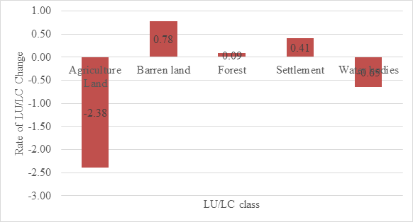
Rate of Land use Land cover change
| Land use Land cover classes | Rate of Changes (%) | |
|---|---|---|
| 1 | Forest | 0.09 |
| 2 | Agriculture/Cultivated land | -2.38 |
| 3 | Settlement/Built up Area | 0.41 |
| 4 | Bare Land | 0.78 |
| 5 | Water bodies | -0.65 |
Table 10: Rate of land use land cover change between 2001 and 2021.
The above table shows that the cultivated land has the highest rate of change or fluctuation in the area, i.e. -2.38 %, followed by bare land (0.78 %), water bodies (-0.65 %), built- up area (0.41 %), and forest (0.09 %)respectively. We can conclude from this result that the forest is increasing by 0.09 % every year and if this rate of forest restoration happens in the near future than the condition of chure will be improve. On other hand the rate of built-up area development is increasing more rapidly than forest restoration and agriculture land is decreasing rapidly so If the trend of built up area expansion remains same the open space are the cultivated land that is remaining in the churia region of Sudurpaschim Pradesh will be covered by built-up area in the near future.
| Accuracy for 2001 | Accuracy for 2021 | |||
|---|---|---|---|---|
| LU/LC class | User’s Accuracy | Producer’s Accuracy | User’s Accuracy | Producer’s Accuracy |
| Forest | 93.65 | 89.39 | 91.55 | 90.28 |
| Cultivated land | 78.33 | 82.46 | 83.10 | 86.76 |
| Built up Area | 68.29 | 75.68 | 78.72 | 80.43 |
| Sand/Gravel | 80.64 | 83.33 | 86.84 | 84.62 |
| Water | 94.12 | 72.73 | 92.0 | 85.19 |
| Overall accuracy= 82.5% Kappa statistics = 0.7729 | Overall accuracy= 86.11 Kappa statistic= 0.8209 |
Table 11: Accuracy assessment for classified image of 2001 and 2021.
Soil Erosion Map 2001
The input data were processed in ArcGIS and five factor maps: R, K, LS, C, and P, were produced (Figure 12). These raster maps were integrated within the ArcGIS environment using the RUSLE relation to generate composite maps of the estimated erosion loss within the study area. Using a zonal statistics tool, computed an area-weighted mean of the potential erosion rates for region. Similarly, the erosion rates for slopes and LU/LC were generated to explore the relationship between slope and LU/LC on erosion. First, the slope map of region was generated from DEM in ArcGIS and then reclassified into 5 classes. The erosion values for each class were thus obtained using zonal statistics. The mean erosion rate of the region was 3.82 ( t/ha/year).
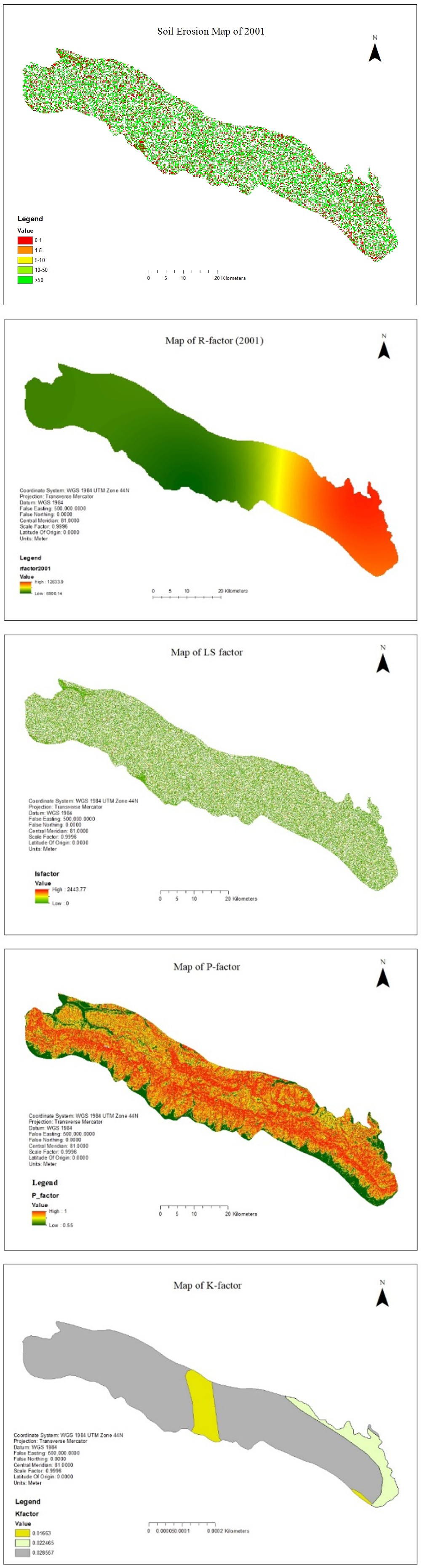
Factor Maps for RUSEL (2001)
The results showed that the Rainfall Erosivity Factor (R) value ranges between 12633.9 and 6900.16 MJ mm ha−1 h−1
yr−1, with the highest values being in the eastern part of the region and the lower values in the western part of the region (Figure 13a).
Figure (13a): Map of R-factor for 2001. Figure (13b): Map of LS-factor for 2001.
Figure (13c): Map of K-factor for 2001. Figure (13d): Map of P-factor for 2001.
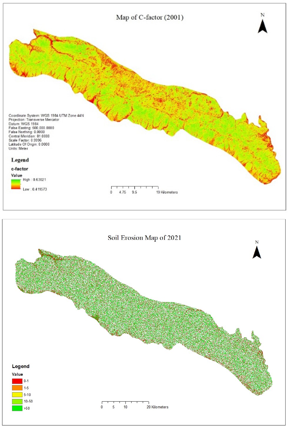
Figure (13e): Map of C-factor for 2001. The topographic Factor (LS) value for the entire area ranged from 0 to 24.24 (Figure 13b). Soil Erodibility Factor (K) value ranged from 0.016 to 0.028 (Figure 13c).The Cover Management Factor (C) value ranged between 0 and 0.63. The value indicates the percentage erosive capacity in comparison with the bare fallow area. The highest value of 0.63 indicates that 45% of erosion occurs in the area compared to the bare fallow land (Figure 13e). The Support Practice Factor (P) value ranged from 0.55 to 1, where a higher value indicates there is no support practice such that erosion is at its maximum due to the absence of any practice.
Soil Erosion Map of 2021
The input data were processed in ArcGIS and five-factor maps: R, K, LS, C, and P, were produced (Figure 14). These raster maps were integrated within the ArcGIS environment using the RUSLE relation to generate composite maps of the estimated erosion loss within the study area. Using a zonal statistics tool, computed an area-weighted mean of the potential erosion rates for region. Similarly, the erosion rates for slopes and LU/LC were generated to explore the relationship between slope and LU/LC on erosion. First, the slope map of region was generated from DEM in ArcGIS and then reclassified into 5 classes. The erosion values for each class were thus obtained using zonal statistics. The mean soil erosion rate is 4.09 (t/ha/year).
Factor Maps for RUSEL (2021)
The results showed that the Rainfall Erosivity Factor (R) value ranges between 13123.8 and 7595.61 MJ mm ha−1 h−1 yr−1 with the highest values being in the eastern part of the region and the lower values in the western part of the region (Figure 15a). The topographic Factor (LS) value for the entire area ranged from 0 to 24.24 (Figure 15b). Soil Erodibility Factor (K) value ranged from 0.016 to 0.028
(Figure 15c). The value of the Cover Management Factor (C) ranged between 0 and 0.55. The value indicates the percentage erosive capacity in comparison with bare fallow area. The highest value of 0.63 indicates that 45% of erosion occurs in the area in comparison with the bare fallow land
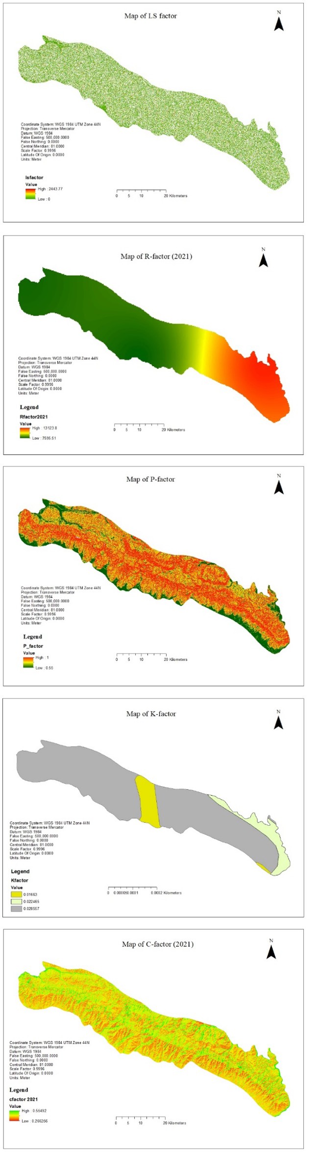
(Figure 15d). The Support Practice Factor (P) value ranged from 0.65 to 1 where a higher value indicates there is no any support practice such that erosion is at its maximum due to the absence of any practice.
Figure (15a): Map of R-factor for 2021. Figure (15b): Map of LS-factor for 2021.
Figure (15c): Map of K-factor for 2021. Figure (15d): Map of P-factor for 2021.
Figure (15e): Map of C-factor for 2021.
Discussion
The primary aim of this study was to forecast Land Use Land Cover changes and soil erosion rates over the past two decades. In the period from 1995 to 2010, a decrease in forest cover was observed in 27 districts, as reported in the Churia Assessment report [27]. Notably, Kanchanpur district exhibited a positive increment, while Kailali showed a negative increment in forest cover within the Chure range of Sudurpaschim Pradesh. The overall forest coverage in the Churia landscape of Sudurpaschim Pradesh was 136,409.39 hectares with a forest change rate of -0.17%, according to the Churia assessment report [27]. Additionally, the soil erosion rate in the Chure landscape of the country was 6.9 (t/ha/ year), while in the Chure range of Sudurpaschim Pradesh, it was 4.01.
Our study reveals a change in forest cover by 12,793.95 hectares (6.11%) with a rate increment of 0.09%. Simultaneously, the settlement area increased at a rate of 0.41%, accompanied by a depletion of agricultural land at a rate of 2.38%. Consequently, the soil erosion rate reached 4.09 (t/ha/year), slightly higher than the 2001 rate of 3.82 (t/ha/year). This indicates a reduction in the rate of forest degradation, with an increase in the rate of change in agricultural land at the expense of the settlement area. Bare land, as noted in previous studies [28] and the Churia Assessment report [27], indicates a reduction in forest degradation, highlighting increased development activities in open and agricultural land. The findings of this study align with the argument presented by Bishwokarma et al. [29] regarding the dynamics of land use land cover change and soil erosion rate.
The Chure region is highly vulnerable, primarily due to mounting anthropogenic pressures such as illegal logging, unsustainable land use, and uncontrolled commercial quarrying of sand and stones [29]. Increased grazing pressure, particularly in the Terai and Hills of Nepal, has significantly degraded soil physical conditions, impacting the soil’s water and nutrient holding capacity [30]. This lends support to the argument that the soil erosion rate is on the rise in the Chure range of Nepal.
Moreover, a reduction in vegetation cover has a direct impact on soil erosion rates. The study found that converting agricultural land into settlement areas is a major factor in erosion caused by changes in land use. This aligns with earlier research indicating that climate change contributes to shifts in land use and increased agricultural activity [31]. Similarly, according to Panagos et al. [24], changes in land use, especially deforestation and land degradation, can potentially influence the C factor and its associated soil loss rates. Another study by Yulianto et al. [32] predicted that a decrease in agricultural land and an increase in settlement areas and bare land contribute to soil erosion, supporting our findings.
This highlights how urbanization and activities on bare land in the Chure landscape lead to increased soil loss across various erosion categories. In this study, land use classes were categorized into built-up, forest, water body, bare land, and agricultural land to assess changes from 2001 to 2012. Analysis indicates that built-up areas and bare land will become the dominant Land Use/Land Cover (LU/LC) categories, with some positive growth in forested areas. The rise in built-up areas is attributed to the rapid increase in population and developmental activities in the study area. The degradation of natural resources, particularly dense forests, is linked to increased erosion and soil transition [33].
Areas with steep terrain and no protective cover are less resistant to erosion due to decreased infiltration and increased susceptibility to runoff during erosive storms [4]. Therefore, land use change emerges as the sole factor that policymakers can modify at reasonable costs to decrease future soil loss from water erosion. Predicting LU/LC and soil erosion rates can guide logical decisions in the region’s land use policy, particularly in regulating changes in the Chure landscape. Authors should discuss the results in the context of previous studies and working hypotheses, considering their broader implications, and may suggest future research directions.
Conclusion
This study used remote sensing and GIS to rapidly assess changes in land use/land cover (LU/LC) and soil erosion rates from 2001 to 2021. The classified map, based on satellite images, showed good agreement with field control points. Different land use types were accurately classified, with settlement areas and forest expanding while agricultural land decreased. The average annual soil loss increased from 3.82 to 4.09 (t/ha/year). The rise in soil erosion is attributed to the growth in bare land and built-up areas. Land use significantly influences erosion rates, with bare or degraded lands experiencing higher soil losses than areas with permanent vegetation. In summary, GIS and remote sensing proved useful for assessing LU/LC changes and soil erosion rates, providing valuable insights for planners addressing environmental changes and human activities.
Author Contributions
Padam Prakash Jaishi: Conceptualization (lead); data curation; formal analysis (lead); writing review and editing. Sagar Budhathoki writing the original manuscript (lead): Data analysis, editing the manuscript. Sanchita Budhathoki
and Lochana Adhikari: Data collection (equal); Formal analysis (equal).
Acknowledgment
I am heartily thankful to my supervisor, Asst. Prof. Jeetendra Gautam and member of the advisory committee Prof. Balram Prasad Sharma, whose encouragement, guidance, and support from the initial to the final level enabled me to develop an understanding of the subject. I would like to extend my deepest gratitude and indebtedness to Mr. Janak Padhaya (Under Secretary Ministry of Forest, Tourism, and Industry of Sudurpaschim Pradesh) for his technical support and helpful advice and suggestion in all the stages of research. My sincere gratitude goes to all the faculties of who helped me by giving their invaluable comments and suggestions during different stages of this study. I would also like to extend my appreciation to my friends Sahayog Chhetri, and Aviral Neupane for their help during fieldwork and data collection. Finally, I cannot forget the help of DFO- Kailali and Rastapati Chuira office Lamki, Kailali, for their immense support.
References
-
Solomon M (2016) Agricultural Input Supply Challenges of Smallholder Irrigation Schemes in Zimbabwe. Journal of Development and Agricultural Economics 8(12): 260- 271.
-
Pande CB, Moharir KN, Khadri SFR (2021) Assessment of Land-Use and Land-Cover Changes in Pangari Watershed Area (MS), India, Based on the Remote Sensing and GIS Techniques. Applied Water Science 11(6): 1-12.
-
Baena S, Boyd DS, Moat J (2018) UAVs in Pursuit of Plant Conservation-Real World Experiences. Ecological Informatics 47: 2-9.
-
Jaishi PP, Budhathoki S (2021) Assessing Drivers and Dynamics of Land Use Land Cover Change in Churia Region of Makwanpur District Using GIS and Remote Sensing. Discovery 57(308): 608-620.
-
Sharma A, Tiwari KN, Bhadoria PBS (2011) Effect of Land Use Land Cover Change on Soil Erosion Potential in an Agricultural Watershed. Environmental Monitoring and Assessment 173(1-4): 789-801.
-
Blanco CH, Wortmann C (2017) Crop Residue Removal and Soil Erosion by Wind. Journal of Soil and Water Conservation 72(5): 97-104.
-
Yang D, Kanae S, Oki T, Koike T, Musiake K (2003) Global Potential Soil Erosion with Reference to Land Use and Climate Changes. Hydrological Processes 17(14): 2913- 2928.
-
Budhathoki S, Gautam J, Budhathoki S, Jaishi PP (2023) Predicting the habitat suitability of Asian elephants (Elephas maximus) under future climate scenarios. Ecosphere 14(10): e4678.
-
Ghimire M (2017) Historical Land Covers Change in the Chure-Tarai Landscape in the Last Six Decades: Drivers and Environmental Consequences. In Land Cover Change and Its Eco-Environmental Responses in Nepal, pp: 109- 147.
-
Ghimire M (2011) Landslide Occurrence and its Relation with Terrain Factors in the Siwalik Hills, Nepal: Case Study of Susceptibility Assessment in Three Basins. Natural Hazards 56(1): 299-320.
-
Ghimire M (2014) Multivariate Morphological Characteristicsand Classification of First-Order Basins in the Siwaliks, Nepal. Geomorphology 204: 192-207.
-
IPCC (2006) Intergovernmental Panel on Climate Change.
-
Gaglio M, Aschonitis VG, Mancuso MM, Reyes Puig JP, Moscoso F, et al. (2017) Changes in Land Use and Ecosystem Services in Tropical Forest Areas: A Case Study In Andes Mountains Of Ecuador. International Journal of Biodiversity Science, Ecosystem Services & Management 13(1): 264-279.
-
Parajuli A, Gautam AP, Sharma SP, Bhujel KB, Sharma G, et al. (2020) Forest Fire Risk Mapping using GIS and Remote Sensing in Two Major Landscapes of Nepal. Geomatics, Natural Hazards and Risk 11(1): 2569-2586.
-
Haque MI, Basak R (2017) Land Cover Change Detection Using GIS and Remote Sensing Techniques: A Spatio-Temporal Study on Tanguar Haor, Sunamganj, Bangladesh. The Egyptian Journal Of Remote Sensing And Space Science 20(2): 251-263.
-
Sharma R, Joshi PK (2016) Mapping Environmental Impacts of Rapid Urbanization in the National Capital Region of India Using Remote Sensing Inputs. Urban Climate 15: 70-82.
-
CBS (Central Bureau of Statistics) (2012) National Population and Housing Census 2011. Kathmandu: CBS.
-
Maximum likelihood classifier (1996) http://sar. kangwon.ac.kr/etc/rs_note/rsnote/cp11/cp11-7.htm.
-
Lilles, MT, Kiefer WR (2004) Remote Sensing and Image Interpretation (5th Edn.), John Wileyand Sons, Inc New York.
-
Morgan RPC (1986) Soil erosion and conservation. DA Davidson.
-
Ferreira V, Panagopoulos T (2014) Seasonality of Soil Erosion Under Mediterranean Conditions at the Alqueva dam watershed. Environmental Management 54(1): 67- 83.
-
Wischmeier WH, Smith DD (1978) Predicting Rainfall Erosion Losses: A Guide to Conservation Planning. Washington, DC: USDA (Agricultural Handbook, 537).
-
Mitasova H, Hofierka J, Zlocha M, Iverson LR (1996) Modelling Topographic Potential for Erosion and Deposition using GIS. International Journal of Geographical Information Systems 10(5): 629-641.
-
Panagos P, Borrelli P, Meusburger K, Alewell C, Lugato E, et al. (2015) Estimating the Soil Erosion Cover- Management Factor at the European Scale. Land Use Policy 48: 38-50.
-
Erencin Z (2000) C Factor Mapping using Remote Sensing and GIS : A Case Study of Lom Sak.
-
Pham TG, Degener J, Kappas M (2018) Integrated Universal Soil Loss Equation (USLE) and Geographical Information System (GIS) for Soil Erosion Estimation in a Sap Basin: Central Vietnam. International Soil and Water Conservation Research 6(2): 99-110.
-
Churia Assessment Report (2014)
-
Koirala P, Thakuri S, Joshi S, Chauhan R (2019) Estimation of Soil Erosion in Nepal using a RUSLE Modeling and Geospatial Tool. Geosciences 9(4): 147.
-
Bishwokarma D, Thing SJ, Paudel NS (2016) Political Ecology of the Chure Region in Nepal. Journal of Forest and Livelihood 14(1): 84-96.
-
Chalise D, Kumar L, Kristiansen P (2019) Land Degradation by Soil Erosion in Nepal: A review. Soil Systems 3(1): 12.
-
Zare M, Panagopoulos T, Loures L (2017) Simulating the impacts of Future Land use Change on Soil Erosion in the Kasilian Watershed, Iran. Land Use Policy 67: 558-572.
-
Yulianto F, Maulana T, Khomarudin MR (2018) Analysis of The Dynamics of Land Use Change and its Prediction Based on the Integration of Remotely Sensed Data and CA-Markov Model, in the Upstream Citarum Watershed, West Java, Indonesia. International Journal of Digital Earth 12(10): 1151-1176.
-
Budhathoki S, Thapa S, Giri Muna, Budhathoki S (2020) Assessment of the Land use Land Cover Change and Encroachment of National Forest in Lamahi Municipality, Dang District, Nepal, IJSER.
- Lessons to Learn: Trees are More than the Lungs of the World
- Community Forestry Enterprises as a Model for Sustainable Forest Development: The Case Of The "Baja Tarahumara" in Chihuahua, Mexico
- Ecological and Socio-Economic Impacts of Chromolaena odorata and Mesosphaerum suaveolens, Two Invasive Alien Species in Central and Southern Benin, West Africa
- Epigenetic Sustainability: Modeling the Human Factor as a Natural Resource through Science 4.0 and the NR3C1 Biological Pilot
- Growth-at-Risk: A Framework for Assessing Economic Vulnerability
- The Rural Territory as a Socioecological System for the Management of Public Policy for Sustainable Rural Development