Anthropology and Ethnology Open Access Journal
Short Communication
1 min read
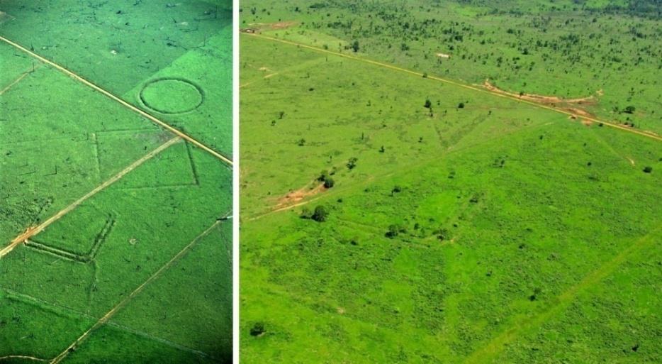
The Utility and Potential of Remote Sensing for Preservation of Archaeological Earthwork Sites in the Brazilian State of Acre, SW Amazonia
* Corresponding author
Abstract
Remote sensing forms a fundamental part of archaeological fieldwork today, and is extremely useful not only in the discovery and research, but also in the preservation of archaeological sites.
Figures
Click to enlarge
References
-
Herrmann J, Glissmann B, Sconzo P, Pfälzner P (2018) Unmanned Aerial Vehicle (UAV) Survey with Commercial-Grade Instruments: A Case Study from the Eastern Habur Archaeological Survey. Iraq Journal of Field Archaeology 43(4): 269-283.
-
Nikolakopoulos K, Soura K, Koukouvelas I, Argyropoulos N (2017) UAV vs classical aerial photogrammetry for archaeological studies. Journal of Archaeological Science: Reports 14: 758-773.
-
Sanna S, Pärssinen M, Denise S (2018) Diversity of Pre-colonial Earthworks in the Brazilian state of Acre. Journal of Field Archaeology 43(5): 362–379.
-
UNESCO (2018) World Heritage Centre: Geoglyphs of Acre.
-
Oliveira M (2014) Projetos: Uso do Lidar como ferramenta para monitoramento de florestas nativas na Amazônia: caracterização da biomassa florestal e dos impactos produzidos pelo manejo florestal na Floresta Estadual do Antimary no Estado do Acre. Embrapa Acre.
← Previous Article
<p>Andragogy in the Context of Islamic Outlook</p>
Next Article →
Women, Religion and Spirituality in South Asia “One does not have to be a Man in the Quest of Truth”
More from this journal
- The Indispensable Role of Informal Caregivers in Supporting the Aging Population
- Socio-Religious Significance of Kamakhya Temple in Guwahati, Assam
- Is Anthropology Possible?
- A Contribution to the History and Paleobiology of Harput/Elazığ Türkiye and Its Surroundings
- A Study on the Cowrie Shells of the Dimasas in Assam
- The Significance of International Organizations Cooperation in the Efficient Resolution of Global Conflict