Meteorological Data Analysis of Temperature and Rainfall in the case of Southern Ethiopia (Western Guji, Guji, and Borana zone from 1988-2018)
This research studied meteorological data analysis of temperature and rainfall of Southern Ethiopia specifically Borana, West Guji, and Guji zone starting from 1988-to 2018. The study’s main concern on analysis of nature, trends, and rate of temperature and rainfall change, and lastly focuses on the effect of climate change on crops and livestock. The researchers employed a descriptive research design and both quantitative and qualitative approaches. The researchers employed Micro- Soft Excel (Window 13), SPSS-21 version software, application of the Mann–Kendall test, and Sen's methods. The finding of this research was the temperature of all stations/zones of the study area was increased. The average temperature of moyale, Yabello, Bule Hora and Nagele is 23.47°C, 21.40°C, 19.20°C, and 17.41°C respectively and the smallest variation is observed in Bule Hora. The rainfall of the study area in all stations with the exception of Bule Hora, declined and the amount of average rainfall of Negele is much higher than others and followed by Bule Hora and the smallest rainfall was registered in Moyale. The average rainfall of Negele was 114mm, Bule Hora 80.98mm, Yabelo49.50mm and Moyale 44.89mm. The other finding of this research was crop and livestock of the study area where negatively affected. The researchers recommended-communities unity including government, private, NGO have a responsibility to minimize the effect of this climate change in the study area specifically and all developed and developing countries must come together to reduce change in climate and its negative effect in general.
Background of the Study
Global warming has the greatest effect on the biodiversity of our planet and the climatic condition of the earth. Temperature and precipitation are the two main variables of climate in the world. Climate change and development are highly intertwined: The risks of global warming could jeopardize decades of development efforts, particularly in the poorest regions of our planet. It is therefore vital to ensure Investigation Paper that development projects strengthen their beneficiaries’ capacities to confront climate change. It is also important to make sure that the same projects do not lead to excessive emissions of greenhouse gases.
Climate change concerns different sectors such as agriculture, forestry, urban and regional planning, nature conservation, water management, energy supply, and tourism for example. Climate change impacts can already be observed at many places and they will inevitably be felt more in the future [1, 2]. It is necessary to develop adaptation measures and to stimulate their implementation by decision- makers in politics, administration, economy, and society.
According to David D [3], Climate change and the need for environmental protection are global problems and call for a knowledgeable response from all countries to be effectively addressed. The term ‘climate change is used with different meanings and perspectives. In some cases, it may refer to all environmental change or include natural variability. It is most useful to think of climate change as one of several symptoms of human-produced environmental change from both global and local perspectives.
Statement of the Problem
Climate affects our lives. Africa is already a continent under pressure from climate stresses and is highly vulnerable to the impacts of climate change. Most of the factors were poverty, illiteracy and lack of skills, weak institutions, limited infrastructure, lack of technology and information, low levels of primary education and health care, poor access to resources, low management capabilities, and armed conflicts [4]. As a result of global warming, the climate in Africa is predicted to become more variable, and extreme weather events were expected to be more frequent and severe, with increasing risk to health and life. This includes increased risk of drought and flooding in new areas Few [5], Christensen [6] and inundation due to sea-level rise in the continent’s coastal areas [7].
Therefore, the main area of focus of this study was to analyze meteorological data of temperature and rainfall of Southern part of Ethiopia (Western Guji, Guji, and Borana zone) which were surrounded by lowland of Ethiopia in the Southern and South-Eastern direction which have a great influence on temperature and low rainfall of the study area.
The objective of the study
The general objective of this research was to analyze meteorological data of temperature and rainfall of Southern Ethiopia specifically Western Guji, Guji Zone, and Borana zone starting from 1988-to2018. The Specific Objective of the studies where to identify the trend of change in temperature and rainfall, indicate the rate of change in temperature and rainfall and assess the effect of climate change on crops and livestock of the study area.
The study result may provide general information for decision-makers, planners, and communities. First, the finding contribute as feedback to the Guji, West Guji, and Borana administration units as they enhance building programs for climate change adaptation to make the life of the people suitable. Secondly, identify trends and rates of change in temperature and rainfall which can help the community as they can adjust and adapt to the condition. Thirdly researchers, Tourists, NGOs, Governments and the community know about the temperature and rainfall condition of the study area to adjust their activities with the natural temperature and rainfall, as they can give attention to conserving natural resources.
Description of the Study Area and Research Methodology
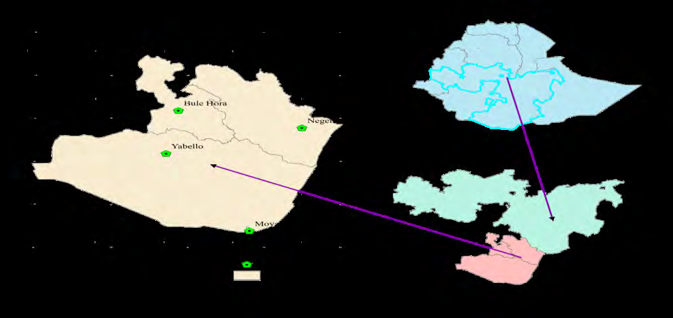
The Borana land is located in the southern part of Oromia Regional State and stretches down into northern Kenya [8]. The Borana land in Oromiya has a common boundary with Southern Ethiopia Peoples Regional State to the west ad with the Somali Regional State to the east, Kenya on the south, and west Guji on the north. The Borana Administrative Zone can be divided into two ‘the highlands mainly found in the northern and spots in the south and, the low land hills located in most of south and western Borana (Figure 1).
Research Approach and Research Design
The nature of the data was quantitative or statistical and qualitative. Because of this reason, the researchers employed both quantitative and qualitative research approaches. To conduct this study the researchers were used a descriptive research design. Jose & Gonzales [9] state that descriptive research gives a better and deeper understanding of a phenomenon which helps as a fact- finding method with adequate and accurate interpretation of the findings. The researchers used both secondary and primary data sources to collect data from Meteorological Stations and communities which were analyzed by using descriptive statistics.
Data Collection, and Data Collection Tools
The main data source of the researchers was secondary data and primary data. Secondary data from Addis Ababa Meteorological Agency, Internet, and other researches. And also the researchers used mainly documents stored in the Ethiopian Meteorological Agency and data collected by meteorological stations which are located in Western Guji, Guji, and Borana zone or the southern part of Ethiopia. To collect data from each station researchers used and selected a data collector/guider to collect accurately all 30 years of data. The researcher’s also collected primary data by interviewing and focus group discussion to gate in- depth information about the effect of climate change on crop and livestock. To collect this primary data from the community the researchers employed interviews. More than 5 interviewers participated in each station. In total 20 interviewers participate. Again to gate in-depth information about climate change and its effect on crop and livestock the researchers employed Focus Group Discussion on each station. Each focus group discussion could have an average of 8 participants.
Data Analysis
The researchers to analyze temperature and rainfall of the study area applied Micro-Soft Excel (Window 13), SPSS-21 version software application of the Mann-Kendall test [10, 11], and Sen’s methods to determine the nature and trend of meteorological data of the study area. The researchers used the Mann−Kendall statistical method to apply the annual and seasonal distribution of rainfall and temperature to detect any possible trends in the data over the study period. The Mann–Kendall (MK), commonly known as Kendall’s tau statistic, is a non-parametric test used for trend analysis. Mann [10] first used this test and Kendall [11] derived the test statistic distribution.
Positive (+) values indicate an increase over time while negative (-) values indicate a decrease. The test observes whether a random response variable monotonically increases or decreases with time.
Therefore, the researchers by the use of the Mann– Kendall rank correlation test would try to determine the trend of temperature and rainfall. This test does not take differences in the magnitude of the values into account, it only counts the number of consecutive values where the value increases or decreases compared with the prior values Yenigün [12] but by using Sen’s slope trend method the researchers would use to determine the magnitude or rate of temperature and rainfall change of the study area.
Data Analysis, Interpretation, and Discussion
Analysis of Seasonal Rainfall of the stations
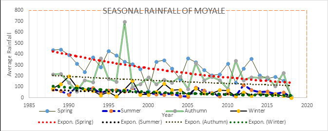
From Figure 2; From the figure someone can understand the amount of rainfall that rained in the Moyale area for continuous 30 years was declining from time to time. According to data collected from this station, the amount of rain during the spring seasons was much greater than in all other seasons. But it was highly declining than any other station.
The amount of average rain during autumn was smaller than all-season followed by winter. The trend of average rainfall during autumn was also declining with a small rate but more stagnant than all other seasons for consecutive 30 years at the study area. Over the year 1997, the autumn season was the season in which the highest amount of rain was raining for the past three decades and all seasons. And during the 2000 year, the lowest rainfall was registered for the autumn season for the past three decades.
Seasonal Rainfall of Stations
From Figure 3; researchers understand seasonal rainfall of Negele station shows us there were high variations between seasons. For consecutive 30 years, the average rainfall of summer was much greater than all other seasons and the winter season was the season in which small rain rained. While researchers refer to trend average rainfall in seasons, within summer and winter it was declined. The trend of decline was much greater in summer than winter.
But the trend of average rain in autumn and spring were increased. But the trend of the increase was greater in spring than in autumn in the study area. For the past three decades, high rainfall was registered between 1995-2000 and moderate rain 2006-2016 for three seasons except for the winter season. But, for these three seasons, the lowest rainfall was registered 2000-2005.
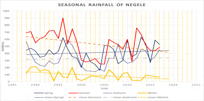
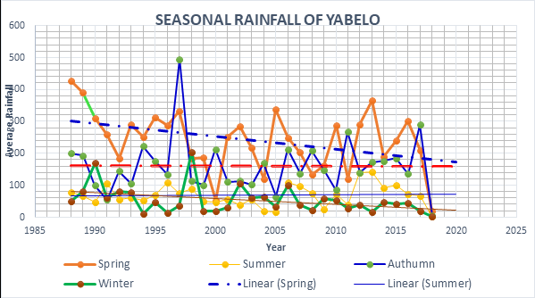
Figure 4, shows average seasonal rainfall and the trend of Yabelo. From the figure, researchers discussed as all seasons show great variation/ups and down starting from 1988-2018 G.C. The variation was much higher in spring and autumn and lower in winter. While researchers refer to the trend of the seasons, in spring and winter season was declining. The rate of decrease was higher in spring than winter. But, the trend of seasonal rainfall during autumn and summer was slightly increased. From this researchers conclude there was a seasonal variation of rainfall in Yabelo, but the trend and rate of variation between seasons were not the same. Spring season was the season in which this area gets high rainfall and winter was the smallest rainy season.
1996 was the year in which the highest rainfall was rained in autumn seasons. This season and year was the year in which the highest rainfall was registered for the past three decades followed by the 1998 spring season. The lowest rain was registered in 1991 and 2005 for autumn season in the past 30 years and for spring 2000, was the year in which lowest rain was registered in the station.
From Figure 5; the researchers understand there was seasonal variation in the amount of rainfall. The amount of rain during spring was much higher than all seasons and the season which had a small amount of rain was winter. The seasonal fluctuation was very high in spring, autumn, and summer and small in the winter season.
There was also variation in the trend of seasonal rainfall. The trend was increasing in all seasons except the winter
Analysis of Average Rainfall of All Stations
season. This means starting from 1988-2018 the trend of seasonal rainfall of Bule Hora was positive in three seasons mean, spring, autumn, and summer, but in the winter season, it was declined. For the past three decades, the highest rainfall was registered by 2013 in the spring season. Next to the spring season, autumn is the season which had the largest rain during 1997. For three seasons except winter 2003-2005 year, the lowest rain was registered.
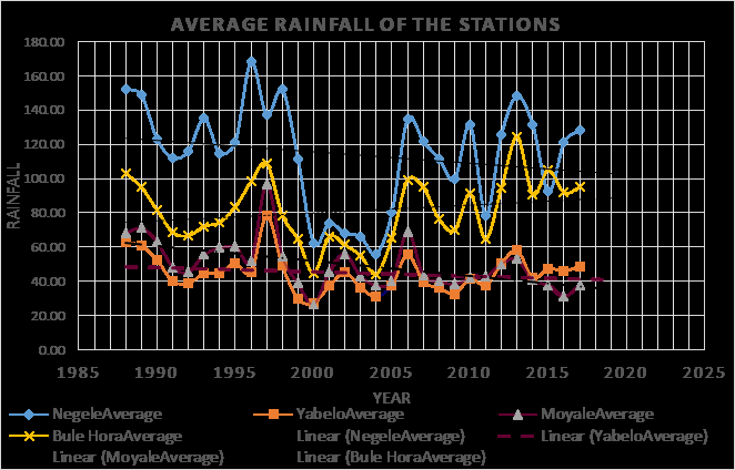
Figure 6, shows seasonal rainfall of Negelle, Yabelo, Moyale, and Bule Hora stations. From this figure, the amount of rainfall between stations had great variation. The amount of average rain of Negele was higher than all stations followed by Bule Hora and small in both Moyale and Yabelo. In all stations between 1995- 2000, there was an increase in the amount of rain in all stations. Starting from 2005 – 2018 it was increased in Bule Hora and Negele station even though there were ups and downs. Depending on the data collected and from this figure the trend of rainfall except for Bule Hora, had a negative sign mean declining. But in Bule Hora, it was increasing/ positive.
For the Negele and Bule Hora stations, the year 2000 and 2005 average rainfall was at smallest and 2005 was the year in which lowest rain registered for the past three decades for Negele and Bule Hora stations. For Moyale and Yabelo, 2000 was the year of lowest for the past three decades. Negele
Analysis of Temperature of the Study Area
station had the highest rainfall over 1996 which was the largest compared to all stations for the past three decades. The other station which had the second-largest rain was Bule Hora over 2013 but Moyale and Yabelo was the station that had the smallest rain over the 2000 year compared to others for the past 30 years.
The average rainfall of the stations of the study area where had different values as you can refers from the figure above. The average rainfall of the stations for the past three decades was 114.08 for Negele station which was the largest compared to the other stations of the study area, It was followed by Bule Hora was 80.98mm. But the least was Yabelo and Moyale station which was 44.89mm and 49.50mm respectively. From this researchers conclude, for the past 30 years Negele area got high rainfall than the other, and Yabelo area got a small amount of rain for the past 30 years.
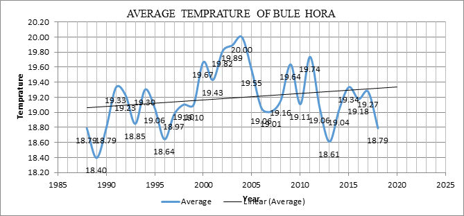
Figure 7 illustrates the distribution of the average temperature variations of data analysis results from 1988- 2018. Accordingly, the average temperature change was registered for each 30 years comparison indicated with the nearest value across for the given consecutive years. The average yearly temperature difference registered across the years was between (19.50C-19.350C). Specifically, the highest yearly average temperature registered for the year
2004 was (200C), followed by the year 2011 was (19.740C). Whereas, relatively, the lowest average yearly temperature registered for 1989 and 2013 given by (18.400C &18.610C) respectively. The result shows 1.600C maximum variation of average yearly temperature for the past three decades and in all years there was a temperature variability observed for the consecutive 30 years ago at Bule Hora station.
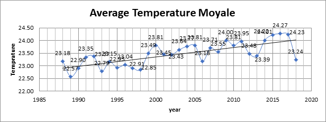
Figure 8, illustrates the average temperature variations of Moyale analysis result from 1988-2018. Accordingly, the average temperature change was registered for each 30 years comparison indicated with the nearest value across for the given consecutive years. The average yearly temperature difference registered across the years was between (22.90°C-23.81°C). Specifically, the highest yearly average temperature registered for the year 2016 was (24.27°C), followed by the year 2017 was (24.23°C). Whereas, relatively, the lowest average yearly temperature registered for 1989 and 1993 given by (22.57°C &18.61°C) respectively. The result shows 2.30°C highest variation of the average temperature for the past 30 years, there was small temperature variability observed at Moyale station.
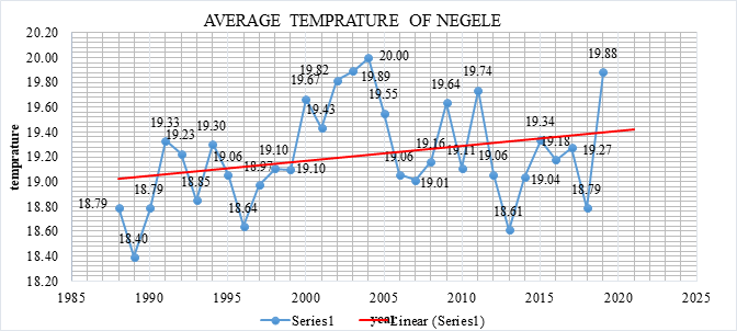
Figure 9, illustrates the average temperature variations of Negele analysis result from 1988-2018. Accordingly, the average temperature change was registered for each 30 years comparison indicated with the nearest value across for the given consecutive years. The average yearly temperature difference registered across the years was between (19°C-19.45°C). Specifically, the highest yearly average temperature registered for the year 2004 was (20°C), followed by the year 2019 was (19.880). Whereas, relatively, the lowest average yearly temperature registered for 1989 and 2013 given by (18.40°C &18.61°C) respectively. The result shows a maximum of 1.6°C variation of the average temperature for the past 30 years, there was small temperature variability observed at Negele station.
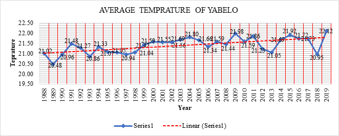
Figure 10, illustrates the average temperature variations of Yabelo analysis result from 1988-2018. Accordingly, the average temperature change was registered for each 30 years comparison indicated with the nearest value across for the given consecutive years. The average yearly temperature difference registered across the years was between (20.48°C-22.12°C).
Specifically, the highest yearly average temperature registered for the year 2018 was (22.12°C), followed by the year 2008 was (21.98°C). Whereas, relatively, the lowest average yearly temperature registered between 1989 and 1990 given by (20.48°C) followed by 1993 was (20.86°C). The result shows a maximum of 1.64°C variation of the average temperature for the past 30 years and within all other years, there was small temperature variability observed at Yabelo station.
Generally, the average temperature of all stations registered for the past three decades had a positive sign. The variation registered was a maximum of 1.64°C for Yabelo, 1.6°C for Negele, 2.30°C for Moyale, and 1.60°C for Bule Hora. Moyale was the station that registered the highest change compared to Bule Hora, labels, and Negele for the past 30 years.
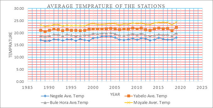
Figure 11, is about the average temperature of all stations on one figure. From this figure easily it is understandable as the average temperature of Moyale higher than all stations followed by Yabelo, Bule Hora, and Negele. Negele station was the station in which the lowest average temperature registered for the past 30 years. The average temperature of Moyale was between 23°C-25°C, for Yabelo it was 20°C-22°C, for Bule Hora it was 18°C-19°C, and for Negele it was 17.5°C-19°C. The smallest variation was registered at Bule Hora station.
From this researchers conclude average temperature of Moyale for the past 30 years was 23.47°C which was higher than all stations of the study area. The second hottest station was Yabelo station which had 21.40°C. Negele station had 17.41°C for the past three decades and which was the station registered a small temperature compared to the others. And it was followed by Bule Hora station which had 19.20°C.
Analysis of climate Change Effect and Farmers perception’s on Livestock and Crops
Metrological data revealed that trends of increase in temperature and decline in rainfall pattern. The farmer’s perception on climate pattern showed trend of increasing in temperature and decreasing rainfall. Based on this researchers understudied strongly confirmed the variability of climate in the study area.
Based on this, the researchers in order to answer the last objective of this research i.e. to assess the effect of climate change on crop and livestock of the study area assessed the farmers understand about situation and effect of climate. Based on this by the use of data collection tools like FGD, Key informant interview, and observation huge data were collected. This indigenous knowledge was often passed from one generation to the other. Participants reported that most pastoralists particularly the elders had a profound knowledge on their seasonal weather condition forecasting (monitoring and prediction) using their indigenous knowledge. Based on FGD, Key informant interview findings, observing tree/ plant phenology, wind direction, bee movement, animal behavioral change, special bird movement, moon and star were indigenous methods of seasonal weather situation forecasting in the study area.
For stance, when broadleaf tree/plant removed or budding their leaves naturally, pastoral communities forecast the rain condition (going and coming time) and even they predict whether it normal, above or below the normal through observing that how much those trees covered by leaves. When trees leaved enough on its all branches, they expect that the coming rain will likely a good enough, whereas it leaved less, the rain will also likely below normal. On the other hand, pastoral communities were followed /mobile to the direction of the area where the bee moved. Because, they believed that those areas will likely having a good condition for their livestock production.
A wind direction was also one of indicator that local communities used to forecast a rain. According to FGD and key informant interview report, in the study area wind blowing to the direction of South East and North West for long rain (Badheessaa) and short rain season (Hageyya) respectively. But, when the directions of wind changed from the normal, pastoral communities predict that the rainfall will likely be changed from the normal trends. Especially, when livestock leaved their home area and research for more pasture even during nighttime, local communities forecast that shortage of pasture (drought) will facing them. Finally, moon and star were also meaning of forecasting method in the study area. Pastoral communities predict the rain condition based on color of mood and star. When moon makes its full moon (fully circled) and reddish color, the rain will likely good enough. Based on all these, they make adjustments in all their livelihood activities. In line to this finding Luseno W [13] reported that the Borana pastoralists in the southern Ethiopia and northern Kenya forecast the future climate situation of their area based on different features, such as cow intestine reading and interpretation, livestock behavior patterns, birds, stars, clouds observation. Egeru A [14] also depicted that indigenous knowledge enabled the traditional people in France to build ability to predict weather phenomena based on plant and animal behaviors and the movements of stars or other natural phenomena available in the area.
Climate change affected many sectors, including water resources, agriculture and food security, infrastructures, ecosystems and biodiversity, human health and coastal zones. Moreover, climate change can affect agriculture in a variety of ways. However, one of the objective of this research was focused on the climate change impacts on agriculture specifically on livestock and crop production due to high dependence of agriculture on climate.
This is due to the fact that climate change exerts multiple stresses on the biophysical as well as the social and institutional environments that impacts agricultural production. Some of the induced changes are expected to be immediate, while others involve gradual shifts in temperature, vegetation cover and species distributions. Climate change is expected to, and in parts of Africa has already begun to, alter the dynamics of drought, rainfall and heat waves, and trigger secondary stresses such as the spread of pests, increased competition for resources, and biodiversity losses Christensen [6].
There is growing evidence that climate change has had negative effects on livestock and crop production. Moreover, there is a widespread agreement that agriculture, mainly in developing countries, is the sector which is most negatively affected by climate change IPCC [15]. Besides, Africa’s agriculture is hard hit with impacts of climate change due to its low level of economic development and adaptive capacity. This is what we are referring in Ethiopia at this time especially in low land part of Ethiopia like Borena, Somalia, Lowland part of West and East Guji zone. In Borena and some part of Both Guji zone frankly we observed more than 1million livestock died and crop production declined. Decline in amount of rainfall and increase in temperature in study area which we observed in 2020/2021 shown real change of the climate.
Based on this, the researchers also asked about effect of climate change on crop and livestock. The participant said that crop and livestock were negatively affected because of climate change. The negative effect was more sever in Borana zone than Guji. According to respondents negative effect of climate change on livestock caused death of livestock increased, resistance capacity of livestock is declined, reduction in livestock production likes milk and etc. This result is also supported by different authors like Hannah Reid [16]. He stated that livestock:
- Decreased livestock disease resistance, weight, productivity and numbers due to longer dry seasons
- Increased livestock death due to droughts and heavy precipitation events
- Lower livestock prices
- Reduced livestock products, particularly milk (mostly mentioned by women)
- Disturbance of animal breeding Cycles Other authors also argued that Climate change has a major challenge to livestock production in the pastoral system through its impacts on forage production, water availability, disease risks and thermal stresses [17]. Localized evidence from pastoral areas in southern and southeastern parts of Ethiopia (e.g. Borana) highlights decreasing rainfall trends being a major cause of declining livestock production [18, 19], also stated that drought is the most crucial climatic variable that cause decline in pastoral livestock production. Other studies also reported that drought have frequently affected Guji - Borana pastoralists of southern Ethiopia, causing substantial livestock losses, declining agricultural production, and food insecurity [20].
As the researchers called Getenet and Woldeamlak [21] wrote the practical implications for local scale agricultural planning, natural resources management and planning for adaptation to climate change, which ought to take into account potential impacts of rainfall variability in the area.
Rainfall variability has historically been a heavy burden on the economy, society and environment of Ethiopia. For instance, World Bank (2006) states that “hydrological variability (including droughts and floods) costs the Ethiopian economy 38% of its potential growth rate”.
In spite of such a high degree of vulnerability, studies related to rainfall and temperature characteristics and hydrological extremes, impacts of such extremes on local communities and adaptation options are very few in the country [22]. Hence, more work needs to be done to better understand small scale changes in daily rainfall behavior as any change in rainfall distribution and negative trends associated with climate change will have serious implications on national food security and economic development. Combining rainfall and temperature data analysis with analysis of stream discharge data will provide additional information on impacts of climate change which support the finding of this study [23, 24].
Conclusion and Recommendation
Conclusion
The main objective of the study is to analyze meteorological data of temperature and rainfall of Southern Ethiopia specifically Western Guji, Guji Zone, and Borana zone starting from 1988-to 2018. The result of the study related to rainfall was declining in all stations with the exception of Bule Hora [25]. The rainfall of Moyale is higher in spring than in any other season but declines than in another season. In Negelle station the summer season is experienced with higher rainfall than other seasons winter season is experienced low rainfall, but in both seasons it was declining. Rainfall of Yabello is higher during the spring season and lower during the winter season. Bule Hora station is also characterized by higher rainfall in the summer season and low in the winter season [26].
The lowest average rainfall was registered in all stations in 2000 G.C. In 1997, the station’s highest rainfall was registered with exception of Bule Hora station. 2003 with the exception of Moyale all stations registered higher rainfall. The average rainfall of Moyale was 96.8mm and 26.6mm highest and lowest respectively. For Bule Hora highest and lowest average rainfall was 124, 32mm, and 44mm highest, and lowest respectively. The average rainfall of Negelle is higher than all other stations followed by Bule Hora station and the smallest at Moyale. The average rainfall of Negelle was 114.06mm, 80.98mm for Bule Hora, 44.89mm for Yabello, and 49.50mm respectively.
The maximum and minimum temperature of Bule Hora station was above 25°C and 14.5°C with the exception of
1989, 1996, and 2013. Maximum and minimum temperature of Moyale was 20°C and 17.5°C. Average temperature of Moyale was 23.5-240C for the past 30 year [27]. The maximum and minimum temperature of Negelle was 25°C and 14°C. Average temperature of Negelle was 19.5°C. For Yabello maximum and minimum temperatures were 27.6°C and 15.64°C.The average temperature of the station was 21.6. The average temperature of Moyale is the highest than other station for the past 30 years and lowest in Negelle. The average temperature in stations showed increases and the variation is lowest in Bule Hora station [28].
The effect of change in temperature and rainfall for the past three decades is very serious on agricultural activities especially on crop production and livestock. Because of the increase in the maximum temperature and decline in rainfall crop production and livestock decline seriously. According to respondents the negative effect of change in temperature and rainfall is very serious in Moyale, Yabello, Negell, and Bule Hora stations.
Recommendation
Improving very low adaptive capacity is must to minimize or to solve the problem. Therefore, the government, NGO’s, Private sectors, including entrepreneurship must increase the awareness of the local community about climate change and its effect by preparing training for the community and local leaders.
In Borena and Both Guji zone there are number of local and international NGOs who are working on natural resource, Environment, social and political issue. If the government put direction for the NGO’s as they can work on sustaining the environment and community after certain year it is possible observing sustain environment, sustain people and reduced effect of climate change.
Policy makers while they prepare policy especially on the lowland part of Ethiopia not only in the study area must give care for the community and make as they can highly participate in policy formulation because no one knows about their problem, environment, area of their interest. Then while they participate as such it is possible policy formulated to implement. This means our policy formulation must follow bottom up approach.
The issue of climate change is not only the issue of one Government, local NGO, and local private and local community; rather it is the issue of world. Therefore, climate change is the global issue but what the local government, local NGO, local communities do wherever and whenever cooperatively it is possible reducing the effect of climate change to the local environment specifically and to the world in general.
Preparing area of storage and storing livestock food, water storage and any other necessary things. To investigate the level of effect of climate change on livestock production, crop production and living standard of the community in general other researcher/s, scholars can highly participate on it. Because it need more investigation.
References
-
Chmielewski FM, Blümel K, Henniges Y, Müller A (2009) Klimawandel und Obstbau in Deutschland. BMBF joint project underhe coordination of Humboldt University of Berlin.
-
Henson R (2011) the rough guide to climate change, pp: 406.
-
David D Houghton (2002) Introduction to climate change: Lecture notes for meteorologists. World Meteorological Organization, pp: 131.
-
UNDP (2006) Human Development Report 2006 Beyond Scarcity: Power, poverty and the global water crisis. United Nations Development Program.
-
Few R, Ahern M, Matthies F, Kovats S (2004) Floods, health and climate change: a strategic review. Tyndall Centre for Climate Change Research, pp: 63.
-
Christensen JH, Hewitson B, Busuioc A, Chen A, Gao X, et al. (2007) Regional Climate Projections. Climate Change 2007, pp: 847-940.
-
McMichael AJ, Campbell Lendrum D, Kovats RS, Edwards S, Wilkinson P, et al. (2004) Climate Change. In: Ezzati M et al, (Eds.) Comparative Quantification of Health Risks: Global and Regional Burden of Disease due to Selected Major Risk Factors. World Health Organization 2.
-
Ayalew D (2002) Guddifacha; adaptation and practice in Oromo society with particular reference to Borana Oromo.
-
Jose F, Gonzales (1993) Methods of research and thesis writing. Paris National Boore, Accept Marulas.
-
Mann HB (1945) Nonparametric tests against trend. Econometrical: Journal of the Econometric Society 13(3): 245-259.
-
Kendall MG (1948) Rank correlation methods. Charles Griffin, London.
-
Yenigün K, Gümüş V, Bulut H (2008) Trends in streamflow of the Euphrates basin, Turkey. Proceedings of the Institution of Civil Engineers - Water Management 161(4): 189-198.
-
Luseno W, Mcpeak J, Barrett C, Little P, Getachew G (2003) Assessing the Value of Climate Forecast Information for Pastoralists: Evidence from Southern Ethiopia and Northern Kenya. World Development 31(9): 1477-1494.
-
Egeru A (2012) Role of Indigenous knowledge in Climate change Adaptation: A case of the Teso Sub-Region, Eastern Uganda. Indian Journal of Traditional Knowledge 11(2): 217-224.
-
IPCC (2007) Climate Change 2007: impacts, adaptation, and vulnerability: summary for policymakers and technical summary. Intergovernmental Panel on Climate Change, pp: 116.
-
Reid H, Faulkner L, Weiser A (2013) the role of community based natural resource management in climate change adaptation in Ethiopia. Climate change, pp: 67.
-
Nardone A, Ronchi B, Lacetera N, Ranieri M, Bernabucci U (2010) Effects of climate changes on animal production and sustainability of livestock systems. Livestock Science 130(3): 57-69.
-
Riche B, Hachileka E, Awuor C, Hammill A (2009) Climate-related vulnerability and adaptive capacity in Ethiopia’s Borana and Somali communities. IISD report.
-
Angassa A, Oba G (2013) Cattle herd vulnerability to rainfall variability: responses to two management scenarios in southern Ethiopia. Tropical Anti Health and Prod 45(3): 715-721.
-
Megersa B, Markemann A, Angassa A, Zárate A (2013) The role of livestock diversification in ensuring household food security under a changing climate in Borana, Ethiopia. Food Security 6(1): 15-28.
-
Kebede G, Bewket W (2009) Variations in rainfall and extreme event indices in the wettest part of Ethiopia. Ethiopian Journal of Science 32(2).
-
Asebe RD (2007) Ethnicty and Inter-ethnic Relations: The Ethiopian experiment and the case of Guji and Gedeo. Master of Philosophy in Indigenous Studies.
-
Ensermu K, Sebsebe D, Zerihun W, Edwards S (1992) Some threatened Endemic Plants of Ethiopia. NAPRECA Monograph. Series 2: 35-55.
-
IPCC (2001) Climate Change Synthesis Report: Third Assessment Report of the Intergovernmental Panel on Climate Change.
-
Tadese (2004) The Pride of Guji Oromos; An Essay on Cultural and self-esteem. Journal of Oromo Studies 11(2): 13-27.
-
UNEP FI (2007) Insuring for sustainability: Why and how the leaders are doing it. The inaugural report of the Insurance Working Group of the United Nations Environment Programme Finance Initiative.
-
UNFCCC (2007) Climate Change: Impacts, Vulnerabilities and Adaptation in Developing Countries. United Nations Framework Convention on Climate Change.
-
WMO (2014) Scientific Assessment of Ozone Depletion: 2014. World Meteorological Organization, Global Ozone Research and Monitoring Project - Report No. 55.
- Lessons to Learn: Trees are More than the Lungs of the World
- Community Forestry Enterprises as a Model for Sustainable Forest Development: The Case Of The "Baja Tarahumara" in Chihuahua, Mexico
- Ecological and Socio-Economic Impacts of Chromolaena odorata and Mesosphaerum suaveolens, Two Invasive Alien Species in Central and Southern Benin, West Africa
- Epigenetic Sustainability: Modeling the Human Factor as a Natural Resource through Science 4.0 and the NR3C1 Biological Pilot
- Growth-at-Risk: A Framework for Assessing Economic Vulnerability
- The Rural Territory as a Socioecological System for the Management of Public Policy for Sustainable Rural Development