Human-Induced Bushfires Threat to Biodiversity in the Noun Valley, Cameroon
The study examines the relationship between bushfires and their impact on the flora, fauna, and soil of the Noun Valley. This was done using remotely sensed data from MODIS Fire and Global Water Pack datasets and field observations to arrive at the desired results. During the height of the dry season, various plant species in the wetland forests, grasslands, and cultivated fields, such as eucalyptus, palm trees, coffee, and cocoa, are highly susceptible to fire damage. Refugial forests, shrubs, and pasture lands on the valley's hillsides are particularly at risk, often due to fires sparked by cattle grazers moving towards the wetlands at the start of the dry season. The valley's significant agricultural potential has increased the incidence of humaninduced fires in the riparian villages. As the vegetation experiences stress, the safety of many animal and bird species is compromised as their habitats and food sources are gradually destroyed. The valley's diverse ecosystems respond differently to bushfires in terms of recovery, impacting the survival of habitats and potentially leading to the migration of species to safer areas. Mitigation strategies are essential to reduce the impact of bushfires, and it is crucial to promote behavioural changes,community awareness, and policy adjustments. Accurately predicting the effects and specific risks of similar incidents remains a challenge.
Introduction
The global environment is deteriorating as a result of a variety of variables, including human and climatic influences. Human-induced fires burn through the vegetal cover every year, weakening and creating fragile ecosystems [1]. The phenomenon of bushfire has long captivated the scientific community [2]. Several authors, scientists, and managers particularly those controlling natural conservation areas, saw fire as a scourge and a severe threat to vegetation [3]. Bushfires can be initiated by natural causes such as lightning, but most commonly by human actions such as arson, ignition during agricultural clearing, campfires, arcing of power lines, cigarettes and dropped matches, uncontrolled fire escapes, machine chips, and ignition for hunting and grazing [4]. They spread based on the type and quantity of available fuel wood. Everything from trees, undergrowth and dry grassy fields make up the fuel. Wind provides the fire with extra oxygen that pushes it across the land at a faster rate. Large violent bushfires can produce winds of their own called fire whirls. These are like tornadoes and are the result of vortices caused by the heat of the fire. When these vortexes are titled from horizontal to vertical, it creates fire turbulence. Fire whirls have been known to hurl flaming logs and debris over considerable distances. Further research reveals that, because of changes in the climate the upcoming fires will be more ferocious, lasting longer and enhanced further by stronger winds [5].
The impact of fire on vegetation and its use by the population appears from the first documents relating to the study of Savannah vegetation in Africa [6, 7]. In Cameroon, we distinguish early fires in November (start of dry season), intermediate fires from January – February (mid-dry season), late fires between April and May (end of dry season), and counter-season fires in June and July (Full rainy season) [8]. Fire is a constant element in the Noun Valley. Most often spontaneous, sometimes controlled, it is considered to be an essential factor in the management of ecosystems. It is important in the understanding of the relationships between fauna and their habitats, evolution of food availability as well as the monitoring of wildlife distribution.
Study Area and Methods
The Noun Valley is situated along the Noun River in the western part of Cameroon. Originating at Lake Oku (6°11′34″N, 10°27′14″E), the river flows south and is joined by the Monoun River before continuing south between the mountains Ngotsetzezan and Mount Yahou. It then turns east at approximately 5° N latitude and meets the Mbam River (4°54′42″N, 11°06′02″E), a tributary of the Sanaga River. The valley serves as the boundary between the Bamiléké area and the Bamun area and has played a significant role in the history of the Tikars and the Bamiléké people. The Noun Valley spans across three regions: North West (from Bui- Oku massif across Ngoketunjia), West (Bambotous, Noun, Mifi, Koung-Khi, Nde), and the Centre Region (Mbam and Inoubou) (Figure 1).
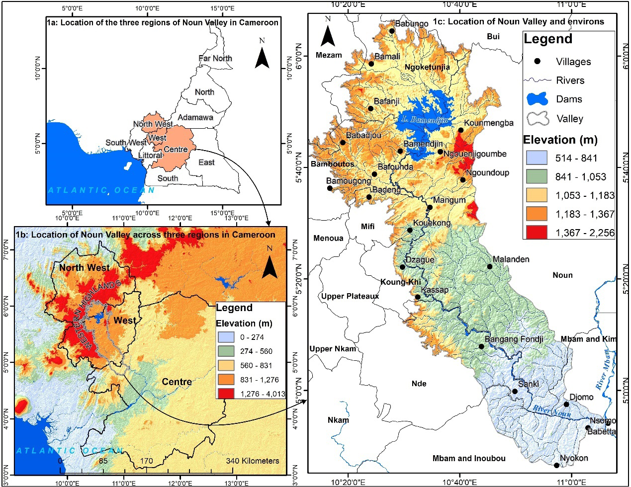
In 1975, the Noun River was dammed at Bamendjing (5°41′55″N 10°30′03″E), resulting in the creation of a reservoir of the same name. At its maximum, the reservoir is 32 km long and 27 km wide, with a surface area that varies between 150 km2 and 300 km2. The Noun River used to host hippopotamuses, and the dam area was described as the Lake of Hippos by many who visited this valley in the early 1980s. The hippopotamus, also called the hippo, common hippopotamus, or river hippopotamus, is a large, mostly herbivorous, semi-aquatic mammal and ungulate native to sub-Saharan Africa. It is one of only two extant species in the family Hippopotamidae, the other being the pygmy hippopotamus. The name comes from the ancient Greek for ‘river horse’. According to fishermen in the Bamendjin area, Kouoptamou, and Bangourain, the last hippo was seen in the lake in 2017. They were highly threatened by habitat loss, alongside bird species such as the palm nut vulture, the bee-eater, the hammerkop, and kingfishers. This area is characterised by two seasons: a rainy season from March to September and a dry season that runs from October to February. Annual average temperatures range from 22 to 26°C, while annual average rainfall is from 1,000-1,600 mm.
Methodology
Global observation of fire hazards has been enhanced with real-time remote sensing data. The availability of robustly calibrated, atmospherically corrected, cloud- screened, geolocated data provided by the latest generation of moderate-resolution remote sensing systems allows for major advances in satellite mapping of fire-affected areas. Prominent sensors include Moderate Resolution Imaging Spectroradiometer (MODIS) at 1km spatial resolution fire product and the newly launched Visible Infrared Imaging Radiometer Suite (VIIRS) at 375m spatial resolution (Figure 2).
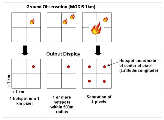
The Visible Infrared Imaging Radiometer Suite (VIIRS) was launched in October 2011 aboard the Suomi National Polar-orbiting Partnership(S-NPP) satellite, a United States mission jointly managed by the National Aeronautics and Space Administration (NASA) and the National Oceanic and Atmospheric Administration (NOAA). The satellites take a ‘snapshot’ of events as it passes over the earth. Each hotspot/active fire detection represents the centre of a pixel flagged as containing one or more fires, or other thermal anomalies (such as volcanoes). For MODIS the pixel is approximately 1km and for VIIRS the pixel is approximately 375m. The actual pixel size varies with the scan (East-West direction spatial resolution) and track (North-South spatial resolution of the scan). Based on MODIS and VIIRS active fire data, hotspots of active fires were established based on fire radiative power (FRP) obtained from satellite observations as point attribute data. Multi-temporal change detection is commonly used in the detection of changes to ecosystems. Differencing single band indices derived from multispectral pre- and post-fire images is one of the most frequently used change detection algorithms. Several remote sensing spectral indices and transformation techniques have been used to detect vegetation fires, burn severity and burn area mapping (Table 1).
| Index | Abbreviation | formula |
| Burnt Area Index | BAI | 1 / ((0.1 - Red)2 + (0.06 - NIR)2) |
| Char Soil Index | CSI | NIR / SWIR2 |
| Mid-InfraRed Burn Index | MIRBI | (10.0 * SWIR2) - (9.8 * SWIR1) + 2.0 |
| Normalized Burn Ratio | NBR | (NIR - SWIR2) / (NIR + SWIR2) |
| Burned Area Index Modified-SWIR2 | BAIML | 1/(NIR-0.6*NIR)2+(SWIR2-0.2*SWIR2)2 |
| Burned Area Index Modified-SWIR1 | BAIMs | 1/(NIR-0.6*NIR)2+(SWIR1-0.2*SWIR1)2 |
Table 1: Spectral indices and image transformation techniques used in burn severity and burned area mapping.
| Severity Level | dNBR Range (scaled by 103) | dNBR Range (not scaled) |
| Enhanced Regrwowth, high (post-fire) | -500 to -251 | -0500 to -0.251 |
| Enhanced Regrwowth, low (post-fire) | -250 to -101 | -0250 to -0.101 |
| Unburned | -100 to +99 | -0.100 to +0.99 |
| Low severity | +100 to +269 | +0.100 to +0.269 |
| Moderate-low Severity | +270 to +439 | +0.270 to +0.439 |
| Miderate-high Severity | +440 to +659 | +0.440 to +0.659 |
| High Severity | +660 to +1300 | +0.660 to +1.300 |
Table 2: Classification of Fire Severity.
Source: USGS. Table 2: Classification of Fire Severity.
A qualitative indicator used to assess fire effects within burned areas is called fire severity, widely estimated using the Normalised Burn Ratio (NBR). This study uses the normalized burn ratio (NBR) to quantify vegetation degradation from inter-annual human-induced fires using optical remote sensing data as reflected in the NIR and SWIR bands. This particular spectral behaviour of burned areas in NIR and SWIR is the basis for the development of the Normalized Burn Ratio (NBR) index. Fire severity is classified based on the scale provided by the USGS (Table 2).
Maps of dNBR classified into low-, moderate-, and high-severity classes are commonly used to assess and describe burn severity and associated ecological impacts. The total burned area for the study period (2000-2021) as per burn severity was obtained by summing up dNBR for the respective years. In its modelling, only Landsat images of likely fire months (December, January and February were used after on-screen inspection of burn scars on the image after a fire incident. This on-screen inspection of acquired images was done using a false colour composite band ratio. The MODIS 1 km fire sensor showed that the highest point fire locations within the study area are recorded from December to February each year as compared to a few fires during November, March and April. While the former represents savanna fires ignited by graziers for rangeland management, the latter mostly constituted fires in some farming plots by food crop farming in land preparation while waiting for the first rains to plant.
Field observations were also instrumental as they enabled land users in the Noun Valley to construct a bushfire preference matrix. A five-point bushfire preference index scale was used to classify farmers’ reasons for using bush: 1 (Very high), 2 (High), 3 (Medium), 4 (Low), and 5 (None).
Results and Discussion
Spatial Distribution of Human-Induced Fires
Fire is a crucial and natural component of certain ecosystems and has been used by humans for thousands of years as a land management tool to maintain ecosystems, enable regeneration, and clear debris [9]. Increasingly, bushfires are causing significant damage to vegetation, greatly impacting ecosystem processes, and shaping landscapes. The plants, animals, fungi, and insects that make up the vegetation before a fire may not be the same species that recolonize it afterwards. Some species respond well to fire, not necessarily as adaptations, but due to life forms and reproductive opportunities [10].
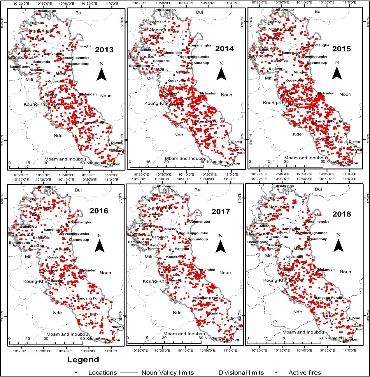
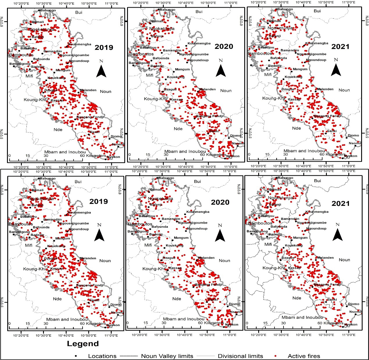
The harsh conditions of dry seasons, exacerbated by uncontrolled human activities, directly contribute to eliminating grass vegetation and increasing bare surfaces, leading to habitat loss for fauna species [11]. In the hilly areas, this vegetation is exposed to severe bushfires, which in turn prolongs cattle stay in wetlands after the onset of the first rains. Conversely, farming practices, the search for fuel wood/charcoal, honey collection, and hunting result in selective burning and intentional fires to clear undesired vegetation. In the Noun Valley, fires generally result from unattended farm fires (ankara system), burning of debris, negligently discarded unquenched charcoal and cigarettes, and intentional acts of arson. Fire dynamics within the Noun Valley vary over time and space. Its fluctuation is not consistent and does not correspond to years. Some years record high fires while others record fewer fires (Figures 3-5).
The years 2000, 2001, and 2021 were mild fire years (recording active fires ranging from 168-465), whereas other years within the 2003-2006 timeframe, 2008 and 2011 were considered as burning years (recording 1000-1373 active fires). They were years with upward burning and browning trends such as 2002 (817 active fires), 2009 (909), 2010 (907), and 2015 (960).
The land use in the area is dominated by rainfed agriculture and pastoral nomadism, practised by sedentary Mbororo nomads and some wealthy elites. From 2000 to 2021, the MODIS active fire product recorded a total of 17208 active fires in the Noun Valley. Human-induced grassland fires in the area followed seasonal patterns, with fires being most prevalent during dry periods when the fuel load is at its peak, typically from late November to early April each year.
The peak fire months in the area are December, January, and February. Some fires also occur in November, March, and April. Fires in late November and early March to April are mainly started by rainfed crop farmers during land preparation, while many fires in December, January, and February (the peak dry season) are ignited by grazers to manage rangelands and regenerate pasture. These farmers’ choice of bushfires is because it is less expensive, time-saving, less labour intensive, and easier source to get fuelwood and charcoal, weed and game hunting (Table 3).
Persistent rangeland fires over the years have led to a decline in vegetation health and land productivity. Additionally, annual biomass burning has increased soil fragility, raising the risk of soil degradation and loss due to the reduction of soil protective cover and organic residue. These environmental impacts have had serious implications for wetland soils, vegetation, water levels, and biodiversity. As a result, mutations have affected natural wetland processes through habitat disturbances and persistent loss and degradation of wetlands in the Noun Valley.
| Scale of Preference | |||||
|---|---|---|---|---|---|
| Indicators | 1 | 2 | 3 | 4 | 5 |
| Indicators | |||||
| Less expensive | |||||
| Saves time | |||||
| Less labour intensive | |||||
| Assures fuel wood & charcoal | |||||
| Weed control | |||||
| Eases hunting | |||||
Table 3: The bush fire preference matrix in the Noun Valley.
1: Very high, 2: High, 3: Medium, 4: Low, 5: None Table 3: The bush fire preference matrix in the Noun Valley.
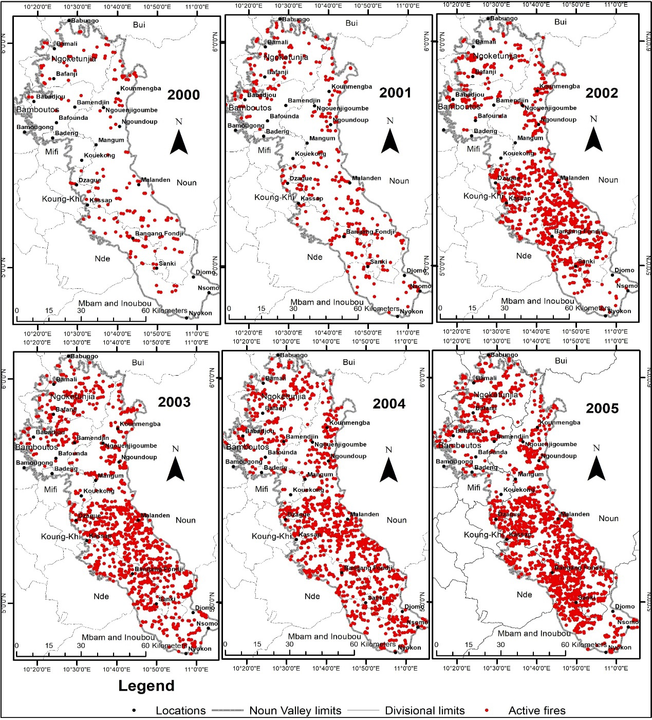
Source: MODIS active fire product Archives (NASA, 2022). Figure 3: Human-induced fires in the Noun Valley from 2000 – 2005.
Bushfire Effects on Soils in the Noun Valley
When the fire is not controlled, bushfires can be very destructive to plant resources. At the same time, the rural population of the Noun Valley needs the soil for agriculture and other livelihood activities such as grazing, hunting, and fuelwood (charcoal) production. In this area, fire is preferred for clearing the vegetation because it is less costly [12]. state that young plants can be killed and fruit setting can be perturbed by severe fire. Repeated bushfires reduce the rate of recruitment in the tree population, and most seedlings will not have the chance to grow into mature trees. With some species, the heat provided by the fire breaks the dormancy of the seed and favours good germination. Seeds such as the Leguminosae have a good germination rate after fire [13]. These fires expose the soil to agents of erosion such as wind in the dry season and water from rainfall in the rainy season. Runoff on slopes easily erodes the exposed soil and creates deep gullies, some of which measure up to 80m long, 50cm wide, and about 30cm deep. On some fairly overgrazed slopes on the western part of the upper Nun area alone, it was estimated that more than one centimetre of topsoil is removed every year [14].
Effects of Bush Fire on the Vegetation in the Noun Valley
The construction of the Bamendjim Dam has had detrimental effects, exacerbated by climate variations. This has led to the submergence of swamp forests, raffia palm bushes, and pasture lands in the upper section of the valley, which are used during the dry season for agro- pastoral services [15]. Furthermore, the release of water only when needed at the power station in Edea has exposed the vegetation along the riverine wetlands to bushfires. As a result, dry season farming, hunting, and fuel wood (charcoal) production have increased, leading to the extensive use of bushfires for clearing. The recurrent fires have significantly reduced the forest vegetation, gradually transforming trees into grasslands and grasslands into bare soils, halting photosynthetic activities due to smoke [16].
The repeated fires have also hindered the recruitment rate in tree populations, preventing many seedlings from reaching maturity. However, it has helped break seed dormancy and facilitated good germination for some species, although such species are rare in the Noun Valley [17]. The Raffia palm bushes, known for their fire resistance, play a crucial role in the valley’s vegetation. These bushes have been integral to the culture and livelihoods of the people in the entire valley, with many households depending on them for their livelihood. Despite customary laws protecting them, the increasing population has posed a constant threat to the existence of these bushes. Overuse of the remaining bushes away from flood waters has led to their rapid disappearance in the valley. In the southern part of the valley, from Ntonga to Kon-Yambetta, patches of forest still exist, but they are threatened by uncontrolled bushfires due to the creation of cocoa and palm estates.
Changes in Fauna in the Noun Valley
The vegetal cover serves as a habitat for various animals, fishes, birds, and waterfowl. When a fire occurs, it can have immediate fatal effects on fauna. Additionally, the indirect effects of fire on fauna can be substantial, leading to long- term consequences such as reproductive disorders, stress, territorial loss, habitat destruction or exposure, distortions of the food chain, migration, and even extinction of species [18]. The Noun Valley ecosystem’s edaphic, hydrographic, and phytogeography conditions favoured a diverse population of animals, fish, and birds. The floodplains of the valley provided a habitat for rich biodiversity in the wetlands. Decades ago, before the creation of the UNVDA and the dam in the 1970s, the freshness of the swamp and marsh vegetation in the dry season remained relatively stable. This stable condition, coupled with permanent swamps such as the Mbukong swamp forest and the Titayavkov swamp forest, provided a conducive environment for wildlife. These areas were generally inaccessible before the 1970s, resulting in limited human disturbance to wildlife in the entire valley.
The swamp forests and marshes also served as a good habitat for invertebrates such as crabs, frogs, and lobsters, which were a major food source for waterfowls. These areas also supported many fish, amphibians, reptiles, and mammals in the wetland Bush fires directly contribute to the loss of key organisms in forest ecosystems, such as pollinators, invertebrates, and decomposers. Without these organisms, the recovery rate of the vegetal cover is significantly slowed down [19].
Human encroachment has accelerated the effects of climate change in these areas, resulting in drastic consequences for the wildlife in the valley. The intentional and unintentional modifications of the natural vegetation with bushfires have had an immediate effect on the habitat for most wildlife in the valley. These repeated bushfires have exposed once safe havens of wildlife to direct sunlight, the harshness of the dry season, floods, agents of soil erosion, and the destructive effects of winds. This change in the ecological character of the valley has had direct consequences on the fish, birds, waterfowl, and animals. Most carnivores in this area, which are under extinction, have migrated further south in the Ntonga, Makenene, Ndiki, and Mbam areas, giving way to herbivores due to over-hunting, with many species becoming rare by the day [20].
Most animals only migrate into the valley occasionally. For example, monkeys mostly invade the Noun Valley during the maize cultivation period. These animals live in distant forest areas and surrounding hills, where they flee from continuous habitat destruction, exposure, and threats from bushfires. Some of the animals that used to inhabit this area have almost completely disappeared, such as the large “water antelope”. The population of wild rabbits has multiplied in the valley, becoming very visible during the dry season due to transhumance. Hunters have noted the increase in the number of wild rabbits in the past years. The change in habitat and subsequent outmigration of wildlife (carnivores) has favoured the multiplication of rabbits, which are herbivores ecologically linked and often present in their numbers in the hilly areas surrounding the valley with dry conditions usually associated with cattle rearing. Their presence in the Ndop and Ber plains, Noun, Bamboutos, and Nde areas has been justified by the increasing colonization of the former flood plains by this type of mountain vegetation, more resistant to fire. Conclusion The Noun Valley experiences frequent bushfires, which are a significant cause of biodiversity loss. Over 22 years, it has been observed that these fires lead to natural resource degradation, including vegetal mortality, soil destruction, fertility loss, erosion, and adverse effects on water processes. These fires also disrupt the environment’s ability to regenerate and modify the structure and functioning of the Valley’s ecosystems. The rural population has taken some measures to manage bushfires, such as using fire breaks and improving crop species. However, more needs to be done to implement early warning systems, conduct environmental patrols, and educate the community about bushfire management. It is recommended that further studies be conducted to understand the specific effects of bushfires on the Noun Valley’s fauna and flora species.
References
-
Dahan KS, Kasei RA (2022) Overview of Researches on Bush Fires for Natural Resources and Environmental Management in Ghana: A Review. Environmental and Natural Research 12(1): 48-61.
-
Valea F, Ballouche A (2012) Bush fires in West Africa: environmental constraints or environmental management tool?. The example of Burkina Faso. Territoires d’Afrique (3): 36-47.
-
Aubreville A (1949) Climats, forets et desertification de l’Afrique tropicale. Societe d’editions geographiques, maritimes et colonials, Paris, USA, pp: 351.
-
Behera SK, Sahu SK, Pradhan B (2020) Bushfire Study: Causes, Effects and Risks to the Ecosystem due to Changes in Climate. International Journal of Modern Agriculture 9(3): 579-589.
-
Sullivan A, McCaw L, Gomes Da Cruz M, Mathews S, Ellis P (2021) Fuel, Fire Weather and Fire Behaviour in Australian Ecosystem. In: Bradstoc RA, Gill AM, et al. (Eds.), Flammable Australia: Fire Regimes, Biodiversity and Ecosystems in a Changing World, CSIRO Publishing, Edinburgh, pp: 51-77.
-
Monnier Y (1968) Les effets des feux de brousse sur une savane preforestiere de cote d’Ivoire, Etudes eburnennes, XI, Abidjan pp: 260.
-
Bruzon V (1994) Les pratiques du feu en Afrique subhumide, exemple des milieux savanicoles de la Centrafrique et de la Cote d’Ivoire” in Blanc-PamarrdCh et Boutrais J, A lacroisee des chemins, Paris, ORSTOM pp: 147-163.
-
Dadem GC, Tchamba NM, Zanguim TH, Fotso RC (2020) Impacts of fires on the woody stratum of Mbam and Djerem National Park (Cameroon). International Journal of Forest and Fisheries Research 4(6): 61-74.
-
Dennis R, Meijaard E, Applegate G (2001) Impacts of human-caused fires on biodiversity and ecosystem functioning, and their causes in tropical, temperate and boreal forest biomes. CBD Technical Series Secretariat of the Convention on Biodiversity, Montreal 5: 42.
-
Martin D, Tomida M, Meacham B (2016) Environmental Impacts of Fire: Review. Fire Science Review, 5(5): 1-21.
-
Tume SJP, Kongnso ME, Nyukighan MB, Dindze NE, Njodzeka GN (2018) Stakeholders in Climate Change Communication in the Northwest Region of Cameroon. In Tume SJP, Tanyanyiwa VI (Eds.), Climate Change Perception and Changing Agents in Africa & South Asia. Vernon Press. Wilmington, Delaware. First Edition pp: 97-116.
-
Aboul Hadi SO, Omoul Kairou NM, Soule M (2023) Effects of Bush Fires on Biodiversity in West Africa Sahel: A Review. Research in Ecology 5(2): 40-50.
-
Tybirk K (1991) Regeneration des Legumeneuses ligneuses du Sahel (French) Regeneration of woody legumes in the Sahel. AAU Reports 28. Aarhus University Press: Aarhus pp: 86.
-
Kometa S, Ashu, MET (2021) Watershed degradation in the Bamendjin area of the North West Region of Cameroon and its Implication for Development. Journal of Sustainable Development 5(9): 75-84.
-
Ngala NE, Mbanga LA, Niba MLF (2023) Ecological Assessment of Wetland Dynamic and Services in the Num Valley of Cameroon. African Journal of Social Sciences 14(1): 59-72.
-
Davies SJ, Unam L (1999) Smoke-haze from the 1997 Indonesian forest fires: Effects on pollution levels, local climate, atmospheric CO2 concentrations, and tree photosynthesis. Forest Ecology and Management 124(2- 3): 137-144.
-
Nikiema A, Pasternak D, Van der Maesen LJG (2005) Identify wild food plants for sustainable agroforestry through market survey. In: Omanya GO, Pasternak D (Eds.), Sustainable Agriculture Systems for the Drylands. Proceedings of the International Symposium for Sustainable Dryland Agriculture Systems, 2–5 December 2003, Niamey, Niger. International Crops Research Institute for the Semi-Arid Tropics (ICRISAT) pp: 17-28.
-
Legge S, Woinarski J, Garnett S, Nimmo D, Scheele B (2020) Rapid analysis of impacts of the 2019-20 fires on animal species, and prioritisation of species for management response. Technical Report. Publish by the Department of Agriculture Water and the Environment pp: 1-30.
-
Bock CE, Bock JH (1990) Effects of Fire on Wildlife in Southwestern Lowland Habitats. In: Krammes JS (Ed.), Effects of Fire management of Southwester natural Resources. Proceedings of the Symposium. Tucson AZ. USDA, Fort Collins pp: 50-64.
-
Boer C (1989) Investigation of the Steps Needed to Rehabilitate the Areas of East Kalimantan Seriously Affected by Fire: Effects of the Forest Fire 1982/83 in East Kalimantan on Wildlife.
- Lessons to Learn: Trees are More than the Lungs of the World
- Community Forestry Enterprises as a Model for Sustainable Forest Development: The Case Of The "Baja Tarahumara" in Chihuahua, Mexico
- Ecological and Socio-Economic Impacts of Chromolaena odorata and Mesosphaerum suaveolens, Two Invasive Alien Species in Central and Southern Benin, West Africa
- Epigenetic Sustainability: Modeling the Human Factor as a Natural Resource through Science 4.0 and the NR3C1 Biological Pilot
- Growth-at-Risk: A Framework for Assessing Economic Vulnerability
- The Rural Territory as a Socioecological System for the Management of Public Policy for Sustainable Rural Development