Transportation-Related Human Factors in High-Altitude Regions: Review, Needs, and Novelties
The low pressure at high altitudes (above 2500 m) causes hypoxia (decreased oxygen) that affects people’s physiological and psychological characteristics. Specifically, hypoxia may affect the neural function of the brain, leading to severe cognitive deficits and a significant decline in memory function and attention. This article addresses the effect of human factors on transportation design and operation at high altitudes (HA), with some details on the Tibet-China region. Specifically, the paper first reviews the basic transportation-related concepts for high altitude, including oxygen and temperature levels, driver perception-reaction time, hazard perception, vehicle speed, and walking speed. Then, the transportation users affected by high altitudes are discussed, including drivers, pedestrians, cyclists, passengers, and others. Next, the impacts of human factors on highway design and operation for HA regions are discussed along with the research needs. Finally, recent innovations to address the challenges of HA transportation are presented, along with case studies comparing some human factors of the plateau and plain areas. This article represents a valuable reference for future research in HA regions to improve transportation design and safety.
Introduction
Generally, there is no worry about altitudes below 2500 m. However, hypoxic (decreased oxygen) at higher altitudes may cause physiological and biochemical reactions [1, 2, 3]. The plateau (high-altitude) areas exist in many countries, such as China (Qinghai-Tibet), Ethiopia (Amhara), Morocco (Atlas Mountains), Mexico (Madre Mountains), and South America (Andes Mountains). In addition, they exit over multiple countries, such as the Rocky Mountains, which extend over western Canada and the U.S. and the Himalayas, crossing China, Pakistan, India, Bhutan, and Nepal. It is estimated that 500 M people live in altitudes above 1,500 m, and 80 M people live at an altitude above 2500 m. For example, China’s Qinghai-Tibet Plateau covers an area of 2.5 M square kilometers, with an average altitude of more than 4,000 m, and has a population of 10 M people live.
Hypoxia may lead to headache, accompanied by one or more of the following, according to the International Society of Mountain Medicine [1]: (a) loss of appetite, nausea, or vomiting, (b) fatigue or weakness, (c) dizziness or light-headedness, and (d) difficulty sleeping. Specifically, hypoxia may affect the neural function of the brain, leading to severe cognitive deficits and a significant decline in memory function and attention. The health risks at high altitudes affect all aspects of life. For example, home builders in high-altitude (HA) places may install oxygen enrichment equipment in bedrooms, and oxygen is available in many hotel rooms. The highest permanent settlement known (La Rinconada) is 5,100 m. The highest recorded permanently tolerable altitude where humans have survived for two years is 5,950 m [4].
The human body can adapt to high altitudes by breathing faster, resulting in a higher heart rate and adjusting blood chemistry. At extreme altitudes, sleeping becomes very difficult, digesting food is near-impossible, and the risk of life-threatening HA pulmonary edema (fluid in the lungs) or HA cerebral edema (fluid in the brain) significantly increases [1]. Further, altitude acclimatization (body adjusting to the decreased oxygen) becomes impossible above 8,000 m ‘death zone.’ Some studies showed that people living at higher altitudes have a statistically significant higher rate of suicide. On the positive side, some research suggests that high altitude could protect against Alzheimer’s disease via the action of erythropoietin, a hormone released by the kidney in response to hypoxia [5].
For transportation systems, high altitude has good and bad effects on transportation. On the one hand, the higher the altitude, the lower the vehicle’s CO2 emission [6]. There is a linear correlation with the altitudes, where every 1000 m of altitude rise decreases CO2 emission by 5.31%. In addition, fuel consumption at 3030 m reduces by 9.5% compared with the sea level. On the other hand, high altitude adversely affects all transportation users (drivers, pedestrians, cyclists, passengers, and others). As a result, the accident rate in the plateau areas is substantially higher than in the plain areas. For example, according to the National Bureau of Statistics China, the average death toll of traffic crashes in plateau areas is nearly 50% of the national average [7]. In addition, user characteristics, such as perception-reaction time, hazard perception, visual perception, and walking speed, affect highway design and operation. These include sight distance, horizontal and vertical curve design, traffic signal design, and guide sign design. Unfortunately, however, only a few studies have addressed the impact of high altitudes on transportation design and operation.
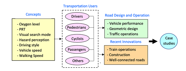
This article addresses transportation-related human factors in plateau areas, identifies the needs related to highway design and operation, and presents recent innovations to mitigate the challenges of high altitudes. The article consists of four sections (Figure 1). Section 2 presents several concepts related to transportation users at high altitudes. Section 3 describes the impact of high altitude on transportation users (vehicle drivers, pedestrians, cyclists, and passengers). Section 4 discusses the impact of high altitude on vehicle performance, highway design, and traffic operation. Section 5 presents emerging innovations, and Section 6 presents case studies.
Oxygen and Temperature Levels
The high altitude causes the barometric pressure to decrease, spreading further apart the oxygen molecules [8]. Thus, the oxygen content in each breath would be less, resulting in reduced blood oxygen levels and inefficient oxygen delivery to the brain, tissues, and mussels. At zero altitude, the oxygen level is about 21%. For every 300 m above, the oxygen level is reduced by 1%. For example, at an altitude of 900 m, the oxygen level is 18%. Similarly, at a given altitude, every 1% oxygen above 21% will reduce the given altitude (to an equivalent altitude) by 300 m. For example, at an altitude of 5000 m, people breathing 27% oxygen will have an equivalent altitude of 3200 m (1800 m reduction for a 6% oxygen level increase). This equivalent altitude is tolerable for people with some altitude acclimatization. Oxygen enrichment of room air at high altitudes improves sleep quality, daily working efficiency, and neuropsychological function. In addition, temperature decreases at high altitudes. In the absence of snow (or rain) and clouds, the temperature reduces by about 1°Celsius per 100 m up in altitude. Otherwise, the drop in temperature is 0.6°C per 100 m [9].
Perception-Reaction Time
The perception-reaction time (PRT) is commonly defined as the time it takes for a driver to perceive and respond to hazardous situations [10, 11]. The PRT comprises the following four elements, see Transportation Association of Canada [12]: (a) detection using vision capabilities to see a visual signal (detection), (b) identifying the signal and thus understanding the stimulus (Identification), (c) deciding what action to take in response to the stimulus, such as applying the brakes and turning the steering wheel (decision), and initiating the action decided upon (response). The PRT is significant in road design as it can provide adequate sight distance for drivers to avoid potential hazards.
Visual Search Mode
The drivers’ hazard perception is a part of the handling process of hazard information [13], which can be divided into three stages: visual cognition, judgment, decisions, and driving operation. As visual cognition, an excellent visual search mode is an essential prerequisite for drivers to timely and accurately perceive dangerous information while driving. Such data can ensure that drivers respond quickly and appropriately to unexpected hazardous conditions.
Hazard Perception Ability
The hazard perception skill (HPS) refers to the driver’s ability to detect and respond to potential hazards [14]. Many studies have discovered that driving experiences, road environments, and hazard scenarios may affect drivers’ HPS. For example, as the altitude increases, the air is thinner, and the driver’s psychological state will change to varying degrees, such as loss of vision, change of dynamic vision, and decline of reaction ability [15]. Drivers are unaware of their physical or mental changes at high altitudes, impairing their perception of suddenly occurring traffic hazards.
Driving Style
Depending on various personal characteristics and driving habits, drivers have different driving styles, significantly affecting their operation and reaction when faced with a potential hazard. Recently, the graphical modeling method has been confirmed to help better understand the individual features of driving behaviors. For instance, Chen F, et al. [7] developed a driving habit graph (DHG) to model drivers’ overall driving style. The DHG, composed of macro- nodes and arcs, provided a comprehensive understanding of the specific driving style of a driver. Wang C, et al. [16] applied summative statistics and graph construction to model aggressive driving behaviors and found that the graph construction achieved better performance over statistics models.
Vehicle Operating Speed
Vehicle operating speed reflects the significant influence of driver characteristics, road geometry and environment, and vehicle performance on the actual driving. The low- oxygen environment in plateau areas negatively impacts driving performance and vehicle mechanical performance. The vehicle acceleration time and distance extend while the maximum speed and grade ability decrease. As the oxygen content decreases for the driver, various cognitive abilities, including vision, hearing, memory, thinking, and attention, will decrease. The influence of the plateau environment on operating speed has been evaluated, and operating speed models for the plateau region in China have been developed [16]. For trucks, Lei et al. [17] found that altitude substantially affects the test truck’s decelerating and accelerating performance. The truck’s speed decreased faster on steep grades and increased slower on gentle grades as the altitude increased.
Walking Speed
The walking speed of pedestrians in high-altitude areas well reflects the influence of the plateau environment on pedestrians’ participation in traffic activities. As the altitude increases, the oxygen saturation of pedestrians decreases and the heart rate increases. In addition, with the decrease in the oxygen content, the physiological state of pedestrians will gradually fatigue, and the exercise capacity will decrease to a certain extent, reflecting the reduction in pedestrian walking speed at high altitudes. The influence of altitude on the walking speed of pedestrians in tunnel evacuation was evaluated by Yan G, et al. [18]. The indicators included blood oxygen saturation, heart rate, and subjective fatigue degree. The corresponding subtraction coefficient was introduced to reflect the influence of various factors on walking speed. The results show that the low oxygen environment in the plateau area negatively impacts pedestrians. For males aged 20-30, the average walking speeds inside the tunnel were 1.2 m/s, 1.0 m/s, and 0.8 m/s for altitudes of 500 m, 1950 m, and 3850 m, respectively.
Impacts on Transportation Users
Drivers of Vehicles
High altitude can significantly increase a driver’s mental workload and reduce situation awareness, see Wang X, et al. [19]. Mental workload is the portion of information processing capacity required to perform a driving task. A workload that is too high or too low is not conducive to driving safety. In addition, the increase in mental workload can lead to a rise in aggressive traffic violations. The high altitude affects driver features, such as perception-reaction time, hazard perception ability, visual search mode, and driving style. Therefore, improving situational awareness and reducing mental workload can effectively mitigate the driving risk from the high-altitude environment.
Pedestrians
People travelling at high altitudes tend to control their speed more intentionally and will try to stroll to adapt to the high-altitude environment. The walking pace is coordinated with breathing to find a suitable walking rhythm. This reflects that the overall pedestrian traffic in high-altitude areas is relatively slow and maintains an even rhythm. Intuitively, the high-altitude environment has adversely impacted traffic activities, and pedestrians are likelier to feel tired and weak [18].
Cyclists
More people are beginning to do cycling at high altitudes as a challenging, adventurous, and exploratory trip. In addition, many professional cyclists are trained at high altitudes. The thinner air at high altitudes makes the air resistant, making cycling training more effective. Riding at moderate altitudes for the first time may improve riding performance on lower altitude terrains, as the benefit of reducing air resistance outweighs the reduction in maximal aerobic power. However, Hahn AG, et al. [20] showed that long-term cycling at high altitudes led to adverse effects, such as fatigue and altitude sickness. Garvican L, et al. [21] pointed out after observing the three-week high-altitude training of cyclists that high- altitude training did not significantly increase the maximum value of hemoglobin but only increased its concentration. However, it could improve the athlete’s level.
Pedestrians-Cyclists
Pedestrians and bicycles in high-altitude areas also face serious problems, including the unpredictable impact of climatic phenomena such as heavy fog and wind in high- altitude areas on road users. A critical reason fog affects traffic safety is that it reduces the visibility of the road, which seriously interferes with pedestrians and cyclists obtaining road condition information and road environment information. This, in turn, affects decision-making behavior and the occurrence of traffic accidents. The impact of strong winds on traffic safety is mainly reflected in the following points. First, strong winds will increase vehicle driving resistance and reduce vehicle stability. Second, strong winds will cause a great disturbance to pedestrians or people riding non-motor vehicles. For example, blowing dust into their eyes or disturbing their clothes and hats will seriously distract them. The strong wind affects the walking or cycling routes, significantly increasing the probability of colliding with motor vehicles, thus causing traffic accidents [22]. Third, the low temperature in high-altitude areas cracks the road surface, causing the road surface to be discontinuous, providing a channel for precipitation to infiltrate. When the temperature turns warm, the road surface becomes muddy and slippery, reducing the adhesion of the road to the tires, and making it easier for cyclists and pedestrians to skid. Finally, in some high-altitude areas with poor air quality, cyclists and pedestrians face more significant impacts from inhalable particulate matter and smog than cars in confined spaces because cyclists and pedestrians are exposed to the road environment [23]. The world’s longest urban transit pedestrian system has been developed in Lhasa, China. The system is divided into four layers of ring roads and has formed a high-density bicycle lane system with the highest altitude in the world. More than 60% of the roads in the main urban area have been equipped with bicycle lanes [24].
Some high-altitude areas involve spiritual and cultural pursuits of holy places, attracting many pilgrims and considerably slowing traffic. There are two types of walkers: single walkers and multi-person walkers. Many Tibetans, taking pilgrims in the plateau areas, kowtow to the ground for the “body” respect to show their belief in Buddhism (Figure 2). At the same time, they constantly recite incantations in their mouths and travel thousands of kilometers for pilgrimage to the Jokhang Temple in Lhasa, a UNESCO’s World Heritage, showing great piety and persistence. Notably, the speed of the pilgrims is much less than that of normal walkers.
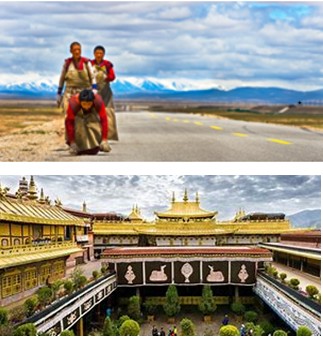
A: Pilgrims
B: Jokhang Temple Figure 2: Pedestrians’ pilgrims in the plateau areas.
Passengers
Passengers who travel to high-altitude regions would be exposed to hypoxia before and after riding the trains or public transportation. Therefore, passengers should travel first to a low altitude in the area to get used to the environment, then take public transit to a higher altitude; see Tibet Train Travel [25]. For example, tourists to Tibet can first travel to Lhasa (3650 m), the capital of Tibet, then take the train to Xining
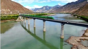
(5072 m), the capital of Qinghai. On the other hand, starting the trip from Qinghai may cause some unease on the way to Lhasa by train, thus affecting their tour program. In addition, at an altitude of more than 4500 m, some weird things may happen, such as ink-pen leaks, the explosion of vacuum- sealed food packages, and the failure of some laptops and digital music players. Fig. 3 shows a staff serving passengers on the bullet train from Lhasa to Nyingchi [26].
![Figure 3: Passengers get refreshments on the Fuxing bullet train from Lhasa to Nyingchi [26].](/fulltextimages/10340/fig_3.png)
Train passengers at high altitudes are advised to be cautious regarding several aspects [25]. First, they should take light, high-carbohydrate meals for more energy and avoid alcohol since it may increase the dehydration risk. Second, trains may stop at some high-altitude stations with beautiful views, and they should not run at the height to avoid feeling uncomfortable afterwards due to lack of oxygen. Third, since the high altitude allows the sun’s solar radiation to strike the earth more intensely, passengers can use sunscreen, sunglasses, and lip creams to protect their eyes and skin. Finally, tourists with heart problems or high/ low blood pressure should check with doctors before visiting high altitudes.
Impacts on Highway Design and Operation
Vehicle Performance
Does high altitude affect a vehicle’s performance? The answer is Yes. High altitude significantly affects vehicle performance, causing the vehicle to lose power [27]. This happens because less air is fed to the internal combustion engine. Generally, an engine loses 3% of its rated power for every about 300 m of altitude gain. That is, for an altitude of 2000 m, the engine is expected to lose 20% of your horsepower. However, the amount of lost horsepower depends on the engine size and configuration. In addition to power loss, high altitude can affect vehicle performance in two ways. First, a low-octane level should be required at high altitudes since high-octane fuels have no advantage in deficient-oxygen environments. Second, the lower temperatures and air pressure at high altitudes cause the tire pressure to drop, causing reduced handling and breaking and a drop in fuel mileage. It should be noted, however, that modern vehicles include solid air and fuel systems to compensate for air density changes.
Transportation Design
Transportation users have many parameters that affect the design and operation of transportation facilities. Table 1 summarizes, for each transportation user, the human-factor parameters and related design and operational elements. As noted, the parameters related to drivers, pedestrians, and cyclists (e.g., PRT and driver deceleration rate) mainly affect highway geometric design. In contrast, the passengers’ parameter (low oxygen) affects train and public transit design. The main design elements include stopping sight distance (SD), passing SD, decision SD, crossing SD at an intersection controlled by a stop sign on the minor road [12], railway crossing SD [28], traffic control devices [29], roundabout design [30], freeway acceleration and deceleration lanes, and sag vertical curve design [31].
For example, the stopping sight distance (SSD) is a function of the perception reaction time and deceleration rate. It is the sum of the distance travelled during the perception-reaction time and the braking distance. The braking distance is the distance to stop a vehicle once the brakes have been applied. For a level roadway, SSD is given by [12, 31] 2 0.278 0.039 v SSD Vt a = + (1) Where SSD = stopping sight distance (m), V = design speed (km/h), t = perception-reaction time (s), and a = deceleration rate (m/s2). The SSD for plateau regions is expected to be larger than for plain regions because the PRT is longer and the deceleration rate is lower.
Traffic Operations
Human factors also affect several highway operational elements, as shown in Table 1. These include yellow interval determination to avoid the dilemma zone [32], the minimum green interval for traffic signals [33], and pedestrian crossing SD [34]. For example, the minimum green interval for traffic signals on level approach is given by
0.278 ( ) 2 0.278 V W L I t a V + = + + (2) Where I = intergreen (yellow plus all-red) interval (s), t = driver’s PRT at the onset of the yellow interval(s), V = approach speed (km/h), a = deceleration rate (m/s2), W =
intersection width (m), and L = vehicle length (m). As noted, this formula depends on the driver’s PRT and deceleration rate. Therefore, larger values for I would be required in plateau regions.
Recent Innovations
Train Operation Technology
Airplanes and individual rooms have confined environments. Therefore, oxygen enrichment of the air is straightforward. However, for trains, oxygen enrichment is more challenging for several reasons [35]: (a) the volume of air oxygenated in a train (cars and gangways) is much larger, (b) oxygen concentration inside the train must be maintained despite the opening of the door at stations, and (3) waste must be disposed of without affecting the oxygen- enriched environment. Therefore, this train operation technology represents an extraordinary innovation in high- altitude transportation.
| User | Parameter | Element |
|---|---|---|
| Drivers | Perception-reaction time | - Stopping SD |
| - Passing SD | ||
| - Decision SD | ||
| - Crossing SD (intersection, railway) | ||
| - Yellow interval | ||
| - Accident reconstruction | ||
| Field of view | - Traffic control devices | |
| - Guide signs | ||
| - Roundabout design | ||
| Deceleration rate | - Stopping SD | |
| - Crossing SD | ||
| - Freeway deceleration lane | ||
| Acceleration rate | - Freeway acceleration lane | |
| Centripetal acceleration | - Spiral curve length | |
| Vertical radial acceleration | - Sag vertical curve design | |
| Pedestrians | Perception-reaction time | - Minimum green interval |
| - Crossing SD (intersection, railway) | ||
| Walking speed | - Minimum green interval | |
| - Crossing SD (intersection, railway) | ||
| Personal operating space | - Sidewalk width | |
| - Wheelchair ramps | ||
| Cyclists | Perception-reaction time | - Stopping SD |
| Cycling speed | - Stopping SD | |
| Vertical radial acceleration | - Sag vertical curve design | |
| Passengers | Oxygen level | - Train oxygen generation rate |
| - Oxygen outlets at train station stops | ||
| - Oxygen outlets in trains | ||
| Temperature level | - Train temperature regulation |
Table 1: Transportation design and operational elements affected by high altitude.
For example, the train from Golmud, Qinghai (2809 m) to Lhasa, Tibet (3658 m) in China travels at an average altitude of 4500 m for more than 14 hours [36]. Because of the high altitude, passengers may be exposed to sustained hypoxia. Therefore, the oxygen concentration in the train (which has 16 passenger cars) has been increased to 25% using oxygen generators in the train cars to address this problem. The generator typically produces 40% to 50% oxygen, which is added to the ventilation air of each car to achieve 24% to 25% oxygen concentration in the car. An oxygen concentration of 25% reduces the equivalent altitude by 1200 m. Therefore, at the train’s highest altitude (5000 m), the cabin altitude is reduced to 3800 m, which is greater than the altitude of the Lhasa terminal station. Each car’s oxygen generator unit has a panel that passengers can view, indicating the oxygen level. In addition, the train’s temperature is adjusted with the altitude, and the windows have UV-glazed coating for protection from high-altitude rays.
Railway Construction
Railway construction at high altitudes faces three main challenges: lack of oxygen, fragile ecosystem, and permafrost (Figure 4). An example is the bullet train’s electrified railway in southwest China’s Tibet. Autonomous Region (Lhasa to Nyingchi) with a design speed of 160 km/h. The single-line railway has a length of 435 km, involving 47 tunnels and 121 bridges, accounting for 75% of the route and posing tremendous challenges for construction workers. More than 130,000 workers were involved in building the railway, most of which had an altitude of more than 3,000 m.
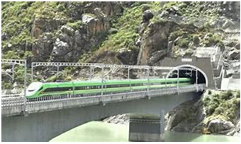
C: Tunnel
D: Bridge Figure 4: Tunnel and a bridge along the bullet train route from Lhasa to Nyingchi.
Proper aid for the construction workers was provided during the Qinghai–Tibet railway track construction, involving 80,000 workers, which was formidable. The project had 17 oxygen generators and 25 clinics with hyperbaric chambers along the track during the railway construction. In addition, the designers carefully selected the route to avoid destroying vegetation and the natural habitat of wild animals. Further, they ensured stability in permafrost regions by installing gravel embankments [35].
Engineering challenges at two tunnels are described next to demonstrate the remarkable construction innovations in this project [36]. First, the excavations were done using hand drills for the Fenghuoshan Tunnel (4905 m), which is the world’s highest-altitude railroad tunnel. The hypoxia was partially relieved using large volumes of high-concentration oxygen produced from generators outside the tunnel. First, the generators absorb nitrogen when the air is pumped through them, creating a high oxygen concentration. Then, the oxygen was pumped to the end of the tunnel in a pipe and released. The increase in oxygen was equivalent to an altitude reduction of 1200 m. In addition, a small room was constructed where workers could inhale oxygen. Second, acute mountain sickness among workers occurred during construction at the Mount Kunlun tunnel (4660 m), which is 1686 m long and believed to be the world’s longest permafrost tunnel. In this project, the medical examination of nearly 75,000 over 2.5 years, the incidence of acute mountain sickness ranged from 45% to 95%, depending on the altitude.
Well-Connected Transportation Network
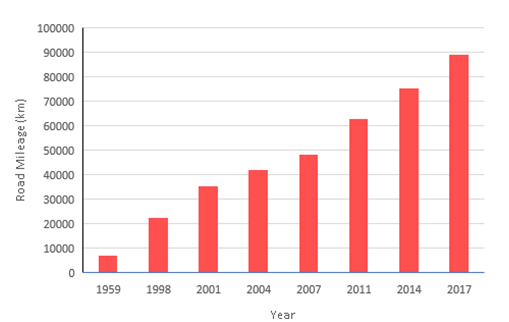
China has increasingly invested in constructing Tibet’s transportation infrastructure over the past 60 years to promote economic and social development [37], as shown in Figure 5.
The total road mileage grew from 7300 km in 1959 to 89,343 in 2017 (more than ten times increase). The developed road and train network is centred in Lhasa. Tibet has completed a five-year plan (2016-2020) for comprehensive transportation development. In addition, the region has emphasized road development in the countryside by building and upgrading 4,500 km of rural roads to link its 33 townships and 533 villages to promote poverty reduction further. Rural passenger transport lines are also launched to solve the transport difficulties for local farmers and herders.
Case Studies
Many studies have been conducted in several countries to analyze the effects of high altitudes on transportation users and people. For example, Dykiert D, et al. [38] found the reaction time in Edinburgh, Scotland, significantly increases at an altitude higher than 4000 m. Banderet L, et al. [39], In a study by the U.S. Army Research Institute of Environmental Medicine, revealed that the speed and accuracy of the military’s judgement would be substantially affected and visual acuity, dark adaptation, and color resolution decrease at altitudes higher than 3000 m. This section presents the results of five case studies conducted in the Tibet plateau related to visual perception, hazard perception ability, hazard perception-response mode, operating speed, and minimum curve radius.
Visual Perception
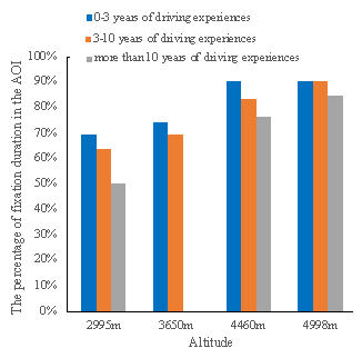
Zhang D, et al. [40] analyzed the eye movement behaviors of drivers when faced with traffic hazards in the plateau environment to examine the impact level of altitude on drivers’ perception and reaction. Nine typical traffic hazard scenarios were carried out at four locations with four different altitudes, including Linzhi (2995 m), Lhasa (3650 m), Naqu (4460 m), and Yanghu Scenic Area (4998 m) based on UC-WIN/ROAD driving simulation software. Then, drivers’ visual search modes were analyzed according to drivers’ eye movement data collected by ASL Mobile Eye monocular eye tracker. Then, the first fixation time of hazard scenarios, percentage of fixation duration in the area of interest (PFD), and average saccade amplitude (ASA) were analyzed. For example, the PFD results for different driving experiences are shown in Fig. 6. Then, the drivers at higher altitudes perceived the situation in hazard scenarios later with larger PFD in the hazardous areas and had a smaller ASA than those in low-altitude areas. These results indicated the effects of a low-oxygen environment on visual sensitivity, perception and processing ability, and visual search mode. Moreover, experienced drivers had smaller PFD and larger ASA, while drivers with a short acclimation period had smaller PFD.
Hazard Perception Ability
Wang C, et al. [41] analyzed the perception ability of four hazardous experiments at Nanjing (50 m) using driving simulation software. The hazard perception- reaction time could be specified. Significant weak negative correlations were found between perception-reaction time and age, acclimation period, and driving experience (-0.106, -0.175, and -0.191, respectively). There were no significant relationships between perception-reaction time and gender, and scenario. Then, the K-means clustering divided the drivers into three groups (Good, Medium, and Poor). Finally, the three groups’ marginal effects of linear regression models were calculated to augment the comparison. As expected, the elevation positively correlated with the perception-reaction time but indicated variance of influence effects in the three groups.
Hazard Perception-Response Mode
After analyzing the perception ability, Wang C, et al. [42] proposed a graph construction approach to model drivers’ hazard response mode hazards in plateau areas. The simulation experiments were successively conducted in the same five cities used for the hazard perception ability study. Then, according to the graph construction approach, 4 hazard response modes (HRM) for drivers were extracted (Figure 7). The symbols in the figure are defined as follows: SA (steering wheel degree), TH (throttling degree), BR (braking degree), AX (lateral acceleration), AY (longitudinal acceleration), VX (lateral speed), and VY (longitudinal speed).
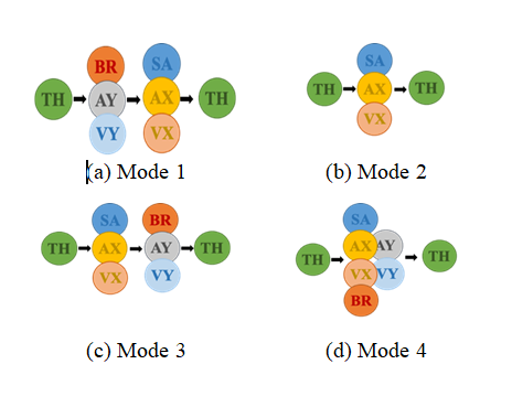
The drivers of Mode 1 tended to have good perception ability while taking efficient and expected behaviors. The drivers of Mode 3 were found to have longer hazard- response times than those of Modes 1-2. They first took the avoidance operations being turning the steering wheel. Then, they braked to pass the hazardous vehicle or pedestrian. By contrast, the drivers of Mode 4 were observed to have the worst perception ability and might be panic-stricken when encountering the hazard situations. The effects of significant variables, including scenario types, altitude, acclimation period, driving experience, and gender, filled the knowledge into the construction of HRM and risk perception ability of plateau drivers. These results showed that constructing HRM to model the driving styles of plateau drivers is feasible and effective, enabling future assistance driving systems to be better customized for drivers in such a particular condition.
Vehicle Operating Speed
To study the influence of the harsh environment in plateau areas on the operating speed of vehicles, Wang C, et al. [16] established advanced speed prediction models based on the observed actual speed data. First, the speed characteristics were observed on Lalin Highway and National Highway 318 with Bushnell’s handheld radar speedometer. Second, the stepwise regression method was proposed to determine the significant parameters and present the operating speed prediction models for the two highways. Finally, the reserved test group data was conducted to prove the validity and practicality of the proposed models. Compared to the traditional methods, the established models can produce more accurate prediction results and deeply examine the nonlinear relationships between parameters and the predicted operating speed.
Minimum Curve Radius
The peculiar natural geographical environment in high altitudes significantly influences the drivers’ psychophysiological states, enhancing drivers’ mental workload and deteriorating driving safety. Therefore, it is significant to incorporate the impacts of low-voltage and hypoxia conditions of plateau areas on drivers when examining the minimum radius of the horizontal curve applied to two-lane highways in plateau areas. Chen F, et al. [7] conducted field experiments based on the segments from Nyingchi to the Mountain Shegyla on G318. Besides, the model for the simulated experiment is established based on UC/Win-Road software to exaggerate the adequate sample size. The consistency of the field and simulated experiments is validated through the Paired Sample T-test. Sample entropy is adopted to process the collected multi- source data, including the velocity of the vehicles, heart rate, and electroencephalogram of the driver. In addition, the principal component analysis evaluates a comprehensive index (CI), which represents drivers’ psychophysiological state. Subsequently, the correlation between CI and radius is anatomized, validating that the lateral acceleration ah is the index of greatest influence on CI from the driving dynamics perspective. Values of the minimum radius of the horizontal curve of two-lane highways in the plateau area were proposed to amend the current Chinese standards. Overall, this research may play an essential guiding role in alignment design in plateaus areas and conspicuously deepen our understanding of driving safety under low-voltage and hypoxia environments theoretically and practically.
Conclusion
This article has reviewed the human factors at high altitudes and their effects on transportation users and, in turn, transportation design and operation. Based on this study, the following comments are offered:
- Considerable research was conducted for the plateau areas. The case studies showed a decline in visual sensitivity, visual search mode, and perception-reaction ability for high altitudes. In addition, there are changes in the operating speed and minimum curve radius. Therefore, the findings of these case studies provide good references for future transportation safety analysis in high-altitude areas.
- The high altitude substantially affects transportation users, impacting transportation design and operation. However, most research and developed technologies have focused on train passengers, and no studies have addressed the effect of high altitude on highway geometric design and operation. Therefore, the design and operational elements identified in this article should represent a valuable reference for future research.
- Significant innovations in train technology have been developed to mitigate the low oxygen level at high altitudes. These include oxygenating the air inside the train to tolerable levels and regulating the train’s temperature. The speed of China’s bullet trains in Tibet (160 km/h) is much lower than other high-speed trains in China (300 km/h), mainly due to the geometric restrictions of the route alignment.
- This article has focused on transportation human factors and their effect on transportation design and operation. However, several transportation areas for high altitudes, not related to human factors, warrant future research. These include asphalt paving, highway construction and maintenance, steep slope design, tunnel design and construction, road solar heating systems, green highways, and extreme weather conditions. In addition, a unique road-safety problem in the plateau areas that deserve future research is hitting unexpected cows on the roads.
- Transportation research related to high-altitude regions has been recently emerging. As more knowledge is developed on this aspect, it would be vital to incorporate it into university/college education in both Tibet and worldwide. This would help us understand how to aid the safety of high-altitude people and may even enrich our transportation knowledge of low altitudes. Hopefully, this article will motivate young researchers to explore various transportation aspects of the plateau areas to improve safety and well-being.
References
-
International Society of Mountain Medicine (2023) An altitude tutorial. Internet: Non-Physician Altitude Tutorial.
-
(2023) Effects of high altitude on humans.
-
Eastham S D (2015) Human health impacts of high altitude emissions. Massachusetts Institute of Technology, Cambridge, MA, pp: 1-159.
-
(2023) List of highest settlements.
-
Davenport L (2015) High-altitude living linked to lower Alzheimer’s risk. Medscape.
-
Ni H, Zhao W, Liu L, Li M, Fu T, et al. (2014) A research of the effects of altitude on the emissions and fuel consumption of a gasoline vehicle. Qiche Gongcheng/ Automotive Engineering 36(10): 1205-1209.
-
Chen F, Hu F, Wang C, Zhu J (2021) Minimum horizontal curve radius of two-lane highways in plateau areas: A psychophysiological approach. Presented at Annual Conference of Transportation Research Board, Washinton, DC.
-
West JB (2003) Improving oxygenation at high altitude: acclimatization and O2 enrichment. High Alt Med Biol 4(3): 389-398.
-
Rose S (2019) What happens to the temperature as altitude increases?.
-
Olson PL (1989) Driver perception response time. SAE International 98(6): 851-561.
-
Smiley A, Caird JK (2007) The Effects of cellphone and CD use on novice and experienced driver performance. Insurance Bureau of Canada, pp: 89.
-
Transportation Association of Canada (2017) Geometric design guide for Canadian roads. Ontario, Canada.
-
Ma Y, Zhang X, Ha D, Li X, Zhu Y (1999) Effects of high altitude hypoxia on human visual function. Plateau Medical J 1999(1): 37-39.
-
Crundall D, Chapman P, Phelps N, Underwood G (2003) Eye movements and hazard perception in police pursuit and emergency response driving. J Exp Psychol Appl 9(3): 163-174.
-
Peck L, Chapelle G (2003) Reduced oxygen at high altitude limits maximum size. Proc Biol Sci 270(Suppl 2): S166-S167.
-
Wang C, Chen F, Xu W, Wu Y, Zhang Y, et al. (2022) Operating speed models for curved segements of highways in plateau regions. J Southeast Univer 38 (1): 85-91.
-
Lei T, Xu J, Jia X, Wei L, Tian L (2019) Impact of high- altitude on truck’s climbing speed: Case study in Qinghai- Tibet plateau area in China. J Adv Transp 2019: 8560204.
-
Yan G, Wang M, Yan T, Qin P (2022) Evacuation speed of human beings in road tunnels at different altitudes. Tunnelling and Underground Space Technology 128: 104651.
-
Wang X, Bo W, Yang W, Cui S, Chu P (2020) Effect of high-altitude environment on driving safety: A study on drivers’ mental workload, situation awareness, and driving behaviour. J Adv Transp 2020: 1-10.
-
Hahn AG, Gore CJ (2001) The effect of altitude on cycling performance: a challenge to traditional concepts. Sports Med 31(7): 533-557.
-
Garvican L, Martin D, Quod M, Stephens B, Sassi A, et al. (2012) Time course of the hemoglobin mass response to natural altitude training in elite endurance cyclists. Scand J Med Sci Sports 22(1): 95-103.
-
Edwards JB (1996) Weather-related road accidents in England and Wales: a spatial analysis. J Transport Geography 4(3): 201-212.
-
Panis LI, de Geus B, Vandenbulcke G, Willems H, Degraeuwe B, et al. (2010) Exposure to particulate matter in traffic: A comparison of cyclists and car passengers. Atmospheric Environment 44(19): 2263-2270.
-
Wen X, Yahan L, Yu F (2015) Building a world-class plateau slow traffic system: Research and design suggestions on pedestrian and bicycle traffic in Lhasa. Annual Conference and the 28th Academic Symposium.
-
Tibet Train Travel (2023) Advice on Qinghai-Tibet train.
-
Duffy K (2021) China’s $5.6 billion high-speed railroad has opened up in Tibet. Its electric bullet trains are racing 250 miles across the country. Insider.
-
Torque Guru (2023) Does altitude affect car performance?
-
Easa SM, Qu X, Dabbour E (2017) Improved pedestrian sight distance needs at railroad-highway grade crossings. J Transp Eng Part A: Systems 143(7).
-
Yang Y, Chen M, Wu C, Easa SM, Lin W, et al. (2020) Effect of highway directional signs on driver mental workload and behavior using eye movement and brain wave. Accid Anal Prev 146: 105705.
-
Easa SM (2017) Design guidelines for symmetrical single-lane roundabouts based on intersection sight distance. J Transp Eng Part A: Systems 143(10).
-
American Association of State Highway and Transportation Officials. (2018) A policy on geometric design of highways and streets. AASHTO, Washington, DC.
-
Easa SM, Raju N, Arkatkar S (2022) Reliability of intergreen interval based on combined dilemma and option zones. Risk and Uncertain in Eng Sys Part A: Civ Eng 8(2).
-
Easa SM, Cheng J (2013) Reliability analysis of minimum pedestrian green interval for traffic signals. J Transp Eng 139(7): 651-659.
-
Easa SM (2016) Pedestrian crossing sight distance: Lateral clearance guidelines for roadways. Transp Res Rec 2588(1): 32-42.
-
Huang N (2017) Railway to heaven: A trip on the Qinghai- Tibet train.
-
West JB (2008) A New approach to very-high-altitude land travel: The train to Lhasa, Ann Intern Med 149(12): 898-900.
-
China Global television Network (CGTN) (2019) In Tibet: Road development from isolated to well-connected.
-
Dykiert D, Hall D, Hall N, Benson R, Der G, et al. (2010) The effects of high altitude on choice reaction time mean and intra-individual variability: Results of the Edinburgh altitude research expedition of 2008. Neuropsychology 24(3): 391-401.
-
Banderet L, Hale BS (2002) Cognitive performance, mood, and neurological status at high terrestrial elevation. Psychology.
-
Zhang D, Chen F, Zhu J, Wang C, Cheng J, et al. (2022) Research on drivers’ hazard perception in plateau environment based on visual characteristics. Accid Anal Prev 166: 106540.
-
Wang C, Chen F, Zhu J, Cheng J, Bo W, et al. (2022) Analysis on hazard perception ability of drivers in plateau areas: by different altitudes. Canadian Journal of Civil Engineering 49(7): 1272-1280.
-
Wang C, Hou M, Chen F, Zhu J, Cheng J, et al. (2023) Plateau effect on driver’s hazard perception-response mode: Graph-construction approach. Journal of Transportation Safety & Security 2191230.
- The Expanding Landscape of Road Rage: A Systematic Review of Conflicts Involving Drivers, Pedestrians, and Micromobility
- Validating Cognitive Models of Royal Navy Performance on Control Systems
- Comparing Standard and State-of-the-art Firefighter Coats on Postural Balance and Gait in a Live Burn Environment
- Investigating the Integration of Telemedicine into Clinicians Workflow: A Review of Methods
- Risk Assessment of Ergonomic Factors in a Textile Firm by RULA, REBA and Fine Kinney Methods
- Impact of Self-Esteem Training on Individuals with Disabilities Aged 17-30