Water Security and Indigenous Water Management Practice: A Case Study of the Metuk Water Management in Cambodia
Flood and drought are two forms of water security, which are key governance challenges, as it causes disaster to human, society, and the environment. Water governance in Cambodia has been challenged by too much water in the wet season, causing flooding, and by too little in the dry season, inducing drought. A proper water practice is needed in place to manage water and reduce water security to support the development of the country. This study is designed to explore the best practice of water management in Cambodia. To provide an answer to this exploration, the study reviews the relevant literature and undertakes a case study of indigenous water management practice in the Tonle Sap Lake. In doing so, the study examines the Metuk water management practice and examines how it contributes to improving water security and reducing its impacts on the livelihoods of local communities. It concludes that the Metuk system is a best practice for water management, which is operated by local communities, using local human and financial resources, with little hands of government agencies from all levels, to address future water governance in Cambodia.
Introduction
Floods and drought are two forms of water security challenges globally, which have effects on humans, society, and the environment [1, 2]. Cambodia has been challenged by too-much water in the wet season, causing flooding, and by too-little in the dry season, inducing drought [3, 4]. A proper water practice is needed in place to manage water and reduce water insecurity in the country. Hence, this study is designed to explore the best practice of water management in Cambodia. To provide an answer to this exploration, the study reviews the relevant literature and undertakes a case study of the Metuk (head of water) indigenous water management practice in the Tonle Sap Lake and explores how it contributes to improving water security and livelihoods of local communities.
Of Cambodia’s 181,035 km2 of land, 86% (156,000 km2) is drained by the Mekong-Tonle Sap system, surrounded by ranges of mountainous regions including the Cardamom Range in the South and South-west, the Dangrek Range in the West and North-west, and mountain ranges extending along the Cambodia-Vietnam border in the east [5]. Given the physical geography of Cambodia, the country is rich in river systems, possessing 39 sub-river basins classified into five river basins, namely the Tonle Sap in the central floodplain in Cambodia, the Sesan-Srepok-Sekong (3S) in North-east Cambodia, the Upper Mekong Basin, the Mekong Delta Basin and the Coastal [3, 5]. These sub-river basins contribute to about 410 billion m3 of water flowing across Cambodia and end in the South China Sea [6]. Of total water volumes, about 45 000 million m3 flows to the Tonle Sap Lake from the Mekong River [7]. About 750-790 million m3 of the total surface water are used in Cambodia each year, with agriculture being the largest user, accounting for 56% of usage [6].
The Tonle Sap Basin is one of five river basins in Cambodia. Some 16 sub-river basins flow into the Tonle Sap Basin. The Tonle Sap Lake and Tonle Sap River are two of the 16 sub-river basins, and they are the key icons of the Tonle Sap [6]. The Tonle Sap Lake is the largest freshwater lake in South East Asia, being connected to the Mekong River by the Tonle Sap River. In the dry seasons, the lake’s area covers 250,000 ha, with a volume of water estimated at about 48– 59.8 km3 with water level of about 1.5m. In the wet season, the lake absorbs water from the Mekong River and the lake’s area expands to about 1-1.3 million ha with estimated volumes of water of about 60–70 km3, of which about 45 km³ is constituted by flows from the Mekong River, with the rest coming from tributaries of the Tonle Sap River, with a water level of 8-10 m [7, 8, 9].
Water flowing from the Mekong River to the Tonle Sap in the wet season submerges a large tract of land for a period of up to 6 months, and then it divides the lake into two distinct zones: (1) the aquatic zone and (2) the terrestrial zone. In the dry season, the flood recedes and the aquatic area shrinks, creating a third ecological zone known as the ‘floodplain area,’ which is underwater for 6 months of the year and out of the water for the remaining 6 months. The terrestrial and floodplain areas form vast and highly productive agricultural lands, categorizing into Sreleu (rainfed lowland rice fields), Srekandal (medium deep-water rice-fields) and Srekrom (deepwater rice fields/floating rice fields) [10]. Farming in these areas is carried out in an indigenous way; it is small- scale and subsistence-based, and largely dependent on rainfall but sometimes on water from the lake. Farming in the sreleu, srekandal and srekrom areas is adversely affected by too much water in the wet season and too little in the dry season [10].
Thus, the improved water management becomes critically important for the current and future development of the Tonle Sap and Cambodia. However, the current water management practice is suffering from a weak governance system and lack of good practices. This study was undertaken to explore the best practices of water management in the Tonle Sap that could contribute to improving water security and livelihoods of communities in the Tonle Sap region and across Cambodia. In doing so; first, this study reviews and employs the theoretical framework of water security to analyze water security issues in Cambodia; second, the study examines the way in which water security issues were addressed in the ancient and the present Cambodia, and draws lessons learnt that could be utilized to address the current water security issues in Cambodia; third, the study undertakes a case study of the Metuk (head of water) indigenous water management practice in the Santey Village in Siem Reap Province in the Tonle Sap Lake; and finally, the study provides recommendations for practical inclusion in national and sub-national water security issues.
This study is critical to the understanding of the abundant and scarce water resources from a security perspective in Cambodia and the identification of opportunities to address it. The study contributes to the knowledge of water security from the indigenous water management practice. The Metuk indigenous water management in the Santey village could be replicated elsewhere in the Tonle Sap region as well as across Cambodia to improve water management.
Conceptual Framework of Water Security
Many kinds of literatures discuss water security in a relation to human and society. Jepson W, et al. [11] argues societies depend on water for human survival. Water is important for agriculture, energy production, transportation, and many other activities which sustain human life. The human constructs society, space and place in association with water availability, and so culture and practices have created as a result of human interaction with water and hydrology. On the other hand, water and hydrology shapes society, culture, lifestyle and social process. As hydrological process and physical flows changes, it will change the culture and the social process. Thus, water security is related to the hydrology and social process [11]. Not only the human society, but also ecosystems rely on water, and rapidly deteriorate in its absence, thus endangering the many livelihoods and resources they provide [12, 13, 14].
There are two schools of thoughts concerning water security. The first schools of thought’s literature on “water security” concern the physical water availability in quantity and quality, and its safe uses for livelihoods, health, economic production and ecosystem. These literatures analyzes the physical water availability; the water utilization for household consumption, economic production, and ecosystem; the scales of water utilization (household, nation state, river basin); the different drivers that influence the water uses such as climate change, armed conflict, economic growth; and the responses to water issues through water storage building, infrastructure development, water supplies technologies, policy reform [11, 12, 13, 14]. Another school of thoughts discuss water security in relation to interstate conflicts or water war over the shares of water from international river basin.
At present, however, water is under pressure as result of increased population, urbanization, industrialization, land use changes, natural disasters and climate changes. These have affected the availability, the access and safe uses of water resources. Falkenmark, et al. [15] in 1989 came up with a method of measuring water scarcity based on the per capita annual renewable freshwater available, and he defines the region with less than 1000m3 per capita per year as water insecure. Moreover, some countries have high water per capita per years, but still face water scarcity. These are the cases of countries in sub-Saharan Africa that with renewable water resources about 1700m3 per capita per year, these countries are still considered as the water insecure, given the fact that they cannot retain water for their uses due to lack of water infrastructure and so, population are at risk because they have very little access and control over water. In 2009, the Water Resources Vulnerability Index was developed to measure water security as the ratio of total annual withdrawals to available water resources, and it defines a country of a water scarcity if the ratio of withdrawals to available water exceeds 40% [16]. Furthermore, International Water Management Institute (IWMI) introduce the concept of economic water scarcity through developing infrastructure for improving water management, in which the country is water secured if less than 25% of water from rivers was withdrawn for human purposes and where there is a significant improvement in water infrastructure as needed to meet human needs [17, 18].
Flood is another form of water security. Floods can be defined as a temporary covering of land by water outside its normal confines. Flooding in most cases is a natural phenomenon which, for example, in natural floodplains cannot be classified as a threat such as in the Tonle Sap and the Mekong floodplain. However, floods in intensively used catchments are often influenced by man through land use, river training etc. Floods can also occur in rivers when the flow rate exceeds the capacity of the river channel, particularly at bends or in the water way. Elements exposed to floods could be harmed. However, damages by floods depend on the vulnerability of exposed elements. Three basic areas of flood vulnerability can be distinguished: social and cultural, economic and ecological vulnerability. Social and cultural vulnerability refers to loss of life, health impacts (injuries), loss of vitality, stress, social impacts, loss of personal articles, and loss of cultural heritage. Economic vulnerability eludes to direct and indirect financial losses by damage to property assets, basic material and goods, reduced productivity, and relief efforts. Ecological vulnerability comprises anthropogenic pollution of waters, soils and ecological systems with their biota.
Water security, on the one hand, concerns the capacity of societies and ecosystems to respond to water insecurities faced by society and ecosystem through building infrastructure and investing in technology to make water available and accessible for health, livelihoods, ecosystem, and productive economies [13]. On the other hand, it is the capacity of the societies and ecosystems to adapt and resilience to the changing water quantity and quality, and safe uses [24]. In addition, according to Jepson W, et al. [11], water security is about “ securing the ability to engage with and benefit from the sustainable hydro-social process that support water flows, water quality, and water services in supports of human capacities and well-being”.
A handful literature points out that human and society address water security through moving from infrastructure building into adaptation and coping strategies. Krause [25] studied the frequent and low intensity flooding in Gloucestershire, UK and argues that frequent flooding results in increased preparedness and reduced vulnerability. In the city of Dresden in Germany, people implemented flood protection measures after the flood in 2002, and Kreibich and Thieken [26] noted that flood protection reduces vulnerability during the 2005/2006 floods. In the Upper Brahmaputra Plain, people have traditionally reduced the vulnerability to frequent floods by developing coping strategies [24] such as monitoring and strengthening of embankments during emergencies and the construction of raised platforms in regularly inundated villages. van Koningsveld, et al. [27] examines the interactions between floods and people that shape the Dutch society, its institutions and its flood protection system over the centuries, and they found out that Dutch human-flood system is shifting from coping strategies to protection strategies [27]. Central to these continuous interactions of humans and floods is the attempt of humans to minimize flood risk. Since flood risk is the combined effect of hazard, exposure and vulnerability, humans attempt to alter one or more of these factors. Changes in technology have affected the flood regime of the Yellow River, while the siltation of reservoirs during floods has affected society [28].
Another school of thought relate to international river basin management and the conflict between riparian states that could cause water war. There are 261 international river basins around the world, where water and other riparian resources from one river basin is shared by two or more countries. International rivers may be managed for multiple uses such as hydropower development, food production, industrial development, municipal water supplies, recreation or a combination of these. Different user groups in different countries with different objectives often have difficulty in arriving at a common agreement regarding quantity, quality and water distribution. The increasing competition for limited freshwater resources along international rivers could escalate interstate conflicts. Thus, the international river basin is a source of a potential interstate conflict, particularly when it comes to negotiating the sharing of water between upstream and downstream states. Water conflicts can be further divided into problems of water quality, water quantity and ecosystem issues. These forms of development would lead political tensions and even armed conflicts, as the case of Jordan River where the war in 1967 was taken pace over the water. World Bank President Ismail Serageld in 1995 stated this would lead to water in the 21st Century [29, 30, 31, 32].
Hence, rather than going to war over water, co-riparian states often choose to cooperate and share river resources and benefits. Globally, Wolf found no “water wars” within the 261 international river basins across the globe. In the Mekong River Basin, a number of studies have identified no major conflicts and riparian states within the region cooperate to manage and share the benefits from the Mekong River, despite interstate tensions due to the building of large- scale dams.
Materials and Methods
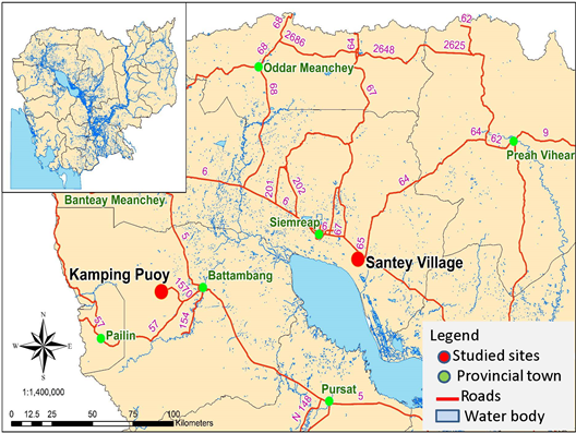
This paper takes the conceptual discussion above to analyze water security in Cambodia. Water security such as floods and drought has long been issues in many parts of Cambodia. It is beyond the scope of this study to understand water security across the entire country. Rather, the study focuses on areas where critical water issues, particularly the problem of too much or too little water, are affecting the livelihood security of rural communities and risk impairing the functioning and sustainability of ecosystem services. Thus, the Tonle Sap region was selected for study. The Tonle Sap region is located in the center of Cambodia, covers six provinces and is home to about 4 million people. It is likened to the heart of Cambodia, with the Mekong River flowing in and out of the Tonle Sap Lake, supporting fishery productivity and rice farming [33].
Siem Reap is one of six provinces of the Tonle Sap Lake, where a large portion of Siem Reap’s southern border is demarcated by the Tonle Sap Lake. In modern times the province is best known as the site of Angkor and the Angkor Wat temple ruins, where ancient water management during the Angkor Empire was remarkable and some of these practices remain practical in some Khmer communities at the present time. Santey is one of 875 villages in Siem Reap Province located in the Tonle Sap floodplain. This village is selected for this study given its uniqueness of indigenous water management practice that takes roots from the ancient time [34]. It is worth to examine why this community still practice the Metuk water management system, while many communities across the country adopts the FWUC approach (farmer water user communities) to manage water (Figure 1).
This study largely relies on both primary and secondary data. Secondary data was collected from various archive sources at national, provincial and local levels. Primary data was collected from semi-structured interviews held with stakeholders at the national and community levels, as well as focus group discussions (FGDs) held in Santey village in Siem Reap Province. This community was selected for an in- depth study into water management and governance based on the availability of relevant information and data on water management interventions.
The study interviewed 18 people from UNDP, ADB, NGOs and government agencies at the national level. Some 45 interviews were conducted at the community level. These interviews focused on water management, as well as the policies and legal framework in place to support such activities, the capacity of each community to address water management, the level of participation among local communities and stakeholders, and the challenges and opportunities that exist to improving water management in the relevant areas. Two focus group discussions were conducted, with 7-9 people participating in each group, including members of Commune Councils, village chiefs and Metuk committee. These discussions focused on roles and responsibilities played by Metuk committee, as well as the management and use of water, the contributions made by members, the collection of water fees, competition and conflict that occurred, and also areas for improvement.
Both qualitative and quantitative analytical approaches were used to analyze the collected primary and secondary data. Since the sample size was small, the researcher used Excel to analyze quantitative data. The data was entered into Excel sheets and processed into percentages, Figure and a Table. Percentage, fact and Figure were supported by qualitative information. The qualitative information and data were analyzed based on the results of the FGDs.
Improving water management is key to address water security, not too-much and not too-little water. On the one hand, it concerns the capacity of societies and ecosystems to respond to water insecurities faced by society and ecosystem in terms of variations in either quantity or quality of water as well as water related disasters through building infrastructure and investing in technology to make water available and accessible for health, livelihoods, ecosystem, and productive economies. On the other hand, it is the capacity of the societies and ecosystems to adapt and resilience to the changing water quantity and quality, and safe uses (Sustainable Water Partnership, note date). In addition, according to Jepson W, et al. [11], water security is about “ securing the ability to engage with and benefit from the sustainable hydro-social process that support water flows, water quality, and water services in supports of human capacities and well-being [11].
Results and Discussion
Water security in the forms of floods and drought has occurred in Cambodia since immemorial times. Efforts have made since the past to address water security and to protect Cambodia from being affected by flood and drought. At present, the treats from water remain challenges and keep the state awake to prepare for the severe floods and drought. The following section discusses the past and the present coping mechanism of Cambodia to address water security.
Ancient Water Security Practices
Flood and drought had threatened the Khmer kingdom since the ancient time, and water management has been a primary concern for the Khmer people. The Angkor Kingdom, started in 802, began to address water security as a central to the development of Angkor. During the Angkor period (9th - 14th Century), the Khmer Kings built the channels and reservoirs to collect and store water coming from the upper plain [35]. Moore [36] demonstrates that Khmer’s water management is related to the uses of water for defence and for religious purposes as well as for irrigation and flood control [36]. A system of overflows and bypasses carried surplus water to the Tonle Sap Lake. The Angkor Kingdom manages floods and drought successfully and the Angkor was named after its success as the “hydraulic city of Angkor” [35, 36].
According to Moore [36], there are two types of water management structures:
- Irregular system and
- Rectilinear system. On the one hand, Moore [36] discusses the irregular system of water management by examining the moated village of Lovea, located about 6km north-west of Angkor site, on slopes north of the Tonle Sap Lake, with 12m wide earthwork and 30m wide moat surrounded the village. The earthwork and the moats were not systematically excavated, but the earthwork follows the contour of the terrain forming a perfect circle, reflecting the natural environment out there, which in overall, offer agricultural, defense, and most probably religious benefits. On the other hand, Moore [36] discusses the rectilinear water management system by looking at the Kok Chan Barray, West barray, and Bateay Sras of Angkor. Two types of rectilinear system:
- Moat is surrounded by rectangular habitation areas, but they are no longer territorial boundaries;
- The settlement domain that is located on the moat areas and barray. The rectangular moats protected the temple and city, within its boundaries of both physically and spiritually.
Rectilinear system of water management can be found in Angkor areas. Kummu [35] studied water management in Angkor and found out that water management during the Angkor period includes the construction of canals to divert water from natural rivers originating in the upper plain (elevation between 28 and 70m AMSL); the barray (reservoirs) to store waters and the drainage system to disperse the water down into Tonle Sap Lake. This water management system was managed by the administration at the city level which was described as the “hydraulic of City of Angkor”. Water management was also undertaken by the sub- city administration, particularly at the community or village level through which the big water pond known as “tropeang” was built and managed to store and supply water to villagers. The “tropeang” is also dug in the temple to store water for many villages surrounding the temple and it is managed by the Buddhist monks. At the household level, every house built a small mound that raises the house above the flood and a small pond [35]. According to Moore [36], “every family a pond, or… several families own one in common” (p.209).
At the city level of Angkor, water management system covered an area of nearly 1,000km2 and served to connect the main city with its extensive villages. Four major baray are found in Angkor today: Indratataka (baray of Lolei), Yasodharatataka (East baray), West baray, and Jayatataka (North baray). Infrastructure of this size (the West Baray, the largest of the rectilinear reservoirs, has an area of 16km2) and complexity is internally interdependent, resistant to change. By the end of the twelfth century it had become a vast and convoluted web of canals, embankments, and reservoirs. From the 12th century onwards, Angkor Wat was built and the empire reached its peaks-the large new channels primarily disposed of water to the lake. Over the next couple of centuries, the system seems to have functioned pretty well as the city continued to flourish [37, 38].
At the regional level of the Tonle Sap, three types of water management systems were identified [39]. First, when flood water submerged the Tonle Sap’s floodplain between May and October each year; additional ponds, canals and moats serving as reservoirs were built to tap the rising water for cultivating the wet season rice and the floating rice. This was referred to as a floodplain water management. Second, in the 18th century, the bunded field system with small bunds or dams across small streams, and ditches or bunds parallel to mainstreams were built to trap receding waters or to store water flowing in from tributaries or adjacent areas by farmers in the rainy season. More than 50 million bunded fields existed in the Angkor period [39]. Third, when flood water receded the Tonle Sap’s floodplain in November-February, bunds, small dams, dykes, ditches, natural moats and swampy areas or in various types of man- made reservoirs in adjacent areas to the lake body were built for the dry season rice and recession rice. After the rainy season, supplementary watering was achieved by gravity from reservoirs or tributaries using ditches and/or simple water lifting devices. Often, rice was grown in the upper parts of reservoirs. Depending on local circumstances, the micro relief with depression, levees and tributaries, a great diversity of sophisticated receding flood farming practices have been developed in the floodplains of Cambodia [39].
In the mid to late 1300s, Angkor began suffering from a persistent drought. The “hydraulic city” of Angkor, the capitol of the Khmer Empire in Cambodia, experienced six years long drought in the fourteenth and fifteenth centuries [38]. The Angkor droughts were of a duration and severity that affected the sprawling city’s water supply and agricultural productivity [36, 39]. The drought was followed by 20 years of unusually strong monsoon rains [38]. These resulted in serious flooding that the city’s infrastructure seemed to have been unable to cope with. The flooding caused serious erosion in the system, with links in it being systematically severed damaged infrastructure and agriculture after the effects of droughts. Angkor and its kingdom were clearly exposed to numerous social, economic, and geopolitical pressures. The water management system may have been insufficient to cope with changing hydrological conditions [35, 38].
Modern Water Security Practices
After Angkor, floods and drought continue to threaten Cambodia. Under the rules of King Sihanouk between 1953-1970, water management was strongly promoted. The Western water management system based on a heavy engineering approach was utilized to manage water in Cambodia, in which large-scale water irrigation schemes and canals were built countrywide by the civil engineering to manage and control water for agriculture. A cascade of large hydropower dams, mainly in combination with irrigation schemes (up to 200 000 ha) was planned in the mainstream and major tributaries of the Mekong and Tonle Sap Lake [40].
Under the Khmer Rouge (1975 - 1979), the entire population was forced to grow rice during the wet season and to construct water management and irrigation systems during the remaining five to eight months of the year. The human forced labors were utilized to construct the irrigation system and canals across the country for rice cultivation and the whole economy was turned into a super irrigation development and became independent of rainfall. As a result, irrigation canals were not laid - out according to contour lines, but on the coordinates. The canals from this period are situated in North - South or in East - West directions having a distance between them of one kilometer. Due to the inclination of the terrain, sections of these canals often slope in different direction than other sections. The forced labors for heavy construction of irrigation schemes using man powers, not machines, resulted in more death due to diseases, famines and killing [41].
At present (1990-2019), water management in Cambodia is driven by a Western engineering approach on the one hand, and the adoption of the irrigation schemes built during the Khmer Rouge on the other hand to manage and control water [42]. Over 2,500 irrigation schemes in Cambodia built during the Khmer Rouge were scrutinized by categorizing into small (50 to 200 ha), medium (200 to 5,000 ha) and large scale (>5,000 ha), of which 47 of them are large-scale, 1,243 medium-scale, and 1,254 small-scale schemes [43]. In terms of irrigated area, this corresponds to an annual total irrigated area of some 498,200 ha for large, 931,900 ha for medium and 131,290 ha for small-scale schemes, giving a total area of over 1,561,390 ha. Of total schemes, about 1926 schemes are in potential for rehabilitation [44]. Since 2000, about $1.3 billion have been invested in water management, of which development partners funded 80% and 20% by national budget. About 467,000 ha of rice farming areas has been irrigated by rehabilitated schemes, of which 327,000 ha for the wet season rice and 140,000 ha for the dry season rice [44, 45].
In overall, the modern water management in Cambodia is characterized by a top-down and sectoral approach; requiring a high technical capacity, high costs and state- driven interventions. Such projects seldom involve public participation in the consultation, decision-making and design processes [46]. Therefore, many large-scale irrigation schemes do not operate in the dry season due to a shortage of water; while many small-scale irrigation systems, such as those suitable for small farmers, have not been built. Hence, the efficient use of water resources continues to be a challenge to Cambodian farmers and water remains a key security to livelihoods, farming, and development [47].
As a result, in some years, the abundant water resources exceed the absorptive capacity of the country and the river system, causing more flooding. Flooding has occurred eventually every year. Flooding in 2000 killed 350 people and caused US$150 million’s worth of damage to crops and infrastructure [48]. In 2011, floods affected 350,000 households (over 1.5 million people) and 52,000 households were evacuated. Out of 24 provinces, 18 were affected; four provinces along Mekong River and Tonle Sap had the most damage. The death toll reached 250, and 23 people sustained injuries from the floods in 2011. Nearly 431,000 hectares (1,065,000 acres) of transplanted rice fields were affected and 267,000 hectares (659,770 acres) of rice fields were damaged. In addition, 925 kilometers (575 miles) of the national, provincial, and urban roads were affected and 360 kilometers (225 miles) of the roads were damaged. The 2011 floods caused an estimated loss at 630 million USD [49].
In 2013, floods affected 20 out of 24 provinces, 377,354 households, claimed 168 lives, and forced 31,314 households to evacuate to safe areas. A heavy flood occurred in 2013 that killed 184 people and made economic loss of $525 million, of which it damaged agriculture estimated at about $150 million. Compared to floods in 2011, floods in 2013 appear to have been less extensive in scale, although in some provinces the impact, including number of evacuated families, damaged crops, and damaged infrastructure, was more significant due to a combination of factors such as: unexpected gravity of the floods, both in extent and intensity, longer time for waters to recede, repeated floods and flash floods, limited preparedness undertaken in advance and limited early warning [49].
El Nino in 2015-2016 weather caused less rainfall, warmer weather and delayed or shorter monsoon rains in Cambodia. The National Committee for Disaster Management’s (NCDM) estimated that at least 50 percent of districts were affected by the drought [48]. During this time, 18 of Cambodia’s 25 provinces were severely affected by drought and 2.5 million people were affected. There was significant crop damage and low water supplies which affected many poor communities who depend on this for irrigation. Health centers reported increased cases of illnesses. Children are vulnerable including diarrhea, fever, and upper respiratory infections [49].
In 2009, 13 out of 24 provinces were affected by severe droughts. There were 57,965 hectares (143,235 acres) of rice crops affected and 2,621 hectares (6477 acres) were destroyed. On 29 September 2009, Cambodia was hit by Typhoon Ketsana. Out of the 25 provinces, 14 were affected by the typhoon, as well as 180,000 households. In addition, 43 people died and 67 were injured. In 2010, 12 provinces out of 24 were affected by severe drought, as well as 14,103 hectares of transplanted rice. In 2011, drought affected 3804 hectares (9400 acres) of rice fields and destroyed 53 hectares (130 acres). In 2012, drought hit 11 out of 24 provinces, affected 14,190 hectare (35,065 acres) of rice fields and destroyed 3151 hectares [49].
Climate change will worsen the floods and droughts; particularly it will induce heavy rains causing more floods and a long drought as followed. Thus, Climate change will induce a water security and Cambodia will be severely affected as a result. Floods accounted for 70% of rice production losses between 1998 and 2002 [49], while droughts accounted for 20% of those losses. Both flood and drought have led to significant food insecurity [50]. The other 10% of losses was due to other causes such as pest and disease outbreaks [51]. However, shortage of water in the dry season is not because Cambodia has no water, but because there is not enough water the country can tap into due to the inability to manage water resources. Thus, effective and appropriate water governance is central to the development of Cambodia.
Case Study of the Metuk Water Management System
The case study of Metuk water management system is undertaken in Santey village. The following discussion focuses on its geography, its people, farming system and water management or Metuk system.
Santey and its People
Santey is located in the floodplain of the Tonle Sap Lake in Danrun commune, Sotr Nikum district, Siem Reap province. Geographically, Santhey as a village has two sub-villages: (i) Santey; and (ii) Kanthou. Santey is a land-based community, located permanently on land, but it is surrounded by water, partly by rain water, and largely by the Tonle Sap’s water. Another sub-village of Santey known as Kanthou is located about 5.5km from Santey and it is about 1.5km from the bank of the Tonle Sap Lake. Kanthou is situated on land for six months and on water for another six months, and houses are built on stilts about 6m above the ground. About two third of farmlands of Santey are fully covered by floods for almost the same period, only one third of farming land is cultivated the wet season rice from May to July. During the wet season (May-October), fish migrates from the Tonle Sap to community ponds and ricefield areas. In the dry season (November-April), flooding recedes from village areas, fish return to the lake and fishing activities begin.
Officially, Santey is home to about 259 families, of which about 167 households live in Santey and 92 households live in Kanthou. Some households have houses in Santey, but only move to stay in Kanthu for fishing and other agricultural activities seasonally, but some own houses only in Kanthou.
The total land area is about 265ha, of which 117 ha is a farmland. About 96 ha of farmlands belong to villagers in Santey and 21 ha to Kanthou’s villagers. About 252 households rely on agriculture for income. Among them, 61 households are engaged in fishing. About 100 families own farming land less than one hectares, 30 families are landless, and the rest has a farmland between one and five hectares (Table 1). Farming is based on rainfall and thus, they depend entirely on weather for farming. Farmers need water for irrigating their ricefield in order for them to do 2-3 crops a year, while fishers intend to keep water for their fish. Farming and fishing are the key livelihoods activities of Santey’s villagers.
| Village | Population | Land | ||
|---|---|---|---|---|
| No. Households | No. Of population | Total land (ha) | Agricultural land (ha) | |
| Santey | 167 | 740 | 145 | 96 |
| Kanthor | 92 | 224 | 120 | 21 |
| Total | 259 | 964 | 265 | 117 |
Table 1: Land and people. Livelihood Activities
Farming is the main livelihood activity of villagers. In doing so, farmers in Santey organize farmlands into three categories: Sreleu, Srekandal, and Srekrom. This classification is based on rising and falling water of the Tonle Sap, the geography of the ricefield, the duration and the levels of floods; types of rice varieties, and the productivity of the ricefield.
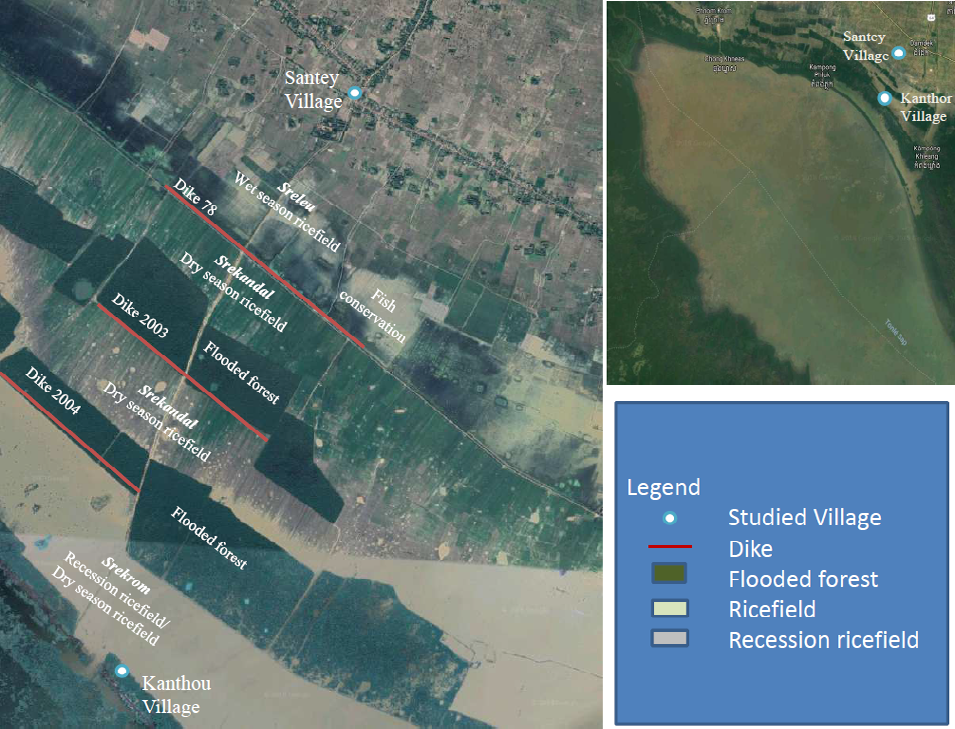
Sreleu (upper field) is located in the upper geographical area of the Tonle Sap floodplain, in an area between 8-10m above sea-level, and in the upper area of Tomnup (Dike) 78, close to Santey village. Agriculturalist expert calls Sreleu a ‘rain-fed lowland rice fields’, which is geographically located in low-lying areas [53]. Farming in Sreleu is very much relied on rainfall. However, the rising water from the Tonle Sap contributes more water for farming in Sreleu in the wet season [53]. One crop a year is cultivated in the sreleu, starting in May, ending in August. Farming in sreleu is a labour-intensive exercise, employing many people, and rice is transplanted.
Srekandal (middle field) is located deeper in the floodplain in the area of 6-8m above sea-level, lower than Sreleu, but higher than Srekrom, about 3km from the village, between Tomnup 78 and Tomnup 2004 [54]. During the high flood, Srekandal is under the water for about 4-5m. Farmers used to cultivate “srove leung tuk” or ‘floating rice’ in Srekandal. This is an indigenous and vernacular difference to the common idea in English of rice that is suitable in conditions of floods. At present, floating rice is not anymore cultivated given the high cost of production and low yields. Nowadays, Srekandal is used for cultivating the dry season rice for 1-2 times a year, dependent on the availability of water. Given the fertile soil, the yield is about 4-5 tons per ha. Between the dike 78 and 2004, there is a flooded forest cover around 124 hectares.
Srekrom means ‘lower field’, located below the Srekandal and the tomnup 2004 (see Figureure 2). This term is used by local people to describe ‘a deep-water rice-field, located close to the Lake, approximately below 6m above sea level [53]. Farmers used to cultivate floating rice in Srekrom. At present, floating rice is no longer practiced, but farmers cultivate the recession and the dry season rice. Actually, when flooding recedes, farmers cultivate recession rice in Srekrom in December and lasts in February. From February to April, farmers start cultivating the dry season rice, using water from the tomnup 2004 to irrigate their ricefields. The rice yield in Srekrom is about 3-4 tons/ha. Rice cultivation in this area is not that intensive, as the area is far from Village. Apart from farming, fishing is a secondary occupation for Santey villagers, but a primary occupation for Kanthou’s households. Flooded forest areas, tomnup (dikes) and sre (ricefields) attract fish to migrate from the lake during the peak flood season and stay for around 4-5 months to feed, breed and survive. Within the area of tomnup 78, there is a fish refuge pond, established by the community to conserve fisheries. Fishing areas around Kanthou is fished by people from Kanthou only, and people from different places. However, large fishing areas around Kanthou and Santey are organized into a fishery community. Two types of fishing take place every year: 1) collecting the fish fingerlings from nature in the wet seasons—cage culture fish; and 2) when water recedes, they transfer the fish to the pond. They dig a pond and put fish in the pond. About 61 households in the Kanthou are engaged in fishing as their primary occupation and the main source of income, using 94 un-motorized and 34 motorized fishing boats, as they live close to the Lake. However, villagers in Santey are engaged in farming as a primary occupation and the main sources of income.
Metuk Water Management System
Despite of a close geographical location to the lake, Santey has so far experienced abundant water resources between May and December, and water shortage between January and April. These have affected rice production and livelihoods of communities. Therefore, villagers have indigenously built the water management system - or Metuk System - to manage the abundance and scarcity of water between wet and dry seasons in harmony with nature for rice production, fishing and other livelihood activities. The Metuk system consists of physical infrastructure and management structure.
The Metuk System is built to tap the rising and falling water from the Lake for rice farming in the sre system (ricefields). It is built based on three different dimensions:
- Geographical zoning of the Sre System;
- Level of water; and
- Seasonality.
Seasonality: Seasonality informs the availability of water. There are two distinct seasons—the wet season and the dry season. The wet season starts in June and ends in October and the dry season starts in November-December and ends in May. During the wet season, there is heavy rain in Cambodia, contributing to the rising water level in the Tonle Sap Lake and dispersing flood water into the floodplains; submerging the Kanthou hut, the flooded forest, and the ricefield for six months of the year. The flood has extended virtually to the center of the Santey village. During the dry season, the floods recede into the Lake, and Kanthou hut starts returning to a normal land-based village, land area is available for cultivation for the rest of the year. Level of Water-Rising and Falling Water: The seasonality determines the level of water. In the wet season, water level in the Lake is rising, leading to rising water level in a Sre system. As a result, the level of water in Sreleu, Srekandal and Srekrom, is rising as well over time and month. The highest water level in the Sre System will be in October-November, and during this period, the Sre system is covered largely by too-much water. Rice farming could only take place in the Sreleu for the wet season rice, while Srekandal and Srekrom are fully covered by water for 3-6m deep. Floating rice was cultivated in Srekandal and Srekrom, but it is not any more practiced.
In the dry season, water recedes from the Sre (ricefields), and the floodplain. Water levels go down gradually. Then, farming and fishing activities commence immediately. Farmers start cultivating the recession rice and dry season rice in Srekadal and Srekrom.
The rising and falling water provides the Santey villagers a Metuk (head of water) to live with for many generations. This Metuk, with a proper management, will benefit villagers to a great extent. However, without a proper management, it will become the enemy of villagers in case of flood and drought. Thus, management of water does not require heavy investment, but needs participation and contribution from villagers.
Geographical Zoning: Water management in Santey is organized into three zones. Each zone is organized into the construction of dike or tomnup. Three tomnup(s) (dikes) have been built by villagers to manage the rising and falling water for irrigation of their sre (ricefields): Tomnup 78, Tomnup 2003 and Tomnup Kseiv (2004). The tomnup systems have been constructed based on indigenous practices of local people, the natural rising and falling water from the Lake, the elevation of the areas and the gravity of water flow. In each tomnup, there are water gates and canals that can be operated by farmers to release water to the sre (ricefield) through canals. Zone 1: Tomnup 78 (Dike 78): The Tomnup 78 was the first tomnup, built during the Khmer Rouge regime in 1978, and so it was named after it, but it was not functional, due to damage and lack of maintenance. In 1988, villagers saw the need of water for rice farming, and hence initiated the rehabilitation program. The tomnup 78 is extended north- south along the bank of the Tonle Sap Lake about 4.5km from the Lake body. The total length of the tonmup 78 under the Santey village management is 1270m, with canal of 5m wide and reservoir of 4m deep in the rainy season and 1.2m in the dry season (Figure.2). It has seven water gates, three are big and four are small. The largest water gate has a size of 1m wide and the small gate has a size of 0.6m. The system has been used since 1988, when head of village started raising funds from villagers to restore the damaged parts. It presently can irrigate about 150 hectares.
In the wet season, when the water level in the Tonle Sap Lake rises up, it flows into the reservoir of the tomnup 78 in late July or early August and then it submerges the tomnup 78 for 3-4 months. At the same time, the heavy rainfall in the upper-land areas of the tomnup 78, contributes to more water flooding the tomnup 78. However, the flood water from the Lake does not reach Santey village. No major activity is taking place in this area, and some fishing activities are carried out, but in small-scale.
In October every year, the flood water recedes from the areas of the tomnup 78. The reservoir of the tomnup 78 retains water for multi-purpose uses. In later November and early December, farmers start cultivating the dry season rice that lasts for three months, and they continue to do the dry season river 1-2 times a year, depending on water availability. Due to natural conditions, farmers use the IR36 rice variety for dry-season rice cultivation in the Srekandal, which it yields 5 tons per ha. About 83 households have farmlands below the tomnup 78 and rely on water from the tomnup 78 for irrigation.
Zone 2: Tomnup 2003(Dike 2003): The tomnup 2003 system was built in 2003 by Santey’s villagers who have farmlands (sre) located below the tomnup 2003 and then named this tomnup after the year of construction. The purpose of building the tomnup 2003 is to secure water for rice farming over these farmlands (sre), particularly in the dry season. About 103 households own 92 hectares of farmlands located below the tomnup 2003 (Figure 2).
The tomnup 2003 has a potential to irrigate a total area of 1150m in length and 800m in width below the dike. The height of the dike is about 2.5m, which creates a huge reservoir that can store a large volume of water. The depth of the reservoir is about 3-4m in December-January, but it goes down to 1-2m in January-March. The reservoir has four water gates, and the size of each gate is about 0.6m wide, helping to store and release water to farmlands for 2 crops a year.
The rice field below the tomnup 2003 falls in the category of Srekandal. From June each year, the water level in the Tonle Sap Lake rises up gradually and it reaches the entire areas of Srekandal in July. Later on in the year, the tomnup 2003 area is completely underwater for a depth of about 4-5m. Flood water stays in this area for four months and it reaches the peak level in October. In the past, this area was used by farmers to cultivate floating rice, started in July to October. At present, floating rice is no longer cultivated and hence, no major activity is carried out, except fishing. However, access to this area is only possible by boat.
In November, flood water recedes from the areas and the tomnup 2003 starts retaining water. Farmers start cultivating the dry-season rice in December, using the short-term rice variety that could be harvested within months, and they rely on tomnup 2003 water to farm the dry-season rice. Fishing activity is taking place also around the Tomnup 2003.
Zone 3: Tomnup 2004 (Tomnup Ksiev): The tomnup 2004 was built in 2004 with villager funds raised locally from ricefield owners whose ricefields are located below the tomnup 2004, following the benefits from the tomnup 78 and the tomnup 2003. The tomnup 2004 has a total length of 1100m and 400m of width. The height of the dike is about 2.5m and the reservoir is 3m deep in the early dry season and 1.2m deep in the late dry season. It has four water gates that help storing and releasing water. Importantly, it has a total capacity to irrigate 44 hectares for 2 crops a year.
In June, water level in the Tonle Sap Lake rises up and it starts submerging the areas below the tomnup 2004. In October, the water level around the tomnup 2004 area reaches the highest level about 5-6m and it submerges the tomnup 2004 areas for four months (June-October). No major activity is carried out, except fishing, but fishing is not productive given the high water level. In December, the flood starts receding and the area turns to be the farmland. About 66 households own farmland in the tomnup 2004.
Block system: In order to manage the tomnup(s) and distribute water effectively and efficiently. Each zone is organized into blocks. The entire Metuk system (tomnup 78, 2003 and 2004) is organized into 8 blocks. The zone one is organized into 3 blocks; the Zone 2 is also organized into 3 blocks and the Zone 3 into 2 blocks.
In each block, there is one canal running straight from the dike (tomnup) into the ricefield. Totally, there are 8 canals built to channel water from the tomnup(s) to the ricefield. In each canal, at least there are three sub-canals that enable water to flow from the reservoir to the canals, to the sub-canals and to the ricefields. Thus, in each block, there are branches of sub-canals. The sub-canal is organized via gravity.
Blocking system enable the Metuk (head of water) to manage water, to release water, and to monitor water availability more effectively and effeciciently. Each block is assigned to one Metuk, responsible for all tasks-fixing the dikes, closing the water gates to keep water in the dikes, releasing water to ricefields, and making sure canals rehabilitated.
The Management Committee, Benefits Sharing and Challenges
The Metuk System is managed by the Metuk committee. The committee comprise of me-tomnup (chief of dike). The chief of dike (me-tomnup) is elected by villagers to manage each tomnup (dike). The election has been undertaking since 1988, following the completion of the rehabilitation of tomnup 78. Following the construction of tomnup 2003 and tomnup Khiev (2004), each tomnup has elected each me-tomnup. The election is taking place annually to recruit the champion (me-tomnup) who has skills, experiences, and technical capacity to manage each dike (tomnup) effectively and efficiently. Election is organized by the village Chief before the dry season rice started; most likely in October every year. Each me-tomnup has three members: one dike chief and two members. However, tomnup Khiev (2004) has recruited only two people—one chief and one member, given the small size of farmland and the low productivity of rice farming.
Generally, as always, me-tonmup is recruited among skillful and experienced farmers within the village, who have experience in water management and benefit sharing, regardless of their educations and age. Young farmers who have no experiences in Metuk management could still have a chance to learn more from the Metuk system and me-tomnup before they stand for election. However, villagers express that young and new me-tomnup can be selected if they are a relative of an old me-tomnup(s). For instance, Lai Lo, as a farmer, was elected because he is a son of an old me-tomnup even if he had no experience in water management. Villagers trust that the Metuk management is not about individuals, but about the family’s capacity and experience that could be passed on to next generation to continue their skills, expertise, and experience.
Each me-tomnup is elected to take at least three-month works to manage the tomnup (dike), its maintenance, the open and close of the water gates, the release of water to sre (ricefield) and to make sure that water from the tomnup is distributed and flown to the remote sre (ricefield). During three months, me-tomnup and his team members work in group and require completing key tasks as following:
The roles of me-tomnup(s) are to monitor their tomnup(s) on daily basis and to make sure that their tomnup(s) are in a good condition. If it is damaged, or broken, they raise funds from villagers to repair it. After checking and monitoring of tomnup(s), they provide information to farmers at least one or two weeks before they open the water gates to release water. Normally, it takes 5 to 14 days to complete the release of water. While they release water into rice fields (sre), the me-tomnup(s) has to be more active in water sharing and to ensure that there is enough water in each rice field (sre). The me-tomnup expresses that sometimes they work until night times to ensue water is released and reaches the ricefield. During a three-month periods, me-tomnup (s) and his crews stay at the tomnup sites day and night to guard the sites and to make sure that water reaches the fields. If water could not flow fast, they have to use their own machines to push water without payments from farmers. They did like that due to their responsibilities and accountabilities to the owners of rice fields.
After completing the release of water, me-tomnup(s) and his crews walk around ricefields (sre) to monitor whether there is enough water in each ricefields (sre). In case rice fields have not received enough water, me-tomnup has to release more water into sub-canals to allow rice field owners to use their personal machines to pump water into their ricefields. Additionally, if any fields get damaged, me- tomnup(s) have to fix the tomnup (s) (dikes) as they can.
Being a me-tomnup brings social status and respect from villagers, given the skills, experiences, capacity and services that this person provides for the villagers’s prosperity. Many villagers intend to be a me-tomnup(s), but many cannot be. In return, me-tomnup gain benefits from villagers. First, the me-tomnup is also a farmer. Being a me-tomnup, he receives a special previledge, in which he/she gets to use water to irrigate their farmland for free.
Secondly, me-tomnup(s) receive compensation from farmers for their work to manage water, maintenance of the tomnup(s), the opening and closing of water gates to release and store the water for farming. The compensation takes the forms of sharing rice yields in the proportion of the total areas of rice fields (sre). After harvesting, each farmer contributes 150kg of paddy rice per hectares to Metuk. However, it depends on the yield each farmer will obtain from their ricefield, and thus, they also negotiate in case their rice yields in that year are not high.
Another sources of income for the Metuk committee members is from harvesting fisheries from the reservoirs inside tomnup 78 and tomnup 2003. After they release water from each tomnup completely, they start harvesting fish in each reservoirs. The fish harvested is sold to fish traders and income from selling fish is utilized to support me-tomnup(s). The remaining income from fishing is used to finance the fixing of tomnup(s), the construction of roads and other infrastructure.
Even though the water management process is being improved - with inefficient and ineffective water distribution being addressed - challenges still exist. The tomnup 78 is getting old and thus, it needs intensive maintenance, but villagers have limited financial capacity to overcome it, although gradually they have been raising funds from rice field owners in Zone 1 in Tomnup 78 to fix some of the damaged areas.
Water from Tonle Sap Lake is very important for irrigation of the dry season rice in all zones. However, the rising and falling water contribute to eventual destruction of all tomnup (s), and thus, it will need an intensive care annually from villagers and the me-tomnup. Hence, funds have been raised annually for the maintenance of these tomnup(s) and villagers have contributed significant amounts of cash for the maintenance. Sometimes, some farmers are not happy to contribute their money to restore the Metuk system and tomnup, even though they know it is useful for them. At the same time, some farmers do not maintain and manage their rice fields well and thus, their ricefields get flooded, while other ricefields do not get enough water, creating the tension among them, questioning the me-tomnup of nepotism and so on.
In the last 10 years, me-tomnup has lacked the water- sharing mechanism, given the fact they did not share the roles and responsibilities among members of the tomnup(s). The other reasons were that they released water from each tomnup at the same time, and so, some rice fields got more water while others got less water. In addition, the water sharing process was not clearly set and therefore, those fields located close to the tomnup (s) got more water than those field far aparts from the tomnup (s). At the same time, canals and sub-canals were not well-developed and thus, water was not well-distributed to all ricefields (sre).
Conclusion
Cambodia has abundant water resources in the wet season and a scarcity of water in the dry season. This overabundance of water in the wet season often leads to flooding, which then damage crops, properties and livelihoods of those living in rural communities throughout the country.
Conversely, in the dry season the lack of water leads to a drought across a large part of the country, damaging crops and rice farming. Thus, effective water management is key to the development of Cambodia as it attempts to manage its floods and droughts, as this will contribute toward improving agricultural productivity across the country.
Water management as a whole falls within the remit of the Cambodian state, which has an important role to play in that regard. Large-scale irrigation schemes dominate the water management sector in Cambodia, but such schemes are expensive, plus they tend to suffer from a shortage of water during the dry season. Some of irrigation schemes date back to the Angkorian period [47], while many were conceived under the Khmer Rouge regime during the latter half of the 1970s. Most schemes were not designed to cope in a context of increasing water scarcity in the dry season and water abundance in the wet season. Most schemes were originally designed and built to provide wet-season supplementary irrigation only [53]. As a result, these schemes do not retain enough water during the wet season for its use in the dry season [46]. Flawed designs in relation to hydrological and geographical realities have also contributed to several existing schemes failures. As a consequence, only 35% of Cambodian farm households produce a paddy rice surplus and the rest produce less than required or just enough for their own consumption [38]. The construction of large-scale irrigation schemes relies on donors and external funding support, but the design and implementation of these projects have conditions attached – such as the ADB irrigation schemes – and are driven by engineering and economic concerns. The ADB and sectoral agencies prefer large-scale infrastructure projects, as they involve million dollars and require both international and domestic expertise.
This case study provides lessons learnt on water management in Cambodia, based on indigenous water management of Metuk system [46]. Metuk is localized, traditional, small-scale and hydro-environmental based system for water management. It is a collective community initiative developed based on the geography of the community, its resources, knowledge, capacity and experience to address water management. The Metuk system is organized through zoning of the areas, level of rising and falling water, and the seasonality of farming. The Metuk system is similar to the practice of water management in Angkor which was studied by Kummu [35], in which zoning and leveling was a core dimension to water collection, reservoir storage and distribution. The Metuk system is built by local villagers, using their own resources and labors, with little hands of government agency involvement, among which Village Chief is the key representative of government agencies involved in overseeing the management, election and fee collection. The system is environmental and user friendly practice. It is utilized to address the current water management problems with a participation of local communities.
The Metuk water management is operated based on the rising and falling water of the Tonle Sap Lake; the zoning and the blocking system of the rising and falling water into a zone 1, zone 2, and zone 3; and the territorialization of a ricefield area based on an elevation into a Sreleu, Srekandal and srekrom. In each zone, the tomnup and prolay system (dike and canal) are constructed to store water and distribute it to a rice field: Sreleu, Srekandal & Srekrom, for rice cultivation. Each tomnup is operated by me-tomnup (chief of dike) and his crew to close and open the water gate to store and release water. The me-tomnup is elected by villagers whose ricefields are watered from each tomnup and the election takes place in August every year. The me-tomnup is accountable to the ricefield owners to ensure there is enough water to irrigate their rice. In return, owners of ricefields compensate the me- tomnup(s) for their time, efforts and skills in maintaining the tomnup, the closing and opening up of water gates and the monitoring of water in the fields. The contribution from owners of ricefields to the me-tomnup(s) in terms of paddy rice per hectares of rice cultivating areas provide incentives for me-tomnup(s) to take accountability to rice farmers. In addition to that, the smaller level of involvement of government agencies from the top to bottom gives local communities a strong ownership over the decision-making, the implementation, the participation and the contribution to the water management. In this regard, the government agencies will not need to do everything for farmers, but farmers know what to do for themselves. Thus, local practice is available for the model for water management locally.
References
-
Rogers P, Alan WH (2003) Effective Water Governance. TEC Background Papers. Global Water Partnership/ Swedish International Development Agency: Stockholm, Sweden 7: 1-48.
-
Pahl Wostl C, Holtz G, Kastens B, Knieper C (2010) Analyzing complex water governance regimes: The management and transition framework. Environ Sci Policy 13(77): 571-581.
-
Ministry of Water Resources and Meteorology (MOWRAM) (2008) Master Plan of Water Resources Development in Cambodia. Report of Republic of Korea; Korea International Cooperation Agency: Phnom Penh, Cambodia.
-
Sithirith M (2017) Water Governance in Cambodia: From Centralized Water Governance to Farmer Water User Community. Resources 6(3): 44.
-
Royal Government of Cambodia (RGC) (2014) Strategy for Agriculture and Water (SAW), 2010-2013. Ministry of Agriculture, Forestry and Fisher4ies: Phnom Penh, Cambodia.
-
Ministry of Water Resources and Meteorology (MoWRAM) (2012) Climate Change Strategic Plan for Water Resources and Meteorology (2013–2017). MoWRAM: Phnom Penh, Cambodia, pp: 1-44.
-
Kummu M, Sarkkula J (2008) Impact of the Mekong River flow alteration on the Tonle Sap flood pulse. Journal of the Human Environment 37(3): 185-192.
-
Kummu K, Sarkkula J, Koponen J, Nikula J (2006) Ecosystem Management of the Tonle Sap Lake: An Integrated Modelling Approach. Water Resources Development 22(3): 497-519.
-
Sithirith M (2015) Tonle Sap Lake, Cambodia: A perspective on its Transborder Hydrological and Resources Governance. Lake and Reservoir: Research and Management 20(3): 187-205.
-
Sithirith M (2014) The patron-client system and its effect on resources management in Cambodia: A case in the Tonle Sap Lake. Asian Politics and Policy 6(4): 595-609.
-
Jepson W, Budds J, Eichelberger L, Harris L, Norman E, et al. (2017) Advancing human capabilities for water security: A relational approach. Water Security 1: 46-52.
-
Grey D, Sadoff CW (2007) Sink or Swim? Water security for growth and development. Water Policy 9(6): 545- 571.
-
Varis O, Keskinen M, Kummu M (2017) Four dimensions of water security with a case of the indirect role of water in global food security. Water Security 1: 36-45.
-
Srinivasan V, Konar M, Sivapalan MA (2017) dynamic framework for water security. Water Security 1: 12-20.
-
Falkenmark M, Lundqvist J, Widstrand C (2006) Macro-scale water scarcity requires micro-scale approaches: Aspects of vulnerability in semi-arid development. Journal of Water Resour Plan Manage 13(4): 258-267.
-
Raskin P, Gleick P, Kirshen P, Pontius G, Strzepek K (1997) Comprehensive Assessment of the Freshwater Resources of the World. Water Futures: Assessment of Long-range Patterns and Problems Stockholm, Sweden, pp: 1-58.
-
Seckler D, Barker R, Amarasinghe U (1999) Water scarcity in the twenty-first century. Int J Water Resour Dev 15(1-2): 29-42.
-
Sullivan C (2002) Calculating a Water Poverty Index. World Dev 30(7): 1195- 1210.
-
Sithirith M, Evers J, Gupta J (2016) Damming the Mekong tributaries: water security and the MRC 1995 Agreement. Water Policy 18(6): 1420-1435.
-
Falkenmark, M (1986) Fresh water as a factor in strategic policy and action. In: Westing AH, et al. (Eds.), Global Re- sources and International Conflict, Oxford University Press, Oxford, UK, pp: 85-113.
-
Homer Dixon T (1994) Environmental Scarcities and Violent Conflict. International Security 19(1): 5-40.
-
Gleditsch NP, Furlong K, Hegre H, Lacina B, Owen T (2006) Conflicts over Shared Rivers: Resource Scarcity or Fuzzy Boundaries? Political Geography 25(4): 361- 382.
-
Savenije HH, van der Zaag P (2002) Water as an Economic Good and Demand Management: Paradigms with Pitfalls. Water Int 27(1): 98-104.
-
Sustainable Water Partnership (2019) What is Water Security? USAIDs.
-
Krause F (2016) One Man’s Flood Defense Is Another Man’s Flood”: relating through water flows in Gloucestershire, England. Soc Nat Resour 29(6): 681- 695.
-
Kreibich H, Thieken AH (2009) Coping with floods in the city of Dresden, Germany. Nat Hazards 51: 423-436.
-
VanKoningsveld M, Mulder JPM, Stive MJF, VanDerValk L, VanDerWeck AW (2008) Living with sea-level rise and climate change: a case study of the Netherlands. J Coastal Res 242: 367-379.
-
Chen Y, Syvitski JPM, Gao S, Overeem I, Kettner AJ (2012) Socio-economic impacts on flooding: a 4000-year history of the yellow river, China. Ambio 41: 682-698.
-
Barendrecht MH, Viglione A, Bloschl GA (2017) dynamic framework for flood risk. Water Security 1: 3-11.
-
Di Baldassarre G, Martinez F, Kalantari Z, Viglione A (2016) Drought and flood in the anthropocene: Modelling feedback mechanisms. Earth Syst Dyn Discuss, pp: 1-24.
-
Elshafei Y, Coletti JZ, Sivapalan M, Hipsey MR (2015) A model of the socio-hydrologic dynamics in a semiarid catchment: isolating feedbacks in the coupled human- hydrology system. Water Resour Res 51(8): 6442-6471.
-
van Emmerik THM, Li Z, Sivapalan M, Pande S, Kandasamy J, et al. (2014) Socio-hydrologic modeling to understand and mediate the competition for water between agriculture development and environmental health: murrumbidgee River basin, Australia. Hydrol Earth Syst Sci 18(10): 4239-4259.
-
Stevens S (2001) Fieldwork as commitment. Geogr Rev 91(1/2): 66-73.
-
National Institute of Statistics (NIS) (2011) Economic Census of Cambodia 2011: Provincial Report 17 Siem Reap Province. Ministry of Planning, Phnom Penh, Cambodia, pp: 1-184.
-
Kummu M (2009) Water management in Angkor: Human impacts on hydrology and sediment transportation. Journal of Environmental Management 90(3): 1413- 1421.
-
Moore E (1989) Water Management in Early Cambodia: Evidence from Aerial Photography. The Geographical Journal 155(2): 204-214.
-
Fletcher R, Penny D, Evans D, Pottier C, Barbetti M, et al. (2008) The water management network of Angkor, Cambodia. Antiquity 82(317): 658-670.
-
Buckley BM, Anchukaitis KJ, Penny D, Fletcher R, Cook ER, et al. (2010) Climate as a contributing factor in the demise of Angkor, Cambodia. PNAS 107(15): 6748- 6752.
-
Sinath C (2019) Investment in land and water management in Cambodia. FAO.
-
Khun A (2012) King Sihanouk, an Artist and Architect of Cambodia. NPR.
-
Kiernan B (1993) Genocide and Democracy in Cambodia: The Khmer Rouge. The United Nations, and the International Community, New Haven: Yale University Southeast Asia Council, pp: 335.
-
Ojendal J (200) Sharing the Good: Modes of Managing Water Resources in the Lower Mekong River Basin. Goteborg University Department of Peace and Development Research: Goteborg, Sweden.
-
Royal Government of Cambodia (RGC) (2014) National Strategic Development Plan 2014-2018: Growth, Employment, Equity and Efficiency to Reach the Status of an Upper-Middle Income Country, Phnom Penh, pp: 268.
-
Ministry of Water Resources and Meteorology (MOWRAM), Agence France Development (AFD) (2018) Water Resources Management and Agro-ecological Transition for Cambodia. WAT4CAM Phase 1, Program Feasibility Study: Final report, SCP in Collaboration with GRET, Phnom Penh.
-
Ministry of Water Resources and Meteorology (MOWRAM) (2019) Draft National Irrigation and Water Resources Management Investment Program 2019- 2033. Phnom Penh, Cambodia.
-
Asian Development Bank (ADB) (2019) Presentation of Draft National Irrigation and Water Resources Management Investment Program 2019-2033 at the National Workshop on 13 February 2019. MOWRAM, Phnom Penh, Cambodia.
-
Cambodian Development Research Institute (CDRI) (2010) Empirical Evidence of Irrigation Management in the Tonle Sap Basin: Issues and Challenges. Phnom Penh, Cambodia, pp: 1-56.
-
Chea C (2010) The Local Governance of Common Pool Resources: The Case of Irrigation Water in Cambodia. Cambodian Development Research Institute (CDRI), Phnom Penh, Cambodia.
-
National Committee for Disaster Management (NCDM) (2002) Disaster Management in Cambodia. Phnom Penh, Cambodia.
-
Mekong River Commission (MRC) (2011) Flood Situation Report 2011. Mekong River Commission (MRC), Vientiane, Laos.
-
Royal Government of Cambodia (RGC) (2006) National Adaptation Program of Action to Climate Change (NAPA). Phnom Penh, Cambodia, pp: 1-125.
-
Cambodia Water Partnership (2010) The State of Climate Change Management in Cambodia. Phnom Penh, Cambodia.
-
Keskinen M (2003) Socio-economic survey of the Tonle Sap Lake, Cambodia. Master thesis, Helsinki University of Technology, Helsinki, Finland.
-
Chea C, Nang P, Khiev D, Hirsch P, Whitehead I (2011) Improving the Governance of Water Resources in Cambodia: A Stakeholder Analysis-Understanding Stakeholders’ Roles, Perceptions and Constraints for Effective Irrigation and Catchment Management and Development. Cambodia Development Research Institute (CDRI), Phnom Penh, Cambodia, pp: 1-78.
- Lessons to Learn: Trees are More than the Lungs of the World
- Community Forestry Enterprises as a Model for Sustainable Forest Development: The Case Of The "Baja Tarahumara" in Chihuahua, Mexico
- Ecological and Socio-Economic Impacts of Chromolaena odorata and Mesosphaerum suaveolens, Two Invasive Alien Species in Central and Southern Benin, West Africa
- Epigenetic Sustainability: Modeling the Human Factor as a Natural Resource through Science 4.0 and the NR3C1 Biological Pilot
- Growth-at-Risk: A Framework for Assessing Economic Vulnerability
- The Rural Territory as a Socioecological System for the Management of Public Policy for Sustainable Rural Development