Remote Sensing Application for Tall Oil Palm Harvester
Oil palm is the primary source of economic gain and the community's primary need for palm oil and other daily necessities. In order to maximise the yield and benefits of oil palm, it is very difficult to do so with ordinary labour, and even if it is possible, it takes a long time to produce. Therefore, by adopting new technology, it is possible to overcome the challenges posed by tall oil palm harvesting. The application of remote sensing on tall oil palms will facilitate the harvesting procedure. With advancements in technology, such as remote sensing, it will be possible to achieve better results in less time and with fewer people. This pole has been equipped with multiple functionalities, such as a camera, to facilitate harvesting. This is because the height of the oil palm prevents workers from seeing the condition of the fruit and fronds that will be dropped. This paper also explains the use of remote sensing and its applications to the monitoring of oil palm plantations.
Introduction
Oil palm, also known as Elaeis guineensis, is a perennial tree that is primarily grown for its oil-rich fruit. The tree is native to tropical regions of Africa but is now widely cultivated in other tropical and subtropical areas around the world, including South and Southeast Asia, Central and South America. The oil palm tree can grow up to 30 meters tall and produces large clusters of fruit that can weigh up to 25kg. The fruit of the oil palm tree contains a high percentage of oil, which is extracted and used in a wide variety of products, including cooking oils, margarine, and biofuels. In addition to its economic importance, tall oil palm is also of significant ecological importance, providing habitat for a wide variety of plant and animal species, particularly in tropical rainforests where it is grown. The plantation of tall oil palm has also been criticized as it is responsible for deforestation and loss of biodiversity in many regions.
The harvesting of fresh fruit bunches (FFB) accounts for roughly 60% of total labour operation and 50% of total workers in the production cost. Oil palms can be challenging to harvest because of their height and because the harvesters must work at a distance from the trees, making it difficult to see the fronds within the fruit bunches. In addition, a sickle on the end of a long pole is employed for tall palms. A sickle’s cutting efficiency is enhanced by its sharpness, form, and profile, all of which come into play as the tool is drawn downwards to accomplish its work. The harvester’s ability is put to the test as he performs tasks including lifting and manipulating the long pole, trimming the fronds and fruit bunches, and reducing waste. Due to this, skilled workers would be unable to produce as much, and harvesting would take much longer.
Remote sensing is a powerful tool that can be used to improve the efficiency and precision of tall oil palm harvesting. The technology allows for the collection of data on the health and maturity of palm trees, as well as the location of fruit clusters, from a distance. This information can then be used to optimize the timing and method of harvesting, resulting in increased yield and reduced costs. Remote sensing application to the pole with various advanced technology functions will make it easier for harvesters to harvest tall palm fruits. Overall, the application of remote sensing in tall oil palm harvesting has the potential to significantly improve the productivity and sustainability of this important crop.
Literature Review
Basic Parts/Tools of Remote Sensing for Tall Oil Palm Harvester
With a broad coverage, remote sensing is atechniquefor timely, reliable, and accurate information about the Earth’s surface. It is an effective way to keep track on the development of oil palms. As shown below, remote sensing can help with decision-making for effective plantation management and can be used to investigate how oil palm plantations affect the environment. Since it became one of the enduring elements on the land for agricultural purposes, the oil palm is an element of interest for remote sensing applications. To monitor land use changes cost-effectively and sustainably, remote sensing has become necessary. On the other hand, several oil palm remote sensing applications are still in the research and development phase. Traditional surveying techniques are used in the current monitoring activities. Additionally, there is insufficient cooperation between academia and industry to advance the sustainability of palm oil. This lack of cooperation may be caused by a lack of knowledge of the methods and sensitive information involved in the industrial side’s successful palm oil production. For remote sensing to be used effectively, the divide between academia and industry must be closed. While exploring the potential of remote sensing in oil palm cultivation, application- focused research using the technique could be profitable for the sector. These studies aim to address or lessen some of the major issues that the oil palm industry is currently dealing with, such as illegal deforestation, the spread of disease or pests, the identification of nutrient deficiencies, yield estimation, palm counting, and the monitoring of oil palm-induced environmental degradation. To enable early detection and ongoing monitoring of these issues, remote sensing is a beneficial technique. The innovation named E-Cutter is an electric scythe technology that has a special generator that is light, saves energy and is capable of picking palm oil fruits and cutting palm oil fronds up to a height of about 40 feet. E-Cutter is a complement to existing oil palm harvesting tools that use manual methods such as harvesting poles or scythes. This innovation is an improvement to the ‘cantas’ technology by replacing the mechanical concept with electricity which is more economical and environmentally friendly based on finding Ahmad H, et al. [1]. The sickle will vibrate to cut the palm fronds or fruit. It is developed through a system that combines an electric generator and a motor. Double Standard Generator which has high power density is used as a generator. It is light and small but high power and is a portable tool for farmers to use. It also has a collection system to minimize injury to the fruit that can affect the quality of the processed oil.
Concepts of Remote Sensing Application for Tall Oil Palm Harvester
Land cover classification: Growing oil palms for their fruit is a huge industry. Learning where oil palms are located is useful in several contexts. The term “land cover” refers to the variety of plants and animals that make up Earth’s surface. Oil palms are easily recognisable as a physical feature on Earth and may be located remotely using sensors. The oil palm can be distinguished from neighbouring forest, buildings, bare ground, water, and other agricultural crops by classifying items according to their land cover classes [2]. It enables precise boundary delineation and area estimates of oil palm plantations. When used in a time series study, it can help find instances of oil palm growth and other land use changes. Optical imaging captures energy reflected from the ground in the visible and near-infrared (NIR) spectrum. Depending on the sensitivity of the sensor, data can be gathered from the sun at various wavelengths across the electromagnetic spectrum (e.g., blue, green, red, red edge, NIR, and infrared band). Spectral intensities are thus altered by the variety of land surfaces. Distinct types of land cover can be recognised by evaluating the reflected energy and sorting it into categories based on their spectral characteristics.
Using a spectral angle mapper, it was determined that the NIR band provides the highest contrast between oil palm crowns and the background Shafri, et al. [3]. The Bhattacharyya Distance was used in a spectral separability test to quantify the best separability classifier. Landsat 7 ETM + red (band 3), near-infrared (band 4), and mid- infrared (band 5) wavelength bands were shown to have the highest distinguish ability between oil palms. Possible causes include high absorption by chlorophyll in the red band and high absorption by water in the infrared band Nooni
et al. [2]. The spectral separability of oil palms from their surrounding land cover is further improved by combining study of these bands by comparing the outcome. Vegetation indices characterise vegetation in terms of its greenness and can be obtained by changing values bands. The Normalized Difference Vegetation Index (NDVI) is a standard measure of plant health that is calculated by comparing near-infrared to red light at the same wavelength.
As a type of active remote sensing, microwaves may generate their own penetrating irradiation and send imagery regardless of the time of day or the weather. Cloud cover is a major obstacle for optical remote sensing, and this was resolved. This was especially helpful in tropical nations where oil palms are commonly cultivated. Using the energy that is reflected from the earth, it can produce useful data. The penetrating power of a microwave increases with its wavelength. Also, by analysing the surrounding pixels, we can learn about the lit target’s texture. This data could be used to differentiate between smooth surfaces like water or dirt and rough ones (like plants or trees) based on their radar wavelength [4]. When the limitations of each source of data are addressed, the combining or fusion of multidimensional data has the potential to provide a more complete picture of the target surface [5].
Change detection: Because of the categorization work done, multi-temporal analysis may now be used to detect changes. To maximise profit, irresponsible forest clearing has occurred to make room for oil palm plantations. There is widespread agreement that the cultivation of oil palms is a major contributor to environmental destruction due to the clearance of forest land, it causes problems in the social order, the carbon cycle, and biodiversity [6]. However, it’s important to highlight that not all oil palm land conversions are unsuitable. If social and environmental considerations are considered, it is even advocated that certain fallow or degraded lands be converted to oil palm to enhance palm oil production. Research into the identification of changes is especially important in the context of oil palm monitoring, where the detection of oil palm expansion and its effects is of paramount importance.
As part of its mission to preserve and protect the world’s natural resources and biodiversity, the Roundtable on the Sustainability of Palm Oil (RSPO) employs remote sensing in change detection to determine whether oil palm plantations were previously converted from high conservation value (HCV) forest RSPO [7]. High Conservation Value (HCV) forests are those that are extremely important on a national, regional, or even global scale due to their biological, social, or cultural significance [8]. Unauthorized land use changes are tracked by remote sensing. Anyone who violates these terms should lose their sustainability certification or face severe financial consequences. Remote sensing services for checking whether a region’s land cover has altered in accordance with the RSPO standard are increasingly being provided by non-governmental organisations (NGOs).
A land cover map is analysed throughout time to see if any areas have been converted to oil palms, and only then is the plan put into action. For this purpose, it is common practise to examine historical records and make comparisons between the “before” and “after” states. Standard remote sensing packages typically include a change detection analysis that may be used to view the transformations. Deforestation, urbanisation, and oil palm plantation expansion can all be revealed through the graphic. Classification based on a single or several data sources yields a land cover map, the precision of which is typically crucial to the success of a change detection strategy. A land cover map is analysed throughout time to see if any areas have been converted to oil palms, and only then is the plan put into action. For this purpose, it is common practise to examine historical records and make comparisons between the “before” and “after” states. Standard remote sensing packages typically include a change detection analysis that may be used to view the transformations. Deforestation, urbanisation and oil palm plantation expansion can all be revealed through the graphic. Classification based on a single or several data sources yields a land cover map, the precision of which is typically crucial to the success of a change detection strategy.
Tree counting: Yield estimation and monitoring, replanting and layout design, etc. all rely heavily on accurate and thorough tree counts. But doing it on a large scale in the field is time-consuming and expensive. Human mistake is a common occurrence. Most plantations just make estimates based on the entire area multiplied by the palms per hectare, which is obviously not true due to the varied topography such as hilly, undulating, or flat and features of the plantation’s location such as river, land, or forest. A solution to this problem is remote sensing, which allows for an automated tree count and a bird’s-eye perspective of the plantation.
Automated tree counting typically makes use of image processing methods including object segmentation, classification, and identification. Choosing a single algorithm or method might be challenging because different studies take different factors into account. The input photos must be of excellent quality, have a high spatial resolution, and have a clear field of view to produce correct findings. Additionally, it’s important to note that this region for tree counting research is an excellent beginning for the introduction of precision agriculture in the oil palm business. To maximise yield while minimising up keep expenses, this method goes above and beyond site- and tree-specific treatment of oil palms. Reduced waste of fertilisers and chemicals like pesticides and herbicides is a bonus, and it also helps with budgeting.
To identify oil palms at the level of individual trees, a very high spatial resolution image is required. To automate the process of tall-tree counting using high-resolution with 1-meter air borne hyper spectral images, a strategy was devised to use several techniques, including texture analysis, edge enhancement, morphology analysis, and blob analysis [3]. Unmanned aerial vehicles (UAVs) are becoming increasingly popular as a means of data collection for tree counting applications since such applications require high- resolution spatial imagery but may not always require a comprehensive survey area [9]. Major plantation firms in Malaysia and Indonesia already routinely employ UAV applications in oil palms, with each company maintaining its own UAV team. A method was created using normalised cross- correlation to identify and exclude non-oil palm components in a study of tree counts based on UAV platform generated data from an oil palm farm in Thailand. Furthermore, template matching, and multi-scale clustering methods are used to distinguish each oil palm from a bush. Automatic tree counting was accurate to within 10% using a digital camera mounted on a remote UAV.
Age estimation: Given that the age of a plant affects both its quality and yield, it can be used as a reliable indicator of yield. Additionally, precision agriculture relies on information about oil palms’ages to identify outliers within a given age group, at which point corrective management methods can be planned for and resource allocation can be optimised. Overall, knowing a tree’s age accurately is crucial for both academic and practical reasons, as it impacts the tree’s output [10]. Because oil palms develop in a specific pattern, this physical characteristic can be used as a proxy for their age. The trunk of an oil palm tree thickens during its first two years of life, and then its height quickly expands after that without any further thickening. The average yearly height growth of a mature palm tree is 30-60 cm, and its trunk diameteris typically 40 cm. When oil palmsare originally planted in a field, their ageis typically documented by giving the field the year in which it was established as normal management practise. Such details, especially those pertaining to the activities of small holders, are unfortunately unavailable to the public and too time-consuming to collect and verify.
The height of an oil palm tree never plateaus. This maturation characteristic is critical for age assessment of oil palms. Throughout its lifetime, an oil palm can grow between 30 and 60 centimetres each year, depending on its environment and genetic makeup. Several types of remote sensing techniques, such as Light Detection and Ranging (LiDAR) and Interferometry Synthetic Aperture Radar (InSAR), can be used to retrieve height information (InSAR). Using just field-measured data, a robust linear association between oil palm height and age has been found. It has been demonstrated that oil palm height may be used as a reliable indication of age. Because oil palm trunks do not thicken after the first two years of growth, the link between age and other biophysical factors like diameter at breast height becomes negligible [11].
Advantages of Remote Sensing for Tall Oil Palm Harvester
- Large area coverage in oil palm. It is because remote sensing allows coverage of very large areas which enables regional surveys on a variety of fruit and identification of the quality of the fruit.
- Remote sensingallows repetitive coverage which comes in handy when collecting data on the harvesting of oil palm
- Remote sensing allows for the easy collection of data over a variety of scales and resolutions to harvest the oil palm.
- A single image captured from the higher oil palm through remote sensing can be analysed and interpreted for use in various applications and purposes.
- Data collected through remote sensing is analysed at the laboratory which minimizes the process of harvesting that needs to be done in the field.
- Increases efficiency – Remote sensing’s capacity to boost productivity is one of its primary benefits. Remote sensing is a useful tool for pin pointing the origin of an issue. Aside from only pinpointing trouble spots, remote sensing can also be utilised to make educated guesses about the future based on the present.
- Provides accurate measurements – Remote sensing has allowed farmers to take precise measurements of a wide range of environmental parameters. They were able to quickly harvest the oil palm thanks to these precise measures. Farmers can utilise remote sensing to keep tabs on how the weather, human activity, and climate change are affecting their crops and livestock.
Limitation of Remote Sensing for Tall Oil Palm Harvester
The inability to accurately assess physical characteristics like temperature, humidity, and wind speed and direction is remote sensing’s biggest drawback. Soil moisture content cannot be directly measured by remote sensing. Realizing the method’s limitations: Its usefulness is often overestimated, which is the largest limitation. Scientific research requires more data than what can be gathered solely through remote sensing. You must pick the right sensors, resolutions, data gathering time, and post-processing procedures for these tools and strategies to work. Expensive method Due to the specialized equipment and expert interpretation needed, remote sensing data is difficult to gather and analyse. Despite this drawback, the technique’s immense rewards are worth the effort.
Research Findings
3D Visual Sensing System and Camera
Remote sensing application is the modern technological elements that can replace growers’ ability during crop cultivation operation, especially in harvesting. For this case study, remote sensing functions are being interconnected with oil palm harvesters. By measuring a region’s reflected and emitted radiation from a distance, remote sensing is the process of identifying and keeping track of its physical features. Researchers can feel things about the earth with the use of special cameras that gather remotely sensed photos. In oil palm cultivation, the remarkable growth of the crop cultivation especially in Malaysia has increase the needs on mechanized harvester, which remote sensing actas the complementary element in successfully operating the mechanized harvester. One of the elements of remote sensing is including a Stereo 3D visual sensing system that designed together with RGB camera that attached to the machinery during oil palm harvesting. It plays important role such as processing the image which containing 3D coordinate of object, which is Fresh Fruit Bunches (FFB). It is helping the harvester to detect the desired grade of FFB by replacing the humans’ eye’s ability to scan on the color or grade, especially when harvesting more than 25 years age of oil palm. Figure 1 illustrates the results on study conducted by Makky [12] on the usage of Stereo 3D camera in oil palm harvesting with the four pair series images from different distances.
![Figure 1: Four pair series of stereo image [12].](/fulltextimages/10019/fig_1.png)
Based on the study, the image has been captured by 3.1 Mega Pixel digital camera and then transferred to IBMPC via Internet connection. It proves that remote sensing can help oil palm harvester to detect on desired grade of FFB where the camera can clearly sense image for maximum 2000 mm distance from the object. When the harvester performs the operation for palm with the age more than 20 years, it is hard if they physically use their own eyes in detecting matured bunches to be harvested. Therefore, the use of 3D stereo visual camera can overcome this issue and the best distance of camera and sensor from the bunches is about 500 to 2000 mm. Table 1 shows the camera calibration in remote sensing. Result of camera calibration for image acquisition using a plain object which has a high contrast to background color, and place with a certain distance from camera lens, while camera move left to right 90mm for stereo image acquisition shall be as table above. The X label is representing the range from object to camera lens. In remote sensing, calculating the center point range of stereo pictures and plotting it on the equation’s output allowed for the measurement of object distances from the camera.
- Object Dimension 161 x 225 mm (36225 mm2)
- Left
- Kanan
- Object Movement
- Position
- X
- Y
- Area (mm2)
- Position
- X
- Y
- Area (mm2)
- Xa
- Xb
- Ya
- Yb
- Xa
- Xb
- Ya
- Yb
- Xa
- Xb
- Ya
- Yb
- Range (mm)
- 70
- 536
- 834
- 408
- 298
- 408
- 121584
- 370
- 666
- 14
- 429
- 296
- 415
- 122840
- 166
- 168
- 14
- 21
- 80
- 545
- 806
- 40
- 406
- 261
- 366
- 95526
- 398
- 659
- 57
- 420
- 261
- 363
- 94743
- 147
- 147
- 17
- 14
- 90
- 548
- 780
- 75
- 402
- 232
- 327
- 75864
- 420
- 653
- 93
- 418
- 233
- 325
- 75725
- 128
- 127
- 18
- 16
- 100
- 550
- 760
- 95
- 389
- 210
- 294
- 61740
- 434
- 645
- 117
- 412
- 211
- 295
- 62245
- 116
- 115
- 22
- 23
- 110
- 551
- 744
- 118
- 385
- 193
- 267
- 51531
- 447
- 639
- 141
- 408
- 192
- 267
- 51264
- 104
- 105
- 23
- 23
- 120
- 555
- 732
- 139
- 383
- 177
- 244
- 43188
- 458
- 634
- 155
- 400
- 176
- 245
- 43120
- 97
- 98
- 16
- 17
- 130
- 557
- 718
- 155
- 381
- 161
- 226
- 36386
- 467
- 629
- 170
- 396
- 162
- 226
- 36612
- 90
- 89
- 15
- 15
- 140
- 559
- 710
- 172
- 381
- 151
- 209
- 31559
- 476
- 626
- 180
- 389
- 150
- 209
- 31350
- 83
- 84
- 8
- 8
- 150
- 560
- 701
- 177
- 373
- 141
- 196
- 27636
- 480
- 621
- 192
- 387
- 141
- 195
- 27495
- 80
- 80
- 15
- 14
- 160
- 562
- 693
- 190
- 373
- 131
- 183
- 23973
- 489
- 620
- 202
- 385
- 131
- 183
- 23973
- 73
- 73
- 12
- 12
- 170
- 563
- 687
- 202
- 373
- 124
- 171
- 21204
- 495
- 619
- 212
- 385
- 124
- 173
- 21452
- 68
- 68
- 10
- 12
- 180
- 565
- 682
- 208
- 371
- 117
- 163
- 19071
- 499
- 617
- 224
- 387
- 118
- 163
- 19234
- 66
- 65
- 16
- 16
- 190
- 566
- 677
- 218
- 373
- 111
- 155
- 17205
- 505
- 617
- 226
- 381
- 112
- 155
- 17360
- 61
- 60
- 8
- 8
- 200
- 566
- 672
- 228
- 375
- 106
- 147
- 15582
- 509
- 615
- 232
- 379
- 106
- 147
- 15582
- 57
- 57
- 4
- 4
- 210
- 564
- 665
- 229
- 369
- 101
- 140
- 14140
- 512
- 613
- 242
- 382
- 101
- 140
- 14140
- 52
- 52
- 13
- 13
- 220
- 564
- 661
- 232
- 365
- 97
- 133
- 12901
- 512
- 609
- 251
- 384
- 97
- 133
- 12901
- 52
- 52
- 19
- 19
- 230
- 569
- 660
- 244
- 371
- 91
- 127
- 11557
- 517
- 609
- 260
- 387
- 92
- 127
- 11684
- 52
- 51
- 16
- 16
- 240
- 569
- 658
- 244
- 367
- 89
- 123
- 10947
- 520
- 609
- 256
- 379
- 89
- 123
- 10947
- 49
- 49
- 12
- 12
- 250
- 571
- 655
- 246
- 365
- 84
- 119
- 9996
- 523
- 608
- 265
- 383
- 85
- 118
- 10030
- 48
- 47
- 19
- 18
Table 1: Camera calibration using plain object [12].
Harvesting Robot
Remote sensing also becoming the element that attached together with the harvesting robot. According to Wan Ismail [13], it has been introduced in year 1992 when UPM students start conducted research on oil palm harvesting machinery. The manipulator, the controller, the power supply, and the end-effector are the basic parts of a robot system. The robotic system’s manipulator performs the mechanical task. A manipulator’s movement is managed by drive systems or actuators. Pneumatic, hydraulic, or electric power can all be used in the drive system. Robot eye is the component of remote sensing which it is involve the camera vision usage. Robot vision research aims to make it possible for robots to replicate human vision in order to comprehend and analyze real-time image sequences. In order to direct the end-effector to the required position and orientation using computer vision or image processing, a vision device is typically attached on the robot. The problem in creating a full vision system that can automatically recognize the color of the item is due to the differences in illumination intensity from time to time and location to place. Figure 2 indicates the concept of oil palm harvesting robot that has been designed by UPM students.
![Figure 2: Conceptual diagram of oil palm harvesting robot [13].](/fulltextimages/10019/fig_2.png)
Based on the study, this mechanization is capable to reduce man power, lighten burden, increase productivity as well as making the harvesting job more interesting than usual. RGB camera is the element of remote sensing that included as the robot eye in identifying desired FFB to be harvested. The image captured then being transferred by using Internet of Things elements. Until now, the initial costs are the only barrier that most farmers are hard to adapt. Therefore, much research has been designed and implemented to tackle the barrier and to add the value to the machine.
Intelligent Colour Vision System
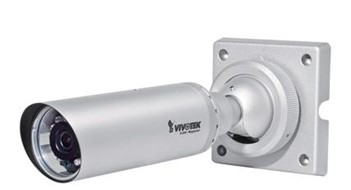
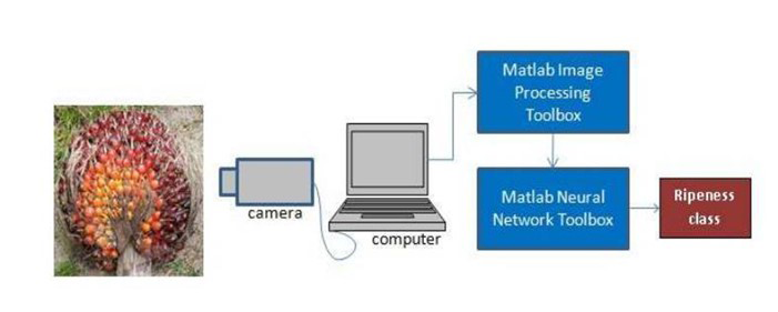
Malaysian Palm Oil Board (MPOB) has established fifteen classes of FFB in the grading of oil palm in palm oil mills such as ripe, underripe, unripe, overripe, empty, rotten, long stalk, unfresh/old, dirty, small, pest damaged, diseased, dura, loose fruit, and wet. Usually most studies only focus on certain grading such as ripe, unripe, and underripe. According to Norasyikin Fadilah [14], intelligent color vision system inspection in assessing every stage in fruit ripeness. The intelligent color vision system consisted of a camerafor image acquisition and a computer for data storage, image pre-processing and ANN classification. The camera type is Vivotek IP8332 Network Bullet Camera where the specifications is 0 lux, 1.0 M pixels, F1.8 (Picture 1) and this camera was chosen due to its ability to adapt to constantly changing outdoor lighting conditions. In Figure 3 shows that the camera was used to acquire the image of oil palm FFB. The images taken from camera will be stored in a computer for the next processing (Figure 4).
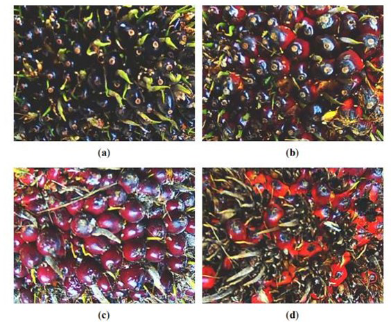
This image will show the different ripeness for each category. Secondly, the images were processed using digital image processing technique to obtain color features of the fruits. Thirdly, after obtained for each image, color features were extracted and appear in computer. And the last, the fruit will be classified for ripeness class of oil palm FFB and ready to harvest it. Four sample images from different ripeness categories are shown in Figure 5 using intelligent color vision system. The unripe fruits are in deep violet to black. As the fruits ripen, they turn red. The overripe oil palm FFB shows that most of the outer fruits are gone, and the inner fruits are orange in color.
Potential Commercialization
Nowadays, oil palm industry seems to be the promising sector that contributing more profits and income to our country. This industry also been referred as the backbone to our country financial. The performance in this sector have monitor and becomes a crucial subject. Moreover, due to the price of the crude oil market price over the globe that rises inexpertly because of the demand on crude oil all over the world. Therefore, many plantations especially in our country focus on produce good and high quantity of their yield and at same time benefit them.
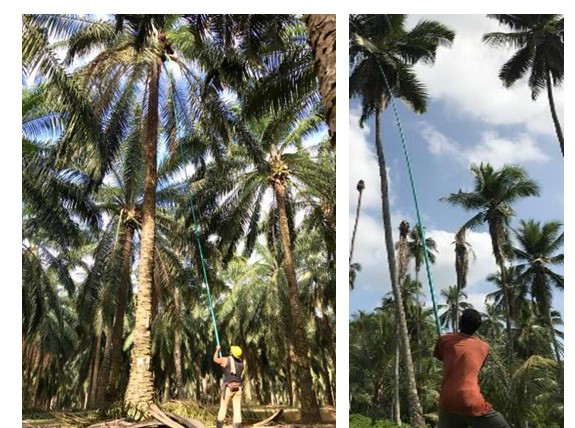
As we know, thee conomical life span of oil palm trees are 25to30 years old. But currently of lifespan the FFB size and weight is at the peak whereas the production of FFB is quite decreasing but still giving the profit to farmers. Harvesting oil palm tree at 25 to 30 years old is quite hard because the height is quite tall which 40 ft. Therefore, many studies and invention were introduced to help saving time and energy such as fibre pole and motorized engine harvester.
Fibre pole
PalmPro Graphite harvesting poles are unique in that they have been custom-built to make life easier for harvesters. Made from incredibly lightweight materials these are nonetheless impressively sturdy. PalmPro ® poles can cut a harvester’s workload in half, enabling them to become more productive than ever. Harvesting fruits from tall palm oil is one of the most common agricultural pursuits, yet it is one that remains a chore for many harvesters to this day. Traditional harvesting poles are notoriously unwieldy and difficult to maneuvers; many poles are not even capable of reaching the heights necessary to collect the best and juiciest fruits without causing strain and potential injury to the harvester (Figure 6).
The main features of this fibre pole are super light, telescopic, durable and last-longer, high stiffness, less slippery, non-conductive pole and repairable. There also several benefits for this pole which are solves the current difficulty of using heavier aluminums poles or bamboo, allow workers to harvest tall oil palms, up to 18m (60ft) easily, boosts productivity by 30% and helps to solve the issue of low harvester number, helps harvesters recover rotten and damaged bunches that went unharvest, shorten the intervals between harvesting and reduces the quantity of loose fruit and all type of harvesting cutter suitable for Palm Pro pole (Figure 7).
Motorized Engine Harvester (Cantas)
The Malaysian Palm Oil Board (MPOB) has developed a motorized cutter popularly known as Cantas™ for harvesting fresh fruit bunches (FFB) at less than 4.5 m height. Cantas™ is a hand-held cutter powered by a 1.3 ph petrol engine. Trials carried out on Cantas™ revealed that the productivity of the machine was 560 to 750 bunches per day (equivalent to 9.50 to 12.61 per day at a bunch weight of 17 kg). The productivity very much depends on the cropping level, the topography of the estate and the operator’s skills. By comparison, the productivity of manual harvesting (using a conventional sickle) is only 250 to 350 bunches per day. Therefore, the productivity of Cantas™ is equivalent to two to three human harvesters. Using Cantas™, the estate would be able to reduce 50% of its labour requirement in the harvesting operation. Another advantage of this cutter is that the terrain or topography of estates does not restrict its usage. Refer to Figure 8, the invention of Cantas™ is not suitable and not long enough to harvest FFB from the palm tree which the height of 30 ft.
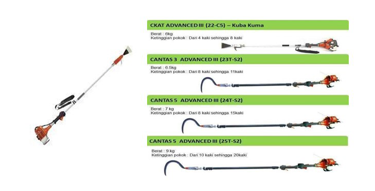
And, above the motorized engine for Cantas™ is parallel to the pole that why it might cause fatigue and tired to the worker to use Cantas™ due to the heaviness of the pole plus the engine.
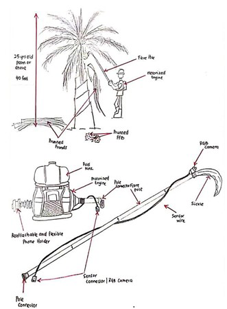
Combination of Fibre Pole and Motorized Engine Backpack
By referring to the studies relating to this futuristic equipment, we had come which an idea of combining these two products to address the harvesting of 25 to 30 years old palm trees. The idea is quite familiar to those products but the improvement of replacing the motorized engine that parallel to the harvester pole into a backpack motorized engine which eases the burden and weight of the harvester tools during the operation (harvesting FFB). As for the pole that attached to the motorized engine to the pole more lighten and long up to 40 ft, which fibre pole from Palm Pro.
Those two combinations will be the relevant and benefits enough to harvest 40 ft palm trees. Those products are quite commercial and high potential in the market especially among the harvesters and farmers. Figure 4 below shown the illustration of the combination of those two products which the label of the features for the new motorized engine harvester tools.
As for the remote sensing, we implemented the RGB camera as the sensor camera to detect the mature FFB that need be harvested. The location of this RGB camera nearly at the tip of the pole because at that position, it will be able to sense bunches that need to be harvested. The info or pictures will be display on the phone through and application software which needed to be installed on the phone first. And for the motorized engine is powered by petrol fuel. The backpack design was to ease the user to carry the tools during harvesting operation because the design is super light with the combination with the fibre pole.
This tool has high commercial potential in the market due to the benefits of this tool. One of the reasons is this tool long enough to harvest 40 ft. Palm tree besides, this tool helps harvester by providing a super light pole to carry during the operation and this tool is repairable which more is encouraged and focused on the smallholders. Meanwhile, the backpack motorized engine that quite like Bush cutter which will also becoming the potential on commercialize this product where the backpack like will be easier to carry (Figure 9).
This tool has high commercial potential in the market because of the benefits of this tool. One of the reasons this tool long enough to harvest 40 ft palm tree. Besides, this tool helps to super light for the harvesters to carry during the operation and this tool is repairable which is more encouraged and focused on the smallholders. Which the back pack motorized engine that quite like Bush cutter will also becoming the potential on commercialize this product where the backpack like will be easier to carry [15, 16, 17, 18, 19, 20].
Conclusion and Recommendation
Oil palm plantation is an unavoidable trend brought on by the population’s increasing desire for less expensive vegetable oil and biofuel. Research efforts should be focused on enhancing industry performance and minimising the harm it does to the environment. When it comes to monitoring the oil palm business from an economic and environmental perspective, remote sensing is a key tool. It is helpful for determining crop quality and environmental conditions. It prepares the sector for the adoption of technology such as machinery automation and precision farming to lower costs, minimize labour dependency, and boost production. The technology had already been adopted by several plantation firms, and some of them even had their own operational professional GIS/remote sensing unit. The use of remote sensing enables businesses to obtain useful information that would otherwise be expensive. Some methods are already in use, but they are kept private or are not published since they are not intended for academic publications. However, to advance in mutual benefit, greater focus should be placed on technique diffusion and information transfer. To give a deeper knowledge, to fill in the gaps, and to share the results with the public, more collaborative research on remote sensing for oil palms is required between professionals from business and academia.
References
-
Ahmad H, Abdul RJ, Johari J, Malik N, Yosri G, et al. (2006) CantasTM-A tool for the Efficient Harvesting of Oil Palm Fresh Fruit Bunches. Journal of Oil Palm Research 20: 548-558.
-
Nooni IK, Duker AA, Duren IV, Addae-Wireko L, Osei EM (2014) Support Vector Machine to Map Oil Palm in a Heterogeneous Environment. International Journal of Remote Sensing 35(13): 4778-4794.
-
Shafri HZM, Hamdan N, Saripan MI (2011) Semi- Automatic Detection and Counting of Oil Palm Trees from High Spatial Resolution Airborne Imagery. International Journal of Remote Sensing 32 (8): 2095-2115.
-
Daliman S, Rahman SA, Bakar SA, Busu I (2014) Segmentation of Oil Palm Area Based on GLCMSVM and NDVI. IEEE TENSYMP 2014-2014 IEEE Region 10 Symposium.
-
Shen H, Wu P, Liu Y, Ai T, Wang Y, Liu X (2013) A Spatial and Temporal Reflectance Fusion Model Considering Sensor Observation Differences. International Journal of Remote Sensing 34 (12): 4367- 4383.
-
Koh LP, Wilcove DS (2008) Is Oil Palm Agriculture Really Destroying Tropical Biodiversity?. Conservation Letters 1(2): 60-64.
-
RSPO (2007) RSPO Principles and Criteria for Sustainable Palm Oil Production. Roundtable on Sustainable Palm Oil, Malaysia.
-
Jennings S, Nussbaum R, Judd N, Evans T, Iacobelli T, et al. (2003) The High Conservation Value Forest Toolkit. 1st (Edn.), Proforest, UK.
-
Hoffmann C, Weise C, Koch T, Pauly K (2016) From UAS Data Acquisition to Actionable Information - How an End-to-End Solution Helps Oil Palm Plantation Operators to Perform a More Sustainable Plantation Management. The International Archives of the Photogrammetry, Remote Sensing and Spatial Information Sciences XLI-B1: 1113-1120.
-
Chemura A, Duren IV, Leeuwen LMV (2015) Determination of the Age of Oil Palm from Crown Projection Area Detected from World View-2 Multispectral Remote Sensing Data: The Case of Ejisu-Juaben District, Ghana. ISPRS Journal of Photogrammetry and Remote Sensing 100: 118-127.
-
Corley RHV, Tinker PBH (2008) The Oil Palm. 4th (Edn.), John Wiley & Sons, USA.
-
Makky M, Herodian S, Subrata M (2019) Design and Technical Test of Visual Sensing System for Palm Oil Harvesting Robot. Proceedings of International Seminar on Advanced Agricultural Engineering and Farm Work Operation Bogor, Indonesia, pp: 582-592.
-
Ismail WWI (2010) Research and Development of Oil Palm Harvester Robot at Universiti Putra Malaysia. International Journal of Engineering and Technology 7(2): 87-94.
-
Fadilah N, Mohamad-Saleh J, Halim ZA, Ibrahim H, Ali SSS (2012) Intelligent Color Vision System for Ripeness Classification of Oil Palm Fresh Fruit Bunch. Sensors 12(10): 14179-14195.
-
Aziz NA (2012) TT No. 502: Remote Sensing Measurement for Detection of Bagworm Infestation in Oil Palm Plantation. Transfer of Technology Malaysian Palm Oil Board.
-
Chong KL, Kanniah KD, Pohl C, Tan KP (2017) A Review of Remote Sensing Applications for Oil Palm Studies. Geo-spatial Information Science 20(2): 184-200.
-
Jelani BR, Hitam A, Jamak J, Noor M, Gono Y, et al. (2016) Cantas TM-A Tool for The Efficient Harvesting of Oil Palm Fresh Fruit Bunches. Journal of Oil Palm Research 20: 548-558.
-
Sharif ZM, Jalil NJ (2019) CantasR A Green Technology for Oil Palm Harvesting and Customer Satisfaction towards Services Quality of CantasR Suppliers in Malaysia. International Journal of Engineering and Technology 8(1.1): 222-227.
-
TenAsia Corporation Sdn Bhd (2009) Palm Oil Harvesting Pole, PalmPro® Graphite-A50 Combination.
-
Alam ASAF, Ah ERC, Begum H (2015) Malaysian Oil Palm Industry: Prospect and problem. Journal of Food Agriculture and Environment 1313(22): 143-148.
- Enhancement of Vegetative Growth and Fruit Yield in Cucumber (Cucumis sativus L.) via Spiritual Blessing (Biofield) Energy Intervention
- Production of Açaí (Euterpe oleracea Mart.) under Different Agroforestry System Management Intensities in Amazonian Floodplain (Varzea) Forests
- Coffee and the Production Region: What is the Secret to the Expression "Quality"?
- Experiential Agripreneurship Training in Sub-Saharan Africa: Integrating a Business Incubator into Postgraduate Livestock Education at the University of Buea
- Advances in Agricultural High-Quality Development
- Linking Compost Residue to ABAGE in Plants - a Short Note