Unmanned Aerial Vehicle (UAV) in Precision Agriculture to Identify the Crop Water Shortage by Using Multi-Spectral Sensor
Accurate diagnosis of crop water shortage and scientific irrigation decisions are crucial. A new method of multi-spectral imaging remote sensing image extraction of tea canopy temperature is proposed, and an automatic processing system of remote sensing thermal imaging images is established. In this short communication, A UAV (Unmanned Aerial Vehicle) with multi-spectral sensors used to capture the images. The research results show that the system can efficiently mosaic images without image gap, and ensure that the soil background is wholly eliminated. This research gives us new methods to set an intelligent method for precision agriculture, which greatly improves the level of agricultural intelligence.
Introduction
As the world population increase, inevitably, the demand for crop production will also increase shortly. Production of the crop in coming years should be targeted to satisfy the world population and grow more than 9.7 billion by 2050 [1]. Tea plants (Camellia Sinensis) are mainly grown in China southwest region with warm, wet, and shaded growing environments [2]. The UAV platform has the characteristics of flexibility, vertical take-off. It can be equipped with infrared thermal imaging sensors to take high-precision infrared thermal imaging at low altitudes. Remote sensing images can be used to obtain the canopy temperature to get the water deficit status of farmland crops and formulate corresponding irrigation strategies. Although intelligent image processing methods have tended to be mature, it is often relatively time-consuming, from image processing to temperature extraction. Currently, the research on image processing mainly relies on applying remote sensing image processing software such as PIX4D, ENVI, and ArcGIS.
Materials and Methods
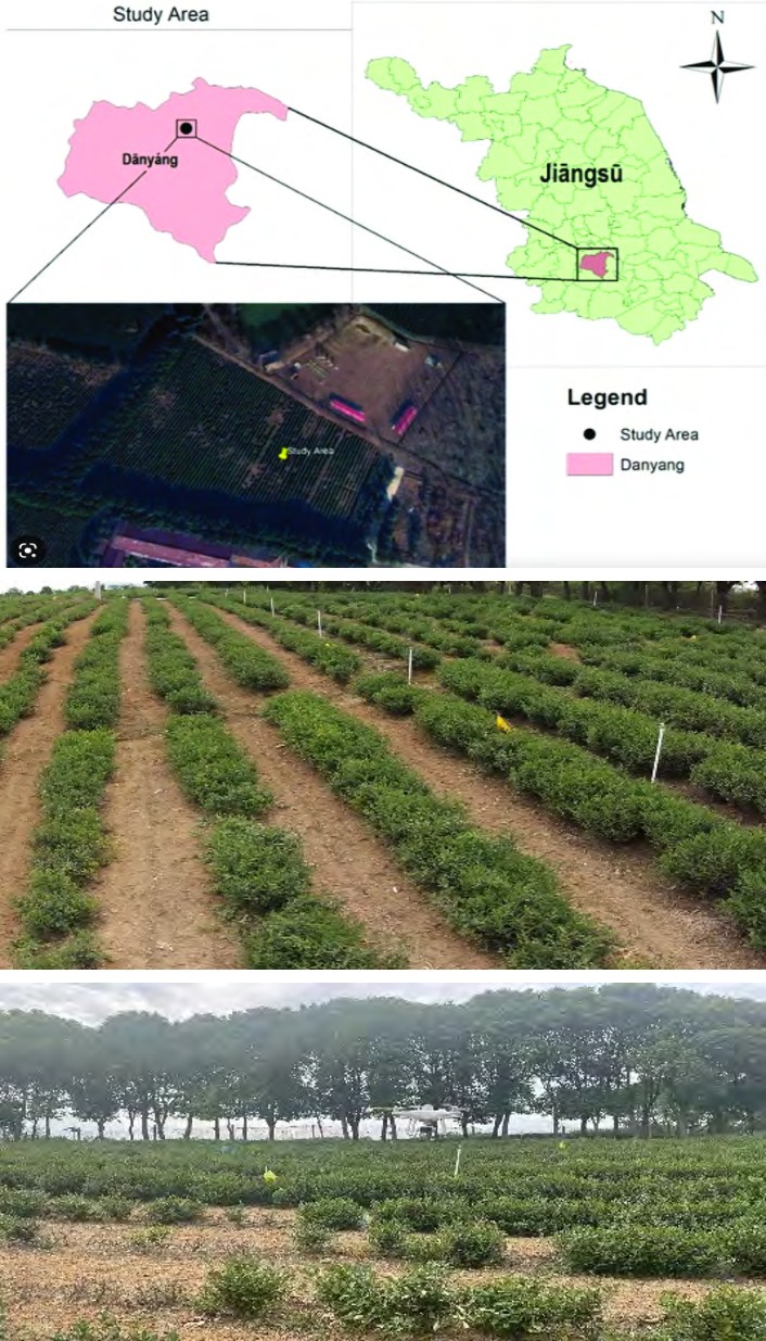
This research was conducted in the 5-acre tea field in cultivated land located at Danyang (32° 1′00″N, 119°4′ 00″E) about 60km from Zhenjiang City, Jiangsu Province, China Figure 1 [3]. It is located in the coastal urban belt and belongs to the subtropical monsoon climate the tea cultivar in the field is Mao green tea. The height of the tea tree canopy is between 0.7m and 0.8m (preferably 0.75m), the soil in the field is silty loam with a PH of about 5, and the field water capacity is about 25%. The experimental site is shown in Figure 1.
Intelligent System
Figure 2 shows the design framework of the system, which deeply integrates the digital twin, the internet of things, big data, wireless transmission technology, cloud computing, and automatic control technology to build a physical layer, a data acquisition layer, a twin model layer, a functional layer, and an application layer. In addition, it is necessary to build the hardware perception and control system of the digital twin irrigation system from the perspective of the system level. With the help of various types of sensors and electrical control methods, the interconnection and intercommunication of various types of irrigation equipment in farmland can be realized, so as to carry out unified information operation, maintenance, and control (Figures 2A- 2C).
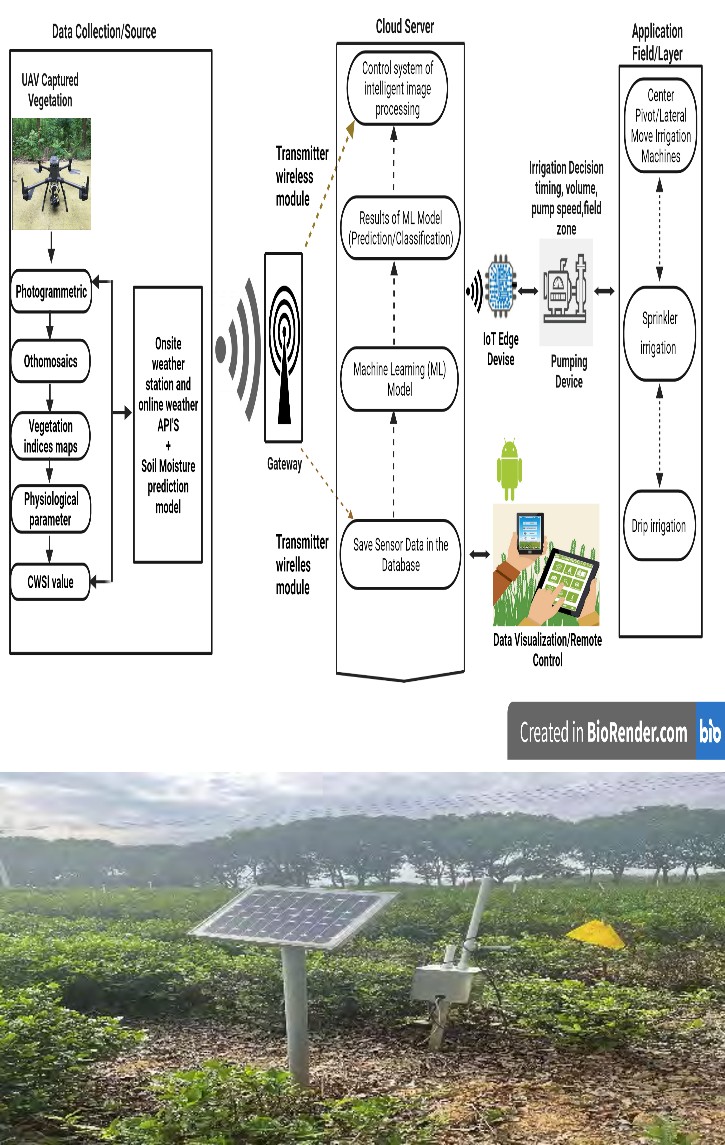
Figure 2A
Figure 2B Figure 2C Figure 2: Intelligent system design and on-site field experiment.
Results and Discussion
This paper randomly selects multiple farmland images from the image database to verify the effectiveness and correctness of the algorithm. It can be seen from the splicing results that the images are stitched correctly, and there is no gap between the images Figure 2C. The splicing effect fully meets the practical application requirements and dramatically improves the splicing efficiency complete field automatic irrigation control system was built through the whole system design and the selection of the system hardware. The canopy temperature can be calculated from infrared thermal imaging. Further, establish and quantify intelligent and efficient irrigation systems benefits and build precise irrigation technology models and specifications. This study results could serve as vital reference information for establishing a workflow and achieved relatively ideal results through the extensive application of UAV thermal infrared technology in agricultural water deficit.
References
-
Becker R (2015) World Population Expected to Reach 9.7 Billion by 2050. National Geographic, United Nations.
-
Abdullah FA, Samah BAJASS (2013) Factors Impinging Farmers Use of Agriculture Technology. Asian Social Science 9(3): 120.
-
Awais M, Li W, Cheema MJM, Hussain S, AlGarni TS, Liu C, et al. (2021) Remotely Sensed Identification of Canopy Characteristics Using UAV-Based Imagery Under Unstable Environmental Conditions. 22: 101465.
- Enhancement of Vegetative Growth and Fruit Yield in Cucumber (Cucumis sativus L.) via Spiritual Blessing (Biofield) Energy Intervention
- Production of Açaí (Euterpe oleracea Mart.) under Different Agroforestry System Management Intensities in Amazonian Floodplain (Varzea) Forests
- Coffee and the Production Region: What is the Secret to the Expression "Quality"?
- Experiential Agripreneurship Training in Sub-Saharan Africa: Integrating a Business Incubator into Postgraduate Livestock Education at the University of Buea
- Advances in Agricultural High-Quality Development
- Linking Compost Residue to ABAGE in Plants - a Short Note