Water Security Plan for the Sustainable Development of Water Resources of Amini Jalgram, Union Territory of Lakshadweep, South India
The Water Security Plan for the sustainability of Water Resources of Amini Jalgram, Union Territory of Lakshadweep, South India has been studied. Amini Island is one of the smallest inhabited islands of the Union Territory of Lakshadweep having an area of 2.60 km2, where the fragile ground water resource is occurring as lens over marine water. Amini Island is entirely different from that existing in the main land. On the basis of the hydrogeological investigations and other related studies, certain participatory water management programs are to be urgently initiated in the island for the sustainability of water resources of the study area.
Introduction
Lakshadweep Islands (LD Islands) are a group of tiny coral Islands, located in the Arabian Sea, about 400 km from the main land (southern tip of the Indian peninsula).
Study Area
Amini Island having an aerial extent of 2.50 km2 is elliptical in shape, located between Kadmath and Kavarati (in the N-S direction) and between Agathi and Androth (in the E-W direction) in a NE-SW alignment. The island is 58 km SW of Kiltan Island, 294 km from Mangalore, 324 km Kozhikode and 407 km Kochi. It lies between north latitudes 110°7’ 00” and 11°08’00” and east longitude 72°44’ 00” and 72°45’ 00”. March to May is the hottest period of the year. The temperature ranges from 25°C to 35°C and humidity 70-76 per cent for most of the year. The area receives an average annual rainfall of 1600 mm. Monsoon prevails from 15th May to 15th September.
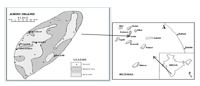
The location map of LD islands including Amini Island is compiled (Figure 1). The coral island is formed by coral polyps and they congregate in large colonies. Charles Darwin first described the different types of coral reef after his voyage by HMS Beagle among the Galapagos Isles in Pacific Ocean (Subsidence theory for the origin of coral reefs). In oceanic island fresh ground water occurs as a lens floating over saline water. The hydro dynamic balance of fresh and saline water determines the shape and movement of interface and may be controlled by some of the following factors viz. water table fluctuation due to diurnal tides, seasonal fluctuation of water table due to recharge or draft, dispersion and molecular diffusion. Due to these factors there is an alternate up and down movement of the interface.
Island at A Glance
Name of Jal Gram: Amini Spatial Location: Latitude-11° 07’ 00” to 11°08’00”, Longitude-72° 44’ 00” to 72° 45’ 00” Block/Taluk/Mandal: Not applicable District: Amini State/U.T.: U.T. of Lakshadweep Nearest Town (with Distance): Kozhikode – 324 km. Nearest Railway Station: Not present Postal Address of Gram Panchayat with PIN Code: Amini Dweep Panchayat, Amini P.O, PIN- 682552, U.T. Of Lakshadweep Area: The total area of the village/island is 2.60 Km2). Population: As per 2011 Census statistics, total population of the island is 7661, out of which male population is 3829 and female population is 3832. The population density of the island is 2958. Having the highest population density among the islands of the U.T and a decadal growth rate of 10.34% (between 2001 and 2011). The literacy rate in Amini Island is 92%.
Physiographical Description: The atoll has a northeast- southwest orientation with an island in the central part with well-developed reefs on the west and east sides with a narrow lagoon in between. Geomorphologically, the island has lagoon beach, storm beaches, beach ridges, sand dunes and hinterland. The island is generally flat with localized depressions and sand mounds, which are largely man-made. The island is situated on the eastern reef margin. The ground elevation of Amini Island is generally between 1 and 7m amsl. The island is having a more or less flat topography with occasional sand dunes on the western side and storm beach on the eastern side. The storm beach consists of coral pebbles and boulders piled up above high tide level. River & Drainage System: The Island is devoid of any natural drainage. Climate: The Island experiences a pleasant and equable climate throughout the year. The climate of the island can be described as tropical wet and dry as per Koppen climate classification. The various seasons in the island can be divided as a) Winter: December to February b) Summer: March to May c) Monsoon: 1. Southwest monsoon - June to September 2. Northeast monsoon - October to November Temperature: The Panchayat has a humid climate with an oppressive hot season from March to the end of May. This is followed by the South-West monsoon which, continues till the end of September. October and November form the post-monsoon or retreating monsoon season. The North-East monsoon which follows extends up to the end of February, although the rain generally ceases after December. During the months of April and May, the mean minimum and maximum temperature of 26.80C and 33.10C respectively. Temperature is low in December and January months the mean minimum and maximum temperature are of 24.0°C and 31.1°C respectively. Rainfall: The IMD maintains a weather station at Amini Island. The Amini Island has normal annual rainfall of 1554.90 mm. A maximum of 70.6% percent of it occurs during the period of South -West monsoon, 17.8% is received during the North-East monsoon period and 11% is received during summer months. The annual variability of rainfall is 22.6%.
Soil: Most of the islands of Lakshadweep have a soil layer overlying coral limestone. The soils are mainly derived from coral limestones and include coral sands, lagoon sands and mud. From a ground water resources perspective, the relevant soil characteristics are the rate of infiltration, the thickness and the moisture contents at both field capacity and wilting point. The soils over most of the island are highly permeable and allow rainfall to readily infiltrate; with the result that surface run-off does not occur except in local areas of compacted soils. In some areas of the islands of Lakshadweep, such as along the coast and around the lagoon, the soils are far less permeable and ponded water is often found after rainfall. These less permeable soils cover a small proportion only of the islands and it can reasonably be assumed from a water resources viewpoint that surface runoff into the sea or lagoon is nil. Irrigation Facilities: The Island doesn’t practice irrigated agriculture. Vegetation: From a water balance viewpoint, the vegetation in Lakshadweep Islands can be classified as either shallow rooted or deep rooted. The shallow rooted vegetation which includes grasses, crops and shrubs obtain their moisture requirements from the soil moisture zone. The deep-rooted vegetation consists of those trees whose roots can, where conditions are favorable, penetrate below the soil moisture zone and through the unsaturated zone to the water table. Coconut trees are a typical example of deep-rooted vegetation in the islands of Lakshadweep. In relatively shallow areas, coconut trees typically have some roots within the soil moisture zone and some which penetrate to the water table. The significance of roots which can reach the water table is that transpiration can occur directly from the freshwater lens, even during drought periods. Vegetation of this type is referred to as phreatophytes and is common on coral atolls where the depth to the water table is typically 2 to 3 m. below ground level. Coconut trees have been reported to extend their roots to a depth of at least 5.5 m. There is no direct evidence to substantiate the rooting depth of coconut trees in Lakshadweep islands but it could reasonably be assumed that a proportion of the roots of coconut trees growing on areas of the islands where the depth to water table is 5m or less can reach the water table.
Agriculture: Agriculture is not a primary occupation of the people of the island. In the island coconut is the only cultivated crop. Animal Husbandry: Animal husbandry activities play a crucial role in the socio-economic transformation of rural areas, especially in generating employment and income to the weaker sections of the population. Generally, cattle (goat) and poultry farming are the allied occupations of island. Mines and Minerals: No reported mines and mineral deposits exist in the island. Industrialization: The industrial development in the area is negligible except certain government owned factories engaged in making some value-added products based on coconut like coconut oil, desiccated coconut powder and coconut fiber. Transport & Communication: The Amini Island is connected with other parts of the mainland and to nearby places of the U.T by all-weather ships and speed boats. Hydrogeology of the Island: The Lakshadweep islands are made up of coral reefs and materials derived from them, generally enclosing a lagoon. Hard coral limestones are exposed along the beaches of islands during low tides and also in well sections. Hard pebbles of coral limestones along with coral sand are generally seen. Beneath a thin layer of vegetal humus there is fine coral sand extending over the surface of all the islands. Below this is a compact crust of fine conglomerate looking like coarse oolitic limestones with embedded bits and shell, and beneath this crust there is another layer of sand. The coral sands and the coral limestones form the principal aquifer in all the islands. Ground water, existing under phreatic conditions at a depth of 2-3m below ground level, is seen as a thin lens floating over and in hydraulic continuity with the sea water. Large diameter wells are the most common and traditional ground water abstraction structures. In almost all the wells, hard coral limestones are exposed near the bottom. The sand below this hard layer has caved in most of the wells. The hydro geological conditions of all the islands are almost similar, with fresh water floats over seawater in hydraulic continuity with it (Figure 2).
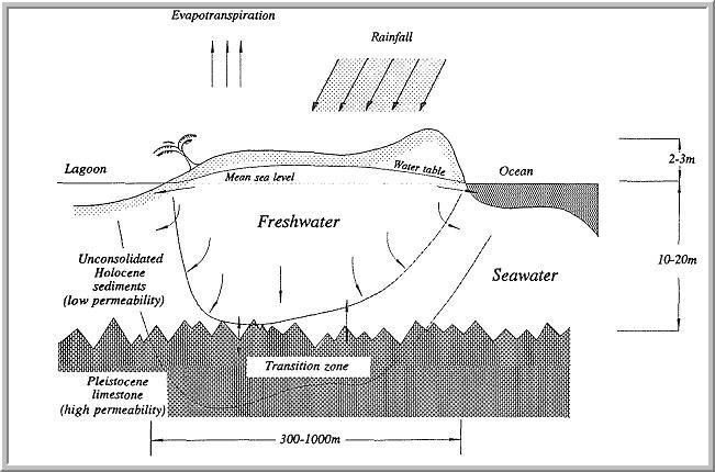
The calcareous sands overlying these islands are highly porous and infiltrate bulk of the rainfall received. The infiltrating rainfall displaces the saline water to a freshwater lens due to density difference and the hydraulic continuity of ground water with seawater. There is no rejected recharge of ground water even during heavy rainfall. About 18 to 51 percent of the annual rainfall gets recharged into the ground water depending on the intensity, frequency and distribution of rainfall. However, the rise in water level due to recharge gets adjusted within the lens and hence appreciable increment in the water level is not observed. Rainfall received in the Lakshadweep Islands are fully recharged and adjusted in the fresh water lens, as a result of which significant rise in water levels are not discernible in the wells even after the monsoon rains.
The coral atolls generally consist of a layer of recent (Holocene) sediments, comprising mainly coral sands and fragments or coral, on top of older limestones. An unconformity separates these two layers at typical depths of 10m to 20 m below mean sea level. Several deeper unconformities may exist due to fluctuations in sea level which results in alternate periods of emergence and submergence of the atoll. During periods of emergence, solution and erosion of the reef platform can occur, while further deposition of coral limestones can occur during periods of submergence. The upper sediments are of primary importance from a hydrogeological viewpoint as freshwater lenses occur solely or mainly within this layer. The occurrence of such lenses within this layer is due to its moderate permeability (Typically 5 to 10 m/day) compared with higher permeability of the older limestones (typically 50 to 100 m/day). Permeability greater than 1000m/day occurs in solution cavities within the limestones. This extremely high permeability allows almost unrestricted mixing of freshwater and sea water which is less likely to occur in the upper sediments. The upper unconformity, therefore, is one of the main controlling features of the depth of freshwater lens. As the ground water is in hydraulic continuity with seawater, it is highly influenced by the diurnal tidal fluctuations of the sea. The magnitude of the tidal fluctuation is dependent on several factors amongst which the permeability of the aquifer material, the proximity of the site to the sea and the magnitude of tidal variation in the sea play significant roles. There is a time lag between tidal fluctuation in the sea and in the ground water levels, which is also dependent on the above factors.
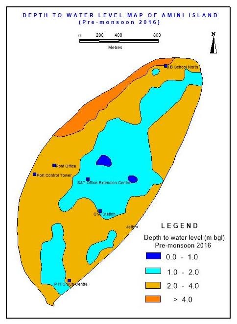
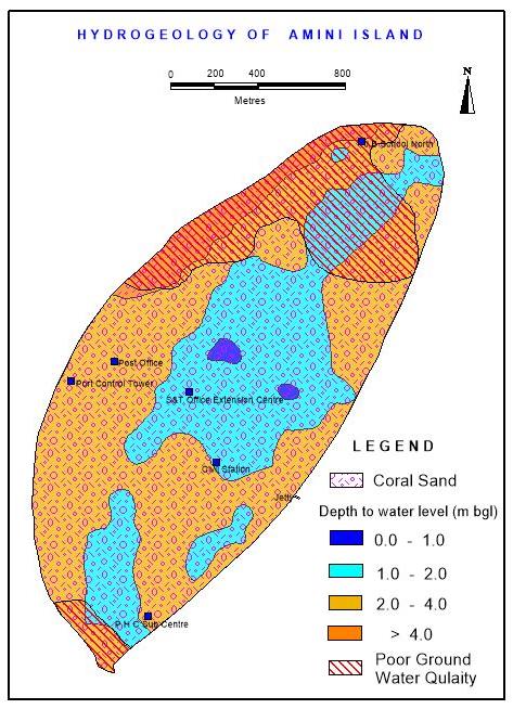
Amini is located on the north-central part of the Lakshadweep archipelago. It is elliptical in shape and is oriented in a roughly NE-SW direction. Amini Island is quite unique by having a lagoon all around it unlike most of the other islands with a fringing reef on the eastern periphery and a lagoon on their west. The freshwater availability in this island is limited to central part, while it is brackish in the south western and north eastern parts. The depth to water varies from 1.2 to 4.8 meters below ground level (mbgl) and depth of wells range from 1.6 to 5.5 m bgl. There are 1050 domestic dug wells with a density of about 420 wells/ sq. km. The depth to the water table and hydrogeological maps has been prepared (Figures 3 & 4).
Sources of Water
The main source of freshwater in the island is ground water. Open, manually dug wells are the traditional method used by the islanders to obtain freshwater for their basic needs. As the depth from the surface to the groundwater table is generally just a few meters, and the soil is fairly easy to excavate by hand, open wells or pits, 1m to 2m in diameter, are excavated to depth of 30 to 90 cm below groundwater table. Almost every household is having a dug well which is mainly used for domestic purposes. Some are drawing water for coconut seedlings or for cattle breeding. The islanders have been conserving water by using step wells, ponds or tanks for washing and bathing purposes. But recent trend is to use small capacity centrifugal pumps mostly of 1/2 HP capacity for their domestic needs. The lack of surface and ground water storage capacity in these islands, in spite of high rainfall, makes freshwater resources a dear commodity.
- Quantitative Assessment of Water Resources
- The dynamic ground water resources have been assessed by computing various components of recharge and draft.
- # Annual components of Water Balance
- Details
- 1
- Population (As on 2013)
- 7719
- 2
- Area (Ha)
- 259
- 3
- Normal Monsoon Rainfall (m)
- 1.326
- 4
- Rainfall Infiltration Factor (%)
- 30
- 5 Total Resource (Water Surplus) (Ha.m))
- [2*3*4]
- 103.0
- 6
- ET loss from Trees for 6 non-monsoon months (Ha.m)
- 27.8
- 7 Water loss due to outflow to sea [20% of
- (3) (Ha.m)]
- 20.6
- Buffer zone for reserve during delayed or
- 8 lesser monsoon period [ 20% of (3)]
- 20.6
- (Ha.m)
- 9
- Balance available resource (Ha.m)
- 34.1
- 10 Domestic draft @100 lpcd [1*100*365]
- (Ha.m)
- 28.2
- 11
- Gross Annual GW Draft (Ha.m)
- 28.2
- 12
- Groundwater balance available [7-9]
- (Ha.m)
- 5.9
- 13
- Stage of ground water development
- [11*100/9]
- 82.7
- 14
- Category
- Semi-Critical
Table 1: Dynamic Ground Water Resources of Amini
Rainfall is the only source of recharge in the Islands, whereas domestic draft, evapotranspiration losses and water loss due to outflow into the sea are the major components of draft. A part (20%) of the annual water surplus is reserved as buffer zone for reserve during delayed or deficit monsoon years. The computational details and island wise recharge figures are given in Table1.
Quality of Water
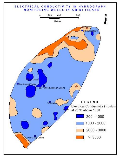
The ground water in the island is generally alkaline with a few exceptions. The electrical conductivity (EC) ranges from 500 to 15,000 µS /cm at 250C and the spacial distribution of EC has been depicted (Figure 5). Higher concentration of dissolved solids is generally seen along the periphery of the island and also close to pumping centres. The quality variation is vertical, temporal and also lateral. The quality is highly variable and reversible. It is also observed that the quality improves with rainfall. Other factors affecting the quality are tides, ground water recharge and draft. There is a vertical variation of quality due to the zone of interface and underlying sea water. Perforation created due to drilling or otherwise also affects the quality as it acts as a conduit for flow of sea water.
Wells manually operated retain more or less the same quality of ground water over longer time periods as compared to mechanized wells where, quality deterioration is observed in the form of increasing EC.
Brackish water is present along topographic lows and in places where coarse pebbles and corals are present. Another major threat to ground water in the islands is the pollution. The human and livestock wastes, oil spills are the main polluting agents with sewerage and other biological wastes contributing most.
Demand of Water
The major demand for water in the village is to meet the domestic purposes. No major industries except few minor coconut-based value-added products manufacturing units in the northern part. The domestic need of water in the island is affected by increase in salinity during prolonged period of drought in the wells during summer seasons especially in the March-May months. The Panchayat even faces difficulty in catering the domestic needs during these months and are managed by supplying water the existing two infiltration galleries (radial collector wells) located in the central part f the island. The major cause of shortage is assessed to be the high rate of saline ingress in wells due to mechanized pumping and increase in demand for non-domestic purposes like construction activities and pollution due surface sources like septic tanks and waste disposal sites. Irrigation Sector: As the island doesn’t practice irrigated cultivation the irrigation water demand is zero. Domestic Consumption: The total population of the island is 5404 nos., and the total annual draft for domestic use is calculated as 27.9 ha m.
Present Status of Development
From the rough estimate of the ground water resources available in the island, it is identified that the total groundwater resources available in the island is about 34.1 ha m. and the total draft is estimated to be 27.9 ha m. Hence the stage of development of the groundwater resource in the island is about 82%. Irrigation Sector: The gross draft for irrigation in the island is zero.
Domestic Consumption
The existing arrangement for drinking water supply is only partially meeting the requirement by combined source of ground water and rainwater sources. The total number of rain water harvesting tanks in the island is 459 and the number of wells identified for water supply is 4. The numbers of overhead tanks are 2 and the number of ground water sumps is 1. Out of the total 1375 households in the island about 280 households in the poor groundwater quality area receives treated/non- treated piped water supply through public taps. Panchayath is responsible for supply and distribution of water. Grant and aid are provided by LPWD to village Dweep Panchayath (VDP) for running and maintenance of the water supply scheme. LPWD water quality laboratory is available in the island for ensuring the quality of the distributed water. The domestic daft of the panchayat is found to be about 20 ha m. The major chunk of the total ground water draft is the island is contributed from domestic use.
Gap Assessment
The amount of water supplied through rainwater harvesting is 4.92 lpcd leaving behind a deficit of 35.08 lpcd. Proposal for low temperature thermal desalination (LTTD) plant is submitted and is in the advanced stage f approval. Once the plant if commissioned the deficit may reduce to 15.51 lpcd.
From the preliminary analysis is clear that the Amini island has got enough groundwater resources are available to improve the domestic demands to reach the final goal of “Water Secure Village”. Estimation of the groundwater resources shows that a total available groundwater resource of the village is 34.1 ha m, and the demand is 27.9 ha m. This Figure demands for further development of the source available in this island through rainwater harvesting and improving the quality of water in the poor groundwater quality area through suitable groundwater management practices.
Solutions
The inability to utilize the water available from rainfall and the lack of judicious management of available water resources are mainly responsible for the present water status of the village. The main thrust areas are the, rain water harvesting and creating awareness to the public which can bring a spectacular improvement in the quality of ground water and drinking water supply status of this island.
For the development of the Island to water sustainable, the participation or involvement of every single islander is necessary. Participatory water management programs are to be initiated and these include 1. Community based water monitoring, 2. Construction of rainwater harvesting tanks,
3. Control on the extraction of ground water through motors to prevent upcoming, 4. Hand drawn wells to be encouraged over energized wells and Pumps above 0.25 hp should not be allowed. 5. Installation of desalination plants in the Island to reduce stress on ground water 6. Installation of rainwater harvesting should be made mandatory for civil constructions, 7. Judicious pumping from freshwater lens through radial wells 8. Judicious use of ground water, 9. Mass awareness programs, 10. Proper plan for water allocation for different sectors as per priority. 11. Proper water budgeting (if possible, on a daily time step), and 12. Repair, renovation and restoration of existing and abandoned water bodies like well, ponds, 13. The constitution of Lakshadweep Ground Water Authority needs to be expedited. 14. The pumping of water from dug wells directly to multi storied buildings may be stopped and the water may be pumped from dug wells with low capacity pump and collected in ground level storage tanks and from this water may be pumped to multi storied buildings. 15. The water supply schemes must resort to a combination of ground water, desalinated water and rainwater harvesting.
A comprehensive integrated water security plan may be prepared by the village/island level committee. The plan should include information on present source of water in the island, its availability, both quantity and quality requirement and gap between requirement and availability. U.T. level committee can plan schemes and work to be taken up depending upon local need and availability.
Conclusion
Water Security Plan for the Sustainable Development of Water Resources of Amini Jalgram, Union Territory of Lakshadweep, South India has been examined in the work. The various measures urgently required for the sustainability of the meagre ground water resources of Amini have been proposed. These include regular water level monitoring, rainwater harvesting tanks to be established, pumping by using high HP motors to be discouraged, hand drawn wells to be encouraged over energized wells and pumps above 0.25 hp should not be allowed. The installation of desalination plants, roof top rain water harvesting should be made mandatory, use of radial wells, mass awareness programs on water conservation at grass root level, the constitution of Lakshadweep Ground Water Authority for regulating the water use and the water supply schemes must resort to a combination of ground water, desalinated water and rainwater harvesting are other recommendations for the sustainability of meagre and fragile ground water resources of the island.
Acknowledgement
The author is grateful to Regional Director, Central Ground Water Board, Ministry of Water Resources, River Development & Ganga Rejuvenation, Govt. of India, Kerala Region, Thiruvananthapuram for all the encouragement given during the course of the work. Thanks are also due to Himaganga Joji, daughter of the author for the data entry and editing of the manuscript.
References
-
Kura NU, Ramli MF, Sulaiman WN, Ibrahim S, Aris AZ, et al. (2013) Evaluation of Factors Influencing the Groundwater Chemistry in a Small Tropical Island of Malaysia. Int J Environ Res Public Health 10(5): 1861- 1881.
-
Aris AZ, Abdullah MH, Ahmed A, Woong KK (2007) Controlling factors of groundwater hydrochemistry in a small island’s aquifer. International Journal of Environmental Science & Technology 4(4): 441-450.
-
Belkhiria L, Mounib L, Boudoukha A (2012) Geochemical evolution of groundwater in an alluvial aquifer: Case of El Eulma aquifer, East Algeria. J Afr Earth Sci 66: 46-55.
-
Joji VS (2016) Sustainable Water Development and Suitability of Ground Water for Irrigation Purposes in a Small Coral Island of Minicoy, Union Territory of Lakshadweep, India. J Indian Soc Coastal Agric Res 34(1): 97-109.
-
Joji VS (2016) Major Ion Chemistry and Identification of Hydrogeochemical Processes of Evolution of Ground Water in a Small Tropical Coral Island of Minicoy, Union Territory of Lakshadweep, India. MOJ Eco Environ Sci 1(2): 00008.
-
Joji VS (2017) Groundwater Resources Appraisal in the Tropical Coral Island of Kalpeni, UT of Lakshadweep, India. Inter J Environ Monitoring and Protection 4(5): 52-63.
-
Arslan H (2013) Application of multivariate statistical techniques in the assessment of groundwater quality in seawater intrusion area in Bafra Plain, Turkey. Environ Monit Assess 185(3): 2439-2452.
-
Kumar G, Prabakaran K, Selvam G (2015) Assessment of groundwater quality for Veppanthattai taluk, Perambalur district, Tamil Nadu using Remote Sensing and GIS techniques. Inter J Recent Scientific Research 6(3): 3142-3146.
- Genetic Improvement of Nile Tilapia (Oreochromis niloticus): Advances in Selective Breeding and Genomic Approaches for Sustainable Aquaculture
- Microplastics, Contaminants, and Waste Hotspots: Divergences and Faults in Prioritizing Control Efforts
- Creating a Healthier, More Vibrant Open and Closed Aquatic Environment. A Submersible, Centrifugal Magnetically Affixed Current Changing Aquarium Pump
- An Attempt to Assess Alpha Diversity and Sample Size: Using the Ostracod Assemblages off Kumamoto Port, Japan
- Assessment of the Efficiency of Common Fishing Gears and Crafts Used at Mohananda River of Chapai Nawabganj, Bangladesh
- Fish Productivity and Biodiversity Status of Sundarban Mangrove in Bangladesh