Origin of Ancient Civilisations The Southern Hemisphere’ Scenario
The theory of cultural diffusion throughout the world from the Fertile Crescent has been definitively abandoned when numerous civilizations turned out to be older than their supposed Middle Eastern models. Unfortunately, it has not been replaced by any new theory capable of explaining the simultaneous rise in various parts of the world, after the end of the Pleistocene, of civilizations with extraordinarily similar contents, apparently without any mutual contact.
Abbreviation
ECD: Earth Crust Displacement.
Introduction
The solution to this problem most likely lays in the events that brought the Pleistocene to an end. This period is characterized by a climatic situation so different from the current one, that the only plausible explanation seems to be that the poles were in a different position. This is definitely denied by archaeologists, because it is not known any mechanism capable of causing a shift of the poles of the amplitude and rapidity required by the observed phenomena.
An accurate analysis, however, demonstrates that the Earth is an essentially unstable planet, due its plasticity and to the enormous extension of the free liquid surface that covers it. Simple calculations show that the impulsive torque caused by the impact of an asteroid less than one kilometre is enough to trigger a process that within days or weeks causes a remodelling of the equatorial bulge, thus provoking a large displacement of the poles. Apparently, this phenomenon occurred at the end of Pleistocene, provoking a shift of the North Pole from northeastern Canada to its current location, and a symmetrical shift of the South Pole.
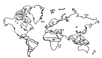
In this scenario, the geographical situation of the planet before the shift was radically different from today, in particular in the southern hemisphere. Antarctica and South America were displaced of about 20° towards North, while South-East Asia was shifted of the same amount toward South. In this way the whole Indian ocean was below the equatorial line, and a warm oceanic stream flowed from Indochina directly to the strait of Drake. Any boat that escaped from the coasts of Asia were inevitably dragged towards Antarctica and South America. This must have happened many times since 50 thousand years ago, when Indonesian palaeolithic populations developed means capable of navigating the open ocean (it is then, in fact, that Australia was colonized).
Thanks to these ancient seafarers, the first human civilization developed in isolation in the southern hemisphere. This civilization was destroyed by the catastrophe that put an end to the Pleistocene, but its “fragments” were scattered along the coasts of the whole world, where each of them gave rise, in total autonomy, to the ancient known civilizations.
Climatic Situation at the End of Pleistocene
Between 50 and 12 thousand years ago an impressive ice cap, two-miles thick, spread from the Hudson area southward down to the actual New York’s latitude, and westward to join, at its maximum extent, glaciers flowing from the Rocky Mountains in Alaska. During the same period North Europe was also covered by an icecap, which at its maximum extent reached the latitude of London and Berlin. The quantity of water trapped in these ice sheets was so large that at their maximum the sea level was about 130 metres lower than today.
The current explanation provided for the existence of these ice caps is that they were due to a cooler climate all over the world. But this theory is contradicted by the absence of ice sheets in Siberia, which was populated, up to its northernmost regions well inside the Arctic Sea, by one of the most impressive zoological communities of all times, proving that the climate around the Siberian Artic was milder than today [1].
The barycentre of these excentric polar icecaps fell very far from the actual North pole, between Greenland and the Baffin Island. We should deduce, therefore, that the north pole fell near this barycentre, otherwise it is quite impossible to justify a polar climate localized on East Canada and North Europe, whatever the supposed drop of temperature might have been.
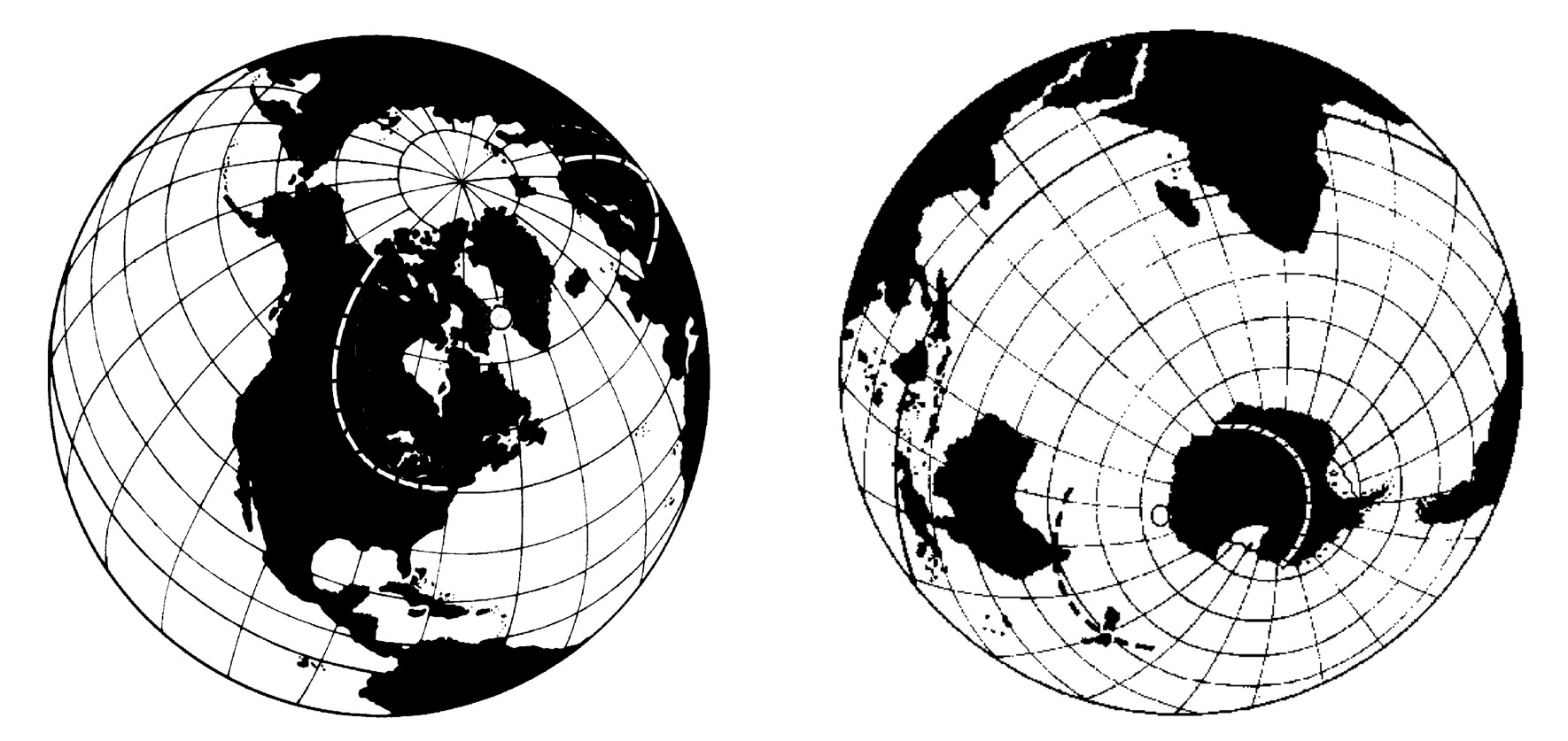
As a consequence, we must assume that also the icecap of the southern hemisphere was excentric with respect to the actual south pole, with its barycentre displaced towards Australia, symmetrically with respect to the barycentre of the northern icecap. The south pole, therefore, had to be situated on the edge of Antarctica facing Tasmania. This part of the continent had to be completely covered by ice as of today and New Zealand, Tasmania, and some part of Australia had to be subject to a polar climate.
The coasts of Antarctica facing America and Africa, instead, from Palmer Peninsula up to Mackenzie Bay, must have been mostly free of ice, although crossed by large glaciers that discharged the ice from inside the continent into the ocean. And there had to be also plenty of rivers alimented by the waters of the melting continental icecap. We therefore conclude that, most of the ice that now covers this part of Antarctica must be very recent, not older than 12 thousand years.
This scenario is obligated if we assume that the pleistocenic glaciation was due to a different position of the poles. Apparently, it is challenged by British researchers who collected ice cores in the area of Weddell [2]. But their conclusions were so confused, contradictory and evidently biased in support of the narrative that explains the existence and disappearance of the northern ice-caps based only on changes of temperature, that are hardly credible (Figure 1).
Evidence that the Poles have Shifted
The scenario proposed to justify the climatic situation during the Pleistocene requires that somehow the poles moved to the actual position at the end of this period. Besides this shift must have been very quick, at least in geological terms.
It is well known that the poles have changed their position on the Earth’s surface during the past geological eras. The marks left by thick ice sheets in Africa and India [3], the residual magnetism in ancient rocks [4], the old coral reefs’ and coal deposits’ distribution [5] and so on, all together are compelling evidence that the poles have wandered from what is today’s tropic to the actual poles [6] (Figure 2).
![Figure 2: The wandering of the North pole during the last 300 million years [7].](/fulltextimages/13962/fig_2.png)
Geologists account this wandering to the drift of continents and to the displacement of large quantities of materials, due to erosion and sedimentation processes, which in theory would provoke a very slow shift of the poles, a few centimetres per year at the most, which in hundreds of millions of years can result in shifts of thousands of kilometres.
Geological evidence, however, seems to indicate that the wandering of the poles was not gradual and continuous, but it happened by “jumps”. According to our scenario a jump of that kind must have occurred about 12.000 years ago. The ice cores, both from Greenland and Antarctica, seem to support this hypothesis. In fact, they show that the end of Pleistocene was marked by an abrupt and permanent change of temperature, that might indicate a change of latitude of the spot where the ice cores were collected (Figure 3).
![Figure 3: Ice cores from Greenland and Antarctica show a permanent change of temperature at the of Pleistocene [8].](/fulltextimages/13962/fig_3.png)
The 10th millennium B.C. appears to be critical under several aspects. It was precisely in that period that the Palaeolithic cultures, which had thrived for more than 30 millennia, all of a sudden disappeared. And all over the world, a megafauna that thrived for more than 100.000 years declined to extinction A geological era, the Pleistocene, came to an end, marked by a burst of volcanism, strong earthquakes, and unprecedented floods all over the world, due to exceptional rains and temporary fluctuation of the sea level. All phenomena that cannot be explained simply by a drop of temperature.
A quick shift of the poles could explain everything in a satisfactory way, but geologists deny this possibility because they cannot figure out a mechanism capable of provoking it.
However, this is the most intuitive and natural explanation for the climatic situation of that time, and in fact it was the first taken into consideration since the 19th century. But some of the greatest scientists of the time, including Maxwell JC [9] and Sir George Darwin [10] (son of the famous Charles Darwin), considered this problem and decided that the stabilising effect of the equatorial bulge was so great that no conceivable force could make the Earth shifting on its axis, except for the collision with a planet-size body. They therefore dismissed the idea of any shift of the poles as impossible and, in fact, not worth discussing.
Yet the evidence is so compelling that an explanation had to be found at any cost. In the years ‘70s the scientist Charles Hapgood [11] proposed the Earth Crust Displacement (ECD) theory, according to which the whole Earth’s crust could slide on the underlying mantle, due to the weight of the polar ice caps, causing the catastrophic events that have characterised the end of Pleistocene., and of course a shift of the poles.
Although approved by scientists of the calibre of Einstein, this theory was dismissed by geologists because incompatible with the plate tectonics, and the principle that the Earth’s poles cannot shift has become a true dogma that nobody dares to discuss. But it is wrong.
Earth is an Unstable Planet
Maxwell statement that “only” a planet-size-impact could make the poles shift was not correct, because there is a much less catastrophic event that could do it, that is the “reshaping” of the equatorial bulge. He himself, in fact, pointed out that the stabilising torque of Earth is developed not by the entire mass of the planet, but only by the equatorial bulge, that is, by a ring of matter which at the equator has a medium thickness of about 15 km, going down to zero at the poles, only the 0,2 % of the terrestrial radius. A small deformation of this 0,2 % can induce wide shifts of the poles, and this can happen without displacing masses from one side to the other of the surface. Centrifugal forces could easily do the job, without impacts on plate tectonics.
Apparently, Maxwell did not consider the fact that Earth is a rather plastic “ball” which can easily be deformed by centrifugal forces. Besides he overlooked a well-known (at least by naval engineers) physical law, according to which free liquid surfaces create instability in every system. Just a look at the extent of the oceans is enough to conclude that Earth is an inherently unstable planet. Let’s see why.
Imagine that somehow Earth should be forced to rotate around an axis shifted of, let’s say, 20 degrees. Inevitably the equatorial bulge would be quickly reshaped around this new axis, because the centrifugal forces would make rebound the surface along the circle normal to it, and the old equator would be flattened [12]. The amount of the mantle’s deformation would not be relevant. The rebound of the new equator at its highest point would be of around 1km, going down to zero at 90°, were it crosses the old equator. Distributed over a semicircle of 20,000 km this means a deformation of the mantle of no more than 5 cm per km. Less for smaller shifts.
The problem is to know what could force Earth to rotate around a shifted axis for a time long enough. Here it is where the water comes to play. We know that tsunamis make the axis wobble; not too much, of course, because the mass of water displaced by a normal tsunami of a few meters is irrelevant. Imagine, instead, a tsunami hundreds of meters high and some thousands km wide moving from the equator towards the poles, or better a tide of that magnitude.
It would make the axis of rotation shift of several degrees. The effect of the tide would be amplified by the fact that the polar icecaps (and the mountains) would become eccentric, thus developing a toppling torque. Therefore, the axis of rotation would be shifted for a time long enough to provoke somewhere a sudden rebound of the Earth’s crust under the action of centrifugal forces. We can discuss if the rebound of the mantle would occur for a shift of the axis of 15 degrees, or 5, or even less, but not to doubt that it would happen. In these conditions it certainly will. This initial rebound would trigger an ample reshaping of the bulge and a consequent permanent shift of the poles.
It now remains to understand what could provoke tsunamis or tides of the required magnitude. In principle nothing prevents that they could happen and there is evidence that in fact they did in the past [13]. Earthquakes, underwater landslides, a sudden slipping in the ocean of large chunks of the Antarctic icecap, a close passage of a planet-size body, impacts of large asteroids?
All of them could provoke big tsunamis, but one of them seems to be the favourite for historical reasons. We know that some of the most catastrophic extinction [14] in the Earth’s history were coincident with the fall of a large asteroid. In particular the extinction of dinosaurs at the end of the Cretaceous by unanimous consensus was provoked precisely by the fall of a 10-km-wide asteroid. What kind of catastrophe could it have provoked, capable of inducing mass extinctions all over the world?
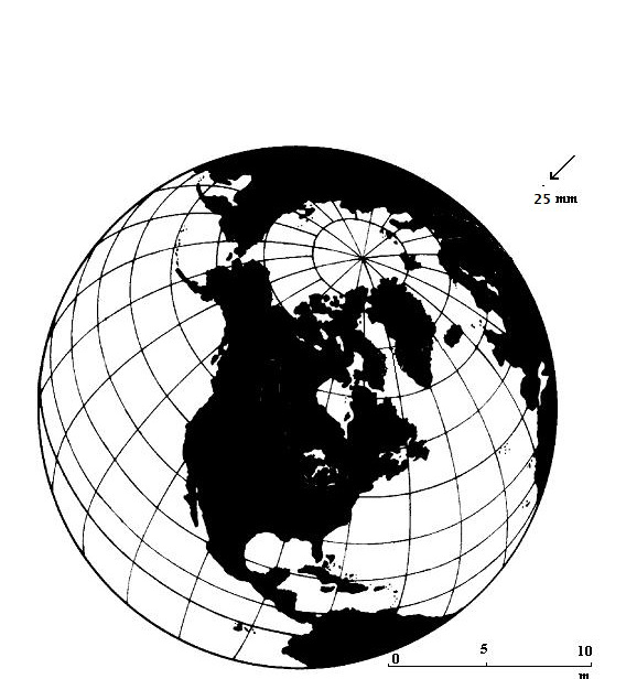
Compared to Earth, a 10-km-wide asteroid is a tiny sphere of 25 mm. in front of a 25 metres ball (Figure 4).
The current scientific explanation is that such an impact provoked a sudden drop of temperature, because of the huge amount of matter injected in the atmosphere [15]. But just looking at the picture, this theory appears not fully convincing, if not plainly inconsistent (to make it more convincing, often drawings where the impacting body has the size of the moon are shown). Somehow that impact must have triggered a much more catastrophic phenomenon than a drop of temperature. A shift of the poles could better explain the mass extinctions, both inland and in the oceans, that followed the impact.
How an Asteroid can Provoke a Shift of the Poles
Due to the large disproportion between Earth and a 10-km-wide asteroid, the possibility that such an impact could induce a shift of the poles seems to be out of the question: the mass of that asteroid, and the associated energy, cannot directly provoke a shift higher than a few centimetres.
However, if mass and energy of the asteroid can be neglected, the same cannot be done for the torque developed by the impact. To understand why, we must consider that the stabilising torque of Earth is developed not by the entire mass of the planet, but only by the equatorial bulge [16]. Due to the very high speed of the asteroid (between 20 and 70 km/sec), provided that the angle of the impact is large enough, the impulsive torque developed could reach a peak value so high as to overtake the reaction torque developed by the equatorial bulge. Just for a short instant, of course, but enough to “trigger” the process which in the end results in a shift of the poles.
It was a discovery that the author made when he analysed, for professional reasons, the behaviour of a gyroscope subject to a torque [17]. In extreme synthesis: it starts to precede around an axis called of precession, and in this way, it develops a reaction torque that counterbalances exactly the disturbing torque. Of course, there is a limit to the value of the reaction torque that the gyro is able to develop. If the disturbing torque overtakes that limit, the gyro collapses (if it is a spinning top it falls) [9]. Before reaching this limit, however, a special condition is achieved when the disturbing torque equalizes exactly the reaction torque. In this case the axis of precession becomes permanent and the gyro plus the disturbing torque behaves like an undisturbed gyro rotating around it. If at this point the torque diminishes, this new axis starts to precede around the previous one, which would be recovered only if and when the torque would be completely spent.
In principle, the behaviour of Earth when subject to a disturbing torque is the same: If the torque developed by an impact equalises the reaction torque developed by the equatorial bulge, the Earth instantly assumes a different “permanent” axis of rotation. An instant later, however, the torque will be spent, but not completely, which means that the Earth would maintain “memory” of the new permanent axis. Initially it would have a very tiny residual rotation, but enough to move some water around the “would be” new equator, thus increasing that rotation, which would move more water and so on and on until forming a tide large enough to provoke a sudden rebound of the crust, thus starting the process of reshaping the equatorial bulge around a new axis, and therefore the poles would be shifted with respect to the mantle (This process is demonstrated in the author’s work “Earth an unstable planet”) [18].
Simple calculations show that a 1-km-wide asteroid, impacting the Earth at high speed and with a wide angle, produces an impulsive torque that can be largely higher than the highest reaction torque possibly developed by the equatorial bulge (see by the author: “Changes in the rotational axis of Earth after asteroid/cometary impacts and their geological effects”) [19].
Myths about the Universal Flood and the End of the World
Obviously, readjustments of the equatorial bulge cannot happen without causing fractures of the crust in areas subjected to strain, with earthquakes of great magnitude and a sudden burst of volcanic activity. But the most destructive phenomena, for what concerns the forms of life, are wide fluctuations of the sea level, submerging temporarily large parts of the continents, and a huge hurricane all over the world, with violent winds and catastrophic floods.
It was precisely in the 10th millennium B.C. that a geological era, the Pleistocene, came to an end, marked by a burst of volcanism, strong earthquakes, and unprecedented floods all over the world, due to exceptional rains and temporary fluctuation of the sea level. Most of the human populations was exterminated. The few survivors were the direct progenitors of today’s populations. 12000 years have elapsed since then, a time that is only twice the length of the historical period. Is it possible that the memory of events of that magnitude has been completely lost? If that big disaster really happened as described, we should find its memory in religions, legends and traditions of practically all the populations of Earth.
In fact, memory of a great catastrophe, the “universal flood”, right at the beginning of the “actual” humankind, is part of the cultural heritage of most of the world populations. Some traditions indicate even the exact epoch.
“9000 years ago... there was an island in front of the strait that you call the Columns of Hercules.”. The author of these words is Plato, the great Athenian philosopher who lived in the 4th Century B.C. In his dialogues “Timaios” and “Kritias” he describes a terrible catastrophe, the destruction of Atlantis, which occurred 9,000 years before his time.
The myths about the universal flood, the end of Atlantis and the end of the world, could be considered evidence related to the end of Pleitocene, characterised by catastrophic events, the most notable of which were wild fluctuations of the sea level and apocalyptic floods. Phenomena that can be provoked only by a shift of the poles, certainly not by a drop of temperature.
At the same time, however, they pose an apparently insurmountable problem to the archaeologists and historians. Those traditions tell us of an advanced civilization existing “before” the end of Pleistocene. The Noah of the Bible, as well as all the others, was a member of a society which practiced agriculture, lived in towns and built large ships. No doubt it was an advanced society, certainly not Paleolithic. Where did this antediluvian civilization develop and what happened to it after the deluge?
Geographic Characteristics of Atlantis
Scientists plainly dismiss what appears to be most accurate and complete description of what happened at the end of Pleistocene, i.e. Plato account, that correctly reports the epoch (which is an extraordinary coincidence) and the events, a fundamental testimony of the most critical period of human history.
Let’s assume, instead, if not else for working reasons, that Plato description is reliable, although with some imprecisions about the location, the level of civilisation and the relations with neighbouring populations of Atlantis. We must consider, in fact, that he is reporting traditions about a reality that existed 9.000 years before his time, which he tries to understand and to describe in a credible way on the light of the geographical, historical and technical knowledge of his epoch.
Plato insists that the island sunk in one day and one night, an impossible event from a geological point of view for large portions of territory. In all evidence it was the level of the sea that raised to submerge the land, at least temporarily, a phenomenon that inevitably occurs during a shift of the poles.
Atlantis, then, has not disappeared our sight, but it must still be visible on our maps; apart obviously, from that stretch of coast which later became submerged by the increase of the sea level caused by the melting of the Pleistocenic icecaps.
Where was it? Plato says that it was located facing the “Columns of Hercules”, but we can be certain that this name, at the time of Atlantis, was not referred to the Strait of Gibraltar. We must assume as reliable the geographical information that describe the island by itself and not in relation to the Mediterranean basin or whatever other location. Based on this information, Atlantis appears to be a well defined geographical entity, but without a precise position. It is up to us to fit it correctly on the map.
Let’s see, then the Characteristics of this Land According to Plato Description: The fundamental point upon which Plato insists again and again is that Atlantis was an island. There can be no hesitation on this point; nor upon the meaning of the word “sea” which surrounded the island. In the Timaios he defines it as “a true sea, because all the sea on this side of the mouth which I have said (the Mediterranean) seems to be a port with a narrow entrance; but the other you could correctly call a true sea”. Nothing could be clearer than this description. It was an ocean.
This ocean was in its turn surrounded by an almost continuous stretch of land; “...and the land that completely encompasses it you could correctly call a true continent”.
Between Atlantis and this super-continent there were numerous smaller islands which formed a sort of bridge between the two; “...the sailors then could pass from (Atlantis) to the other islands and from the islands to all the opposite continent which ranged around that true sea”.
Other important geographical features are the dimensions, the climate and the geological nature of the island. Plato states that it was “larger than Libya and Asia put together”. This is a rather vague indication, but it conveys clear information, which can be made more precise on the base of other geographical information. Kritias provides the dimensions of a great plain “flat and oblong, of 3,000 stadia one way and 2,000 from the sea to the centre”. That plain was surrounded by mountains, which “surpassed in number, greatness and beauty all those now existing”. Plain and mountains formed a single state, or “province” as Plato calls it, whose total surface area can be estimated not to be inferior to 300,000 sq. kilometers. Atlantis, however, was composed of nine more of these “Provinces”, as clearly stated by Plato; “Such was the regulation of the military forces in the province of the supreme king; in each of the nine others it was different”.
The figure of 300,000 sq. kilometres refers to the surface area of only one of them; for the other nine we can reasonably presume that they had an average extension equivalent. In conclusion we find that Atlantis must have had a total surface of the order of millions sq. kilometers. Truly a continent!
As for the climate of the main kingdom, according to Plato’s description it was extraordinarily favorable, such as to make possible the cultivation of a great variety of plants and to produce two harvests a year.
Regarding the geological characteristics of the island, Plato affirms that it “furnished many things for the necessities of life, above all those solid and fusible substances obtained from the mines”. This means that at least all those metals known to antiquity were to be found in abundance; lead, copper, tin, iron, silver and gold.
In conclusion, we must look for an island having an area of millions of sq. kilometres, surrounded by an ocean, itself surrounded by a continuous stretch of continents; an island rich in metals and favored, before the Flood, by a mild climate.
With these indications there is little to choose from; the only land which completely matches these requirements is Antarctica.
This seems to be a ludicrous statement in the actual geographic and climatic situation. However, it is obliged in the geographical situation of the proposed scenario for late Pleistocene, where the south pole is shifted of more than 2000 km towards Australia. In this scenario all the characteristics of Antarctica fit completely Plato’s description, including the detail of the mild climate, as its Atlantic coast is at higher latitude (at least 20°), and most likely heated by a warm oceanic stream (Figure 5).
Geographical Situation of the World at the End of Pleistocene
Let us, then, draw a map showing the geographical situation of the world before the end of Pleistocene, according to the proposed scenario, with Europe, Nord America and Antarctica shifted of about 20° towards north, and Siberia, Australia and New Zeland shifted of the same amount towards south.
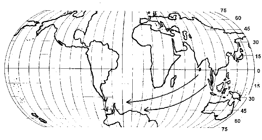
The most significant climatic and geographical change was in the southern hemisphere. Trade winds blew constantly westwards and gave rise to an oceanic current that flowed from Indonesia along the coast of South Africa, pointing directly towards the Strait of Drake. Therefore, South America and the Atlantic coast of Antarctica enjoyed a mild climate.
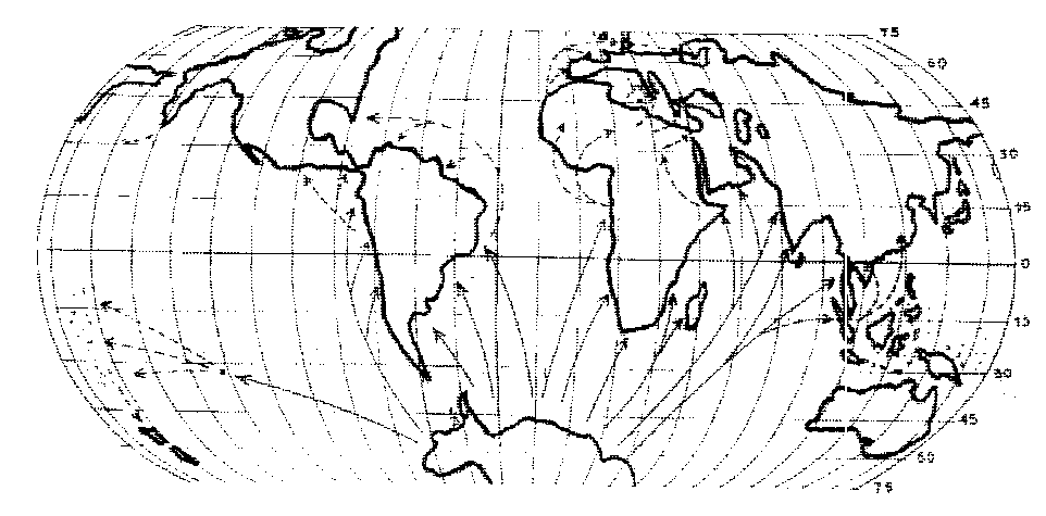
This oceanic stream was important for another reason. Any floating object escaped from the coasts of the Indian Ocean, would have inexorably been transported towards South America and Antarctica (Figure 6).
We know for certain that the Paleolithic populations of Indonesia had developed some kind of boats at least 50.000 years ago. It was precisely on that date, in fact, that men reached Australia, undoubtedly by sea, most likely onboard of rafts, because there were animals with them.
It is highly probable that now and then some rafts escaped from the coasts of Indonesia, in which case they were inevitably dragged directly to Antarctica. During the 40 thousand years that preceded the end of Pleistocene this might have happened several times. Thus, it must be during this long period that man reached for the first time the coasts of Antarctica.
At that time, they enjoyed a mild climate but most of the vegetables that assured the survival of those people in their original land were missing. It was this fact that probably forced those Palaeolithic sailors to make the first experiments of agriculture, planting seeds and vegetables that had been carried onboard their rafts. The invention of agriculture prompted as a consequence the construction of new working tools, new types of dwellings, a new social organisation and so on, the first steps towards a technological civilisation.
A peculiar characteristic of Antarctica at that time, easy to verify on the map, is that it could be reached by floating objects coming from all the coasts of the Indian ocean, but not vice versa. A raft escaped from the coasts of Antarctica would have been carried in circle around the island or right in the middle of the Pacific Ocean. The first civilisation, therefore, must have developed in Antarctica in isolation with the rest of the world, as none could have been able to leave the island and export elsewhere the first fundamental conquests on the way to civilisation.
Only when it achieved a technological level such as to consent the construction of large oceanic vessels they were able to get to the coasts of neighbouring continents. At that point, however, the technological gap between them and the Palaeolithic populations of the northern hemisphere was too big in order to allow any reciprocal influence.
Colonies must have been established along the coasts of other continents, at least of South America. As the level of the sea at that time was lower than today’s, their archaeological remnants are out of reach for modern archaeologists.
The Universal Flood and the Destruction of Atlantis
At the end of Pleistocene Earth was hit by an asteroid or a comet that triggered a shift of the poles. The Atlantic coasts of Antarctica were first submerged by a dramatic rising of the sea level, although temporary, and in the following years they were covered by a thick layer of snow and ice [20]. The survivors took refuge onboard the ships, of which, according to Plato, there were a very high number. Most of them were probably lost during the hurricane, but a certain number managed to reach safely the coasts of America, Africa and Asia. There, each of them, merging with local survivors, gave origin in complete autonomy to a new population, which culture was derived from that of Atlantis (Figure 7).
The universal flood, in conclusion, has provoked the “explosion” of a civilisation, that up to that moment had been confined in Antarctica and in the nearby coasts, scattering its “fragments” all around the world (except Australia, facing the side of Antarctica completely covered by the ice cap). All the non-Palaeolithic cultures of Earth, therefore, should have been originated, in the end, from some groups of survivors of Atlantis. At the beginning they had the same basic culture and the same scientific and historical background, but then they developed in isolation from each other.
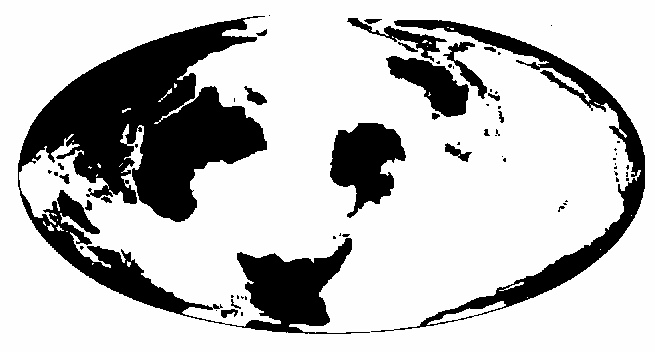
This scenario is proved by the fact that agriculture started after the end of Pleistocene in six different areas of the world, apparently without connections between them: Central and South America, the Fertile Crescent, Central Africa, China and South-East Asia (Figure 8).
The Chronological Gap
The survival of traditions and know-how of a great civilisation presupposes a continuity of which there is no archaeological evidence. There is a gap of about 3 or 4 millennia between the destruction of Atlantis and the rise of the first ancient civilisations of a superior level known so far.
Can we fill this gap? Let’s consider what the situation was immediately after the catastrophe. The first communities of survivors were settled along the coasts. Several centuries had to pass before the population recovered from the disaster. Near the seaside there were the conditions for a civilisation similar to that of Atlantis to be re-established. It is possible that in a few centuries the survivors were able to reconstitute societies not too far from Atlantis’ level. But their remnants were lost.
At the maximum extent of the glaciation, the sea level was 130 meters lower than today’s. At the end of Pleistocene, it was still at least eighty metres below, due to the huge amount of ice trapped in the two northern icecaps. This ice did not melt in one year and not even one century. It took the whole of six millennia for it to be completely melted down. It took more than two thousand years for the European ice cap to be reduced inside the boundaries of Scandinavia; more than four millennia to completely disappear. And it was by far the smaller of the two ice caps (Figure 9).
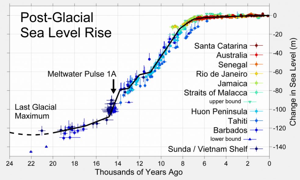
Therefore, during the first six millennia after the deluge, the sea level raised slowly, but inexorably, by several meters each century. Five thousand years ago, when the phenomenon was practically over, it was still about 4 or 5 meters below the present level. Archaeologists and historians seem to underestimate this phenomenon, which necessarily must have had a great influence on the development of human cultures during such a long period.
All the towns and ports that were built near the seaside by the first communities of Atlantis’ survivors, had to be abandoned after a few decades to move inland. And this happened again and again until the sea level was stabilised.
It’s precisely at that epoch that the first great ancient civilisations appear on the scene of history, both in Eurasia and America. Therefore, the link between them and Atlantis is now submerged in the continental platform, where their archaeological remnants wait to be discovered.
Documents Survived from Atlantis
Numerous similarities between the ancient civilisations of the world witness the common origin from an ancient global civilisation disappeared at the end of Pleistocene, and some fundamental instruments of our present civilisation seem to have been inherited by this same civilisation [21].
None of them seems enough to change the negative attitude of historians and archaeologists towards a common origin. The information provided by worldwide mythologies, together with Plato’s account, are simply discarded as non- reliable, and normally reconducted to local limited events.
There are, however, testimonies of ancient documents that cannot be dismissed just with a shrug. In his book “Maps of the Ancient Sea Kings”, [22] Charles Hapgood makes a list of maps “impossible” for their epoch. He explained their existence with the hypothesis that an ancient unknown maritime civilisation at the end of Pleistocene was so advanced as to be able of mapping the entire world in a precise way.
Somehow copies of those maps should have survived and they became the “source” of maps produced by medieval and renaissance cartographers and geographers, which have characteristics apparently inexplicable on the base of the geographic knowledge of that period.
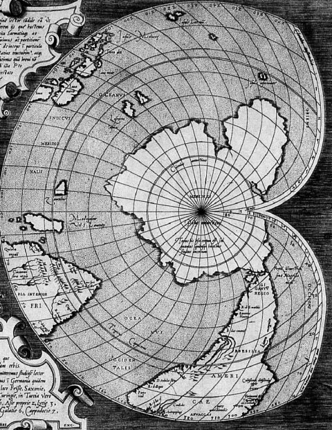
This ancient, advanced civilisation had a special interest in Antarctica, proven by the maps produced by Oronteus Finaeus (1531) and by the great cartographer Mercator, which represent Antarctica in its precise location and, according to Hapgood, with its precise profile at the end of Pleistocene. Evidence that the seat of this civilisation was precisely there is provided by generations of medieval “cartographers”, who were convinced of representing the world in which they were living, while in reality they were reproducing maps of the Pleistocene Antarctica.
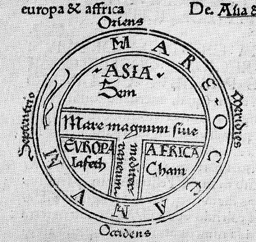
The apex of ancient cartography was reached with Ptolemy. On his map, the Mediterranean basin is represented in a quite precise way; Africa and Asia a little bit less, but their essential characteristics are well defined. The most important characteristic of this representation is that the north pole is at the top, because this is the most natural (I would say obliged) way of a geographic representation for a cartographer living in the northern hemisphere.
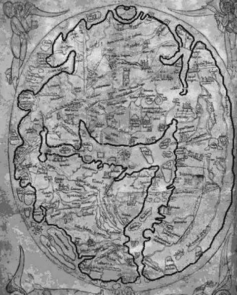
These fundamental conquests of ancient cartography seem to have been lost during the Medium Age in Western Europe, because since the 8th century representations of the world of a totally different kind start to appear. To begin with, the world is represented as a circular island, the profile of which doesn’t match at all with the reality it is intended to reproduce. It looks more in agreement with Omer’s geography, who conceived the world as a circular island surrounded by the “river ocean”, perennially flowing around it.
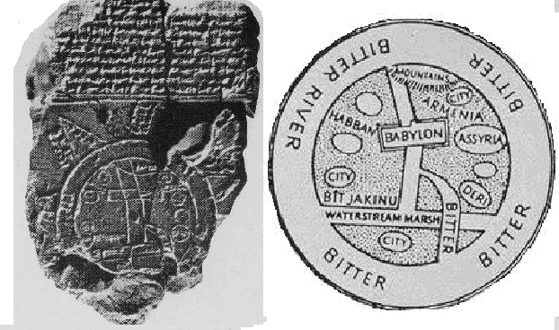
The model which inspired this vision of the world came from a very distant past. We find it in the most ancient representation of the world, a clay tablet of ancient Babylonia (Figure 10).
The medieval planispheres are all inspired to this model. A really surprising innovation with respect to Ptolemaic geography, apparently with no justification, is the fact that the cardinal points are rotated of 90 degrees, with the North on the left and the East on the top of the representation. This is not a minor detail: it is evidence that they were representing a different land and it is fundamental in order to identify that land.
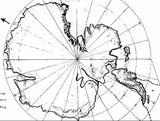
Antarctica at the End of Pleistocene
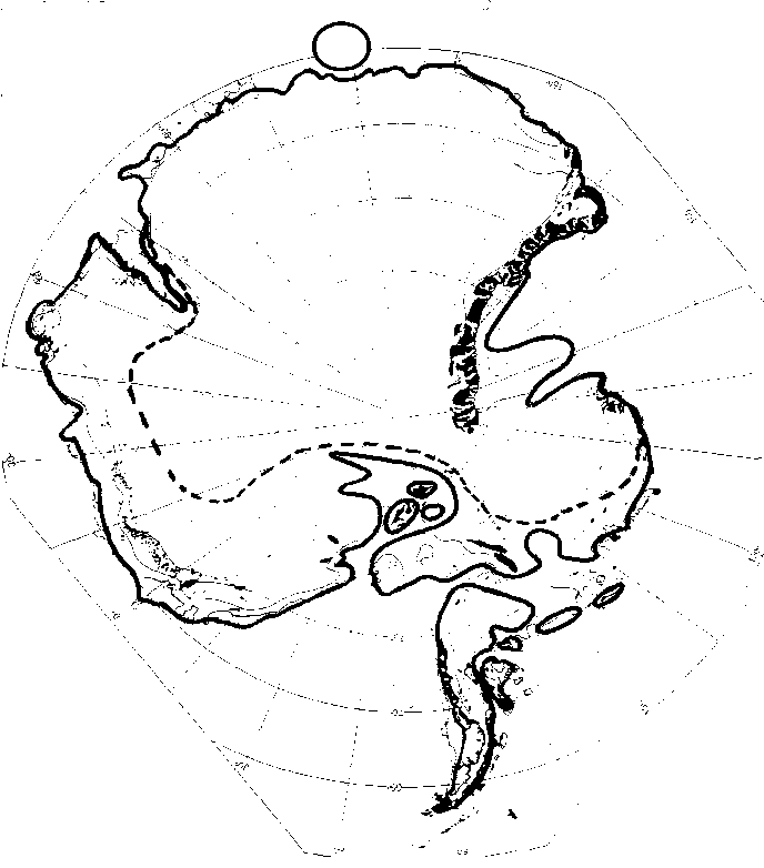
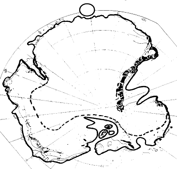
From a modern map of Antarctica where the thickness of the ice cap is reported point by point, it is possible to draw a map of the island as it was at the end of Pleistocene, when the Atlantic coasts were ice free and the sea level lower than today. Of course, we have to orient the map with the South Pole on top, as it was mandatory for geographer living in the southern hemisphere (Figure 11).
- Starting from the top left we have a deep inlet, with a particular profile, corresponding to Mackenzie Bay
- On the top right we have a large gulf, also with a particular profile, corresponding to the Ross area.
- At the bottom, the Peninsula was slightly detached from the main continent, and right at the centre a narrow entry introduced in a wide internal basin, analogous to our Mediterranean, which stretched well inside the continent, reaching the ice cap expanding from the inland.
Let’s imagine, then, what a medieval monk would have thought, finding amongst the papers of his archive a map of this kind, of unknown origin. Its geographical meaning was clear; and the representation was perfectly in agreement with the ancient classic descriptions of the world as an island surrounded by the “river ocean”. So obviously he had to think that it represented the entire world. He had to reproduce the map, identifying on it the various geographic entities of which he was aware: the Mediterranean and around it Europe, Asia and Africa.
In his “source map” the Mediterranean was at the bottom of the map; therefore, he moved the north on the left. This clearly betrays the existence of a model to which he had to remain faithful. There is no other logical justification for this fact.
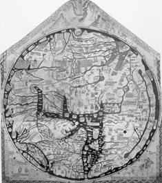
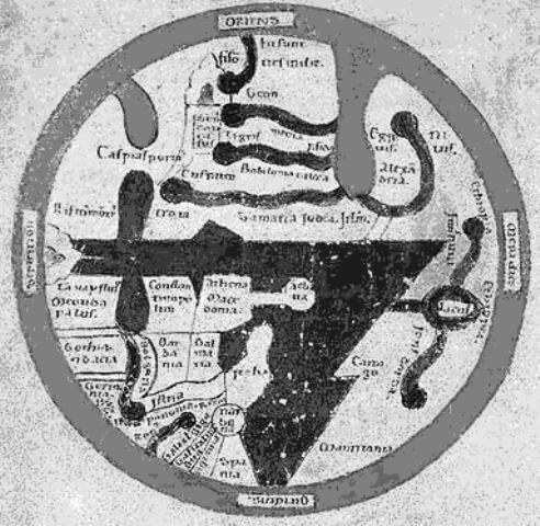
This representation passed from one monastery to another undergoing modifications and simplification in this process, ending up on one side to the extremely stylised O-T planispheres, on the other end to very sophisticated geographical representations, like that of Fra Mauro, which represents the Mediterranean and adjacent seas in a faithful manner, still maintaining the essential characteristics of the primitive model. Let’s then compare some typical planispheres with the pleistocenic Antarctica (in the picture
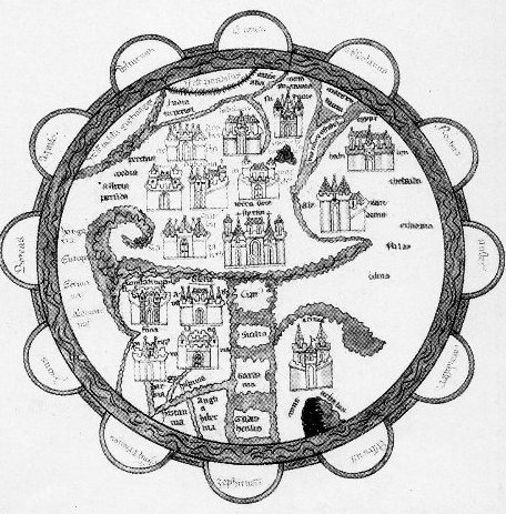
the planispheres of Pomponio Mela, Saint Denis, Higden and Vesconte) (Figure 12).
Even from a very superficial examination it is evident that they all respond to the same basic model, all of them have the north on the left; a Mediterranean at the bottom-centre, very schematic, with no relation with the real one; a deep inlet on the top left and a large gulf on the top right with a unique profile. Exactly as the representation of pleistocenic Antarctica.
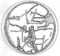
Many planispheres, like for example those due to Hereford and Sawley, besides responding to the same basic model, represent a small circle on the top of the map, on the same position of the South Pole in the Antarctica of 11 thousand years ago (Figure 13 & 14).
Antarctica in the Maps of Mercator and Finaeus
But what about the Peninsula? Although separated from the main continent, it should have been drawn in the hypothetical “source maps”. Professional geographers like Finaeus and Mercator, who, according to Hapgood, were inspired by the same source map, couldn’t ignore the existence of the Peninsula in their representations.
As a matter of fact, they didn’t. The geographical nature of their “source map” had to be clear, but it did not match with any land they had knowledge of. It must have been the “island” Peninsula that gave them the clue were to place that not yet discovered land. They had to think that the peninsula
represented the tip of South America, that was reached by Magellan only a few years before, on 1519. From the evidence they had, on the other side of Magellan channel there had to be a large continent, undoubtedly that mysterious land represented in their source map, which couldn’t find any other location in the world. They had to adjust the scale of that representation in order to merge the Peninsula with South America.
The result: an Antarctic continent out of scale, with its profile faithfully reproduced, as demonstrated by Hapgood analysis. Even the Peninsula is represented, but “merged” with the tip of South America (Figure 15).
Conclusion
Geologists explain the existence of the immense icecaps that at the end of Pleistocene covered most of North America and northern Europe with a drop of temperature, denying that the poles were on a different position. A denial that entails an implausible explanation to. The fact that they are not able to explain how and why the poles can shift does not justify their refusal to recognize that this was in effect the most probable cause that provoked the end of Pleistocene, throughout phenomena that were lethal for both for man and nature.
In doing so, they not only deceive themselves and the general public on an issue of extreme importance for humanity, but they deny historians and archaeologists the possibility to understand how, where, and when the first human civilization arose, and how and from where it spread around the world. No scholar today is able to provide an answer to these questions. Despite the evidence that all ancient civilisations present a common background, it seems that they arose autonomously in South and Central America, in China, Indochina, India, Mesopotamia and in the continental platforms where archaeologists continue to discover new traces of unknown developed societies. It does not make sense.
The answer can be found in the Atlantis scenario. The eccentric northern polar ice caps prove that also the south pole was in a different position and that the geographical and climatic situation in the southern hemisphere was as described in this scenario. At first sight it looks disconcerting, but there is no credible alternative in view of the available evidence.
The ultimate proof, the archaeological one, is missing so far (at least on my knowledge), but it would not be too difficult to find it. Somewhere, probably under the Filchner Ice Shelf, east of Berkner Island, there might be the ruins of an immense city discharged into the sea by moving ice. The first to find them will give a definitive answer about the end of the Pleistocene and will open to historians and archaeologists the possibility of finally shedding light on the past of human history, that has so far remained completely obscure.
References
-
Sacks VN, Belov NA, Lapina NN (1955) Our present concept of the geology of central Artic. Priroda 44: 13- 22.
-
Mulvaney R, Alemany O, Possenti P (2007) The Berkner Island (Antarctica) ice-core drilling project. Cambridge University Press.
-
Coleman AP (1929) Ice Ages recent and Ancient. Mac Millan, USA, pp: 296.
-
Almond M, Cleg JA, Jager C (1956) Rock Magnetism. Philosophical Magazin.
-
Ting M, Ying H (1952) Research on the past climate and continental drift. Columbia university, Taipei.
-
Bain GW (1963) Climatic Zones throughout the Ages. In: Munyan AA (Ed.), SEPM Special Publication 10.
-
Trevisan L (1953) Corso di Geologia. Pisa University, Sala delle Stagioni pp: 383.
-
Di Leland McInnes. Radiativeforcings.svg. Creative Commons AttributionShareAlike 3.0 Unported. Wikimedia Commons.
-
Clerk MJ (1890) On a dynamical Top. In: Niven WD (Ed.), Cambridge University Press 1.
-
George D (1876) On the influence of geological changes on the Earth axis of rotation. Philosophical transaction of the Royal Society.
-
Hapgood C (1970) Path of the North Pole. Chilton Book Philadelphia pp: 413.
-
Benioff H (1951) Global Strain Accumulation and release as revealed by great earthquakes. Bulletin of Geological Society of America.
-
Casey M (2015) Scientists Debate Evidence of Ancient Megatsunami - Giant tsunamis may have helped to shape the world around us today. National Geographic.
-
Hallam A, Wignall PB (1977) Mass extinctions and their aftermath. Oxford University Press.
-
Marusek JA (2007) Comet and Asteroid Threat Impact Analysis. Impact Bloomfield.
-
Gallen FL (1950) Calculation of the stabilizing centrifugal effect of the equatorial bulge of the Earth. Commerce U.S. Coast and Geodetic Survey.
-
Barbiero F (1995) On the possibility of very rapid shifts of the poles. Quaderni di Matematica Bergamo University.
-
Barbiero F (2023) Earth an unstable planet – Why and how the Poles can shift. CTES 3(1).
-
Spedicato E, Barbiero F (2022) Beyond Einstein one dimensional approach to special Relativity. WriteUp Books.
-
Barbiero F (1974) A Civilization Under Ice. Mind, Body & Spirit.
-
Barbiero F (2023) The Unit of Time and the Mesoamerican Calendar. Graham Hancock Official Website.
-
Hapgood CH (1966) Maps of the Ancient Sea Kings. Kempton Illinois.
- Asymmetry Irreversible Heterogeneity Quantum Cosmology Grand Mathematical PHYSICS
- Early Universe: Hadronic Crystals Coherent Micro Gravitational Wave Emitters PHYSICS Part II
- The Solar System Constraint Maze: A Scientific Dead-End Revealing the Interuniversal Machine
- Assessment of Radiofrequency Radiation from 2G and 3G Mobile Phone Handsets
- Early Universe Magneto-Gravitational Coupling Genesis Physics: Part I
- Falsifiability of the Classical Law of Gravitation and Unveiling the Time-temperature Entanglement of the Universe