Evaluating the Reservoir Quality of the Darian Formation Using Well Logs: A Case Study of One of the Offshore Oil Fields in the South Pars Oilfield
The current paper aims to examine these parameters for evaluating the reservoir quality Darian Formation situated in one of the South Pars hydrocarbon fields. Also, zoning of the Darian Formation sequence is conducted for this reservoir. The average petrophysical parameters calculated in the Darian Formation sequence, including shale volume, total porosity, and water saturation, are 0.21%, 20.91%, and 81.6%, respectively. Based on these values, the sequence of the Darian Formation is divided into eight different zones. Zone 4 showed the highest reservoir quality, with a depth of 2367 to 2384 meters and a porosity of 22.8%, has the highest porosity, lowest water saturation of 37.1%, and about zero Shale volume. Zone 1 showed the weakest reservoir quality, with a depth of 2337 to 2353 meters and a porosity of 13.6%, has the lowest porosity, water saturation was about 89.19%, and about 5% Shale volume. Furthermore, neutron-density, MID, and M-N cross plots combined lithology in the Darian Formation sequence for calcite, quartz, dolomite, and limestone, and low amounts of shale in the well are identified.
Introduction
One of the significant raw materials that are the primary need of countries and industries nowadays is oil [1, 2]. Clearly, hundreds of things are made from petroleum and used with various applications in industries and devices. Also, oil and natural gas are employed in many products like lipstick, deodorant, and life-saving medical devices. One of the vital challenges in this regard is the extraction process that must be conducted efficiently to reach the desirable results. Hence, the study in this field is of great importance [3, 4].
The oil and gas produced today are mainly stored in reservoirs of sandstone, limestone, or dolomite [5, 6]. The amount of oil or gas per unit volume of a reservoir is equal to the amount of porosity in the reservoir rock multiplied by the hydrocarbon saturation in the porosity of this rock. In addition, the formation volume containing the hydrocarbon is also required to calculate the total storage capacity of the reservoir. Therefore, the reservoir’s thickness is one of the fundamental parameters for obtaining the tank’s volume. Notably, petrophysical properties [7] such as porosity, fluid saturation, and shale volume play a prominent important role in the efficiency of the hydrocarbon reservoirs [8, 9]. When these parameters are calculated accurately, the exploration risk and production and exploration costs are significantly reduced. Besides, the wells’ production increase considerably, and the efficiency is maximized through more effective production methods. More than fifty percent of the oil and gas reservoirs in the world belong to carbonate reservoirs [10]. Notably, the majority of the Iranian hydrocarbon fields in the Persian Gulf Basin and the Zagros Folded-Thrust Belt are the main sources of this category of reservoirs. Asmari, Ilam, and Sarvak limestone formations are the place of crude oil accumulation for an amount of about 95% [11]. The primary Iranian oil reservoirs are constituted of Carbonate. The oil and gas reservoirs are likely to be fractured during the regional tectonic activities in Iran [12]. On the other hand, the regularly spaced fractures and fault sets are the vital factors of the complicated reservoirs in production, trapping, and fluid flow. Overall, the lifetime of a hydrocarbon field [13] is divided into five steps, namely, the exploration phase [14], the appraisal phase [15], the development phase, the production phase, and decommissioning phase. When an exploratory well hits a hydrocarbon, considerable effort is still required to determine the field’s storage space. In other words, no information regarding the actual field storage or the productive capability of accumulated hydrocarbons is obtained in the exploration phase. The main concern is that a field may produce hydrocarbons more or less than what is expected. Hence, proposing an evaluation plan is required to optimize the technical development. This evaluation eliminates the ambiguity in the hydrocarbon reservoirs’ definition, predicts the reservoirs’ performance during production, and makes reasonable decisions concerning starting or stopping activities or handing over exploration. The main tools employed in the evaluation are the same tools considered in the exploration phase. These tools depend on what kind of ambiguity the evaluation phase is trying to reduce and what information is required for this purpose. The major parameters playing a prominent role in information evaluation are as follows: porosity [16], permeability [17], the water-oil contact surface [18], gas-oil contact surface, initial water saturation [19], primary gas saturation, primary oil saturation, thickness [20], type of reservoir rock [21], reservoir pressure [22] and the damage’s intensification for the formation in drilling operations. For instance [23] aimed to investigate the mineral composition, microstructure, porosity, and permeability properties of the reservoir formation employing deep-water reservoir cores from the western South China Sea [23]. Then, conducting the core flow experiments, the potential fluid sensitivity was analyzed to specify how and which fluids are able to damage the reservoir formation in the process of drilling. Two categories of open-hole [24, 25] and cased-hole logs [26] are considered in wellbore drilling science. Open-hole logs are recorded in wells without casing, and cased-hole logs are recorded in wells with casing. Open-hole logs are usually used to determine the petrophysical properties of the reservoir. Hence, the experts combine the information from different logs and create mathematical equations to reach this aim. It should be noted that the novel cased hole logs presented recently can measure some of the physical properties of the reservoir even in the back of the casing, such as resistivity, which is one of the basic parameters in determining the petrophysical properties of the reservoirs. In the process of formation examination, various information and data can be employed to explore the hydrocarbon resources that are obtained through a variety of exploration techniques. The physical properties of the well wall are measured using a so- called tool sonde.
Well-logs provide valuable and indirect information regarding the mineralogy, texture, sedimentary structure, fluid content, and hydraulic properties of the reservoir. Hence, a large number of existing studies in the broader literature have presented many logs such as Gamma Ray Osarogiagbon AU, et al. [27], Sonic (DT) He J, et al. [28], Neutron Porosity (NPHI) Wraighte P, et al. [29], Bulk Density (RHOB) Gowida A, et al. [30], Photoelectric (PEF) Moradzadeh A, et al. [31], and Resistivity Logs Osarogiagbon AU, et al. [32] to reach the most efficient results. For instance, Mauborgne ML, et al. [33] used Gamma Ray Log in designing nuclear tools for oil exploration and considered nuclear modeling for concept evaluation and initial specification [33]. In fact, the well-logging technique is employed to specify the petrophysical properties such as porosity, permeability, and fluid saturation of subsurface formations. Nevertheless, the conventional method of log assessment is significantly expensive and tedious. For this reason, Joshi, et al. presented a new technique to specify the properties of drilled formations and anticipate sonic logs [34]. This new technique was introduced considering a regression method and a supervised machine learning (ML) algorithm. Besides, a clustering and a neural network method were utilized based on gamma-ray log values, and a relationship was created between them. The proposed model presented an acceptable result with suitable accuracy, according to which siltstone, coal, and sandstone are divided into five clusters. In 2018, a study was conducted to examine the mechanical parameters of a turbiditic reservoir in Campos Basin–southeast Brazil [11]. The Photoelectric (PEF) log is a suitable log widely used for lithological identification. This log has a dual variability in the broken zones. When the fractures in the fractured zone are semi-closed or closed, and the drilling mud cannot penetrate into the fractured zone, the PEF will show a relative reduction. The main reason is that the atomic number of particles in porous water is smaller than in rock. Nevertheless, if the fractures are open and the pressure of the drilling mud is higher than the pressure of the formation, the mud will penetrate into the fractures.
The petrophysical evaluation is conducted in two ways, namely the deterministic method and the probabilistic method. The former is known as an old method that evaluates the petrophysical parameters step by step. In comparison, the latter is based on modern techniques and statistical probabilities. The probabilistic method is more welcome since it is presented using available logs and mineral models. The random errors in this method are less than they used logs; however, its solutions depend on the mineral model and weight parameters. The current study aims to process and interpret well logs, calculate the petrophysical properties of the hydrocarbon reservoir for one of the wells situated in the hydrocarbon fields of the South Pars, and examine the main parameters affecting reservoir quality. The existing geological and wells data are investigated by collecting reports, papers, and library studies associated with Darian Formation. Petrophysical processing and interpretation of raw data obtained from well-logging are analyzed to evaluate the reservoir quality of the Darian Formation. This study considers the calculation of the Darian Formation sequence’s porosity, water saturation, shale volume, and zoning. To the best of our knowledge, no study to date has yielded the results obtained in this paper. The findings are beneficial to those aiming to study in the field of petroleum exploration and production technology and are of great importance in terms of cost reduction and efficiency increase.
The rest of this paper is organized as follows: The methods and tools and the type of log considered in this study are presented in the second section. The third section gives the necessary information regarding the petrophysical parameters considered to assess the quality of the reservoir, and some related equations are given in this section. The results obtained from the analysis are illustrated in the fourth section. Finally, the conclusions and suggestions for future study are drawn in the fifth section.
Methodology
The methods considered to analyze the problem of this study are outlined in this section. The probabilistic method is employed since it has a single solution with constant analytical parameters. And the PEF log is considered to assess the quality of one of the hydrocarbon reservoirs situated in the South Pars. Using Geolag software, the petrophysical evaluation is conducted, and the results are presented in the next sections.
The Photoelectric (PEF) Log
According to modern technology and novel instruments in this regard, low-energy gamma rays are also measured as well as density. Low-energy gamma rays depend on the photoelectric absorption factor of the formation. When the gamma-ray is absorbed by the electron bound to the core and the energy transmitted by the gamma-ray is greater than the atomic energy to bind the electron around itself, it is obvious that the electron moves in this situation. Also, this electron emits an X-ray with energy based on the atomic number of the material. For the materials with higher atomic numbers, this phenomenon is likely to occur in gamma rays. The photoelectric effect is considered in this PEF log, according to which the photoelectric absorption factor $(P_e)$ is measured. This factor is defined by $(Z/10)^{3.6}$ and has a minor impact on fluids with low atomic numbers. This log represents the rock matrix, and $P_e$ measurement is the main lithological index, especially for carbonated formations. The parameter $P_e$ varies between 1 to 6, and for the main three minerals, quartz, dolomite, and calcite, this value is 1.8, 3.1, and 5.1. Besides, the PEF log can be employed for specifying the fractures and sedimentary environment. Most early studies, as well as current work, focused on this log and obtained remarkable results.
The Petrophysical Parameters
The purpose of wellbore surveying is to measure petrophysical and geological parameters. Unfortunately, in most cases, the desired parameter cannot be obtained directly from the log. A well-drilling environment refers to the whole factors around the sonde that affect the response of the tool. Some of these factors, such as temperature and pressure, are normal, and others are caused by drilling mud. The main factor playing a prominent role in this regard is illustrated in this section.
The temperature of the formation increases based on the depth. The amount of temperature increase with increasing depth is called the geothermal slope. Formations that have high thermal conductivity have a low geothermal slope and vice versa. Equation 1 represents this slope which is very important for well-logging.
$$G = \frac{(T_{Bottom Hole} - T_{Surface})}{Total Depth}$$
In addition to the direct effect on well drilling tools, the pressure is effective on most parts of the formation that participate in the log response. Also, the pressure affects the mechanical properties of the material. For instance, a rise in pressure increases the density of drilling mud, the density of rocks, and the speed of elastic waves. The pressure in the formation can be divided into three categories: lithostatic pressure, hydrostatic pressure, and effective pressure, which is the difference between the values of lithostatic pressure and hydrostatic pressure. Lithostatic and hydrostatic pressures are calculated through Equations 2 and 3 that are shown below:
$$P_{Lithostatic} = \frac{H \times p_m}{10}$$
According to Equations 1 and 2, the lithostatic pressure results from the solid part of rock and depends on the formation density. Hydrostatic pressure is the pressure caused by fluids, and its value is a function of fluid density and depth.
It should be noted that the larger the diameter of the well, the larger the volume of mud around the sonde, and ultimately the greater its impact on the log. If the diameter of the well is very large, no signal from the formation may reach the receiver. Besides, drilling mud plays a prominent role in specifying which log is suitable for a particular well. For instance, it is not possible to consider acoustic measurement and strength for the empty wells since the air has a remarkable strength against electric currents and does not direct the acoustic waves accurately. Strength logs in salt muds respond well, but induction logs cannot be used instead. Oil-based or water-based muds with medium strength are suitable for induction logs. In addition to drilling mud, other parameters of mud such as density and hydrogen can affect the logs. The tools that stick to the wall of the well, such as SNP, LDT, FDC, MSFL, ML, MLL, and PL, minimize the effect of drilling mud. The drilling mud needs to be corrected for other logs. The main parameters of drilling mud are density and specific strength. Measuring these parameters and calculating them in terms of pressure and temperature for each depth is necessary. Also, other parameters such as mud clay, mud filter, cement, and casing have a profound impact on the well logging.
Reservoir Quality Evaluation of Darian Formation
The purpose of the petrophysical evaluation is to examine the relationship between the physical properties of the rock and the fluid within it. Also, the petrophysical parameters such as porosity, shale volume, and saturation are calculated to prepare a petrophysical and static model. The oil and gas produced nowadays are often obtained from the pores of the reservoir rocks in which these fluids have accumulated. The amount of oil or gas per unit volume of a reservoir is calculated by multiplying the porosity by the amount of hydrocarbon saturation. The rock’s porosity represents the percentage of the total volume of the rock occupied by the pores and cavities. Hydrocarbon saturation is also defined as the percentage of porosity volume that is filled by hydrocarbons. This section calculates the petrophysical parameters, including porosity, shale volume, and water saturation. Then, by zoning each area according to the obtained petrophysical parameters, the quality of the reservoir is evaluated.
Porosity Calculation
Porosity is one of the most important properties of the rock, which depends on the capacity and volume of hydrocarbon accumulation in the rock. Overall, in petrophysical studies and petroleum engineering, the total porosity includes the whole pores, such as porosity between the matrix constituent particles, saturated porosity by the water adhered to the particles, and porosity of shales and clay minerals. The primary purpose of logs analyses is to determine the fraction of pores filled by hydrocarbons. The main steps that need to be considered for porosity calculation are environmental corrections, hydrocarbon correction, shale correction, and finally, the porosity is obtained.
According to the density log, the amount of porosity in the formations is calculated through Equation 4.
$$\varphi_{Density} = \frac{\rho_{ma} - \rho_{b}}{\rho_{ma} - \rho_{f}}$$
Where the density of the rock matrix is, is the total density of the rock, and is the fluid density inside the formation.
The following equation performs shale correction for the porosity obtained from the density log:
$$\varphi_{core} = \varphi_{Density} - V_{sh} \varphi_{sh}$$
Specifying the Water Saturation and Hydrocarbon in Darian Formation
In order to calculate the water saturation of clean formations, the relation proposed by Archie GE, et al. [35] is used, which is shown below:
$$S_w = \sqrt{F \times \frac{R_w}{R_t}}$$
$$F = \frac{a}{\varphi^m}$$
According to Equations 6 and 7, is the water saturation, is the specific strength of the formation’s water, denotes the actual strength of the formation, and F is the formation coefficient. is the constant coefficient (which is equal to one for carbonates, 0.062 for non-dense sandstones, and 0.81 for dense sandstones). m represents the cementing factor of the rock (which is 2 for the dense sandstones and carbonates and 2.5 for non-dense sandstones) [36]. Due to the presence of shale in the formation under examination and correction of its effect, the following equation is used to calculate water saturation:
| v sh R sh | v 2 ϕ2 sh R 0.2R 1V R sh w sh t |
|---|
(8) ϕ ( )
0.4 1 R V $$ 4 \times R _ {w} \times (1 - l $$
w sh Where sh V represents the shale volume and sh R denotes the specific strength of the depth in the 100% shale layer.
The Shale Volume Calculation
Shale volume is one of the most basic parameters to be calculated in petrophysical and reservoir quality studies. The electrical properties of clays have a remarkable impact on the calculated resistivity of well drilling logs. In addition, shale and clay minerals will have a noticeable effect on the calculation results of the reservoir’s porosity, permeability, and water saturation due to the small porosities (in the particle). Hence, the volume shale needs to be calculated in the reservoir and considered in the petrophysical parameters. In this research, the CGR method is employed to evaluate the shale volume accurately, which is calculated through Equation 9:
$$ V s h = \left(C G R _ {l o g} - C G R _ {m i n}\right) / \left(C G R _ {m a x} - C G R _ {m i n}\right) \tag {9} $$ In order to determine the average Gamma ( min CGR ), thoroughly shale-free distances, and maximum Gamma ( max CGR ), the complete shale layers are selected. log CGR Represents the Gamma log’s reading in the depth in which the shale volume is calculated.
Results and Discussion
In this section, the reservoir quality of the Darian Formation is assessed using well logs in one of the South Pars hydrocarbon fields. The South Pars is located on the northeastern edge of the Arabian Peninsula between latitudes 24° to 30° N and longitudes 48° to 57° E. The South Pars, with a length of 1000 km and a width of 200 to 300 km, has an area of approximately 226,000 square kilometers. The average water depth is 35 meters, and the maximum depth is about 100 meters [37].
Darian formation situated in the South Pars’s drilled wells is considered the Shoaiba Formation in Saudi Arabia and Kuwait. During the early Aptian period, rising sea levels led to the deposition of shallow limestones of Darian. The lithology of this formation consists of three parts defined as follows:
- Upper Darian: It is mainly composed of gray limestones to intraclasts brown limestones.
- Kazhdumi Tongue: There is a shale section in the middle part of the Darian Formation, which is considered the Kazhdumi tongue. These shales are primarily black, sometimes silty. Thin layers of brown to gray limestone can be seen between these shales.
- Lower Darian: This section contains brown to gray and fossil limestones which probably have some cherts.
Quality Control and Data Editing
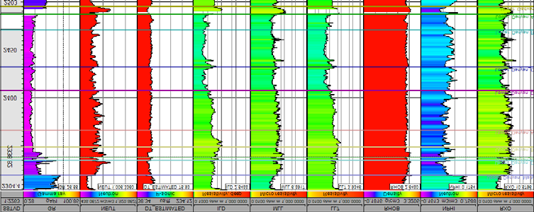
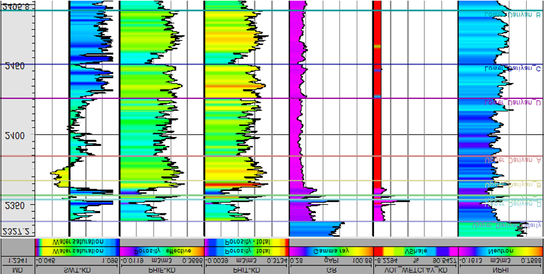
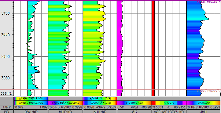
To evaluate the petrophysical parameters, the petrophysical project called the petroleum field studied in the Geolag software is defined in the main menu. Then, the raw data of the well-logging and information regarding the studied wells are stored in its database to conduct the preparation steps. Figure 1 shows some logs available in Darian Formation the well-considered in this research. The Gamma, Neutron, Sonic, ILD, MLL, LL7, RHOB, NPHI, and RXO logs are highlighted in this (Figure 1).
In petrophysical evaluations, the initial logs are raw, and quality control and editing steps are performed. In the second stage, the combined logs of each well that are digitally loaded in LAS format are inserted and displayed graphically and curved to fulfill their quality control. The well logs are considered to specify the petrophysics, geology, and reservoir modeling according to basic standards. Hence, the unrelated and additional logs are removed or placed next to related logs since the number of logs in a column (Track) may be significantly large and causes error and confusion for the user. It should be noted that the linear or logarithmic scale of the logs and the standard colors of the logs are determined based on the set standards. This step is considered in the Layout section.
Depth Matching and Smoothing
In the process of logging, due to the cable tension, the layers’ slope, the different depths of examination, and the vertical accuracy of logging tools, the depth is likely to be different between the various logs. In this case, one log is selected as the base log, and other logs are given depth matching if necessary. To consider depth matching in the Geolag software, the manual depth shift is used. For this purpose, a particular log is considered the base log, and the other logs replace each other according to that log. In this study, the neutron log is considered the base log for depth matching with different logs.
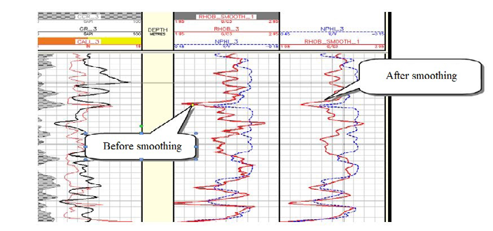
The smoothing option is employed to eliminate the reading noise on some logs. The diagnosis of this anomaly depends on the user experience, and this problem is often observed in the DT, RHOB, and MSFL logs. The smoothing process is conducted on these logs to minimize errors in evaluation and calculation. Four methods are defined for smoothing in the Geolag software, including MEDIAN, HARMONIC, GEOMETRIC, and MEAN. The MEAN method is commonly used for smoothing. The path to obtaining smoothing options for logs in Geolag software is as follows:
- Well → General→ Log Edit → Smooth → Log in → RHOB
- Log out → Rhob_Smooth The smoothing results on the density log are illustrated in Figure 2. Besides, when there is slice skipping in the sonic log, this log is corrected in the spike removal step. The following path must be considered for this operation:
- Well → General→ Log Edit → Despike → Log in → DT
- Log out → DT_DESPIKE
If necessary, other operations such as baseline shifting, splitting and merging the logs, and log reconstruction are considered.
Determining the Unsuitable Conditions in the Well and Environmental Corrections
The Logs recorded at depths of the well containing melting and fracture lack the required reliability and authenticity in terms of usability. Through the use of diameter logs and density differences, it is possible to specify the unsuitable conditions for the wells. When the density difference (DRHO) log is out of range of -0.1 to 0.1 g/cm3 and the difference of diameter log and well drilling diameter is more than inches, the desired depth is regarded as Bad Hole.
Cal – Bs >1/5 Inch → BHF
Considering the well’s poor conditions, the log’s reading ability encounters an error in the specific range that must be specified in the quality control phase.
The environmental corrections of well drilling logs are considered to approach the reading status of logs and the main features of the formation and fluids in it and eliminate the unnecessary factors on the logs, such as mud. Every factor around the log affecting the log’s response, like temperature, pressure, and the well’s diameter, is regarded as the well environment, which is inherent. Some factors resulting from drilling mud and hydrocarbons may not be the same anywhere. The drilling mud’s effect depends on the physical and chemical parameters of the fluid. The parameters such as the mud type, concentration, type of salt (NaCl, KCl, CaCl2), weight gain materials (barite, fermentation, etc.), strength, density, hydrogen index, GR, DT, etc. can affect the log response. In the sequence of Darian Formation, using the information obtained from the precalc phase and other information of the well, the available logs have been corrected based on the correction logs of the logging companies. Also, the effects of the wellbore conditions are eliminated from the log reading to make them more appropriate for the real conditions of the formation. Figure 3 highlights the logs correction in the sequence of the Darian Formation.
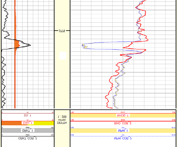
According to (Figure 3), the minor effect is observed on the logs, and only in a part of well sequence, the diameter log of the well shows a slight melting. The reading after corrections slightly differs from the reading of the initial or raw log. Lithology The information regarding the constituent minerals’ conditions and the type of sequence rock of the reservoir formation can be employed to identify the general condition of the reservoir to some extent. Most of the methods proposed in lithology science are employed, assuming that some lithologies are known. Overall, at least two logs are needed to estimate the lithology. Different cross-plots, including neutron-density, neutron-sonic, density-sonic, and density- photoelectric, are employed to identify lithology. Using these cross-plots, at most, two mineralogical compounds can be identified.
Lithology is a vital phase in assessing the reservoir properties and can be advantageous to separate areas containing reservoir quality from the area without reservoir quality. In quantitative analysis, several reasons justify the need to have information concerning lithology. One of these reasons is that the formation coefficient and the variables used in the Archie water saturation relationship vary based on lithology. The water is saturated, and the required parameters in calculating these factors are Δt and ρma. It is necessary to design an appropriate model in the multi-mine method considering the lithology and the formation’s fluid information. Nevertheless, it is impossible to determine the formation lithology with reliability based on the logs. Hence, the data from well drilling’ logs need to be combined with other sources of lithology such as drill cuttings and drill core to determine lithology accurately.
In the research projects, various methods are employed for lithology identification after environmental corrections and parameter picking. In this study, the lithology of the Darian Formation is identified by the well drilling logs and standard cross plots, which are presented as follows.
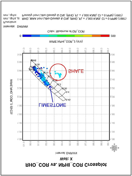
Identifying Lithology by Density-Neutron (RHO-NPHI) Cross-Plot: This cross-plot is employed to identify the lithology as well as determine porosity and distinguishes sand lithologies accurately from dolomitic and calcareous lithologies. It should be noted that before using this cross- plot, the data must be corrected for shale and hydrocarbon separation. Figure 4 indicates the density/neutron cross-plot for a sequence of Darian Formation in the well under study. The binary plots presented in this figure show that these data mostly indicate the presence of lime, and a small amount of these data represent the amounts of clay minerals (shale). Therefore, the combination of lithology for the sequence of the Darian Formation in this well consists of lime and a few clay minerals.
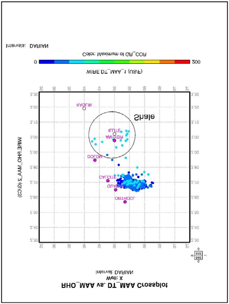
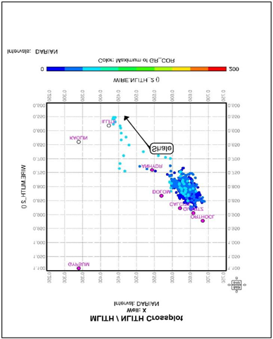
Identifying Lithology by MID Cross-Plot: In order to identify lithology more accurately, the MID plot can be used, which determines the matrix Δtmaa – ϕNmaa – ρmaa. After calculating the parameters ρmaa and Δtmaa, it is possible to use them in the MID plot. The MID plot has remarkable advantages over the M-N plot since significant parameters, namely density and Δt, are considered in this plot. Whereas the parameters M and N have only a slope in the M-N plot.
Due to the scattering of data around the points associated with the minerals identified on the plot, lithology is predominant in the lime well since data scattering is observed around the point related to calcite. As shown in Figure 5, the colored label at the bottom of the plot implies the fact that the amount of shale in the well is significantly low.
M-N Cross-Plot: The M-N cross plot used for identifying lithology considers three porosity logs. In fact, the cross plot is used to eliminate the porosity effect and obtain the ternary mineralogical composition. Through Equations 10 and 11, M and N are calculated.
Ä Ä − = × −
t t M ρ ρ
0.01 f (10) b f − = −
b f N ϕ ϕ Nf N
(11) ρ ρ
One of the unique capabilities of this plot is to identify secondary porosity since it changes the secondary porosity of M but has no effect on N. Data scattering in this plot is identical to the MID plot shown in Figure 6.
The Results of Reservoir Quality Evaluation of Darian Formation
Using Equations 1-9, the petrophysical parameters calculated in the Darian Formation are obtained, highlighted in Figure 7.
The primary purpose of petrophysical evaluation and formation evaluation is to analyze the hydrocarbon zones and examine their reservoir quality. In this phase, the zoning process is performed based on petrophysical parameters in the Darian Formation sequence, and each zone’s relative quality is presented according to petrophysical parameters.
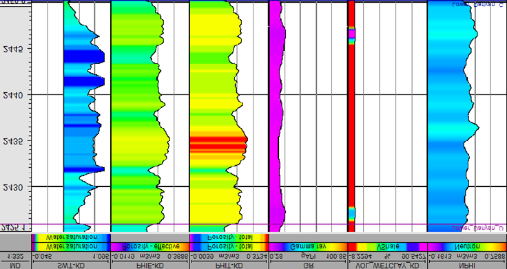
Zone 1 (2337-2353 Meters): The porosity and water saturation in this zone are about 13.6% and 89.19%, respectively. The shale volume is approximately 5%. Figure 8 indicates the variations in porosity, water saturation, and shale volume in this zone, according to which the average porosity is the lowest porosity among the whole zones. Also, the water saturation is relatively high, and consequently, this zone can be considered the weakest reservoir zone of the Darian Formation.
Zone 2 (2353-2356 Meters): The thickness of this zone is about 3 meters, and its porosity and water saturation are 19.7% and 43%, respectively. The shale volume is about 6%. Figure 9 outlines the variations in porosity, water saturation, and shale volume in this zone. According to the parameters calculated in the Darian Formation sequence, the quality of this zone can be evaluated accurately.
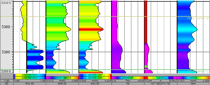
Zone 3 (2356-2367 Meters): The thickness of this zone is about 11 meters, and its porosity and water saturation are 15.8% and 56.8%, respectively. The shale volume is close to
1.5%. The variations in porosity, water saturation, and shale volume in this zone are highlighted in Figure 10.
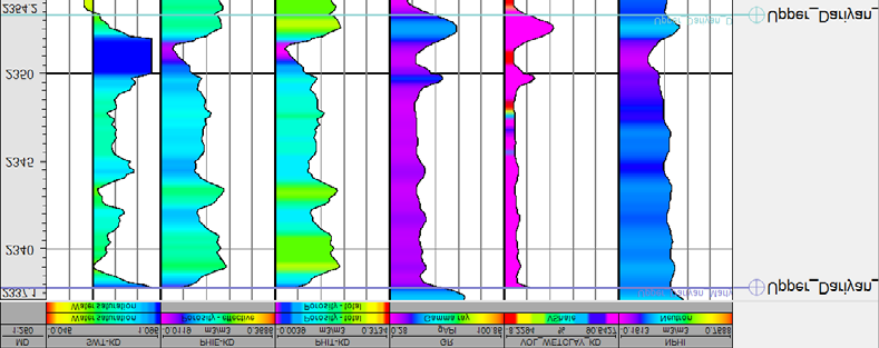
Zone 4 (2367-2384 Meters): The thickness of this zone is about 17 meters. The average porosity and water saturation in this zone are 22.2% and 37.1%, respectively, and the shale volume is about zero percent. Considering that this zone has the highest average porosity, the lowest water saturation, and lack shale volume, this can be regarded as the best reservoir zone of the Darian Formation. Figure 11 shows the variations in porosity, water saturation, and shale volume in this zone.
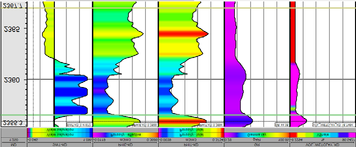
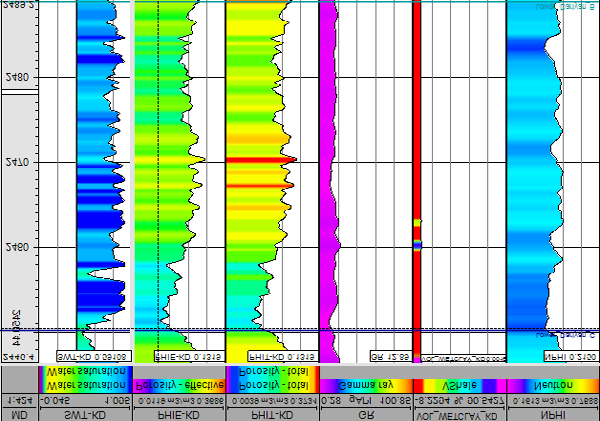
Zone 5 (2384-2624 Meters): The thickness of this zone is about 79 meters, and its average porosity and water saturation are 19.15% and 57.26%, respectively. Notably, the shale volume in this zone is close to zero percent. Figure 12 illustrates the variations of porosity, water saturation, and shale volume in this zone.
Zone 6 (2426-2450 Meters): The thickness of this zone is about 24 meters, and its average porosity and water saturation are 22.6% and 8.02%, respectively. The shale volume in this zone is virtually one hundred percent. Figure 13 shows the changes in porosity, water saturation, and shale volume in this zone.
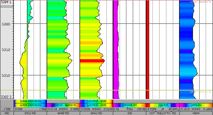
Zone 7 (2450-2489 Meters): The thickness of this zone is about 39 meters. Accordingly, this zone’s average porosity and water saturation are 20.6% and 87.57%, respectively. Besides, the shale volume of this zone is close to two hundred percent. Figure 14 represents the changes in porosity, water saturation, and shale volume in this zone. This zone has the highest amount of water saturation among the zones of the Darian Formation.
Zone 8 (2489-2505 Meters): The thickness of this zone is about 16 meters, whose average porosity and water saturation are about 20.9% and 81.6%, respectively. The shale volume in this zone is about two-tenths of a percent.
Figure 15 shows the changes in porosity, water saturation, and shale volume in this zone. This zone has the highest amount of water saturation among the zones of the Darian Formation.
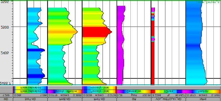
Table 1 gives brief information regarding the results obtained from the analysis conducted in this study for Zones 1-8.
| Zone | The average shale volume (Percent) | The average porosity (Percent) | The average water saturation (Percent) | |
|---|---|---|---|---|
| 2337-2353 | Z1 | 5.07 | 13.6 | 89.19 |
| 2353-2356 | Z2 | 6.35 | 19.7 | 43 |
| 2356-2367 | Z3 | 1.41 | 15.8 | 56.8 |
| 2367-2384 | Z4 | 0.0016 | 22.8 | 37.1 |
| 2384-2426 | Z5 | 0 | 19.15 | 57.26 |
| 2426-2450 | Z6 | 0.094 | 22.6 | 81.02 |
| 2450-2489 | Z7 | 0.0264 | 20.6 | 87.57 |
| 2489-2505 | Z8 | 0.206 | 20.9 | 81.6 |
Table 2: The evaluation results of the reservoir quality in the Darian Formation based on zoning separation.
Conclusion
In summary, the main parameters including porosity, water saturation, and shale volume were examined in this study to evaluate the reservoir quality Darian Formation located in one of the South Pars hydrocarbon fields. Eight distinct zones were considered to calculate the petrophysical parameters of this formation. According to the obtained results, porosity, water saturation, and average shale volume in the Darian Formation sequence have been 20.91%, 81.6%, and 0.21% in the studied well, respectively. Compared to other zones, Zone 4, with a depth of 2367 to 2384 meters, has a porosity of 22.8%, water saturation of 37.1%, and the highest porosity and the lowest water saturation in the Darian Formation sequence. Notably, the shale volume in this zone is about zero. Zone 1 with a depth of 2337 to 2353 meters, has a porosity of 13.6%, water saturation of 89.19%, and a shale volume of 5%, which has the lowest porosity and the highest water saturation in the Darian Formation sequence. Accordingly, Zone 4 has the highest reservoir quality of the Darian Formation sequence, and Zone 1 is the weakest reservoir zone of the Darian Formation sequence in the studied well. The lithological combination of the Darian Formation sequence, including the predominant minerals of calcite, quartz, dolomite, and lime, and a low shale volume was identified in the well. This identification was performed using neutron-density, MID, and M-N cross-plots considered for identifying lithology. The possibility of using other cross- plots such as thorium-potassium cross-plot for identifying shale minerals warrants further investigation. Looking forward could prove quite beneficial to the literature.
Acknowledgment
The Research Council of the University of Tehran is acknowledged by the second author.
Conflict of Interest
The authors declare that they have no known competing financial interests or personal relationships that could have influenced the work reported in this paper.
References
-
Pickl MJ (2019) The renewable energy strategies of oil majors–From oil to energy? Energy Strategy Reviews 26: 100370.
-
Phan DHB, Tran VT, Nguyen DT, Le A (2020) The importance of managerial ability on crude oil price uncertainty-firm performance relationship. Energy Economics 88: 104778.
-
Akhmetzhanov A, Zholtayev G, Djeddou A, Akhmetzhanova G, Oraz B, et al. (2020) Post-salt trapping mechanism of southeast Pre-Caspian and its application to petroleum exploration. Journal of Petroleum Exploration and Production Technology 10(7): 2645-2653.
-
Alipour M, Alizadeh B, Chehrazi A, Mirzaie S (2019) Combining biodegradation in 2D petroleum system models: application to the Cretaceous petroleum system of the southern Persian Gulf basin. Journal of Petroleum Exploration and Production Technology 9(4): 2477- 2486.
-
Olayiwola SO, Dejam M (2019) A comprehensive review on interaction of nanoparticles with low salinity water and surfactant for enhanced oil recovery in sandstone and carbonate reservoirs. Fuel 241: 1045-1057.
-
Awolayo AN, Sarma HK, Nghiem LX (2018) Brine- dependent recovery processes in carbonate and sandstone petroleum reservoirs: Review of laboratory- field studies, interfacial mechanisms and modeling attempts. Energies 11(11): 3020.
-
Kumar M, Sharma P, Gupta DK (2018) Sensitivity study of horizontal length, offset from water-oil contact and withdrawal rate of horizontal well in bottom water drive reservoir. Journal of Petroleum Exploration and Production Technology 8(2): 577-588.
-
Babasafari AA, Rezaei S, Salim AMA, Kazemeini SH, Ghosh DP, et al. (2021) Petrophysical seismic inversion based on lithofacies classification to enhance reservoir properties estimation: a machine learning approach. Journal of Petroleum Exploration and Production 11(2): 673-684.
-
Magoba M, Opuwari M (2020) Petrophysical interpretation and fluid substitution modelling of the upper shallow marine sandstone reservoirs in the Bredasdorp Basin, offshore South Africa. Journal of Petroleum Exploration and Production Technology 10(2): 783-803.
-
Dou Q, Sun Y, Sullivan C (2011) Rock-physics-based carbonate pore type characterization and reservoir permeability heterogeneity evaluation, Upper San Andres reservoir, Permian Basin, west Texas. Journal of Applied Geophysics 74(1): 8-18.
-
Bordenave ML, Hegre JA (2005) The influence of tectonics on the entrapment of oil in the Dezful Embayment, Zagros Foldbelt, Iran. Journal of Petroleum Geology 28(4): 339-368.
-
Kosari E, Kadkhodaie A, Bahroudi A, Chehrazi A, Talebian M, et al. (2017) An integrated approach to study the impact of fractures distribution on the Ilam-Sarvak carbonate reservoirs: A case study from the Strait of Hormuz, the Persian Gulf. Journal of Petroleum Science and Engineering 152: 104-115.
-
Jobson BT, Parrish DD, Goldan P, Kuster W, Fehsenfeld FC, et al. (1998) Spatial and temporal variability of nonmethane hydrocarbon mixing ratios and their relation to photochemical lifetime. Journal of Geophysical Research: Atmospheres 103(11): 13557-13567.
-
Dirkzwager JB (2017) Exploration: Seismic Surveys, Drilling, Logging, and Cores. Encyclopedia of Maritime and Offshore Engineering, pp: 1-9.
-
Costa APA, Schiozer DJ (2003) Treatment of geological attributes in risk analysis applied to the appraisal phase of petroleum fields. Canadian International Petroleum Conference, OnePetro.
-
Soleimani F, Hosseini E, Hajivand F (2020) Estimation of reservoir porosity using analysis of seismic attributes in an Iranian oil field. Journal of Petroleum Exploration and Production Technology 10(4): 1289-1316.
-
Zhou Y, Yang W, Yin D (2021) Experimental investigation on reservoir damage caused by clay minerals after water injection in low permeability sandstone reservoirs. Journal of Petroleum Exploration and Production Technology 12: 915-924.
-
Kumar M, Dasgupta R, Singha DK, Singh NP (2018) Petrophysical evaluation of well log data and rock physics modeling for characterization of Eocene reservoir in Chandmari oil field of Assam-Arakan basin, India. Journal of Petroleum Exploration and Production Technology 8(2): 323-340.
-
Zaeri MR, Shahverdi H, Hashemi R, Mohammadi M (2019) Impact of water saturation and cation concentrations on wettability alteration and oil recovery of carbonate rocks using low-salinity water. Journal of Petroleum Exploration and Production Technology9(2): 1185- 1196.
-
Li G, Pan H, Zhai X, Liang H, Fang S, et al. (2017) Performance of a modified particle swarm optimization in determining the thickness of the liquid layer outside a well casing pipe. Journal of Petroleum Exploration and Production Technology 7(2): 399-407.
-
Al-Jawad SN, Saleh AH (2020) Flow units and rock type for reservoir characterization in carbonate reservoir: case study, south of Iraq. Journal of Petroleum Exploration and Production Technology 10 (1): 1-20.
-
Sazali YA, Sazali WML, Ibrahim JM, Graham G, Gödeke S, et al. (2020) Investigation of fines migration for a high- pressure, high-temperature carbonate gas reservoir offshore Malaysia Journal of Petroleum Exploration and Production Technology 10(6): 2387-2399.
-
Zhao X, Qiu Z, Sun B, Liu S, Xing X, et al. (2019) Formation damage mechanisms associated with drilling and completion fluids for deepwater reservoirs. Journal of Petroleum Science and Engineering 173: 112-121.
-
Elkington P, Spencer M, Spratt D (2002) The Development and Testing of A Garaged Open Hole Logging System for High Angle Wells and Bad Hole Conditions. SPE Annual Technical Conference and Exhibition, OnePetro.
-
Ofield B, Down M, Al-Hashimi L, Hermes A, Murphy N, et al. (2014) Efficient Open-Hole Logging of the Horizontal Wells Using Openhole Tractoring. Field Experiences from TATWEER Petroleum Company-Bahrain. SPE Saudi Arabia Section Technical Symposium and Exhibition, OnePetro.
-
Wang H, Fehler M (2018) The wavefield of acoustic logging in a cased-hole with a single casing–Part I: a monopole tool. Geophysical Journal International 212(1): 612-626.
-
Osarogiagbon AU, Oloruntobi O, Khan F, Venkatesan R, Butt S, et al. (2020) Gamma-ray log generation from drilling parameters using deep learning. Journal of Petroleum Science and Engineering 195: 107906.
-
He J, Li H, Misra S (2019) Data-driven in-situ sonic- log synthesis in shale reservoirs for geomechanical characterization. SPE Reservoir Evaluation & Engineering 22(4): 1225-1239.
-
Wraight P, Evans M, Marienbach E, Rhein-Knudsen E, BestD, et al. (1989) Combination formation density and neutron porosity measurements while drilling. SPWLA 30th Annual Logging Symposium, OnePetro.
-
Gowida A, Elkatatny S, Al-Afnan S, Abdulraheem A (2020) New computational artificial intelligence models for generating synthetic formation bulk density logs while drilling. Sustainability 12(2): 686.
-
Moradzadeh A, Bakhshi E (2006) Simulation of photoelectric log in oil-bearing formation using artificial neural network. Journal of the Earth and Space Physics 32(3): 1-20.
-
Osarogiagbon AU, Oloruntobi O, Khan F, Venkatesan R, Gillard P, et al. (2021) Combining porosity and resistivity logs for pore pressure prediction. Journal of Petroleum Science and Engineering 205: 108819.
-
Mauborgne ML, Allioli F, Manclossi M, Nicoletti L, Stoller C, et al. (2017) Designing tools for oil exploration using nuclear modeling. EPJ Web of Conferences 146: 09036.
-
Joshi D, Patidar AK, Mishra A, Mishra A, Agarwal S, et al. (2021) Prediction of sonic log and correlation of lithology by comparing geophysical well-log data using machine learning principles. GeoJournal 8.
-
Archie GE (1942) The electrical resistivity log as an aid in determining some reservoir characteristics. Transactions of the AIME 146(1): 54-62.
-
Wang H, Fehler M (2018) The wavefield of acoustic logging in a cased hole with a single casing—Part II: A dipole tool. Geophysical Journal International 212(2): 1412-1428.
-
Hameed A, Bacciarelli M, Williams P (2014) “Unconventional reservoir formation evaluation challenges addressed with deployment-optimized open- hole logging solutions. SPE Eastern Regional Meeting, Charleston, WV, USA.
- Nigeria’s Vulnerability in the Face of Global Energy Policy
- A Simulation Study of Investigation of Optimum Oil Production Performance by Applying Various Gas Injection Methods in Oil Reservoir
- Characterization of Permo-Triassic Reservoirs through Thermal Maturity Assessment of Westphalian Source Rocks in the Cheshire Basin
- Influence of Microwax on the Rheological and Thermal Behaviour of a Wax Crude Oil
- Real-Time Monitoring and Performance Optimization of Steam Injection in Heavy Oil Reservoirs Using Fiber Optic Sensing and Integrated Predictive Simulation Models
- Rapid On-Site Determination of the Total Petroleum Hydrocarbon Content of Soils by Handheld Fourier Transform Near-Infrared Spectroscopy: Development of a Global, Site- and Scanner- Independent Calibration Model