Geochemical Criteria for Assessing Prospects for Oil and Gas Bearing Capacity of Pliocene Sediments
Studies are based on the identification of gas distribution patterns in Pliocene sediments that were obtained from perforated wells. These studies include analyses of various forms of gases: free, associated (dissolved in oil) and water-dissolved. This integrated approach allows for a more accurate determination of gas accumulations and their characteristics within the study areas. The main direction of our research is a detailed study and analysis of gas composition, which allows us to identify dependencies and regularities of their distribution in Pliocene-age rocks. Using data on free gases, associated gases dissolved in oil, and water-soluble gases, we aim not only to determine their concentration, but also to understand the conditions of their formation and accumulation. This includes the study of gas migration processes, their interaction with surrounding rocks and fluids, and the influence of geological factors such as tectonics and lithology on the distribution of hydrocarbon gases. Another area of our research is based on the identification of productive and water-bearing targets in the study of uncased wellbores using geophysical methods. In particular, we use integrated methods of geophysical well testing (GWT) and open formation tests (OPT), which allow us to obtain detailed information on the fluid saturation of formations and their productive characteristics.
Abbrervations
GWT: Geophysical Well Testing; OPT: Open Formation Tests: HC: Hydrocarbon Fluids; ICS: intercondensate mixture.
Introduction
Geochemical criteria for assessing oil and gas prospects are based on the study of organic matter and bitumoids (Bt) of rocks, gases of natural occurrences sampled in wells, and liquid hydrocarbon fluids (HC). The studied parameters can be applied both in combination and separately, depending on the studied structures and fields, areas and sediment complexes, using parametric, exploration and production drilling. For the Pliocene stage of oil and gas bearing capacity for the Pribalkan and Gogerendag-Ekerem zones of uplifts, the main regularities of vertical and depth distribution of Bt were revealed, catagenesis stages, positions of the main zone of oil formation, distribution of deposits by phase state depending on lithological and thermobaric conditions were determined [1]. Less studied is the section of the Gizilgum trough, as well as the area with vaguely expressed prospects related to the Shakhman trough of the Aladag-Meserian stage, Palaeogene-Miocene and Mesozoic sediments.
Materials and Methods
The main oil-and-gas-producing and oil-and-gas-bearing complexes are the Apsheron-Akchagyl and Red-Coloured sediments, the formation of deposits in which is connected with the realization of their own potential of organic matter depending on the stages of catagenesis, as well as possible vertical flows of HC from one complex to another due to disjunctivity of some local structures [2]. Therefore, the main task of bituminological studies is reduced to identification of zones of possible HC accumulation vertically and by area. Bituminological studies are carried out in two stages. The first one is carried out in an unexplored or poorly explored area (structure), where geological exploration works have been started. All core material is analysed, the prospects of the studied section are assessed, and an analogy is made, if possible, with the previously studied area [3, 4]. Extraction of bitumoids from cores is carried out in Soxhlet apparatus with alcohol-benzene mixture in the ratio 1:2. This work is carried out in parallel with geophysical studies, supplementing them. In the case of proven oil- or gas-bearing capacity, bituminological studies enter the second stage, delineation of hydrocarbon distribution area. Significant decrease of Bt content in the rock in any horizon indicates that this well penetrated a water-watered section [5]. As shown in Figure 1, the vertical accumulation zone (there may be several of them) is characterized by high values of Bt content, up to 1-2% weight per rock.
![Figure 1: Vertical-stratigraphic distribution of bitumoids in rocks. Bt, m A- South Yolotan, B -South Gamyshlydzha, C- Shatut The non-productive part of the section is characterized by Bt content values not more than 0.001-0.01%. As an example of the South Eloten field, significant oil and gas accumulations have been documented in the Kellovian- Oxfordian and Kimeridge sediments at depths of 4.5 and 3.5 kilometres, respectively. In particular, light anhydrous oil has been found in the Kimeridge sediments at depths of 3454.5- 3455.5 metres. As shown in Figure 1A, the bitumoid content in this part of the section was up to 2% or more. Above the section, another maximum in Bt content is highlighted, where another oil deposit can also be assumed to have been discovered. In the Gogerendag-Ekerem uplift zone of the South Gamyshlydzha field, two zones of maximum Bt content are identified in horizons 1X-NK2 and NK4-NK8. The established deposits belong to gas-condensate-oil or oil-gas-condensate deposits [6]. At the same time, at the nearby Shatut field, the saturation of rocks with bitumoids did not exceed 0.2%, and only one gas-condensate deposit was discovered.](/fulltextimages/13663/fig_1.png)
Figure 1: Vertical-stratigraphic distribution of bitumoids in rocks. Bt, m A- South Yolotan, B -South Gamyshlydzha, C- Shatut The non-productive part of the section is characterized by Bt content values not more than 0.001-0.01%. As an example of the South Eloten field, significant oil and gas accumulations have been documented in the Kellovian- Oxfordian and Kimeridge sediments at depths of 4.5 and 3.5 kilometres, respectively. In particular, light anhydrous oil has been found in the Kimeridge sediments at depths of 3454.5- 3455.5 metres. As shown in Figure 1A, the bitumoid content in this part of the section was up to 2% or more. Above the section, another maximum in Bt content is highlighted, where another oil deposit can also be assumed to have been discovered. In the Gogerendag-Ekerem uplift zone of the South Gamyshlydzha field, two zones of maximum Bt content are identified in horizons 1X-NK2 and NK4-NK8. The established deposits belong to gas-condensate-oil or oil-gas-condensate deposits [6]. At the same time, at the nearby Shatut field, the saturation of rocks with bitumoids did not exceed 0.2%, and only one gas-condensate deposit was discovered.
Results
Common for all gases of Pliocene sediments is methane content in the range of 90-99%, nitrogen content not more than 1-1.5% and their sulphur-free nature. The nitrogen content is much lower compared to other stratigraphic complexes of other oil-and-gas bearing basins and regions. But everywhere, nitrogen content in gases in contact with formation water is higher than in gases of hydrocarbon deposits. This circumstance is taken as a basis for the geochemical criterion of determining the productivity of reservoirs by the composition of gases obtained by sampling in the uncased wellbore for the conditions of Neogene and Mesozoic deposits of intermountain troughs and young platforms, such as the West-Turkmen depression and the Turan plate. For these regions, the nitrogen content limits (in per cent) are given in Table 1 based on 800 gas samples obtained by GWT and OPT methods.
| GWT | OPT | ||
|---|---|---|---|
| Productive part of the section | up to 5-8 | no more than 20-25 | |
| Water-bearing part of the section | more than 12 | more than 30 | |
| Transition zone | 5-8 to 10- 12 | 25-30 | |
| Oil | NKS | GC | |
| Density, d,204 | over 0.83 | 0,79- 0,83 | to 0.79 |
| Content of NK-300 °C fraction | at least 50 | 50-65 | 65- 100 |
Table 1: Nitrogen content limits %.
Comparison of the GWT and OPT conclusions with the results of well testing shows that the probability of obtaining commercial hydrocarbon inflows according to this criterion is 85%. At various stages of prospecting and exploration works, when choosing methods of exploitation, the determination of deposit type by phase state of hydrocarbon system is of fundamental importance [7]. Usually it is not difficult to determine the deposit by such types as oil and gas, gas-oil, where oil or gas reserves predominate, and gas, where the content of gas condensate does not exceed 0.2% of the deposit volume. It is more difficult to establish differences between oil and gas condensate and gas condensate-oil deposits, as well as the presence or absence of oil rim in gas condensate deposits, especially based on the results of drilling and development of the first wells. For example, deposits in horizons NK7 and NK8 at Ekizak field were initially classified as gas-condensate deposits, where condensate density reached 0.78-0.79. During exploitation, the condensate density increased to 0.80-0.81, which indicated that the oil part of the deposit was being pulled up to the extraction funnel, and hence the presence of an oil rim in the deposit. At the Ordekli field, as a result of well testing in the Lower Red-Coloured sediments at a depth of 4.5 km, gas flows with condensate density of 0.79-0.80 were obtained, which gave grounds for assuming the presence of an oil rim in the deposit. This was further confirmed during testing of well 10. Liquid hydrocarbons in surface conditions are distinguished as gas condensates and oils. According to composition and properties, an intermediate type is also distinguished, proposed by A.S. Belikovsky and Y.D. Savvina to call it an oil-condensate mixture (ICM). In the physical sense of the term, our calculations assume a number of the following indicators. At a gas factor of 500-600 m3/t, the liquid phase produced under surface conditions is classified as oil. This means that at these gas values per tonne of oil in the pay zone, the produced fluid retains its oil properties and is characterized by typical viscosity, density, and composition typical of oil. However, if the gas factor exceeds 1,000 m3/d, the produced fluid is condensate. Condensate is characterized by lower density, low heavy hydrocarbon content and higher light fraction content due to its high gas content.
Intermediate gas factor values between 600 and 1000 m3/d define the liquid phase as an intermediate category known as ICS (intercondensate mixture). This category characterizes a liquid system that cannot be unambiguously attributed to either oil or condensate. ICS typically has a composition that varies between that of light oil and condensate, with properties of both phases. Such systems are characterized by high light hydrocarbon content, low density and variable physical and chemical parameters depending on reservoir pressure and temperature conditions. This gas factor parameter is one of the key criteria, which is selected on the basis of the gas-liquid phase ratio when sampling wells that have penetrated Pliocene sediments at depths of up to 6 km in the fields of the South Caspian megafields. Such fields include Goturdepe, Barsagelmez, Burun, Akpatlavuk, Oil Stones, Sangachaly, Bulla Island and others. Bulla and others. The composition and properties by which the wellhead samples differ, as listed in Table 2, have significant informative value.
Each of the HC fluid types may contain asphaltenes, resins, and paraffin in amounts that increase from condensates to oils [8]. The Pliocene sediments of the South Caspian Basin, especially the lower part of the Red-Coloured Formation, are characterized by condensates becoming heavier with depth, as increasing reservoir pressure leads to the dissolution of heavier hydrocarbons in the gas of oils in the sequence methane (alkanes) naphthenic aromatic. Deposits in this part of the section are predominantly oil-gas-condensate or gas-condensate-oil [9]. As a system, HC appears at depths starting from 2.5-3.0 km under conditions of abnormally high formation pressures of 25-30 MPa. GC density in these conditions increases from 0.74-0.75 to 0.78-0.79, oil density increases from 0.83 to 0.90-0.91. This is represented schematically in Figure 2. In an oil deposit with a gas cap, the oil density varies between 0.84-0.87 with weighting towards the water-oil contact zone (Figure 2A).
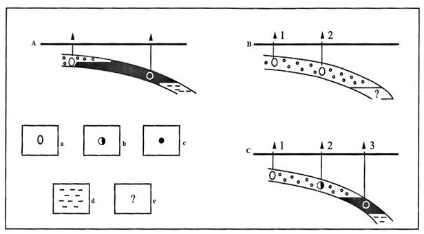
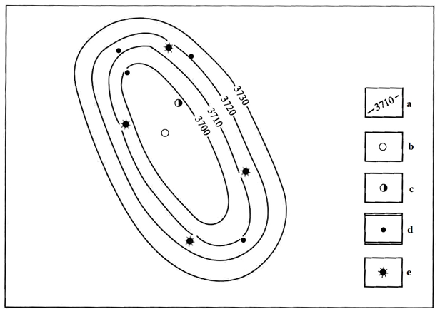
Figure 2: Deposit type. A: Oil and gas, B: Gas condensate, C: Oil and gas condensate. a: Condensate, b: ICS, c: Oil, d: Water, e: Undefined part of the section In the new structure, where exploration wells are usually laid in the vault part and along its long and short axes, the gas part of the deposit is usually uncovered. Wells located on the wings or periphery may also penetrate the gas part of the deposit (Figure 2B, wells 1 and 2). If the composition and properties of the obtained condensates are not taken into account, the exploration practically ends here, and the deposit is exploited as a gas-condensate deposit. If well 2 yields NGC, then further drilling of the structure in well 3 should yield oil (Figure 2B). Practical use of such an approach is advisable for relatively tectonically quiet structures [10, 11]. For example, in the Nebitlidge field, commercial oil and gas bearing capacity has been established in several horizons from IX to NK8. Gas inflows with condensate, NCS and oil were obtained in the NK8 horizon. The lithological features of the underlying rocks have been studied. In order to reduce exploration costs, a variant of production wells location for pilot development of the deposit is proposed (Figure 3).
The principle of phase state determination by physical and chemical properties of hydrocarbon fluids extends to many other oil-and-gas bearing basins, provinces and regions, including sediments from Pliocene to Devonian and depths up to 5-6 km. The only condition is that HC fluids occur in terrigenous, carbonate or terrigenous-carbonate sediments. Thus, in Mesozoic-Cenozoic sediments of the Eastern Precaucasus (Izberbash, Duzlak, Bragunskoye, Malgobek, Zamankul, etc. fields) oils have density of 0.833- 0.885, boil up to 300°C by 33-50%, NBS-0.799-0.827 and 54-67%, respectively. In the Jurassic and Triassic sediments of South Mangyshlak, hydrocarbon fluids with density of 0.828-0.887, boiling up to 300°C by 18-37% (Kendyrly, Zhetybai, North-Rakushechnoye) are referred to oil. In the Lower Carboniferous and Upper Devonian sediments of the Lower Volga region, the Klenovskoye, Korobkovskoye and Zhirnovskoye fields contain light and medium-density oil (0.821-0.863) boiling at 42-53% up to 300 °C. Medium and heavy oils (0.875-0.922) are common in the Bavlinskoye, Shugurovskoye and Romashkinskoye fields in Tatarstan. Medium and heavy oils (0.875-0.922) boiling at 18-34% are common in the Bavlinskoye, Shugurovskoye and Romashkinskoye fields in Tatarstan. The condition related to the lithology of the host sediments is associated with the content of aromatic compounds (benzene, toluene, xylenes) in the easy-boiling fractions of hydrocarbon fluids in amounts not exceeding 15-20% of the sum of other HC classes. The high content of aromatic HCs significantly increases the density of condensates and oil, because among hydrocarbons with the same content of carbon atoms, arenes have the highest specific gravity (Table 3).
| Number of C atoms in the molecule | Hydrocarbon | Density |
|---|---|---|
| 6 | n. Hexane | 0,6594 |
| methyl cyclopentane | 0,7486 | |
| Cyclohexane | 0,7786 | |
| Benzene | 0,8790 | |
| 7 | n.Heptane | 0,6837 |
| methyl cyclohexane | 0,7694 | |
| Toluene | 0,8670 |
Table 2: Specific density of aromatic hydrocarbons.
Discussion and conclusions
Hydrocarbon (HC) fluids containing more than 20 per cent aromatic hydrocarbons occur predominantly in Upper Jurassic sediments, which are often complicated by saline formations [12, 13]. These sediments are represented by chemogenic-terrigenous-carbonate rocks, which are characteristic of such regions as the Gulf of Mexico and the Persian Gulf, the Eastern Precaucasus, and the Amu Darya syneclise on the Turan plate. On the example of the fields of Plain Dagestan, such as Solonchakovskoye and Ravninnoye, it can be noted that gas condensates obtained from Jurassic deposits at depths from 3.4 to 5.1 km have densities ranging from 0.802 to 0.851 and contain up to 97% of fractions with boiling points up to 300°C, of which 30-60% are arene hydrocarbons.Similar condensates have also been identified in Turkmenistan and Uzbekistan fields such as South Kuruk, Davaly, Kirpichli, Malay, Bagadja, Kulbeshkak, Urtabulak and others [14]. When analysing the composition and properties of these fluids, it was found that for hydrocarbon fluids containing more than 20-30% of aromatic hydrocarbons in easy-boiling fractions, there are clear criteria for their classification. Liquids with density up to 0.830 are considered condensates, liquids with density from 0.830 to 0.850 are classified as ICS (intercondensate mixture), while oils have density over 0.850.
Thus, the developed method of determining the phase state of liquid hydrocarbon fluid has a wide application both in the interterritorial and interstratigraphic context. This method is based on the determination of arenes content in petrol fractions, density and fractional composition of the fluid. It is important to note that an additional criterion for determining the phase state of HC fluid is the ratio of gas and liquid phases, which allows more accurate classification of the obtained fluids and making informed decisions on their development and exploitation.
References
-
Sanjuan B, Gourcerol B, Millot R, Rettenmaier D, Jeandel E, et al. (2022) Lithium-rich geothermal brines in Europe: An up-date about geochemical characteristics and implications for potential Li resources. Geothermics 101: 102385.
-
Deryaev AR (2024) Engineering aspects and improvement of well drilling technologies at the Altyguyi field. Machinery & Energetics 15(2): 9-20.
-
Omidpour A, Rahimpour H, Moussavi HR, Mahboubi A (2023) Anhydrite fabrics as an indicator for relative sea- level signatures in the sequence stratigraphic framework of a carbonate ramp. Marine and Petroleum Geology 155: 106400.
-
Munk LA, Boutt DF, Moran BJ, McKnight SV, Jenckes J (2021) Hydrogeologic and geochemical distinctions in freshwater‐brine systems of an Andean salar. Geochemistry, Geophysics, Geosystems, 22(3): e2020GC009345.
-
Charton R, Kluge C, Blanco FD, Arnould DA, Bryers, et al. (2021) Syn-depositional Mesozoic siliciclastic pathways on the Moroccan Atlantic margin linked to evaporite mobilisation. Marine and Petroleum Geology 128: 105018.
-
Deryaev AR (2024) Features of the construction of directed deep wells in Turkmenistan. Italian Journal of Engineering geology and environment №1 Romn-Italy: 35-47.
-
Abdullaev GS, Bogdanov AN, Eidelnant NK (2020) Current state and prospects for the development of geological exploration for oil and gas in the surkhandarya region of the republic of Uzbekistan. Oil and gas geology. Theory and Practice 15(4): 40.
-
Ma Z, Mei G (2021) Deep learning for geological hazards analysis: Data, models, applications, and opportunities. Earth-Science Reviews 223: 103858.
-
Deryaev AR (2024) Main characteristics of the geological structure of the evaporite formation of the Amu Darya syneclise. Grassroots Journal of Natural Resources 7(2): 251-273.
-
Kassymkanova KK, Istekova S, Rysbekov K, Amralinova B, Kyrgizbayeva G, et al. (2023) Improving a geophysical method to determine the boundaries of ore-bearing rocks considering certain tectonic disturbances. Mining of Mineral Deposits 17(1): 17-27.
-
Huang S, Li J, Wang T, Jiang Q, Jiang H, et al. (2022) Application of light hydrocarbons in natural gas geochemistry of gas fields in China. Annual Review of Earth and Planetary Sciences 50: 13-53.
-
Chotpantarat S, Thamrongsrisakul J (2021) Natural and anthropogenic factors influencing hydrochemical characteristics and heavy metals in groundwater surrounding a gold mine, Thailand. Journal of Asian Earth Sciences 211: 104692.
-
Franco LM, Terra LEF, Panetto LP, Fontes SL (2024) Integrated application of geophysical methods in Earth dam monitoring. Bulletin of Engineering Geology and the Environment 83(2): 62.
-
Deryaev AR (2024) Drilling of direçtional wells in the fields of Western Turkmenistan. Scientific journals Grassroots Journal of Natural Resources 7(2): 347-369.
- Nigeria’s Vulnerability in the Face of Global Energy Policy
- A Simulation Study of Investigation of Optimum Oil Production Performance by Applying Various Gas Injection Methods in Oil Reservoir
- Characterization of Permo-Triassic Reservoirs through Thermal Maturity Assessment of Westphalian Source Rocks in the Cheshire Basin
- Influence of Microwax on the Rheological and Thermal Behaviour of a Wax Crude Oil
- Real-Time Monitoring and Performance Optimization of Steam Injection in Heavy Oil Reservoirs Using Fiber Optic Sensing and Integrated Predictive Simulation Models
- Rapid On-Site Determination of the Total Petroleum Hydrocarbon Content of Soils by Handheld Fourier Transform Near-Infrared Spectroscopy: Development of a Global, Site- and Scanner- Independent Calibration Model