Revision of Important Bird and Biodiversity Areas of Armenia
The Important Bird and Biodiversity Areas (IBAs) of Armenia have been recognized in 2000-2013, however, since that, changes took place in IUCN Red List and in IBAs’ criteria. The current paper is aimed at revision of 18 IBAs of Armenia, describing their bird diversity, current and potential threats, existing and proposed conservation measures. The revision reveals that: (1) 14 IBAs fit criteria of global importance and four IBAs fit criteria of regional significance; (2) 12% of the area of IBAs overlap with the public hunting lands; (3) 55% of all IBAs overlap with the working lands; (4) 45% of IBAs are covered by Nature Reserves, National Parkes, and State Sanctuaries; (5) 69% of IBAs are covered by candidate Emerald Sites; (6) IBAs are almost entirely covered by Key Biodiversity Areas. Also, the revision shows, that current network of IBAs doesn’t secure protection of number of trigger species. To improve IBAs network, it is necessary to expand the borders of some of the existing IBAs and to develop some new ones. For better protection of birds and their habitats, it is important to realize a complex strategy of integrated management of the IBAs, which is detailed in the article.
Introduction
The Important Bird and Biodiversity Area (IBA) concept was developed by BirdLife International [1] more than 30 years ago. Initially, IBAs were identified only for terrestrial and freshwater habitats, however in the past decade, the methodology of IBA recognition and the process have been adapted also for marine environment.
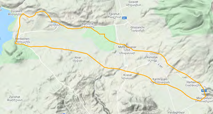
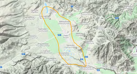
Armenia joined the process of identification of IBAs in 2000, and an initial list of five national IBAs appeared in the publication: “Important Bird Areas in Europe: priority sites for conservation” [1]. Later the list was expanded, making at current 18 IBAs in the country, which are presented in Table 1 and on Figure 1. However, the further development of the IBA network faced some issues. From one side, the existing information is insufficient for management of the areas. From another side, a number of changes took place in regards to uplisting and downlisting of the species in IUCN Red List [2], but that process did not reflect the Armenian IBAs. And eventually, from the third side, the BirdLife International has modified the criteria of recognizing the IBAs [3], and that process also has not reflected the current IBAs of Armenia. Taking the mentioned above into consideration, there is a need for revision of the IBAs of Armenia. The first step of that process, a re-inventory of the IBAs, was conducted in 2019 [4], and the current paper is the second step of revision, which is aimed at refreshing the criteria of the existing IBAs and information on the threats and conservation measures, as well as analyzing a coverage of the distribution range of trigger species by the IBAs’ network.
![Figure 1: However, the further development of the IBA network faced some issues. From one side, the existing information is insufficient for management of the areas. From another side, a number of changes took place in regards to uplisting and downlisting of the species in IUCN Red List [2], but that process did not reflect the Armenian IBAs. And eventually, from the third side, the BirdLife International has modified the criteria of recognizing the IBAs [3], and that process also has not reflected the current IBAs of Armenia. Taking the mentioned above into consideration, there is a need for revision of the IBAs of Armenia. The first step of that process, a re-inventory of the IBAs, was conducted in 2019 [4], and the current paper is the second step of revision, which is aimed at refreshing the criteria of the existing IBAs and information on the threats and conservation measures, as well as analyzing a coverage of the distribution range of trigger species by the IBAs’ network.](/fulltextimages/8273/fig_1.png)
| IBA Site name (alphabetical order) | IBA Criteria | Area (ha) | Code |
|---|---|---|---|
| 1. Amasia | A1, A4i, B1i, B1iv, B2 | 7,802 | AM006 |
| 2. Armash fish-farm | A1, A4i, B1i, B2 | 4,639 | AM004 |
| 3.Dsegh | A1, A2, B2 | 18,508 | AM008 |
| 4. Gndasar | B1iv, B2 | 2,345 | AM013 |
| 5. Gorayk | A1, B2 | 5,923 | AM016 |
| 6. Haghartsin | A1, A2, A3, B2 | 6,137 | AM009 |
| 7. Jermook | A1, B2, B3 | 9,467 | AM015 |
| 8. Khosrov Reserve | A1, A3, B2 | 113,100 | AM003 |
| 9. ake Arpi | A4i, B1i | 3,871 | AM001 |
| 10. Lake Sevan | A1, A4i, B1i | 154,627 | AM005 |
| 11. Meghri | A1, A2, A3, B2, B3 | 33,331 | AM018 |
| 12. Metsamor | A1, B1iv, B2 | 10,296 | AM012 |
| 13. Mount Ara | A1, A2, B2, B3 | 2,540 | AM010 |
| 14. Noravank | A1, B2 | 14,002 | AM014 |
| 15. Pombak mountains | A1, B2 | 56,675 | AM002 |
| 16. Sardarapat | A1, B1iv, B2 | 19,363 | AM011 |
| 17. Tashir | A1, B1iv, B2 | 17,948 | AM007 |
| 18. Zangezoor | A1, A2, A3, B2 | 23,236 | AM017 |
Table 1: List of Important Bird and Biodiversity Areas of Armenia [4].
Materials and Methods
According to general requirements for recognition of the IBAs, those should fit one or several criteria listed below [3]:
- Places of international significance for the conservation of birds and other biodiversity
- Recognized world-wide as practical tools for conservation
- Distinct areas amenable to practical conservation action
- Identified using robust, standardized criteria
- Sites that together form part of a wider integrated approach to the conservation and sustainable use of the natural environment Therefore, the data needed for the re-inventory of the IBAs and analysis of their state include data on bird fauna of Armenia, data on existing and potential threats to the birds and their habitats, spatial data on land use, spatial data on areas of national or international conservation concern.
Bird Data Collection
For the current revision of the IBAs we used the data, which was collected in the period of 2003-2019 in frames of the National Bird Monitoring Scheme, developed by BirdLinks Armenia NGO. It includes (1) unstandardized observations (so called opportunistic data) and (2) standardized counts (data, collected according to standard methodology).
1. Unstandardized observations (opportunistic data) are usually provided by birdwatchers and contain minimum data requirements: precise identification of species, observation date, geographic coordinates, name of nearest locality (human settlement, mountain, historical site, etc.), breeding code, name of observer and his contacts. It is desirable to mention whether all observations have been recorded or the list represents only a selection of species. Every comment is useful (time, observation duration, number of people in the group, etc.). Since it’s not always possible to record precise geographical coordinates on the spot, information may be provided according to the 10x10 km square code.
2. Standardized counts (counts conducted within a certain time period), are led both by specialists and birdwatchers, having proper skills. Counts are implemented during a fixed period of time of 1 or 2 hours, when an observer passes the route in slow motion. It is desirable to make such counts at the time of the day, when birds are most active (as a rule, early in the morning). The best season for bird count is the period between 10th of May and 10th of June, nevertheless, data, collected in March-April and July-August are used as well (for some species, e.g., Bearded Vulture or Eagle Owl, the best period of count of breeding pairs is January-February). With this method, there are more requirements to data: precise identification of species, number of observed or acoustically recorded individuals, observation date, geographical location: 10x10 km square code, coordinates of a beginning of the route, start and end times of the count, name of nearest locality (human settlement, mountain, historical site, etc.), breeding code, name and contacts of observer/s. Collected data are entered into standardized protocols and when the field work is over are inputted into the National Database owned by BirdLinks Armenia NGO.
Both types of data have been collected using a huge volunteer force - over 1,100 persons in total.
Geographical Data Collection
This includes the boundaries of the IBAs, candidate Emerald Sites, Ramsar Sites, Key Biodiversity Areas (hereinafter KBAs), and Specially Protected Natural Areas (hereinafter SPNAs).
The spatial data on IBAs was obtained from BirdLife International [5], the data on KBAs was provided by WWF Armenia, the data on candidate Emerald Sites, Ramsar Sites, and SPNAs, as well as on Public Hunting Lands was provided by the Ministry of Environment of RA.
Threat Data collection
For collection of the data on existing and possible threats we have checked the land ownership, types and scale of various human activities, and interviews of some target groups.
The data on land ownership was collected through the National Cadaster and Department of Protected Areas of the Ministry of Environment. The data on human activities was collected through the National Statistical Agency and by visiting the sites.
The data on direct threats was collected through the semi-structured interviews of the local farmers and hunters. Additional information on the direct threats was accumulated in this period through social media, specifically the Birding Association of Armenia group.
Data Processing
The first part of the data processing includes preparation of the site accounts for each of the IBAs, listing the general description of the site, description of characteristics of avifauna and the priority species of global and national concern, features of land use and current threats, as well as existing and necessary conservation measures.
The second part of the processing includes comparison of the areas of IBAs with the distribution range of the trigger species , analysis of the IBA areas' overlap with the public hunting lands, and the IBAs’ overlap with the areas on national and global conservation concern, namely: SPNAs, candidate Emerald Sites, Ramsar Sites, and by KBAs. This part of processing was implemented using ArcGIS 10.0 (Environmental Systems Research Institute, Inc.).
Results and Discussion
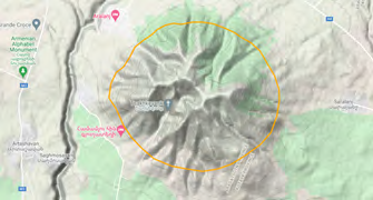
Amasia
The site is located at Shirak Plateau at the extreme northeast of the country at elevation range from 1973 to 2161 m above sea level (Figure 2). It was assessed as IBA in 2002 [6]. The area of Amasia IBA belongs to local communities and partly to Lake Arpi National Park. The IBA is represented by mountain steppes, meadows, and wetlands – swamps and marshes.
There are 216 species of birds recorded in the area, among which 102 are breeding within the IBA and 114 occur during migration or found in breeding season having this site as part of their foraging range [4]. The site is important for breeding populations of Common Crane Grus grus (B1b) and Corn Crake Crex crex (B1b), also it lays within the foraging range of breeding Black Stork Ciconia nigra (B1b). Also soaring migrants, like Steppe Eagle Aquila nipalensis (A1), Imperial Eagle Aquila heliaca (B1b), Lesser Spotted Eagle Clanga pomarina (B1b), and Demoiselle Crane Anthropoides virgo make congregations here, fitting the threshold of criteria B3c.
The area is used as pastureland, hey-making site, and arable lands and the habitat transformation and overgrazing strongly influence the area, causing drainage of the marshes and swamps. Also, some poaching rate was reported, putting such vulnerable species as Common Crane and Black Stork under special danger.
The area is partly included in Lake Arpi National Park. Also, it is partly covered by candidate Emerald Site “Lake Arpi National Park” (overlapping area makes 5,171 ha), is recognized as Ramsar Site and as KBA. The part of the IBA, which is included in the Lake Arpi National Park is being covered by the management plan of the SPNA, while the rest of the site is being managed as a community land.
The area involves just the beginning of the Akhuryan River Gorge, leaving the deep rocky canyon outside its borders. Meanwhile, the mentioned canyon holds the nesting sites of Black Stork, Golden Eagle Aquila chrysaetos, and Eagle Owl Bubo bubo, as well as the relict Aspen Grove, which in turn hosts the forest species. Therefore, it is important to extend the borders of the Amasia IBA in order to involve also the Akhuryan River canyon.
Among conservation measures it is important to officially designate the area as Emerald Site and to develop its management plan, which should strictly protect swamps and marshes, and should consider sustainable livestock farming and wildlife tourism. The tourism, via attracting of significant number of visitors in this area, can help to diversify the income of local communities and therefore to decrease the load on the terrestrial and aquatic ecosystems. Also, such activity will support a decrease of poaching in the region, creating a new conservation value for the bird species – targets for birdwatching.
Armash Fish-Farm
Armash fish-farm is located in Ararat Plain at elevations 781-794 m above sea level, and represents the largest carp-farm in Armenia, which consists of 29 earth ponds with a total cover of 1,514 ha (Figure 3). The site was last assessed in 2013 [7]. The area also includes large areas of saltwort semidesert and a wastewater treatment pool. The fish-ponds are divided between several private owners, the semidesert areas are mostly owned by surrounding communities, and the wastewater treatment pool is owned by a mining company. The farm is fed by two major sources of water: a canal that brings water from the Araks River and artesian wells. The vegetation cover differs in various areas: the wetlands are dominated by Fragmites, Typha, and Carex, the semidesert areas host Chenopodium, Lepidium, Salsola, Alhagi, and Zygophyllum. Some ponds here have not been used over a decade and were transferred into seasonal brackish wetlands.
In total, there are 234 species of birds recorded here, among those, 93 species are breeding and 141 species are migrating through the area or are wintering here [4]. Most of the ponds are frozen in winter and therefore the site has lower importance for wintering waterfowl, however its significance as a stopover point is hard to overestimate, as the migratory bird fauna here is rich and diverse. The species observed here include globally threatened White- headed Duck Oxyura leucocephala (A1), Marbled Teal Marmaronetta angustirhostris (A1), Common Pochard Aythya ferina (A1), Ferruginous Pochard Aythya nyroca (B1a), Northern Lapwing Vanellus vanellus (B1a), Black- tailed Godwit Limosa limosa (B1a), Turtle Dove Streptopelia turtur (A1), as well as threatened at National level White- tailed Lapwing Vanellus leucurus (B1b), Savii’s Warbler Locustella luscinioides (B1b), Greylag Goose Anser anser, Kentish Plover Charadrius alexandrinus, and others. The area becomes gradually colonized by the Spur-winged Lapwing Vanellus spinosus (B1b) and it is the only known breeding place in Armenia for White-headed Duck, White-tailed Lapwing, and Kentish Plover. The site is primarily important for hosting the congregations of a wide variety of waterbirds, including at least 20% of the population of Armenian Gull Larus armenicus, and thus fitting the criteria A4, as well as criteria B3a and B3b.
Armash area has a primary objective as a fish-farm. It potentially creates a conflict between the farm management purposes and conservation priorities, as from one side the fish-eating species are influencing the yield, and from another side, the intensive production of fish requires less mosaic structure of the ponds, and such requirement leads in decreasing of the shoreline vegetation and birds’ habitats.
Armash fish-farm is located at the heart of Armenian horticulture - Ararat Plain, which means that all the surrounding orchards and gardens are using (1) fertilizers, which can be washed by storm-water runoff to Armash causing eutrophication, and (2) pesticides, which find the same path to the wetlands, causing their pollution and poisoning.
Eventually, a significant part of the area is included in the public hunting lands. Although, by the efforts of several conservation organizations the replacement of the hunting by birdwatching was successfully negotiated with Armash fish-farm (one of the private owners), however, the surrounding fish-farms owned by other entrepreneurs, still serve as hunting zone. Beside direct persecution, which is influencing the threatened species of Ducks and Waders, the hunting here potentially causes lead pollution from bullets, which is a known threat for wetlands and waterbirds [8, 9].
Another major threat potentially comes from the gold mine’s wastewater treatment pool, which is located upstream to Armash, and can poison the area by heavy metals’ remains in the wastewater.
In 2016 Armash was designated as a candidate Emerald Site “Armash” (overlapping area makes 4,307 ha) but the further steps on its official recognition have not been undertaken.
The most important step in conservation of Armash IBA and protection of birds is its official recognition as an Emerald Site with further development of management plan for the area. The management plan should consider a combination of the interests of farms’ owners and conservation priorities. Such management plan should take into account a mitigation of the listed threats and development of a business model, where birdwatching can be integrated into fish production, compensating the losses of yield caused by fish-eating waterbirds and replacing the potential income from hunters.
Dsegh
The site is located at Gugark Mountain Range down to the gorge of Debet River taking an elevation range from 916 to 2849 m above sea level (Figure 4). It was last assessed as IBA in 2013 [10]. The area of IBA belongs to Gugark Forestry and the local communities. The IBA is covered by beech and oak dominated woodlands alternated by mountain steppes and deep rocky canyons.
There are 177 species of birds recorded in the area, among which 122 are breeding and 55 occur during migration or found in breeding season having this site as part of their foraging range. Dsegh area is important for breeding populations of Egyptian Vulture Neophron percnopterus (A1), Griffon Vulture (B1b), Peregrine Falcon Falco peregrinus (B1b), Black Woodpecker Dryocopus martius (B1b), Black Stork (B1b), and Semi-collared Flycatcher Ficedula semitorquata (B1b). Also, a number of migrants fly through the Debet River Canyon sometimes making congregations.
The area is used for various purposes, which include forest logging in frames of forestry duties, livestock husbandry, and processing of the arable lands under grains or vegetables at the areas cleaned from the forest. The current practices of forest management lead to forest fragmentation, the overgrazing causes degradation of the grasslands and prevention of natural forest regeneration. Occupation of the area under arable lands causes complete transformation of the habitats. Also, some level of poaching on large predators for trophies was reported from the area.
Dsegh IBA is covered by candidate Emerald Site “Debet Gorge” (overlapping area makes 18,390 ha) and is also recognized as the KBA, however the conservation efforts did not move further yet. The area is mentioned to be protected under Dilijan National Park [10], but the overlap makes only 17.5 ha.
Dsegh IBA doesn’t cover the majority of the Debet River Canyon, thus leaving outside most of the breeding colonies of Griffon Vulture and breeding pairs of Egyptian Vulture, Peregrine Falcon, and Eagle Owl. Therefore, it is necessary to extend the area of the IBA, in order to include those nesting sites.
Also, it is necessary to officially recognize the Emerald Site and to develop its management plan, which can consider the sustainable forest and grassland management as well as development of wildlife tourism in the area as a support in improvement of local livelihood, via diversification of the local businesses into guesthouse, catering, local guiding, horse riding, etc.
Gndasar
The site is located on the slopes of Vardenis Mountain Ridge in elevation range from 1894 to 2873 m above sea level (Figure 5). It was assessed as IBA in 2002 [11]. The area of IBA belongs to the community and about 40% of it is given to a private company as a long-term rent. The IBA is located at the southern slopes of the ridge, and its lower part is covered by shrublands, alternated by arid mountain steppe areas. With increase of elevation the landscape changes towards grassy mountain steppe, then to meadows, and then to sub-alpine carpets. The rigorous terrain of Gndasar IBA is rich with rocks, cliffs, and screes, and at the middle it is cut by several deep canyons. While in the lower part the scarce juniper woodlands are found, the numerous gorges are hosting remains of deciduous woodlands.
There are 123 species of birds recorded in the area, among which 84 are breeding and 39 occur during migration or found in breeding season having this site as part of their foraging range [4]. Gndasar area is important for breeding populations of high mountain species, such as Caspian Snowcock Tetraogallus caspius (B1b), Alpine Accentor Prunella collaris (B1b), Crimson-winged Finch Rhodopechys sanguineus (B1b), and White-winged Snowfinch Montifringilla nivalis (B1b). Soaring migrants, like storks, cranes, and raptors, sometimes make congregations here, occasionally reaching the threshold of criteria B3c.
Almost entire area is used as a pastureland for nomadic grazing by surrounding communities. Smaller portion is allocated for haymaking, which faces obstacles of the difficult terrain. Also, the area is included in the public hunting lands. At the lower elevation, Gndasar IBA’s natural grasslands suffer from the intensive pasture use, which causes overgrazing with all the subsequent issues of soil erosion, which is particularly dangerous at this steep area. Additional threats come from poaching, since the level of hunting control is substantially low.
The area is just slightly covered by Emerald Network (overlapping area makes 1%) and is recognized as KBA. The Gndasar IBA is mentioned to be protected under Lake Sevan National Park [10], but there is no overlap between these sites.
The site covers just a small portion of the subalpine area, leaving a significant portion of the high-mountain specialists outside. Therefore, it is recommended to slightly expand the borders of the IBA, to secure fuller involvement of the subpopulations of the subalpine birds.
For habitat and species protection, it is important to officially designate the area as the Emerald Site, then to develop its management plan, which can consider habitat friendly grazing schemes and support development of wildlife tourism in this area, thus providing the necessary support to the surrounding communities and provoke development of local hospitality services in accordance to the ecotourism standards. The incomes from wildlife tourism can be used for guarding the area, thus securing protection of endangered species of birds and mammals from poaching.
Gorayk
The site is located at the Sisian Plateau in elevation range from 2028 to 2871 m above sea level (Figure 6). It was assessed as IBA in 2006 [12]. The area of IBA belongs to local communities. The IBA is covered by grassy and tragacanth mountain steppes and meadows.
There are 203 species of birds recorded in the area, among which 83 are breeding and 120 occur during migration or found in breeding season having this site as part of their foraging range [4]. Gorayk area is particularly important for breeding populations of Lesser Kestrel Falco naumanni (B1b), Montagu’s Harrier Circus pygargus (B1b), Spotted Crake (B1b), and Egyptian Vulture (A1). Also soaring migrants, like Demoiselle Cranes, Black Storks, and a number of Raptors sometimes make congregations here, reaching a threshold of criteria B3c.
The terrestrial area is used mainly for livestock husbandry, which includes pasturelands and haymaking sites and for cereals fields. Intensive livestock husbandry causes overgrazing and uncontrolled mowing. The arable lands are regularly exposed to pesticides. The water reservoir is primarily used to feed the Hydro Power Plants and to irrigate the cultivated lands at the lower areas. The area is located next to the proposed gold mine, which potentially can cause pollution of the ecosystem by heavy metals.
The area is partly included in the Emerald network, being covered by the candidate Emerald Site “Gorhajk” (overlapping area makes 3,742 ha) and also is recognized as the KBA.
Initially the Gorayk IBA was designated for protection of the only known colony of Lesser Kestrel in Armenia [12], since the species was assessed as Vulnerable until 2011 [13]. Currently, there is one bigger colony of the species found in close proximity of the Gorayk IBA, so extension of its borders will allow inclusion of the second colony of Lesser Kestrel, as well as will cover the entire surface of the water reservoir and the Vorotan River Gorge, with the nesting areas of Egyptian Vulture.
Further conservation measures should include official designation of the area as an Emerald Site, with subsequent development of the area’s management plan. Within the management plan it is important to consider sustainable grazing and haymaking schemes, and is moreover important to mitigate the risks, related to potential soil and water pollution from the gold mine. For the purpose, it is necessary to secure a proper Environmental Impact Assessment of the mining project, and further monitoring of key indicators, including indicators of biodiversity.
Haghartsin
The site is located at Khalab and Ijevan mountain ridges at elevation range from 1199 to 2472 m above sea level (Figure 7). It was assessed as IBA in 2006 [14]. Part of the area of IBA belongs to Dilijan National Park, while another part – to local communities. The IBA is covered by deciduous forest dominated by beech and oak and is represented by subalpine humid steppes and meadows. Some rocky outcrops here form cliffs and screes.
There are 120 species of birds recorded in the area, among which 110 are breeding and 10 occur during migration or found in breeding season having this site as part of their foraging range [4]. Haghartsin area is important for breeding populations of Caucasian Grouse Lyrurus mlokosiewiczi (B1a), Bearded Vulture Gypaetus barbatus (B1a), Griffon Vulture (B1b), Caspian Snowcock Tetraogallus caspius (B1b), Semi-collared Flycatcher Ficedula semitorquata (B1b), and Black Woodpecker Dryocopus martius (B1b).
The forested part of the area is included in Dilijan National Park. Despite that the illegal logging sometimes takes place in the area, causing deforestation. Some urban development in this resort area also causes decrease of such sensitive species as Tawny Owl Strix aluco, Semi-collared and Red-breasted Ficedula parva Flycatchers, Black and Middle Spotted Leiopicus medius Woodpeckers. The grassland part of the IBA mostly belongs to the community and is used as pastureland, causing overgrazing and disturbance of ground- breeders by shepherds’ dogs.
Being in a great extent covered by Dilijan National Park, the area is managed under the National Park’s guidelines. Also, it is partly covered by two candidate Emerald Sites: “Dilijan National Park” (overlapping area makes 4,717 ha) and “Lastiver” (overlapping area makes 1,689 ha) and is recognized as KBA.
The IBA captures a small fragment of the old-growth forest, leaving significant portions of the forest interior, which belongs to Dilijan National Park, outside. It is, therefore, necessary to expand the area of the IBA in order to capture important breeding habitats of the forest specialists. Another necessary measure is related to official designation of the entire area, which includes forests and subalpine meadows as Emerald Site, and further development of an integrated management plan that will consider Dilijan National Park and the Emerald Site. The management plan can consider ecotourism for sustainable financing of conservation actions and development of rural communities. Such management plan should also take into account grazing schemes, with special stress on protection of the sites, important for breeding of threatened species, such as Caucasian Grouse and Corn Crake.
Jermook
The site is located along Arpa River’s watershed at elevation range from 1369 to 2685 m above sea level (Figure 8). It was assessed as IBA in 2006 [15]. The part of the IBA’s area belongs to local communities, while the rest belongs to Jermuk Hydrological, Jermuk Forest, and Herher Open Woodland State Sanctuaries. The habitats of the IBA are changing with increase of elevation from semidesert, passing through juniper woodlands, getting into deciduous oak dominated forest, and eventually being transferred into subalpine carpets. Along its way, the Arpa River flows in a canyon, formed by high cliffs, rocks and screes.
There are 170 species of birds recorded in the area, among which 125 are breeding and 45 occur during migration or found in breeding season having this site as part of their foraging range [4]. Jermook area is important for breeding populations of several birds of prey, such as Egyptian Vulture (A1), Bearded Vulture (B1a), Golden Eagle (B1b), Peregrine Falcon (B1b), and Eagle Owl Bubo bubo (B1b). Also, the area is one of the few sites in Armenia, which attracts Black- throated Thrush Turdus atrogularis in winter.
Significant portion of the area is used as a resort, and lands are being gradually urbanized with continuous development of tourism infrastructure. The rest of the lands are used for intensive livestock husbandry, causing overgrazing, and for grain cultivation, transforming the natural habitats into arable lands. There is a poultry farm in the area, which produces some waste that potentially can cause organic pollution of the Arpa River. Part of the area is included in the public hunting lands, which, under conditions of poor control, causes some poaching. Thus, illegal shooting and trapping of Raptors was documented in the area mainly aimed at selling the trophy or the nestlings as pets for local restaurants.
The area is partly included in Jermuk Hydrological, Jermuk Forest, and Herher Open Woodland State Sanctuaries, as well as is recognized as a candidate Emerald Site “Jermuk” (overlapping area makes 5,864 ha) and as a KBA, however the protection of the bird species and their habitats is not moved further.
In frames of the international programs, it is important to officially recognize the area as Emerald Site, and then develop its management plan, which should consider the careful impact assessment of all the new infrastructure projects as well as should set up strict protection of the nesting sites of Raptor species. Also, the plan can consider development of wildlife tourism in the area, which can create a new value for the bird species. Such development should be aligned with the education program aimed at local people.
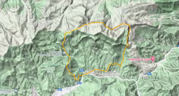
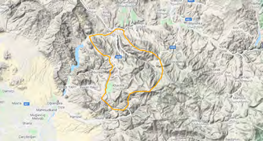
Khosrov Reserve
The site is located at the slopes of Gegham Mountain Ridge, occupies an elevation range from about 1102 to 2966 m above sea level (Figure 9), and includes a wide variety of landscapes within this range. During the first assessment in 2000, the site was including only Khosrov Forest State Reserve [1], however later, in 2013, the area was expanded to involve a significant portion of Gegham Ridge and the Vedi Hills [16]. About 25% of the area is covered by Khosrov Forest State Reserve owned by State, while the rest of the area (75%) is located on community land. The lower belt of the IBA is occupied by semideserts, which show great variation, hosting wormwood dominated, saltwort dominated, and scrubby semideserts. The belt is gradually changing into juniper woodland, an area dominated by Juniper trees. With the increase of altitude, it is replaced by the next belt, the deciduous forest, dominated by oak and horn-beam. Above timberline the wet meadows are located, which are quickly changed into subalpine carpets alternated with rocks and screes. The area is cut by two major canyons formed by Azat and Vedi Rivers and a number of smaller gorges. The area is rich with high cliffs, which provide breeding space for various raptors and other birds.
Khosrov Reserve hosts 191 species of birds, including 146 breeding and 45 migratory and wintering species [4]. The area is the only known spot in Armenia, where such species as Cinereous Vulture Aegypius monachus (B1a), Lanner Falcon Falco biarmicus (B1b), Trumpeter Finch Bucanetes githagineus (B1b), Mongolian Finch Bucanetes mongolicus (B1b) and Desert Finch Rhodospiza obsoleta (B1b) are breeding. Also, it hosts variety of other globally or nationally threatened birds, such as Egyptian Vulture (A1), Bearded Vulture (B1a), Short-toed Eagle Circaetus gallicus (B1b), Caspian Snowcock (B1b), and Boreal Owl Aegolius funereus (B1b).
The 25% of the area are managed by the State Reserve and are aimed at protection of species and their habitats, while the rest of the area is occupied for horticulture, pasture, and haymaking. Khosrov Forest State Reserve is well protected at current, but the rest of the land is poorly managed for nature conservation purposes, though it is included in the candidate Emerald Sites “Khosrov Forest State Reserve” (overlapping area makes 23,145) and “Vedi Hills” (overlapping area makes 27,557 ha). Poor management of semidesert areas result in uncontrolled water acquisition and overgrazing, which is especially critical for such sensitive habitat specialists like Trumpeter Finch, Mongolian Finch, Desert Finch, Finsch’s Wheatear Oenanthe finschii, and Grey-necked Bunting Emberiza buchanani. Also, part of the area is allocated for public hunting, which, under conditions of poor control, results in exceeding of the quotas and in poaching.
For protection of birds and their habitats it is important to designate the entire area as an Emerald Site, and develop an integrated management plan for the State Reserve and the Emerald Site. Such a management plan should consider development and introduction of sustainable practices of pasture management including haymaking areas, as well as application of a careful assessment procedure to all new orchard development projects. Also, the management plan should consider restriction of the public hunting lands within the IBA.
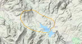
Lake Arpi
The site is located in the very north-west of Armenia and is represented by a water reservoir, which was constructed at the place of the small Lake Arpi. The site has an elevation range from 2010 to 2150 m above sea level (Figure 10). It was initially assessed as IBA in 2000 [1] and then reassessed in 2002 [17]. The area of the IBA belongs to the Lake Arpi National Park and the surrounding communities. The Lake is fed by streams, becoming the source of the Akhurian River. The terrestrial area is covered by mountain steppe and meadows with grassy vegetation. Significant portion of the area is covered by wetlands. While the water area in spring covers up 20 sq km and forms two islands (2 ha and 4 ha), in autumn, when the lake waters are used for irrigation, the shores of the two islands become merged.
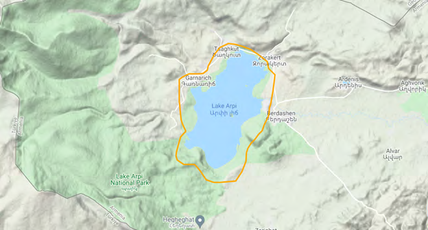
There are 223 species of birds recorded in the area, among which 105 are breeding and 118 occur during migration or found in breeding season having this site as part of their foraging range [4]. Lake Arpi area is important for breeding populations of Dalmatian Pelican Pelecanus crispus (B1a), Armenian Gull Larus armenicus (A4, B1b, B3a), and Common Black-headed Gull Larus ridibundus (B1b). Also, a number of migrants, like Teal Anas crecca, Northern Shoveler Anas querquedula, and Greater White-fronted Goose Anser albifrons regularly make congregations here, reaching the threshold B3b.
The Lake Arpi is used as a water reservoir for irrigation, which creates unstable water level, causing lack of developed shoreline vegetation, and eventually resulting in scarcity of breeding sites for the Ducks, Geese, Waders, Crakes, and others. Those species have to breed in the island, where they are being pressured by the Armenian Gull, aggressive nest predator. Also, the surrounding terrestrial arable lands cause pollution of the Lake, being processed by pesticides and fertilizers. In addition, since the public hunting lands lay in surroundings, the poaching cases also have been documented in the area and its close proximity.
The area is partly included in the Lake Arpi National Park, and into the network of candidate Emerald Site “Lake Arpi National Park” (overlapping area makes 3,868 ha), as well as is recognized as Ramsar Site and as KBA. In frames of those programs, it is important to officially recognize the area as the Emerald Site, and to develop an integrated management plan with the Lake Arpi National Park. Such management plan should consider creation of buffer wetlands at the shore side of the Lake Arpi, to secure the breeding habitats for Ducks, Geese, and shorebirds, far from the colony of Armenian Gulls, while the long-term management should aim at promoting creation of another water reservoir at the lower current of Akhuryan River, which can act as a buffer, keeping the water level of Lake Arpi stable, and thus supporting in development of shoreline vegetation. Also, the agri-food produced in this ecologically clean area should be positioned differently – as an organic product, thus increasing income of the local inhabitants, and minimizing the use of pesticides and inorganic fertilizers. The area has a significant potential for nature tourism, which can increase the income of National Park and thus, to support strengthening of control over poaching. Development of tourism will be beneficial also for local communities, which should indirectly become involved in the conservation.
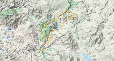
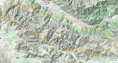
Lake Sevan
The site is located at the basin of the Lake Sevan located from 1875 to 2419 m above sea level (Figure 11). The last assessment of the IBA was implemented in 2013. The Lake is formed by three mountain ridges: Gegham, Areguni, and Vardenis and is fed by 28 rivers, while Hrazdan River flows out of the Lake Sevan. The shore of the Lake is mainly represented by sandy beaches, and although some water vegetation grows here, it is mostly depressed by urbanized landscape, as the area remains one of the major resorts of the country. The shoreline vegetation is represented by a variety of Fragmites, Typha, and Carex. Some bushes and trees have been planted at the area during Soviet time; they include sea-buckthorn bushes, pine and poplar trees. These areas became new habitat for the birds, hosting not only waterbirds, like Herons, but also woodland species, like Mountain Chiffchaff phylloscopus sindianus and Great Spotted Woodpecker Dendrocopos major. The other types of natural habitats are presented by meadows at majority of the terrestrial part of the site, also calcareous grasslands, and juniper woodlands on the North-east. Rocks and cliffs are patchy and are alternating the main landscape at the entire area.
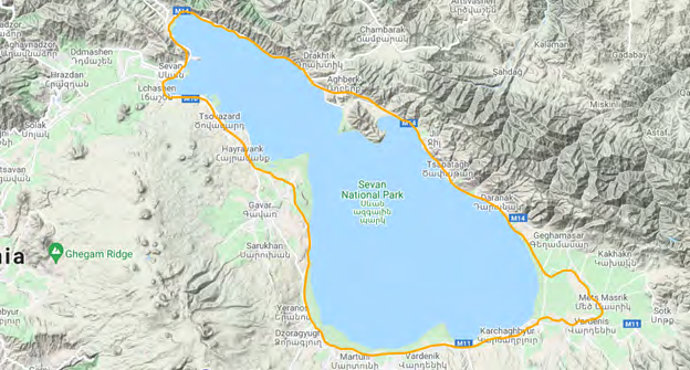
In total, there are 291 species of birds recorded here, among those, 112 species are breeding, and 179 species have been recorded on migration and during wintering [4]. Many of the species from that list have been recorded at the area only occasionally, however the others are regular migrants or winter visitors. The site plays an important role as a breeding habitat and as a stopover point for migratory and wintering birds. The key breeding species here are Turtle Dove Streptopelia turtur (A1), Saker Falcon Falco cherrug (A1), Common Pochard Aythya ferina (A1), Marbled Teal Marmaronetta angustirostris (A1), Ferruginous Pochard Aythya nyroca (B1a), Northern Lapwing Vanellus vanellus (B1a), and Armenian Gull Larus armenicus (A4, B1b, B3a). During migrations, the site hosts a wide variety of waterbirds, including Lesser White-fronted Goose Anser erythropus (A1), the number of migrants is reaching the threshold of criteria B3b.
The Lake Sevan’s problem started in the 1930s, when the government decided to begin decreasing the water level, in order to use the water for Hydro Power Plant and then for irrigation of agricultural lands in Ararat Plain. The process caused a decrease of the water level by 19 meters. Later, discovering the eutrophication, the government decided to stop that practice and to raise the water level. For the purpose the Arpa-Sevan tunnel was constructed, which was finished in the 2000s, and then the water level was increased on two meters. That increase caused the death of trees planted at the shoreline which caused another wave of eutrophication, and then it was decided to clear a part of the shoreline from trees. At current, the water of the Lake is planned to increase further, but it also continues to be used for irrigation needs, especially at the end of summer. It causes instability of the water level, which remains one of the major threats to the waterbirds and their habitats, as it prevents development of stable shoreline vegetation and coastal wetlands. Additional threats regularly emerge from surrounding horticulture fields, which are using fertilizers and pesticides. Those agents are being washed with the storm water to the Lake resulting to growth of phytoplankton and poisoning of the water. Also, some human disturbance and occasional poaching has been reported.
The area is partly covered by Lake Sevan National Park, and is designated as candidate Emerald Site “Sevan National Park” (overlapping area makes 154,507 ha), as Ramsar Site, and as KBA. The most important conservation measures should be directed to regulation of the water level, which can be implemented only via construction of a buffer water reservoir below the Lake Sevan in Hrazdan River Gorge. Such buffer reservoir would be able to supplement agricultural needs in dry seasons. The other conservation measures should be directed towards decrease of organic pollution of the Lake: by utilizing municipal waste to a compost and by construction of artificial wetlands on the rivers flowing into the Lake, so those wetlands will filter the water, thus decreasing the amount of pollutants. The other measures should include development of standardized norms for responsible tourism at the Lake, aimed at decrease of disturbance of birds at their breeding habitats.
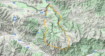
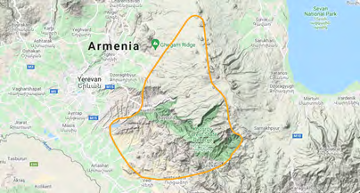
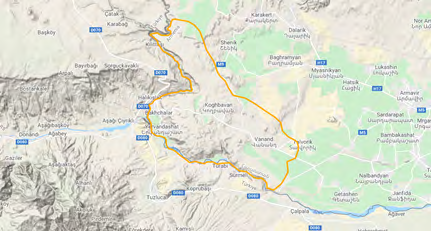
Meghri
The site is located at the eastern part of Meghri Mountain Ridge, in elevation range from 415 to 3159 m above sea level (Figure 12). It was assessed as IBA in 2006 [18]. The area of IBA partly belongs to National Park Arevik, Shikahogh State Reserve, Khustup State Sanctuary and also to local communities. The IBA’s habitats are very diverse, and include riparian scrubs, semideserts, juniper woodland, oak and horn-beam dominated forest, mountain steppe, and alpine carpets. The area is rich with rocky outcrops, which are forming high cliffs and screes.
There are 181 species of birds recorded in the area, among which 156 are breeding and 25 occur during migration and wintering [4, 19, 20]. Meghri area is important for breeding populations of Egyptian Vulture (A1), Bearded Vulture (B1a), Caucasian Grouse (B1a), Black Francolin Francolinus francolinus (B1b), Caspian Snowcock (B1b), Common Pheasant Phasianus colchicus (B1b), Short-toed Snake-eagle (B1b), Golden Eagle (B1b), Levant Sparrowhawk Accipiter brevipes (B1b), Peregrine Falcon (B1b), Boreal Owl (B1b), Persian Wheatear Oenanthe chrysopygia (B1b), Sombre Tit Poecile lugubris (B1b), Icterine Warbler Hippolais icterina (B1b), and See-see
Partridge Ammoperdix griseogularis (B1b).
The site is partly located at the protected area and partly at the community lands. At the southern end of the site the extensive horticulture is represented by fruit orchards, which are using pesticides, which in their turn can be poisonous for top predators, such as Raptors and Owls, as it already happened to Peregrine Falcons [21]. Also, the orchards in these areas continue expanding, and occupy the possible flat lands, which destroys the habitat for semidesert species, like Persian Wheatear [22] and See-see Partridge, and riparian scrubland species, like Black Francolin [23]. Some poaching here was reported, although as a rather rare occasion.
The area is included in SPNAs in a large extent, as well as into the network of candidate Emerald Sites “Zangezur” (overlapping area makes 7,652 ha) and “Arevik National Park” (overlapping area makes 18,018 ha) and is also recognized as KBA. The part of the IBA, which is covered by the SPNAs, is well preserved, while the rest of the area is exposed to the threats described above.
The Meghri IBA’s boundaries are leaving outside the significant part of breeding pairs of Egyptian Vulture, Bearded Vulture, Golden Eagle, Peregrine Falcon, Black Francolin, and especially the high-mountain specialists such as Wallcreeper Tichodroma muraria, although those species are declared as trigger ones [18].
For the full protection of the IBA, it is important to revise its boundaries and to extend those, covering the ranges of most of the priority species. Then it is necessary to officially recognize the Emerald Site, and then to develop the area’s integrated management plan, which should consider: (1) transformation of the local horticulture into organic one with minimizing use of pesticides; (2) careful assessment of new orchard projects, taking into consideration specifics of semidesert fauna; (3) development of the mosaic structure of orchards, leaving the space for riparian scrubland species, as Black Francolin, Common Pheasant, Menetrie’s Warbler Curruca mystacea, and others; (4) strengthening of the control over poaching in the SPNAs and their outskirts.
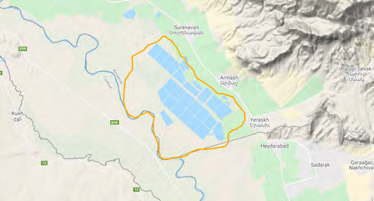
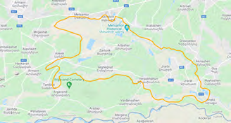
Metsamor
Metsamor area is located in Ararat Plain and is a combination of natural wetlands and semideserts and artificial orchards and arable lands at elevations 836-868 m above sea level (Figure 13). The area was assessed as an IBA in 2002 [24]. The ownership of the lands is partly private, such as arable lands of local communities, and partly is state, as the natural wetland areas along Araks river. The area is one of the centers of aquaculture, where a number of intensive trout and sturgeon farms are mixed with extensive carp-farming large ponds. Part of the public lands of the area is allocated for legal hunting. The semidesert areas are represented by specific plant composition, such as Chenopodium, Lepidium, Salsola, Alhagi, and Zygophyllum. The wetlands are naturally fed with the ground water and by outflowing waste water of the fish-farms. The dominating vegetation in the wetlands are species of Fragmites, Typha, and Carex. In orchards the most cultivated trees are apricot, peach, and walnut, also other fruit trees such as plumb, apple, and pear. Also, some parts of the area are occupied by vineyards. The most used decorative trees in the villages and along the roads are Poplar and in less extent the Willow. It creates a unique landscape for the villages, which represent some kind of riparian woodlands / shrublands [4].
The total number of bird species recorded in this area is 225, including 92 breeding species and 133 migratory and wintering ones [4]. The area hosts not only waterbirds, but also semidesert species, as well as the birds which are inhabiting riparian woodlands, and therefore find refuge in the villages. The area provides habitats for breeding populations of Common Pochard (A1), Turtle Dove (A1), Northern Lapwing (B1a), Levant Sparrowhawk (B1b), Black- winged Stilt Himantopus himantopus (B1b), and Savii’s Warbler (B1b), as well as for the migratory birds, like Black- tailed Godwit (B1a), Eurasian Curlew Numenius arquata (B1a), Pallid Harrier (B1a), and Greater Spotted Eagle Clanga clanga (A1). In regards of migratory waterbirds, the sites reaches the threshold of the criteria B3b and in regards of soaring migrants, Cranes and Raptors, reach the threshold of B3c.
Metsamor area is rather populated and traditionally was used for horticulture purposes, while quite recently the intensive production of trout and surgeon and extensive production of carp and other Cyprinids began occupying the area too. It leads to: (1) transformation of terrestrial habitats into orchards and gardens; (2) cleaning reed-bed in carp farms for intensification of the production; (3) pollution of the rivers and wetlands by effluents, which consist of persistent chemical disinfectants and antibiotics’ residuals from fish-farms, and pesticides and fertilizers from arable lands. Allocation of the area for public hunting creates other threats: (4) unintentional poaching on threatened species during hunting due to lack of hunters’ education and inspection control; (5) lead pollution of wetlands caused by bullets.
In 2016 Metsamor was designated as a candidate Emerald Site “Metsamor” (overlapping area makes 10,154 ha) and later in 2018 was included into KBAs, however the practical conservation here is still under development. The site is declared to be protected by Ararat Vordan Karmir Sanctuary [25], however there is no overlap of the boundaries of the IBA and the Sanctuary.
The important steps in protection of the area include official recognition of the Emerald Site, with further development of its management plan. Such a management plan should focus on designing of mutually beneficial models for various agricultural businesses, and in the same time considers control over effluents of fish-farms and arable lands, and strengthening of the control over hunters. Possible models of integration of birdwatching into carp-farms’ duties can potentially create the win-win situation. Another possible solution can come from development of sports’ fishing at the private ponds, which will increase the price of produced fish, and support in non-intensive fish-farming, but instead can develop a mosaic semi-natural structure of the fishing ponds. Also, promotion of the organic agriculture should be considered by the management plan.
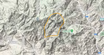
Mount Ara
Mount Ara is located in the central part of Armenia. It is isolated from most of the mountain ridges having some connectivity with Tsaghkounyats Ridge only (Figure 14). The elevation range of the area varies between 1874 to 2571 m above sea level. The area was primarily assessed in 2002 [25] for protection of the local population of Caucasian Grouse, and after that has not been re-evaluated. About 40% of the area belong to the forestry enterprise, while the remaining 60% belong to the surrounding communities. The Mountain represents a unique combination of habitats, where the northern slope is covered by deciduous forest and the southern slope is occupied by grasslands. The forest is dominated by oak and horn-beam trees, and the upper timberline is taken by birch trees. The grasslands change gradually from arid steppes at the bottom to wet meadows above the timberline. The central area of the mountain is cut by a deep canyon that provides wide breeding opportunities for cliff-nesters. Other residual cliffs and screes are spread on the slopes of the Mountain as well [4].
There are 137 species which occur in the area, including 99 breeding species and 38 migratory and wintering species. The area holds quite large populations of Caucasian Grouse (B1a) and Corncrake (B1b), as well as number of raptor species: both cliff nesters, such as Golden Eagle (B1b) and forest breeders, such as Lesser Spotted Eagle (B1b) and Booted Eagle Hieraaetus pennatus (B1b). The Black Stork and Egyptian Vulture breed in the vicinity of the IBA and regularly visit its foothills searching for prey. There is also quite intensive migration that goes around the Mountain through Kasakh River Gorge.
The woodland part of the area belongs to the forestry enterprise and is used for timber production. The rest of the area is occupied for livestock husbandry. The lower parts of the grassland are usually used for nomadic grazing, while the higher humid sites are mainly exploited for haymaking. Additionally, the site overlaps with public hunting lands and is used for seasonal sports hunting.
Initially, the resources of the site are quite poor: the forest is represented by medium-sized trees, which do not fit the timber production objectives. The same is related to nomadic grazing, which causes the change of plant species composition and even erosion at some spots. Another disturbance comes from shepherds’ dogs, which are a danger for ground-nesters, and of course from the hunting in the breeding areas of such rare species as Caucasian Grouse and Corn Crake.
Also, it is necessary to mention that the boundaries of the area [25] do not cover the breeding habitats of Egyptian Vulture and Black Stork, as well as the main migration corridor of the soaring birds: Storks, Cranes, and Raptors.
The area is already designated as a candidate Emerald Site “Arailer” (overlapping area makes 2,464 ha); however, its protection is still having to be developed. For efficient conservation of the IBA, it is important to expand its boundaries as described above, then officially recognize the Emerald Site, and then to develop its management plan, which would have to introduce the land-friendly livestock husbandry practices, and shift of the activities of forestry enterprises towards non-timber production along with complete closing of the area for hunting.
Noravank
Noravank IBA is located on the slopes of Vayk mountains from the Arpa river at about 935 m above sea level to about the watershed at 2674 m above sea level (Figure 15). The area was assessed as IBA in 2002 [26]. The landscape of the area varies from riparian shrubland, through semidesert and juniper woodland, to arid mountain steppes and mesophilic meadows. The area is alternated with two major canyons, with cliffs of up to 200 m high. The riparian shrublands are dominated with Populus, Rubus, and Fragmites; the semideserts are represented with Atraphaxis, Amygdalus, and Rhamnus pallassii; the juniper woodlands are dominated by Juniperus polycarpos, Pyrus, and Crataegus; the steppe areas are represented by herbs with significant representation of Legumes, as well as by Astracantha and Onobrychis cornuta; and eventually the meadows are represented by wide variety of herbs and grasses [4]
In total, there are 146 species of birds recorded here, among those, 100 species are breeding and 46 species are migrating through the area or stay here overwinter [4]. The site represents an important breeding area for Egyptian Vulture (A1), Bearded Vulture (B1a), Short-toed Snake Eagle (B1b), Levant Sparrowhawk (B1b), Golden Eagle (B1b), and Eagle Owl (B1b). The area is located at the community lands, part of which have been allocated to Arpa Protected Landscape – an inter-community conservation area. The rest of the area is used for horticulture and livestock husbandry. Intensive grazing, uncontrolled mowing, and non-coordinated habitat transformation under orchards are the major threats here. Also, some poaching was reported, both: on game birds out of official hunting season and on raptors taken as trophy. Another threat comes from human induced fires: the local people often burn Astracantha spp. and Onobrychis cornuta bushes, either for quick fire for cooking or just for fun. Such a habit can provoke large-scale fire in the area.
With assistance of WWF Armenia, some portion of the IBA, by agreement of Areni and Khachik communities, was allocated to Arpa Intercommunity Fund, forming Arpa Protected Landscape. In 2016 the area was designated as Emerald Site “Gnishik Protected Landscape” (overlapping area makes 14,002 ha) and during 2017-2018 was included into KBAs and involved into the Ecoregional Conservation Plan. The next step in conservation is official designation of the Emerald Site and development of an integrated management plan for the area, combining efforts of Arpa Protected Landscape and Emerald Site. The management plan should take into consideration the wide opportunities of historical, cultural and nature tourism of the area, including birdwatching and butterfly-watching, as well as interests of local rural communities. It means development and installation of habitat-friendly livestock farming practices, which can improve sustainability of pasture use, while not influencing the sensitive wildlife. Also, the management plan should consider community education for decreasing of further poaching and fire possibilities.
Pombak Mountain Chain
The site is located at the Pambak Mountain Ridge, which is one of the longest chains of northern Armenia, extending for 65 km from the north-west to south-east. At the southern side the IBA is bordered by the Marmarik River. The site occupies an elevation range from 1551 to 3008 m above sea level (Figure 16). It was assessed as IBA in 2002 [27]. The area of the IBA belongs to local communities, to Gugark forestry, and part of it is included in Margahovit Sanctuary, Hanqavan Hydrological Sanctuary, Caucasian Rose-Bay Sanctuary and Dilijan National Park. The IBA is mainly covered by mountain steppes and meadows; however, its northern slope is occupied by oak-hornbeam forests and the upper timberline is formed by birch woodlands [4].
There are 97 species of birds recorded in the area, among which 95 are breeding and 2 occur during migration [4]. Pombak mountains are important for breeding populations of Caucasian Grouse (B1a), Caspian Snowcock (B1b), Wallcreeper (B1b), White-winged Snowfinch (B1b), Golden Eagle (B1b), and Corn Crake (B1b). Also, there are Bearded Vulture and Black Stork, which use the area for foraging, however it is unknown yet, whether the species are nesting within the IBA.
The area is used mainly for nomadic grazing and heymaking. Also, there is an existing iron open-pit mine, and there are several open-pits planned. The nomadic grazing causes overgrazing and maintains a presence of shepherds’ dogs, which are particularly threatening ground-nesters, like Caucasian Grouse, Grey Partridge, and Corn Crake. In the forested areas some cases of illegal logging have been documented. About 7,861 ha of the land is allocated as public hunting lands. Within the hunting lands and outside of those, a poaching on birds, like Grey Partridge Perdix perdix and Black Grouse for meet and various Raptors for trophy, was also reported.
The area is partly covered by Margahovit Sanctuary, Caucasian Rose-Bay Sanctuary, Hanqavan Hydrological Sanctuary, and Dilijan National Park. The part of the site is covered by two candidate Emerald Sites – “Dilijan National Park” (overlapping area makes 7,429 ha) and “Rhododendron caucasicum Sanctuary” (overlapping area makes 17,208 ha), also the site is covered by KBA. Although, the area is declared to be protected by Lake Sevan National Park and Arzakan-Meghradzor Sanctuary [27], but there is no overlap between the boundaries of the IBA and the National Park or the Sanctuary. The part of the area, which overlaps with the Dilijan National Park is managed under rules of the National Park, the areas of Margahovit and Hanqavan Hydrological Sanctuaries do not have management plans, the forests of the northern slope are managed by Gugark forestry, and the rest of the area is managed as community lands.
To increase efficiency of the area’s protection, it is important to officially recognize the Emerald Sites, and then develop the area’s integrated management plan that will unite the conservation priorities of the Emerald Site, IBA, National Park and the Sanctuaries. The management plan should consider sustainable grazing schemes, careful assessment of all the new mining projects and close monitoring of the existing ones. The area has significant potential for nature tourism, which should be explored in order to create financial sustainability of potential caretakers, who can cooperate with the local communities helping them in small business development. That kind of network can create a new attitude towards birds and other wildlife, and can help to better control illegal actions, such as poaching and tree cutting.
Sardarapat
The site is located in relatively flat semidesert area in elevation range from 916 to 1312 m above sea level (Figure 17). It was assessed as IBA in 2006 [28]. The area of IBA belongs to local communities. Significant portion of the IBA is represented by semidesert, dominated by wormwood, kochia, and other multi-year herbs, or low scrubs. The rest is made of arable lands for growing of livestock fodder, melons, and other fruits and vegetables. The IBA is located next to Akhuryan River gorge, which borders with Turkey and, being a deep rocky canyon hosts a number of cliff-nesters.
There are 154 species of birds recorded in the area, among which 77 are breeding and 77 occur during migration or found in breeding season having this site as part of their foraging range [4]. The Sardarapat area is important for breeding populations of Egyptian Vulture (A1), Black-bellied Sandgrouse Pterocles orientalis (B1b), Griffon Vulture (B1b), Golden Eagle (B1b) and Peregrine Falcon (B1b). Also, the site is an important corridor for soaring migrants, like Raptors, Cranes, and Storks, fitting a threshold of criteria B3c.
The area is being widely transformed into arable land, using all the possible water resources for irrigation. The pesticides applied over the horticultural areas pollute the areas. From another side, the area is included in the public hunting lands and under poor inspection control, poaching often takes place here. It is related to out-of-season shooting of game birds, shooting of the Sandgrouse and Bustard, and also shooting of Raptors during migration, especially the Honey Buzzard, which is being consumed as food in this area.
The area is designated as a candidate Emerald Site “Vanand” (overlapping area makes 18,228 ha) and as KBA. To secure conservation of the species it is important to officially recognize the area as Emerald Site and to develop its management plan. Such a plan should consider improvement of sustainable livelihood, which should take into account several aspects. First is the alternative, water-saving irrigation systems. The second, is the existing ecologically clean dry fruit production in Yervandashat village, which can be a driving force in development of pesticide free agriculture in the region. At third, the area has a significant potential for development of birdwatching and therefore, the work with tour operators on inclusion of the area in tour packages can support in attraction of the tourists to this neglected area. By
that time, the area has to be excluded from the public hunting lands. These activities, supplied by environmental education and public awareness campaigns, can help to decrease the poaching.
Tashir
Tashir IBA is located at Lori Plateau and is represented by a combination of grasslands, arable lands, and wetlands, alternated with forest and small tree plantation patches and at its southern part is cut with a canyon of Dzoraget River (Figure 18). The site was last assessed as IBA in 2013 [29]. Entire area is divided between communities except of the lakes and the Metsavan water reservoir, which are the property of the state. Most of the area is represented by various grasslands and arable lands; also, it includes a large water reservoir, number of small lakes, and quite big areas of grassy marshes. The vegetation cover differs in wetlands, which are dominated by Fragmites, Typha, and Carex, and grasslands, which are represented by various Gramineae, as well as Legumes, and other groups. Small patches of deciduous forests are mainly remaining of larger forested areas, while some pine plantations provide additional woodland sites. The area is a large agricultural site, where the grasslands are mainly used as pastures or haymaking sites, and the arable lands are aimed at growth of grains and some vegetables, such as cabbage and potato.
In total, there are 250 species of birds recorded in this area, among those, 114 species are breeding and 136 species are migrating through the area or wintering here [4]. Most of the wetlands are frozen in winter and thus the site plays a less important role for wintering waterfowl. However, the flat geography and large open water surfaces and wetland areas, combined with the grasslands and scrubs become important stopover area for various migratory birds, including Waterbirds, Passerines, Raptors, Cranes, and others. The area is therefore important for breeding populations of Common Pochard (A1), Turtle Dove (A1), Northern Lapwing (B1a), Red-necked Grebe Podiceps grisegena (B1b), possibly Common Crane (B1b) and for migratory Steppe Eagle (A1), Greater Spotted Eagle (A1), Imperial Eagle (A1), Black-tailed Godwit (B1a), and others. Hosting a number of Common Cranes, Demoiselle Cranes, and a variety of Raptors and waterbirds, the area reaches the thresholds of the criteria B3b and B3c.
Flat areas of Lori Plateau were traditionally used for the large-scale horticulture: growing of grains, cabbage and potato, while the slopes are mainly used for livestock husbandry. Therefore, for the terrestrial habitats the land transformation and overgrazing remain the main issues, while for the wetland areas it is also the pollution by fertilizers and pesticides. Surprisingly, quite a big portion of Metsavan reservoir is not included in IBA, as well as a big portion of Dzoraget River Gorge, which holds nesting sites of Egyptian Vulture. Since there are public hunting lands in the surroundings of the IBA, under poor control, the hunting (which in this case becomes poaching) takes place also inside the IBA.
Some portion of the IBA is covered by a candidate Emerald Site “Lori Lakes” (overlapping area makes 17,867 ha), however the conservation doesn’t move forward.
To improve the species and habitat protection, it is necessary to review the borders of the IBA and to include the Metsavan Reservoir completely and Dzoraget River Gorge in its majority. Subsequently, it is important to review the borders of the candidate Emerald Site, with its further official recognition, and development of a management plan. The latest should take into consideration the land use and sustainable grazing issues, as well as strict protection of the nesting sites of such vulnerable species as Common Crane.
Zangezoor
Zangezoor area is located at the eastern macro-slope of Zangezur Ridge and southern slopes of Bargushat Ridge. The elevation of the area ranges from 1741 to 3772 meters above sea level (Figure 19). The site was evaluated as IBA in 2002 [30]. Majority of the area is state owned as part of Zangezur Biosphere Complex, and only about 20% of the land belong to the surrounding communities. The area contains of two major types of habitats: deciduous forest and grasslands, which also can be conditionally divided into mountain steppes, meadows, and subalpine carpets. The forest is mainly dominated by oak and horn-beam, while also hosts other trees, such as willow and mountain ash. The mountain steppes are dominated by grasses and Astracantha species. The meadows are located in mosaic pattern and are represented by mesophilic type of vegetation again represented by Gramineae. The subalpine carpets include a restricted number of high-mountain plants, including mainly some grasses and legumes.
In total, there are 160 species of birds recorded here, among those, 129 species are breeding and 31 species are migrating through the area or wintering here [4]. Thus, this high-mountain area plays a more important role as a breeding site, rather than a stopover point for migratory birds. The species, which inhabit Zangezoor IBA include Caucasian Grouse (B1a), Caspian Snowcock (B1b), Golden Eagle (B1b), Booted Eagle (B1b), Peregrine Falcon (B1b), Wallcreeper (B1b), and White-winged Snowfinch (B1b). The area is used as a foraging range by Egyptian Vulture (A1) and Bearded Vulture (B1a), but those species breed outside the boundaries of the IBA, despite the statement in the description of the site [30].
Over 60% of the IBA is recognized as protected with a restricted access for livestock grazing. Partly it is conditioned by the fact that the area is used for drinking water acquisition, and therefore it is necessary to restrict an entry of the livestock at such an area. From another side, the area is located at the border zone with Nakhichevan, and thus is protected by military guards. Nevertheless, about 40% of the IBA is still managed by the local communities and is used for nomadic grazing, haymaking, bee-hiving, and small-scale gardening. Also, there are several small Hydro Power Plants on the mountain rivers of the area. Therefore, the major threats can be listed as follows: (1) the main one comes from nomadic grazing as intensive livestock husbandry might cause overgrazing with all the subsequent issues; (2) another big threat comes from the small Hydro Power Plants, as they withdraw quite a large portion of the water in the dry season, thus causing an influence on the local humidity and impacting the local climate; (3) eventually the poaching on the Red Listed Snowcocks and Grouses, as well as large Raptors has been also reported in the area.
Majority of the site is already included in Zangezur State Sanctuary, Arevik National Park, and Boghakar State Sanctuary. Also, it is covered by two candidate Emerald Sites “Zangezur” (overlapping area makes 11,661 ha) and “Arevik National Park” (overlapping area makes 2,867 ha), as well as by KBAs network. Taking those advantages into account, to protect the IBA, it is important to officially designate the Emerald Sites and to develop an integrated management plan, which will consider the objectives of IBA, Emerald Sites, SPNAs, and the KBA and will take into account the following points: (1) development and adaptation of habitat friendly grazing schemes; (2) will reconsider the Hydro Power Plants, and the water withdrawal amount; (3) will focus on development of nature tourism in this area and consider broad scale public advocacy of the surrounding communities.
Criteria of Existing IBAs
Review of the IBAs’ criteria is summarized in the Table 2.
| IBA Site name (alphabetical order) | IBA Criteria (new) | Area (ha) | Code |
|---|---|---|---|
| 1.Amasia | A1, B1b, B3c | 7,802 | AM006 |
| 2.Armash fish-farm | A1, A4, B1a, B1b, B3a, B3b | 4,639 | AM004 |
| 3. Dsegh | A1, B1b | 18,508 | AM008 |
| 4. Gndasar | B1b, B3c | 2,345 | AM013 |
| 5. Gorayk | A1, B1b, B3c | 5,923 | AM016 |
| 6. Haghartsin | B1a, B1b | 6,137 | AM009 |
| 7. Jermook | A1, B1a, B1b | 9,467 | AM015 |
| 8. Khosrov Reserve | A1, B1a, B1b | 113,100 | AM003 |
| 9. Lake Arpi | A4, B1a, B1b, B3a, B3b | 3,871 | AM001 |
| 10. Lake Sevan | A1, A4, B1a, B1b, B3a, B3b | 154,627 | AM005 |
| 11. Meghri | A1, B1a, B1b | 33,331 | AM018 |
| 12. Metsamor | A1, B1a, B1b, B3b, B3c | 10,296 | AM012 |
| 13. Mount Ara | B1a, B1b | 2,540 | AM010 |
| 14. Noravank | A1, B1a, B1b | 14,002 | AM014 |
| 15. Pombak mountains | B1a, B1b | 56,675 | AM002 |
| 16. Sardarapat | A1, B1b, B3c | 19,363 | AM011 |
| 17. ashir | A1, B1a, B1b, B3b, B3c | 17,948 | AM007 |
| 18. Zangezoor | A1, B1a, B1b | 23,236 | AM017 |
Table 2: Revised criteria of the IBAs.
The updated criteria demonstrate that out of 18 IBAs, 14 have global importance and four have regional significance.
Coverage of Trigger Species by IBAs
The current network of the IBAs was developed in 2000 to 2013, and thus, it is natural that in that time the network didn’t fully take into account several important species, such as globally threatened Egyptian and Bearded Vultures, Saker Falcon, Common Pochard, Turtle Dove, and Northern Lapwing, as well as regionally threatened Persian Wheatear, Yellow-billed Chough, Booted Eagle, Griffon Vulture, Black Francolin, and number of others. However, currently the distribution and abundance of those species is well studied [31, 32, 33, 34, 35, 36, 37, 38, 39, 40, 41, 42, 43, 44], making a solid foundation for the revision of IBAs. Majority of populations of the mentioned species lie outside the current boundaries of the IBAs. In many cases it happened because the boundaries didn’t take into consideration the existing nesting sites of those species, although the breeding areas were quite near, like it is visible in the cases of Amasia, Dsegh, Gorayk, Meghri, Mount Ara, and Tashir IBAs and the cliff-nesting species, like Egyptian Vulture, Bearded Vulture, Golden Eagle, Peregrine Falcon, Black Stork, and Eagle Owl. In other cases, the areas just have not been evaluated as IBAs. Thus, the middle and lower parts of Vorotan River Gorge hold high density of Egyptian Vultures, a pair of Bearded Vulture, and a number of other threatened species, and despite that, it remained out of the focus. Another example is Aragats Mountain, which hosts Egyptian Vulture, Bearded Vulture, Saker Falcon and a range of other species and again wasn’t evaluated. The next case is related to the Urts Mountains, which again hosts Egyptian Vultures, Bearded Vulture, a second population of Persian Wheatear in Armenia, and despite that wasn’t assessed as IBA. The next bunch of cases can be related to the areas, which combine forests with subalpine belts, such as Tsaghkunyats and Ijevan Mountain Ridges. Those areas secure habitats of Caucasian Grouse and a range of other threatened species, but have not been considered for evaluation under IBA criteria. And eventually, the beech and oak dominated forests, located within the watersheds of Agstev, Tavush, and Khndzorut Rivers, which are home to a number of forest specialists, such as Semi- collared and Red-breasted Flycatcher, Tawny Owl, Black, Medium-spotted and Little-spotted Woodpeckers, and cliff- nesters, like Egyptian and Griffon Vultures, Peregrine Falcon, and Yellow-billed Chough Pyrrhocorax graculus, again left out of the focus. The situation with waterbirds is somewhat better, although the fact that the Akhuryan Reservoir was not evaluated, despite the fact that it holds breeding populations of Common Pochard and a huge number of waterbirds during migration, remains unjustified.
Concluding the described above, there is an obvious necessity to modify the IBA network in Armenia for better coverage of the distribution range of the number of trigger species.
Conservation in IBAs
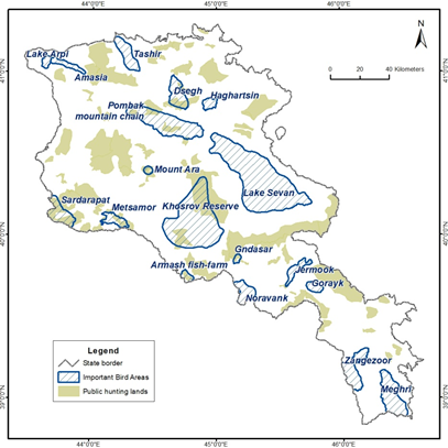
The IBAs are planned to be included in the legislation of Armenia, specifically in the Law on Fauna [45]. Currently, the IBAs overlap with the working lands, specifically the forestry, arable lands, pasturelands, and public hunting areas (Table 3). In total 14% of the area of IBAs (9 out of 18) overlap with the public hunting lands (Figure 20) and 57% of all IBAs overlap with the working lands. It creates a conflict of interests between four types of stakeholders: rural community, conservation related community, forestry enterprises, and hunters’ community.
| IBA Site name (alphabetical order) | Area (ha) | Hunting Lands | Protected Areas | Candidate Emerald Sites | KBAs | Working lands | |||||
|---|---|---|---|---|---|---|---|---|---|---|---|
| ha | % | ha | % | ha | % | ha | % | ha | % | ||
| 1.Amasia | 7,802 | 0 | 0% | 682 | 9% | 5,171 | 66% | 5,988 | 77% | 7,120 | 91% |
| 2. Armash fish- farm | 4,639 | 2,019 | 44% | 0 | 0% | 4,307 | 93% | 4,574 | 99% | 4,639 | 100% |
| 3. Dsegh | 18,508 | 6,334 | 34% | 17 | 0% | 18,390 | 99% | 15,312 | 83% | 18,491 | 100% |
| 4. Gndasar | 2,345 | 1,352 | 58% | 0 | 0% | 14 | 1% | 2,341 | 100% | 2,345 | 100% |
| 5. Gorayk | 5,923 | 0 | 0% | 0 | 0% | 3,742 | 63% | 0 | 0% | 5,923 | 100% |
| 6. Haghartsin | 6,137 | 0 | 0% | 3,632 | 59% | 4,717 | 77% | 6,132 | 100% | 2,505 | 41% |
| 7. Jermook | 9,467 | 256 | 3% | 4,541 | 48% | 5,864 | 62% | 9,418 | 99% | 4,926 | 52% |
| 8. Khosrov Reserve | 113,100 | 33,044 | 29% | 23,145 | 20% | 50,702 | 45% | 59,183 | 52% | 89,955 | 80% |
| 9. Lake Arpi | 3,871 | 0 | 0% | 2,959 | 76% | 3,868 | 100% | 3,629 | 94% | 912 | 24% |
| 10. Lake Sevan | 154,627 | 0 | 0% | 141,829 | 92% | 154,507 | 100% | 147,936 | 96% | 12,798 | 8% |
| 11. Meghri | 33,331 | 0 | 0% | 14,457 | 43% | 25,670 | 77% | 33,250 | 100% | 18,874 | 57% |
| 12. Metsamor | 10,296 | 4,222 | 41% | 41 | 0% | 10,154 | 99% | 9,974 | 97% | 10,255 | 100% |
| 13. Mount Ara | 2,540 | 1,917 | 75% | 0 | 0% | 2,464 | 97% | 2,529 | 100% | 2,540 | 100% |
| 14. Noravank | 14,002 | 0 | 0% | 2,849 | 20% | 12,878 | 92% | 12,832 | 92% | 11,153 | 80% |
| 15. Pombak mountains | 56,675 | 8,935 | 16% | 7,429 | 13% | 24,637 | 43% | 49,590 | 87% | 49,246 | 87% |
| 16. Sardarapat | 19,363 | 13,102 | 68% | 0 | 0% | 18,228 | 94% | 18,828 | 97% | 19,363 | 100% |
| 17. Tashir | 17,948 | 0 | 0% | 0 | 0% | 17,867 | 100% | 6,748 | 38% | 17,948 | 100% |
| 18. Zangezoor | 23,236 | 0 | 0% | 14,398 | 62% | 14,528 | 63% | 23,048 | 99% | 8,838 | 38% |
| Totals | 503,810 | 71,181 | 14% | 215,979 | 43% | 377,708 | 75% | 411,312 | 82% | 287,831 | 57% |
Table 3: Exploited and Protected areas within the IBAs. The figures show areas of overlap between IBAs and other types of lands,
There are different approaches of combining conservation with exploitation of the working lands. In forestry enterprises it is important to:
- Reduce forests’ fragmentation via tree planting programs.
- Replace use of pesticides for forest pest control by increasing the natural resilience of the forests.
- Reduce the logging of the trees at all. So called sanitary cutting or anti-fire logging should be replaced by strategies of increase of forest interior and forests’ humidity.
- In the areas, where some industrial logging is still allowed, it is necessary to develop a natural disturbance emulation logging policy with obligatory identification of biodiversity important trees and areas, which should not be disturbed.
- Such restrictions should be compensated via development and marketing of non-timber forest production and eco-tourism in the surrounding rural communities.
In the arable lands it is important to:
- At the grain and vegetable fields, to consider development of the natural habitats at the edges of the fields.
- At the orchards, wherever possible, to consider development of a mosaic structure of the orchards and the indigenous habitats.
- Reduce use of pesticides, replacing that with the biological methods of pest control.
- Apply careful impact assessment procedure to every new project aimed at development of new orchards, vineyards, or other arable lands. On the pasturelands to:
- Consider development of sustainable grazing, which can by based on careful planning of the number of livestock, rotational grazing schemes, weed suppression, and sawing legume plants.
- Wherever possible to consider livestock housing instead of outrun type of livestock husbandry.
All the programs of IBAs’ development should be supported by the continuous monitoring of birds as bioindicators of undertaken measures and efficiency of IBAs’ management. The IBAs are often partly covered by SPNAs, candidate Emerald Sites, Ramsar Sites, and by KBAs. In total 43% of IBAs (11 out of 18) are covered by Nature Reserves, National Parkes, and State Sanctuaries (Figure 21). In other IBAs the SPNAs cannot be created, because the lands belong to the community, and the Law on SPNAs of RA [46] doesn’t have a point of Community Protected Areas.
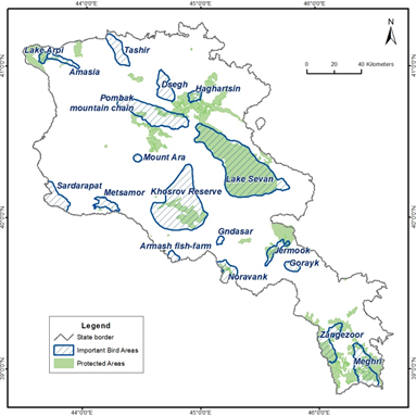
In total, 75% of IBAs are covered by candidate Emerald Sites as shown on Figure 22 [47]. And eventually, 82% of the IBAs are covered by KBAs [48] as shown on Figure 23. Nevertheless, the IBAs don’t benefit from these advantages .
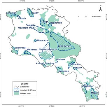
To support conservation in IBAs we suggest to enforce the mechanism of the Emerald Network, as they cover a significant portion of the IBAs, and because the obligations of the Republic of Armenia to the Berne Convention include development of the management plans of such areas (Figure
23). Thus, the first step for all the IBAs of Armenia is official recognition of candidate Emerald Sites by Berne Convention. The second step is a development of management plans for the Emerald Sites, which in many cases can integrate or be integrated in the management plans of SPNAs and also consider priorities of KBAs. The management plans should take into consideration the principles of conservation in working lands described above. In most of the cases, the public hunting lands should be extracted from the boundaries of IBAs.
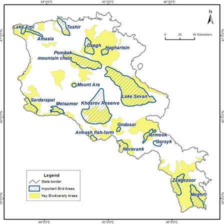
Acknowledgements
The authors are grateful to the Science & Information Management team at BirdLife International for providing the IBA spatial data, WWF Armenia for providing spatial data on KBAs and for help in GIS analyses, Ministry of Environment of RA for providing data on SPNAs, Emerald Network, and Public Hunting Lands, and National Statistical Agency for data on human activities. During 2010–2021 the data collection in wetland areas was supported by Whitley Fund for Nature in frames of series of grants on Sustainable Wetland Management in South Caucasus, and during 2015– 2017 the surveys in Armenia were also supported by the European Bird Census Council through a grant from the MAVA Foundation for the European Breeding Bird Atlas (EBBA2). The authors are especially grateful to all the volunteers who contributed in the data collection. The Deutsche Gesellschaft für Internationale Zusammenarbeit (GIZ) GmbH supported Environmental Programme and Innovation Challenge competition “GreenOvation" contributed to the data analysis. The analysis of the influence of public hunting lands was supported by the Eurasia Partnership Foundation, Embassy of Sweden in Yerevan and SIDA through the Civil Society Support for Ensuring Impact on Reforms project. Also, the authors are grateful to Sofía Capellán for guidance on the application of the IBA criteria.
References
-
Heath MF, Evans MI, Hoccom DG, Payne AJ, Peet NB, et al. (2000) Important Bird Areas in Europe: priority sites for conservation, UK: BirdLife International 1(2).
-
BirdLife International (2017) The IUCN Red List of Threatened Species 2017.
-
BirdLife International (2020) Guidelines for the application of the IBA criteria.
-
Aghababyan K (2019) Important Bird and Biodiversity Areas of Armenia. Technical Report. Ministry of Environment of the Republic of Armenia. Yerevan pp: 52.
-
BirdLife International (2022). The World Birds and Biodiversity Database. Developed by BirdLife International. Available at http://datazone.birdlife.org/ site/mapsearch [Accessed on 20/01/2022).
-
BirdLife International (2022b) Important Bird Areas factsheet: Amasia.
-
BirdLife International (2022c) Important Bird Areas factsheet: Armash fish-farm.
-
Beintema N (2001) Lead Poisoning in Waterbirds. International Update Report 2000. Wageningen, The Netherlands: Wetlands International.
-
Mateo, R. and Kanstrup N (2019) Regulations on lead ammunition adopted in Europe and evidence of compliance. Ambio 48: 989-998.
-
BirdLife International (2022d) Important Bird Areas factsheet: Dsegh.
-
BirdLife International (2022e) Important Bird Areas factsheet: Gndasar.
-
BirdLife International (2022f) Important Bird Areas factsheet: Gorayk.
-
BirdLife International (2021) _Falco naumanni_. The IUCN Red List of Threatened Species 2021.
-
BirdLife International (2022g) Important Bird Areas factsheet: Haghartsin.
-
BirdLife International (2022h) Important Bird Areas factsheet: Jermook.
-
BirdLife International (2022i) Important Bird Areas factsheet: Khosrov Reserve.
-
BirdLife International (2022j) Important Bird Areas factsheet: Lake Arpi.
-
BirdLife International (2022l) Important Bird Areas factsheet: Meghri.
-
Aghatelyan H (2020) Finding of the Boreal Owl _Aegolius_ _funereus_ in the Shikahogh Reserve of Armenia. Russian Ornithological Journal 29: 3970-3972.
-
Ananyan V, Drovetski S, Koblik E, Fadeev I, Aghayan S (2013) The status of the Icterine Warbler _Hippolais_ _icterina_ in Armenia Russian Ornithological Journal. 22, Express-issue 896: 1844-1849.
-
Aghababian K., Tumanyan S (2009) On the breeding Peregrines _Falco peregrinus brookei_ in some regions of Armenia. In: Peregrine Falcon Populations – status and perspectives in the 21st Century. pp: 99-108.
-
Aghababyan K (2020b) The State of Persian Wheatear _Oenanthe chrysopygia_ De Filippi, 1863 in Armenia. Journal of Life Sciences 14: 9-13.
-
Aghababyan K, Klem D (2020) Assessment of the state of Black Francolin _Francolinus francolinus_ Linnaeus, 1766 in Armenia. Revista Catalana d’Ornitologia–Catalan Journal of Ornithology 36: 56-61.
-
BirdLife International (2022m) Important Bird Areas factsheet: Metsamor.
-
BirdLife International (2022n) Important Bird Areas factsheet: Mount Ara.
-
BirdLife International (2022o) Important Bird Areas factsheet: Noravank.
-
BirdLife International (2022p) Important Bird Areas factsheet: Pombak mountain chain.
-
BirdLife International (2022q) Important Bird Areas factsheet: Sardarapat.
-
BirdLife International (2022r) Important Bird Areas factsheet: Tashir.
-
BirdLife International (2022s) Important Bird Areas factsheet: Zangezoor.
-
Aghababyan K, Ter-Voskanyan H, Khachatryan A, Gevorgyan V, Khanamirian G (2017) The State of Semi- collared Flycatcher (_Ficedula semitroquata_ Homeyer, 1885) in Armenia. Proceedings of III International Scientific Conference “Biological diversity and conservation problems of the fauna - 3”, Yerevan, Republic of Armenia pp: 27-29.
-
Aghababyan K, Khanamirian G, Gevorgyan V (2019) An update of current situation of Griffon Vultures _Gyps_ _fulvus_ (Hablitz, 1783) in Armenia. Tichodroma. Journal of Slovak Ornithological Society 31: 3-10.
-
Aghababyan K (2020a) Assessment of the state of European Turtle-dove _Streptopelia turtur_ Linnaeus, 1758 in Armenia. Polish Journal of Science 23(2): 6-10.
-
Aghababyan K (2020c) Caspian Snowcock _Tetraogallus_ _caspius_ in Armenia: results of 16 years of monitoring. Alauda 88(4): 311-316.
-
Aghababyan K (2020d) The Yellow-billed Chough _Pyrrhocorax graculus_ Linnaeus, 1766 in Armenia: update on conservation status. Polish Journal of Natural Science 35(3): 267-273.
-
Aghababyan K, Khanamirian G (2020) The State of Bearded Vulture, _Gypaetus barbatus_ (Linnaeus, 1758) in Armenia. Bird Census News 32(1-2): 11–16.
-
Aghababyan K, Stepanyan H (2020) Booted Eagle _Hieraaetus pennatus_ J. F. Gmelin, 1788 in Armenia: update on conservation status. Journal of Life Sciences 14 (2020): 14-21.
-
Aghababyan K (2021) Status and conservation of White- tailed Lapwing _Vanellus leucurus_ in Armenia. Wader Study 128(1): 87-92.
-
Aghababyan K, Khachatryan A (2021) The conservation status of Woodchat Shrike _Lanius senator_ in Armenia. Jordan Journal of Natural History 8(1): 17-22.
-
Aghababyan K, Gevorgyan G, Boyajyan M (2021a) New observations of See-see Partridge (_Ammoperdix_ _griseogularis_) in Armenia. Sandgrouse 43(1): 133-135.
-
Aghababyan K, Khachatryan A, Ghazaryan A, Gevorgyan V (2021b) About the state of Corn Crake _Crex crex_ Bechstein 1803 in Armenia. Bird Census News 34(1): 9-17.
-
Aghababyan K, Khanamirian G, Ghazaryan A, Gevorgyan V (2021c) About Conservation Status of Northern Lapwing _Vanellus vanellus_ in Armenia. Journal of Ecology and Natural Resources 5(3): 1-9.
-
Aghababyan K, Khachatryan A, Baloyan S, Ghazaryan A, Gevorgyan V (2021d) Assessing the current status of the Common Pochard _Aythya ferina_ in Armenia. Wildfowl 71: 147-166.
-
Korepov M, Aghababyan K (2020) Breeding of Saker Falcon Falco cherrug in Armenia. Sandgrouse 42: 118- 121.
-
Parliament of RA (2010) Amendments to the Law on Fauna. ЗР-6-Н. Parliament of the Republic of Armenia.
-
Parliament of RA (1991) Law on Special Protected Natural Areas. С-0450-1-ЗР-5. Parliament of the Republic of Armenia.
-
Fayvush G, Arakelyan M, Aghababyan K, Aleksanyan A, Aslanyan A, et al. (2016) The Emerald Network in the Republic of Armenia pp: 114.
-
Javakhishvili Z, Aghababyan K, Sultanov E, Tohidifare M, Mnatsekanovf R, et al. (2020) Status of Birds in the Caucasus. In: Zazanashvili N, Garforth M, Bitsadze M, et al. (Edn.), Ecoregional Conservation Plan for the Caucasus, Supplementary Report. WWF, KfW, Tbilisi pp: 72-82.
- Mitochondrial Bio-Logistics: Steering Co-Enzyme Q10 and Lycopene Synergies within the Science 4.0 Bio-OS Framework
- Hymenoptera Specimens from the Caño Negro Wetland, of the National Museum Collection, Costa Rica
- Science 4.0: Comprehensive Architecture of the Biological Operating System (Bio-OS) A Framework for Systemic Resilience and Industrialized Bio-Governance
- Rabbit on, or Hare Back? Understanding Climate Change
- Clinical Validation of Science 4.0: Flow Steering and Epigenetic Drift Inversion on a 76-Year-Old Hybrid System
- Seeds Planted by another Mind